option --show-profiles and DEM

Hi all, the help says --show-profiles=1 Sets a flag in tdb file which marks set mapset as having contour lines and allows showing profile in MapSource. Default is 0 which means disabled. I've tried this with MapSource. My findings: The option is not related to contour lines, those are always displayed and height is shown when you select one. I found two effects of show-profiles=1: 1) The button "Show Profile..." in the Route Properties popup is enabled even if no DEM data is available. Without DEM data this button is of no use, the displayed profile is a straight line at height 0. 2) With DEM data available Mapsource displays the height in the status line when you hover over a hill-shaded area with valid data. The button "Show Profile..." in the Route Properties popup is always enabled when DEM data is available. My conclusion: The option is useless without DEM data and with DEM data it should default to --show-profiles=1 In other words: I think the option should be removed and the flag should be set depending on the DEM data. Comments? Gerd

Hi Gerd I've come to the same conclusion looking and was quite confused when Frank introduced his dem builder: I too noticed the tdb DEM flag was always set eventhough there was no dem. Nick On 11/01/2018 08:03, Gerd Petermann wrote:
Hi all,
the help says --show-profiles=1 Sets a flag in tdb file which marks set mapset as having contour lines and allows showing profile in MapSource. Default is 0 which means disabled.
I've tried this with MapSource. My findings: The option is not related to contour lines, those are always displayed and height is shown when you select one. I found two effects of show-profiles=1: 1) The button "Show Profile..." in the Route Properties popup is enabled even if no DEM data is available. Without DEM data this button is of no use, the displayed profile is a straight line at height 0. 2) With DEM data available Mapsource displays the height in the status line when you hover over a hill-shaded area with valid data.
The button "Show Profile..." in the Route Properties popup is always enabled when DEM data is available.
My conclusion: The option is useless without DEM data and with DEM data it should default to --show-profiles=1
In other words: I think the option should be removed and the flag should be set depending on the DEM data.
Comments? Gerd _______________________________________________ mkgmap-dev mailing list mkgmap-dev@lists.mkgmap.org.uk http://www.mkgmap.org.uk/mailman/listinfo/mkgmap-dev

If you compile a map with contour lines and show-profiles=1 MapSource does calculate route profile. I've been using a command like the following for a long time and it worked for me: java -ea -Xmx4500M -jar mkgmap.jar --output-dir=./tmp --tdbfile --latin1 --code-page=1252 --description="OSM+$CURVAS-$MAPA" --country-name=$PAIS --country-abbr=$ABR --family-name="OSM+$CURVAS $MAPA" --family-id=3$FID --product-id=1 --product-version=$VERSION --series-name="OSM+$CURVAS $MAPA" --area-name="$MAPA" --overview-mapname=$ABR-3$FID --overview-mapnumber=653${FID}000 --index --road-name-config=$CONFIG --show-profiles=1 tmp/551${FID}*.img curvas/602${FID}*.img typ/$ABR-3${FID}.TYP Where tmp/551${FID}*.img are precompiled regular map tiles and curvas/602${FID}*.img are precompiled contour lines tiles. The only issue is MapSource doesn't display contour lines, only height numbers. El 11/01/18 a las 09:03, Gerd Petermann escribió:
Hi all,
the help says --show-profiles=1 Sets a flag in tdb file which marks set mapset as having contour lines and allows showing profile in MapSource. Default is 0 which means disabled.
I've tried this with MapSource. My findings: The option is not related to contour lines, those are always displayed and height is shown when you select one. I found two effects of show-profiles=1: 1) The button "Show Profile..." in the Route Properties popup is enabled even if no DEM data is available. Without DEM data this button is of no use, the displayed profile is a straight line at height 0. 2) With DEM data available Mapsource displays the height in the status line when you hover over a hill-shaded area with valid data.
The button "Show Profile..." in the Route Properties popup is always enabled when DEM data is available.
My conclusion: The option is useless without DEM data and with DEM data it should default to --show-profiles=1
In other words: I think the option should be removed and the flag should be set depending on the DEM data.
Comments? Gerd _______________________________________________ mkgmap-dev mailing list mkgmap-dev@lists.mkgmap.org.uk http://www.mkgmap.org.uk/mailman/listinfo/mkgmap-dev

I'm sorry Gerd but you are wrong. When I have a map merged with contours but without DEM and without show-porfiles=1 in my options args file the elevation profile is greyes out and not available. Only if I use show-porfiles=1 an altitude profile is available when making a route. So please keep this option or make it default. ________________________________ Van: mkgmap-dev <mkgmap-dev-bounces@lists.mkgmap.org.uk> namens Carlos Dávila <cdavilam@orangecorreo.es> Verzonden: donderdag 11 januari 2018 00:14:29 Aan: mkgmap-dev@lists.mkgmap.org.uk Onderwerp: Re: [mkgmap-dev] option --show-profiles and DEM If you compile a map with contour lines and show-profiles=1 MapSource does calculate route profile. I've been using a command like the following for a long time and it worked for me: java -ea -Xmx4500M -jar mkgmap.jar --output-dir=./tmp --tdbfile --latin1 --code-page=1252 --description="OSM+$CURVAS-$MAPA" --country-name=$PAIS --country-abbr=$ABR --family-name="OSM+$CURVAS $MAPA" --family-id=3$FID --product-id=1 --product-version=$VERSION --series-name="OSM+$CURVAS $MAPA" --area-name="$MAPA" --overview-mapname=$ABR-3$FID --overview-mapnumber=653${FID}000 --index --road-name-config=$CONFIG --show-profiles=1 tmp/551${FID}*.img curvas/602${FID}*.img typ/$ABR-3${FID}.TYP Where tmp/551${FID}*.img are precompiled regular map tiles and curvas/602${FID}*.img are precompiled contour lines tiles. The only issue is MapSource doesn't display contour lines, only height numbers. El 11/01/18 a las 09:03, Gerd Petermann escribió:
Hi all,
the help says --show-profiles=1 Sets a flag in tdb file which marks set mapset as having contour lines and allows showing profile in MapSource. Default is 0 which means disabled.
I've tried this with MapSource. My findings: The option is not related to contour lines, those are always displayed and height is shown when you select one. I found two effects of show-profiles=1: 1) The button "Show Profile..." in the Route Properties popup is enabled even if no DEM data is available. Without DEM data this button is of no use, the displayed profile is a straight line at height 0. 2) With DEM data available Mapsource displays the height in the status line when you hover over a hill-shaded area with valid data.
The button "Show Profile..." in the Route Properties popup is always enabled when DEM data is available.
My conclusion: The option is useless without DEM data and with DEM data it should default to --show-profiles=1
In other words: I think the option should be removed and the flag should be set depending on the DEM data.
Comments? Gerd _______________________________________________ mkgmap-dev mailing list mkgmap-dev@lists.mkgmap.org.uk http://www.mkgmap.org.uk/mailman/listinfo/mkgmap-dev
_______________________________________________ mkgmap-dev mailing list mkgmap-dev@lists.mkgmap.org.uk http://www.mkgmap.org.uk/mailman/listinfo/mkgmap-dev
Hi Carlos, and Minko, thanks for the quick feedback. Seems I've done something wrong. Maybe the calculation of the profile depends on the quality or density of the contour line data? I used existing contour data for Bremen, maybe the area is too flat ? I'll try again with different data. Gerd ________________________________________ Von: mkgmap-dev <mkgmap-dev-bounces@lists.mkgmap.org.uk> im Auftrag von lig fietser <ligfietser@hotmail.com> Gesendet: Donnerstag, 11. Januar 2018 09:46:09 An: mkgmap-dev@lists.mkgmap.org.uk Betreff: Re: [mkgmap-dev] option --show-profiles and DEM I'm sorry Gerd but you are wrong. When I have a map merged with contours but without DEM and without show-porfiles=1 in my options args file the elevation profile is greyes out and not available. Only if I use show-porfiles=1 an altitude profile is available when making a route. So please keep this option or make it default. ________________________________ Van: mkgmap-dev <mkgmap-dev-bounces@lists.mkgmap.org.uk> namens Carlos Dávila <cdavilam@orangecorreo.es> Verzonden: donderdag 11 januari 2018 00:14:29 Aan: mkgmap-dev@lists.mkgmap.org.uk Onderwerp: Re: [mkgmap-dev] option --show-profiles and DEM If you compile a map with contour lines and show-profiles=1 MapSource does calculate route profile. I've been using a command like the following for a long time and it worked for me: java -ea -Xmx4500M -jar mkgmap.jar --output-dir=./tmp --tdbfile --latin1 --code-page=1252 --description="OSM+$CURVAS-$MAPA" --country-name=$PAIS --country-abbr=$ABR --family-name="OSM+$CURVAS $MAPA" --family-id=3$FID --product-id=1 --product-version=$VERSION --series-name="OSM+$CURVAS $MAPA" --area-name="$MAPA" --overview-mapname=$ABR-3$FID --overview-mapnumber=653${FID}000 --index --road-name-config=$CONFIG --show-profiles=1 tmp/551${FID}*.img curvas/602${FID}*.img typ/$ABR-3${FID}.TYP Where tmp/551${FID}*.img are precompiled regular map tiles and curvas/602${FID}*.img are precompiled contour lines tiles. The only issue is MapSource doesn't display contour lines, only height numbers. El 11/01/18 a las 09:03, Gerd Petermann escribió:
Hi all,
the help says --show-profiles=1 Sets a flag in tdb file which marks set mapset as having contour lines and allows showing profile in MapSource. Default is 0 which means disabled.
I've tried this with MapSource. My findings: The option is not related to contour lines, those are always displayed and height is shown when you select one. I found two effects of show-profiles=1: 1) The button "Show Profile..." in the Route Properties popup is enabled even if no DEM data is available. Without DEM data this button is of no use, the displayed profile is a straight line at height 0. 2) With DEM data available Mapsource displays the height in the status line when you hover over a hill-shaded area with valid data.
The button "Show Profile..." in the Route Properties popup is always enabled when DEM data is available.
My conclusion: The option is useless without DEM data and with DEM data it should default to --show-profiles=1
In other words: I think the option should be removed and the flag should be set depending on the DEM data.
Comments? Gerd _______________________________________________ mkgmap-dev mailing list mkgmap-dev@lists.mkgmap.org.uk http://www.mkgmap.org.uk/mailman/listinfo/mkgmap-dev
_______________________________________________ mkgmap-dev mailing list mkgmap-dev@lists.mkgmap.org.uk http://www.mkgmap.org.uk/mailman/listinfo/mkgmap-dev
Gerd, you can test it with this tile from the Bremen area. it has contours (10m distance) but no DEM http://mijndev.openstreetmap.nl/~ligfietser/mkgmap/49000225.o5m
Hi Minko, thanks for the data. I can confirm now that a profile is shown. So, I suggest to change the description for the option from --show-profiles=1 Sets a flag in tdb file which marks set mapset as having contour lines and allows showing profile in MapSource. Default is 0 which means disabled. to --show-profiles=1 Sets a flag in tdb file which enables profile calculation in MapSource or Basecamp based on contour lines. If DEM data (see "Hill Shading (DEM) options") is available the flag changes the status line to show the height when you hover over an area with valid DEM data. OK? Gerd ________________________________________ Von: mkgmap-dev <mkgmap-dev-bounces@lists.mkgmap.org.uk> im Auftrag von lig fietser <ligfietser@hotmail.com> Gesendet: Donnerstag, 11. Januar 2018 10:18:09 An: Development list for mkgmap Betreff: Re: [mkgmap-dev] option --show-profiles and DEM Gerd, you can test it with this tile from the Bremen area. it has contours (10m distance) but no DEM http://mijndev.openstreetmap.nl/~ligfietser/mkgmap/49000225.o5m _______________________________________________ mkgmap-dev mailing list mkgmap-dev@lists.mkgmap.org.uk http://www.mkgmap.org.uk/mailman/listinfo/mkgmap-dev
--show-profiles=1 Sets a flag in tdb file which enables profile calculation in MapSource or Basecamp based on contour lines. No, if show-profiles = 1 and DEM data is present, the profile is calculated from the DEM data and *not* from the contour lines If DEM data (see "Hill Shading (DEM) options") is available the flag changes the status line to show the height when you hover over an area with valid DEM data. Agree Maybe add a remark that if show-profiles = 0 and DEM data is present, an elevation profile is always available? ________________________________ Van: mkgmap-dev <mkgmap-dev-bounces@lists.mkgmap.org.uk> namens Gerd Petermann <gpetermann_muenchen@hotmail.com> Verzonden: donderdag 11 januari 2018 01:33:00 Aan: Development list for mkgmap Onderwerp: Re: [mkgmap-dev] option --show-profiles and DEM Hi Minko, thanks for the data. I can confirm now that a profile is shown. So, I suggest to change the description for the option from --show-profiles=1 Sets a flag in tdb file which marks set mapset as having contour lines and allows showing profile in MapSource. Default is 0 which means disabled. to --show-profiles=1 Sets a flag in tdb file which enables profile calculation in MapSource or Basecamp based on contour lines. If DEM data (see "Hill Shading (DEM) options") is available the flag changes the status line to show the height when you hover over an area with valid DEM data. OK? Gerd <http://www.mkgmap.org.uk/mailman/listinfo/mkgmap-dev>
Next try: --show-profiles=1 Sets a flag in tdb file. The meaning depends on the availability of DEM data (see "Hill Shading (DEM) options"). Without DEM data the flag enables profile calculation in MapSource or Basecamp based on information from contour lines. If DEM data is available the profile is calculated with that information and the flag only changes the status line to show the height when you hover over an area with valid DEM data. OK? Gerd ________________________________________ Von: mkgmap-dev <mkgmap-dev-bounces@lists.mkgmap.org.uk> im Auftrag von lig fietser <ligfietser@hotmail.com> Gesendet: Donnerstag, 11. Januar 2018 10:52:29 An: Development list for mkgmap Betreff: Re: [mkgmap-dev] option --show-profiles and DEM --show-profiles=1 Sets a flag in tdb file which enables profile calculation in MapSource or Basecamp based on contour lines. No, if show-profiles = 1 and DEM data is present, the profile is calculated from the DEM data and *not* from the contour lines If DEM data (see "Hill Shading (DEM) options") is available the flag changes the status line to show the height when you hover over an area with valid DEM data. Agree Maybe add a remark that if show-profiles = 0 and DEM data is present, an elevation profile is always available? ________________________________ Van: mkgmap-dev <mkgmap-dev-bounces@lists.mkgmap.org.uk> namens Gerd Petermann <gpetermann_muenchen@hotmail.com> Verzonden: donderdag 11 januari 2018 01:33:00 Aan: Development list for mkgmap Onderwerp: Re: [mkgmap-dev] option --show-profiles and DEM Hi Minko, thanks for the data. I can confirm now that a profile is shown. So, I suggest to change the description for the option from --show-profiles=1 Sets a flag in tdb file which marks set mapset as having contour lines and allows showing profile in MapSource. Default is 0 which means disabled. to --show-profiles=1 Sets a flag in tdb file which enables profile calculation in MapSource or Basecamp based on contour lines. If DEM data (see "Hill Shading (DEM) options") is available the flag changes the status line to show the height when you hover over an area with valid DEM data. OK? Gerd <http://www.mkgmap.org.uk/mailman/listinfo/mkgmap-dev>
Sounds good Gerd, plus mention that 0 is default? ________________________________ Van: mkgmap-dev <mkgmap-dev-bounces@lists.mkgmap.org.uk> namens Gerd Petermann <gpetermann_muenchen@hotmail.com> Verzonden: donderdag 11 januari 2018 02:07:39 Aan: Development list for mkgmap Onderwerp: Re: [mkgmap-dev] option --show-profiles and DEM Next try: --show-profiles=1 Sets a flag in tdb file. The meaning depends on the availability of DEM data (see "Hill Shading (DEM) options"). Without DEM data the flag enables profile calculation in MapSource or Basecamp based on information from contour lines. If DEM data is available the profile is calculated with that information and the flag only changes the status line to show the height when you hover over an area with valid DEM data. OK? Gerd ________________________________________ Von: mkgmap-dev <mkgmap-dev-bounces@lists.mkgmap.org.uk> im Auftrag von lig fietser <ligfietser@hotmail.com> Gesendet: Donnerstag, 11. Januar 2018 10:52:29 An: Development list for mkgmap Betreff: Re: [mkgmap-dev] option --show-profiles and DEM --show-profiles=1 Sets a flag in tdb file which enables profile calculation in MapSource or Basecamp based on contour lines. No, if show-profiles = 1 and DEM data is present, the profile is calculated from the DEM data and *not* from the contour lines If DEM data (see "Hill Shading (DEM) options") is available the flag changes the status line to show the height when you hover over an area with valid DEM data. Agree Maybe add a remark that if show-profiles = 0 and DEM data is present, an elevation profile is always available? ________________________________ Van: mkgmap-dev <mkgmap-dev-bounces@lists.mkgmap.org.uk> namens Gerd Petermann <gpetermann_muenchen@hotmail.com> Verzonden: donderdag 11 januari 2018 01:33:00 Aan: Development list for mkgmap Onderwerp: Re: [mkgmap-dev] option --show-profiles and DEM Hi Minko, thanks for the data. I can confirm now that a profile is shown. So, I suggest to change the description for the option from --show-profiles=1 Sets a flag in tdb file which marks set mapset as having contour lines and allows showing profile in MapSource. Default is 0 which means disabled. to --show-profiles=1 Sets a flag in tdb file which enables profile calculation in MapSource or Basecamp based on contour lines. If DEM data (see "Hill Shading (DEM) options") is available the flag changes the status line to show the height when you hover over an area with valid DEM data. OK? Gerd <http://www.mkgmap.org.uk/mailman/listinfo/mkgmap-dev> _______________________________________________ mkgmap-dev mailing list mkgmap-dev@lists.mkgmap.org.uk http://www.mkgmap.org.uk/mailman/listinfo/mkgmap-dev

Also without show-profiles=1 MapSource and BaseCamp don't use DEM for elevation of waypoints. Basically it's only used for routing and showing the shades. Henning On 11.01.2018 17:52, lig fietser wrote:
--show-profiles=1 Sets a flag in tdb file which enables profile calculation in MapSource or Basecamp based on contour lines.
No, if show-profiles = 1 and DEM data is present, the profile is calculated from the DEM data and *not* from the contour lines
If DEM data (see "Hill Shading (DEM) options") is available the flag changes the status line to show the height when you hover over an area with valid DEM data.
Agree
Maybe add a remark that if show-profiles = 0 and DEM data is present, an elevation profile is always available?
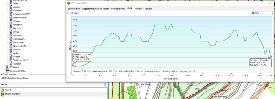
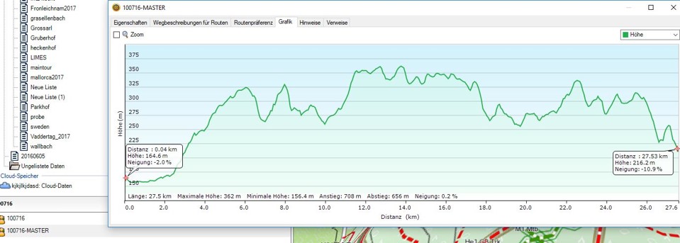
With this test map I can also see the difference in the altitude profiles with and without DEM (based on 10m contour interval): https://postimg.org/gallery/1huzv3m6m/ Please note that the higher accuracy of the DEM profile does not always reflect the elevation in reality, the road beds are always smoothing out the micro relief and thus leading to a lower elevation gain/loss when riding/walking this track.
Hi Minko, yes, that's another reason why I think that the additional "precision" of DEM data in feet doesn't improve anything. Leave alone bridges and tunnels ;-) Also the map data is rounded to the 24 bit raster (~2.3 m) , only DEM uses a 32 bit raster for the points, so whatever Mapsource or Basecamp are doing with the information, it is probably also based on interpolation. In my eyes hill shading makes a map nicer and helps to decide where the hills are, not much more. Off Topic: My experience with height profiles of planned bicycle routes: When you see a spike in the height profile it may mean that the road goes through a tunnel or that you are routed over a steep highway=path acress the hill because it is much shorter than the way around it. Always a good reason to examine the planned route at that point ;-) Gerd ________________________________________ Von: mkgmap-dev <mkgmap-dev-bounces@lists.mkgmap.org.uk> im Auftrag von lig fietser <ligfietser@hotmail.com> Gesendet: Donnerstag, 11. Januar 2018 10:38:24 An: Development list for mkgmap Betreff: Re: [mkgmap-dev] option --show-profiles and DEM With this test map I can also see the difference in the altitude profiles with and without DEM (based on 10m contour interval): https://postimg.org/gallery/1huzv3m6m/ Please note that the higher accuracy of the DEM profile does not always reflect the elevation in reality, the road beds are always smoothing out the micro relief and thus leading to a lower elevation gain/loss when riding/walking this track. _______________________________________________ mkgmap-dev mailing list mkgmap-dev@lists.mkgmap.org.uk http://www.mkgmap.org.uk/mailman/listinfo/mkgmap-dev

Hi Gerd, I think, I have already mentioned it. There are 2 flags written in TDB: "enableProfile" and "hasDem". CGPSmapper supports option for profiles, but it sets flag "hasDem" for it and surely it works with contours. Garmin maps usually include contours and DEM together, and then both flags are set. I have no access to Garmin map that has only one of this features, so I can't tell exact meaning of flags. Some years ago I tested various maps with DEM and some methods to include DEM to free maps. I don't remember what I did, but the conclusion is still present in code of GMapTool. It uses reversed meaning of flags comparing to mkgmap. -- Best regards, Andrzej

Hi all, I don't see a reason to have this option at all. It should be set automatically to 1 if either contour data or DEM is written. If this data is in the map, you always want to have it and if those are not in the map, you don't need it. Or am I wrong? Henning

Am Donnerstag, 11. Januar 2018, 12:55:09 CET schrieb Henning Scholland:
I don't see a reason to have this option at all. It should be set automatically to 1 if either contour data or DEM is written. If this data is in the map, you always want to have it and if those are not in the map, you don't need it. Or am I wrong?
I think you're right. I didn't use this option in the past, today enabled it for testing, but in mapsource and Basecamp the elevation data are visible. Bernd
Hi Andreas, you are right, thanks for the hint. I took those from the transalpin demo map, but the last two levels are empty. So, r4045 now says Example which should work with levels="0:24, 1:22, 2:20, 3:18": --dem-dists=3312,13248,26512,53024 Gerd ________________________________________ Von: mkgmap-dev <mkgmap-dev-bounces@lists.mkgmap.org.uk> im Auftrag von andreas.schmidt.hetschbach@t-online.de <andreas.schmidt.hetschbach@t-online.de> Gesendet: Donnerstag, 11. Januar 2018 14:38:24 An: Development list for mkgmap Betreff: [mkgmap-dev] option --show-profiles and DEM Hi Gerd, I got a bit confused when I read the doc/example --dem-dists=number[,number] If given, the option specifies the resolution(s) or zoom level for the DEM data. If not given, mkgmap tries to determine a reasonable value based on the resolution found in the *.hgt files. For PC programs like MapSource or Basecamp you only need one zoom level, for gps devies you need one for each resolution given with the --levels option. The actual values are given as distance between two DEM points. Higher disances mean lower resolution and thus fewer bytes in the map. Reasonable values for the highest resolution are somewhere between 1648 and 5520, 3312 is often used. Example which should work with levels="0:24, 1:22, 2:20, 3:18, 4:16": --dem-dists=3312,13248,26512,53024 This was found in a Garmin Demo map for transalpin data created 2009. There are only 4 values for –dem-dist ,although there are 5 „Levels“. This seems to be in contrast to „…for gps devies you need one for each resolution given with the --levels Option ? Regards Andreas Gesendet von Mail<https://go.microsoft.com/fwlink/?LinkId=550986> für Windows 10 Von: Henning Scholland<mailto:osm@hscholland.de> Gesendet: Donnerstag, 11. Januar 2018 12:55 An: mkgmap-dev@lists.mkgmap.org.uk<mailto:mkgmap-dev@lists.mkgmap.org.uk> Betreff: Re: [mkgmap-dev] option --show-profiles and DEM Hi all, I don't see a reason to have this option at all. It should be set automatically to 1 if either contour data or DEM is written. If this data is in the map, you always want to have it and if those are not in the map, you don't need it. Or am I wrong? Henning _______________________________________________ mkgmap-dev mailing list mkgmap-dev@lists.mkgmap.org.uk http://www.mkgmap.org.uk/mailman/listinfo/mkgmap-dev
Hi Gerd should 3312 logically be 3314 (2^32/(360*3600)) ? Not that it matters much. r Nick On 11/01/2018 13:48, Gerd Petermann wrote:
Hi Andreas,
you are right, thanks for the hint. I took those from the transalpin demo map, but the last two levels are empty. So, r4045 now says Example which should work with levels="0:24, 1:22, 2:20, 3:18": --dem-dists=3312,13248,26512,53024
Gerd
________________________________________ Von: mkgmap-dev <mkgmap-dev-bounces@lists.mkgmap.org.uk> im Auftrag von andreas.schmidt.hetschbach@t-online.de <andreas.schmidt.hetschbach@t-online.de> Gesendet: Donnerstag, 11. Januar 2018 14:38:24 An: Development list for mkgmap Betreff: [mkgmap-dev] option --show-profiles and DEM
Hi Gerd,
I got a bit confused when I read the doc/example
--dem-dists=number[,number] If given, the option specifies the resolution(s) or zoom level for the DEM data. If not given, mkgmap tries to determine a reasonable value based on the resolution found in the *.hgt files. For PC programs like MapSource or Basecamp you only need one zoom level, for gps devies you need one for each resolution given with the --levels option. The actual values are given as distance between two DEM points. Higher disances mean lower resolution and thus fewer bytes in the map. Reasonable values for the highest resolution are somewhere between 1648 and 5520, 3312 is often used. Example which should work with levels="0:24, 1:22, 2:20, 3:18, 4:16": --dem-dists=3312,13248,26512,53024 This was found in a Garmin Demo map for transalpin data created 2009.
There are only 4 values for –dem-dist ,although there are 5 „Levels“. This seems to be in contrast to „…for gps devies you need one for each resolution given with the --levels Option ?
Regards
Andreas
Gesendet von Mail<https://go.microsoft.com/fwlink/?LinkId=550986> für Windows 10
Von: Henning Scholland<mailto:osm@hscholland.de> Gesendet: Donnerstag, 11. Januar 2018 12:55 An: mkgmap-dev@lists.mkgmap.org.uk<mailto:mkgmap-dev@lists.mkgmap.org.uk> Betreff: Re: [mkgmap-dev] option --show-profiles and DEM
Hi all,
I don't see a reason to have this option at all. It should be set automatically to 1 if either contour data or DEM is written. If this data is in the map, you always want to have it and if those are not in the map, you don't need it. Or am I wrong?
Henning _______________________________________________ mkgmap-dev mailing list mkgmap-dev@lists.mkgmap.org.uk http://www.mkgmap.org.uk/mailman/listinfo/mkgmap-dev _______________________________________________ mkgmap-dev mailing list mkgmap-dev@lists.mkgmap.org.uk http://www.mkgmap.org.uk/mailman/listinfo/mkgmap-dev
Hi Nick, I also wondered why Garmin prefers 3312 while 3314 looks the exacter value. Found no explanation so far. Gerd ________________________________________ Von: mkgmap-dev <mkgmap-dev-bounces@lists.mkgmap.org.uk> im Auftrag von osm@pinns <osm@pinns.co.uk> Gesendet: Donnerstag, 11. Januar 2018 15:04:32 An: mkgmap-dev@lists.mkgmap.org.uk Betreff: Re: [mkgmap-dev] option --show-profiles and DEM Hi Gerd should 3312 logically be 3314 (2^32/(360*3600)) ? Not that it matters much. r Nick On 11/01/2018 13:48, Gerd Petermann wrote:
Hi Andreas,
you are right, thanks for the hint. I took those from the transalpin demo map, but the last two levels are empty. So, r4045 now says Example which should work with levels="0:24, 1:22, 2:20, 3:18": --dem-dists=3312,13248,26512,53024
Gerd
________________________________________ Von: mkgmap-dev <mkgmap-dev-bounces@lists.mkgmap.org.uk> im Auftrag von andreas.schmidt.hetschbach@t-online.de <andreas.schmidt.hetschbach@t-online.de> Gesendet: Donnerstag, 11. Januar 2018 14:38:24 An: Development list for mkgmap Betreff: [mkgmap-dev] option --show-profiles and DEM
Hi Gerd,
I got a bit confused when I read the doc/example
--dem-dists=number[,number] If given, the option specifies the resolution(s) or zoom level for the DEM data. If not given, mkgmap tries to determine a reasonable value based on the resolution found in the *.hgt files. For PC programs like MapSource or Basecamp you only need one zoom level, for gps devies you need one for each resolution given with the --levels option. The actual values are given as distance between two DEM points. Higher disances mean lower resolution and thus fewer bytes in the map. Reasonable values for the highest resolution are somewhere between 1648 and 5520, 3312 is often used. Example which should work with levels="0:24, 1:22, 2:20, 3:18, 4:16": --dem-dists=3312,13248,26512,53024 This was found in a Garmin Demo map for transalpin data created 2009.
There are only 4 values for –dem-dist ,although there are 5 „Levels“. This seems to be in contrast to „…for gps devies you need one for each resolution given with the --levels Option ?
Regards
Andreas
Gesendet von Mail<https://go.microsoft.com/fwlink/?LinkId=550986> für Windows 10
Von: Henning Scholland<mailto:osm@hscholland.de> Gesendet: Donnerstag, 11. Januar 2018 12:55 An: mkgmap-dev@lists.mkgmap.org.uk<mailto:mkgmap-dev@lists.mkgmap.org.uk> Betreff: Re: [mkgmap-dev] option --show-profiles and DEM
Hi all,
I don't see a reason to have this option at all. It should be set automatically to 1 if either contour data or DEM is written. If this data is in the map, you always want to have it and if those are not in the map, you don't need it. Or am I wrong?
Henning _______________________________________________ mkgmap-dev mailing list mkgmap-dev@lists.mkgmap.org.uk http://www.mkgmap.org.uk/mailman/listinfo/mkgmap-dev _______________________________________________ mkgmap-dev mailing list mkgmap-dev@lists.mkgmap.org.uk http://www.mkgmap.org.uk/mailman/listinfo/mkgmap-dev
_______________________________________________ mkgmap-dev mailing list mkgmap-dev@lists.mkgmap.org.uk http://www.mkgmap.org.uk/mailman/listinfo/mkgmap-dev
Hi Gerd, Interesting ; some time ago , you mentioned that you were able to extract these values from the dem file structure. Are they set in the headers? If so where so I can check some of the TOPO's I'm having a problem with my gps64 , not the oregons, where I find its better to opt for a higher starting distance , ie 6628 for 1'' Nick On 11/01/2018 14:10, Gerd Petermann wrote:
Hi Nick,
I also wondered why Garmin prefers 3312 while 3314 looks the exacter value. Found no explanation so far.
Gerd
________________________________________ Von: mkgmap-dev <mkgmap-dev-bounces@lists.mkgmap.org.uk> im Auftrag von osm@pinns <osm@pinns.co.uk> Gesendet: Donnerstag, 11. Januar 2018 15:04:32 An: mkgmap-dev@lists.mkgmap.org.uk Betreff: Re: [mkgmap-dev] option --show-profiles and DEM
Hi Gerd
should 3312 logically be 3314 (2^32/(360*3600)) ?
Not that it matters much.
r
Nick
On 11/01/2018 13:48, Gerd Petermann wrote:
Hi Andreas,
you are right, thanks for the hint. I took those from the transalpin demo map, but the last two levels are empty. So, r4045 now says Example which should work with levels="0:24, 1:22, 2:20, 3:18": --dem-dists=3312,13248,26512,53024
Gerd
________________________________________ Von: mkgmap-dev <mkgmap-dev-bounces@lists.mkgmap.org.uk> im Auftrag von andreas.schmidt.hetschbach@t-online.de <andreas.schmidt.hetschbach@t-online.de> Gesendet: Donnerstag, 11. Januar 2018 14:38:24 An: Development list for mkgmap Betreff: [mkgmap-dev] option --show-profiles and DEM
Hi Gerd,
I got a bit confused when I read the doc/example
--dem-dists=number[,number] If given, the option specifies the resolution(s) or zoom level for the DEM data. If not given, mkgmap tries to determine a reasonable value based on the resolution found in the *.hgt files. For PC programs like MapSource or Basecamp you only need one zoom level, for gps devies you need one for each resolution given with the --levels option. The actual values are given as distance between two DEM points. Higher disances mean lower resolution and thus fewer bytes in the map. Reasonable values for the highest resolution are somewhere between 1648 and 5520, 3312 is often used. Example which should work with levels="0:24, 1:22, 2:20, 3:18, 4:16": --dem-dists=3312,13248,26512,53024 This was found in a Garmin Demo map for transalpin data created 2009.
There are only 4 values for –dem-dist ,although there are 5 „Levels“. This seems to be in contrast to „…for gps devies you need one for each resolution given with the --levels Option ?
Regards
Andreas
Gesendet von Mail<https://go.microsoft.com/fwlink/?LinkId=550986> für Windows 10
Von: Henning Scholland<mailto:osm@hscholland.de> Gesendet: Donnerstag, 11. Januar 2018 12:55 An: mkgmap-dev@lists.mkgmap.org.uk<mailto:mkgmap-dev@lists.mkgmap.org.uk> Betreff: Re: [mkgmap-dev] option --show-profiles and DEM
Hi all,
I don't see a reason to have this option at all. It should be set automatically to 1 if either contour data or DEM is written. If this data is in the map, you always want to have it and if those are not in the map, you don't need it. Or am I wrong?
Henning _______________________________________________ mkgmap-dev mailing list mkgmap-dev@lists.mkgmap.org.uk http://www.mkgmap.org.uk/mailman/listinfo/mkgmap-dev _______________________________________________ mkgmap-dev mailing list mkgmap-dev@lists.mkgmap.org.uk http://www.mkgmap.org.uk/mailman/listinfo/mkgmap-dev
mkgmap-dev mailing list mkgmap-dev@lists.mkgmap.org.uk http://www.mkgmap.org.uk/mailman/listinfo/mkgmap-dev _______________________________________________ mkgmap-dev mailing list mkgmap-dev@lists.mkgmap.org.uk http://www.mkgmap.org.uk/mailman/listinfo/mkgmap-dev
Hi Nick, you need the program DemDisplay from the display tool, source is here: https://svn.mkgmap.org.uk/svn/display/trunk Binary is here: http://files.mkgmap.org.uk/download/386/display.jar Usage on a windows machine : java -cp d:\display\dist\display.jar;d:\mkgmap\dist\mkgmap.jar test.display.DemDisplay [--verbose] input-file > dem.txt (adapt the paths, I think on linux you need : instead of ; as a separator) input-file can be *.DEM or *.IMG containing a dem file. The values are displayed in the "DEM sector header" as "map units between points (latitude):" and "map units between points (longitude)" Gerd ________________________________________ Von: mkgmap-dev <mkgmap-dev-bounces@lists.mkgmap.org.uk> im Auftrag von osm@pinns <osm@pinns.co.uk> Gesendet: Donnerstag, 11. Januar 2018 15:16:18 An: mkgmap-dev@lists.mkgmap.org.uk Betreff: Re: [mkgmap-dev] option --show-profiles and DEM Hi Gerd, Interesting ; some time ago , you mentioned that you were able to extract these values from the dem file structure. Are they set in the headers? If so where so I can check some of the TOPO's I'm having a problem with my gps64 , not the oregons, where I find its better to opt for a higher starting distance , ie 6628 for 1'' Nick On 11/01/2018 14:10, Gerd Petermann wrote:
Hi Nick,
I also wondered why Garmin prefers 3312 while 3314 looks the exacter value. Found no explanation so far.
Gerd
________________________________________ Von: mkgmap-dev <mkgmap-dev-bounces@lists.mkgmap.org.uk> im Auftrag von osm@pinns <osm@pinns.co.uk> Gesendet: Donnerstag, 11. Januar 2018 15:04:32 An: mkgmap-dev@lists.mkgmap.org.uk Betreff: Re: [mkgmap-dev] option --show-profiles and DEM
Hi Gerd
should 3312 logically be 3314 (2^32/(360*3600)) ?
Not that it matters much.
r
Nick
On 11/01/2018 13:48, Gerd Petermann wrote:
Hi Andreas,
you are right, thanks for the hint. I took those from the transalpin demo map, but the last two levels are empty. So, r4045 now says Example which should work with levels="0:24, 1:22, 2:20, 3:18": --dem-dists=3312,13248,26512,53024
Gerd
________________________________________ Von: mkgmap-dev <mkgmap-dev-bounces@lists.mkgmap.org.uk> im Auftrag von andreas.schmidt.hetschbach@t-online.de <andreas.schmidt.hetschbach@t-online.de> Gesendet: Donnerstag, 11. Januar 2018 14:38:24 An: Development list for mkgmap Betreff: [mkgmap-dev] option --show-profiles and DEM
Hi Gerd,
I got a bit confused when I read the doc/example
--dem-dists=number[,number] If given, the option specifies the resolution(s) or zoom level for the DEM data. If not given, mkgmap tries to determine a reasonable value based on the resolution found in the *.hgt files. For PC programs like MapSource or Basecamp you only need one zoom level, for gps devies you need one for each resolution given with the --levels option. The actual values are given as distance between two DEM points. Higher disances mean lower resolution and thus fewer bytes in the map. Reasonable values for the highest resolution are somewhere between 1648 and 5520, 3312 is often used. Example which should work with levels="0:24, 1:22, 2:20, 3:18, 4:16": --dem-dists=3312,13248,26512,53024 This was found in a Garmin Demo map for transalpin data created 2009.
There are only 4 values for –dem-dist ,although there are 5 „Levels“. This seems to be in contrast to „…for gps devies you need one for each resolution given with the --levels Option ?
Regards
Andreas
Gesendet von Mail<https://go.microsoft.com/fwlink/?LinkId=550986> für Windows 10
Von: Henning Scholland<mailto:osm@hscholland.de> Gesendet: Donnerstag, 11. Januar 2018 12:55 An: mkgmap-dev@lists.mkgmap.org.uk<mailto:mkgmap-dev@lists.mkgmap.org.uk> Betreff: Re: [mkgmap-dev] option --show-profiles and DEM
Hi all,
I don't see a reason to have this option at all. It should be set automatically to 1 if either contour data or DEM is written. If this data is in the map, you always want to have it and if those are not in the map, you don't need it. Or am I wrong?
Henning _______________________________________________ mkgmap-dev mailing list mkgmap-dev@lists.mkgmap.org.uk http://www.mkgmap.org.uk/mailman/listinfo/mkgmap-dev _______________________________________________ mkgmap-dev mailing list mkgmap-dev@lists.mkgmap.org.uk http://www.mkgmap.org.uk/mailman/listinfo/mkgmap-dev
mkgmap-dev mailing list mkgmap-dev@lists.mkgmap.org.uk http://www.mkgmap.org.uk/mailman/listinfo/mkgmap-dev _______________________________________________ mkgmap-dev mailing list mkgmap-dev@lists.mkgmap.org.uk http://www.mkgmap.org.uk/mailman/listinfo/mkgmap-dev
_______________________________________________ mkgmap-dev mailing list mkgmap-dev@lists.mkgmap.org.uk http://www.mkgmap.org.uk/mailman/listinfo/mkgmap-dev
Hi Gerd, Superb ! Many thanks ! Nick On 11/01/2018 14:29, Gerd Petermann wrote:
Hi Nick,
you need the program DemDisplay from the display tool, source is here: https://svn.mkgmap.org.uk/svn/display/trunk Binary is here: http://files.mkgmap.org.uk/download/386/display.jar
Usage on a windows machine : java -cp d:\display\dist\display.jar;d:\mkgmap\dist\mkgmap.jar test.display.DemDisplay [--verbose] input-file > dem.txt (adapt the paths, I think on linux you need : instead of ; as a separator) input-file can be *.DEM or *.IMG containing a dem file.
The values are displayed in the "DEM sector header" as "map units between points (latitude):" and "map units between points (longitude)"
Gerd
________________________________________ Von: mkgmap-dev <mkgmap-dev-bounces@lists.mkgmap.org.uk> im Auftrag von osm@pinns <osm@pinns.co.uk> Gesendet: Donnerstag, 11. Januar 2018 15:16:18 An: mkgmap-dev@lists.mkgmap.org.uk Betreff: Re: [mkgmap-dev] option --show-profiles and DEM
Hi Gerd,
Interesting ; some time ago , you mentioned that you were able to extract these values from the dem file structure.
Are they set in the headers? If so where so I can check some of the TOPO's
I'm having a problem with my gps64 , not the oregons, where I find its better to opt for a higher starting distance , ie 6628 for 1''
Nick
On 11/01/2018 14:10, Gerd Petermann wrote:
Hi Nick,
I also wondered why Garmin prefers 3312 while 3314 looks the exacter value. Found no explanation so far.
Gerd
________________________________________ Von: mkgmap-dev <mkgmap-dev-bounces@lists.mkgmap.org.uk> im Auftrag von osm@pinns <osm@pinns.co.uk> Gesendet: Donnerstag, 11. Januar 2018 15:04:32 An: mkgmap-dev@lists.mkgmap.org.uk Betreff: Re: [mkgmap-dev] option --show-profiles and DEM
Hi Gerd
should 3312 logically be 3314 (2^32/(360*3600)) ?
Not that it matters much.
r
Nick
On 11/01/2018 13:48, Gerd Petermann wrote:
Hi Andreas,
you are right, thanks for the hint. I took those from the transalpin demo map, but the last two levels are empty. So, r4045 now says Example which should work with levels="0:24, 1:22, 2:20, 3:18": --dem-dists=3312,13248,26512,53024
Gerd
________________________________________ Von: mkgmap-dev <mkgmap-dev-bounces@lists.mkgmap.org.uk> im Auftrag von andreas.schmidt.hetschbach@t-online.de <andreas.schmidt.hetschbach@t-online.de> Gesendet: Donnerstag, 11. Januar 2018 14:38:24 An: Development list for mkgmap Betreff: [mkgmap-dev] option --show-profiles and DEM
Hi Gerd,
I got a bit confused when I read the doc/example
--dem-dists=number[,number] If given, the option specifies the resolution(s) or zoom level for the DEM data. If not given, mkgmap tries to determine a reasonable value based on the resolution found in the *.hgt files. For PC programs like MapSource or Basecamp you only need one zoom level, for gps devies you need one for each resolution given with the --levels option. The actual values are given as distance between two DEM points. Higher disances mean lower resolution and thus fewer bytes in the map. Reasonable values for the highest resolution are somewhere between 1648 and 5520, 3312 is often used. Example which should work with levels="0:24, 1:22, 2:20, 3:18, 4:16": --dem-dists=3312,13248,26512,53024 This was found in a Garmin Demo map for transalpin data created 2009.
There are only 4 values for –dem-dist ,although there are 5 „Levels“. This seems to be in contrast to „…for gps devies you need one for each resolution given with the --levels Option ?
Regards
Andreas
Gesendet von Mail<https://go.microsoft.com/fwlink/?LinkId=550986> für Windows 10
Von: Henning Scholland<mailto:osm@hscholland.de> Gesendet: Donnerstag, 11. Januar 2018 12:55 An: mkgmap-dev@lists.mkgmap.org.uk<mailto:mkgmap-dev@lists.mkgmap.org.uk> Betreff: Re: [mkgmap-dev] option --show-profiles and DEM
Hi all,
I don't see a reason to have this option at all. It should be set automatically to 1 if either contour data or DEM is written. If this data is in the map, you always want to have it and if those are not in the map, you don't need it. Or am I wrong?
Henning _______________________________________________ mkgmap-dev mailing list mkgmap-dev@lists.mkgmap.org.uk http://www.mkgmap.org.uk/mailman/listinfo/mkgmap-dev _______________________________________________ mkgmap-dev mailing list mkgmap-dev@lists.mkgmap.org.uk http://www.mkgmap.org.uk/mailman/listinfo/mkgmap-dev
mkgmap-dev mailing list mkgmap-dev@lists.mkgmap.org.uk http://www.mkgmap.org.uk/mailman/listinfo/mkgmap-dev _______________________________________________ mkgmap-dev mailing list mkgmap-dev@lists.mkgmap.org.uk http://www.mkgmap.org.uk/mailman/listinfo/mkgmap-dev
mkgmap-dev mailing list mkgmap-dev@lists.mkgmap.org.uk http://www.mkgmap.org.uk/mailman/listinfo/mkgmap-dev _______________________________________________ mkgmap-dev mailing list mkgmap-dev@lists.mkgmap.org.uk http://www.mkgmap.org.uk/mailman/listinfo/mkgmap-dev
Hi Nick, see also http://gis.19327.n8.nabble.com/r4006-1st-alpha-version-to-write-DEM-data-tp5... where I posted my findings. Gerd ________________________________________ Von: mkgmap-dev <mkgmap-dev-bounces@lists.mkgmap.org.uk> im Auftrag von osm@pinns <osm@pinns.co.uk> Gesendet: Donnerstag, 11. Januar 2018 15:30:11 An: mkgmap-dev@lists.mkgmap.org.uk Betreff: Re: [mkgmap-dev] option --show-profiles and DEM Hi Gerd, Superb ! Many thanks ! Nick On 11/01/2018 14:29, Gerd Petermann wrote:
Hi Nick,
you need the program DemDisplay from the display tool, source is here: https://svn.mkgmap.org.uk/svn/display/trunk Binary is here: http://files.mkgmap.org.uk/download/386/display.jar
Usage on a windows machine : java -cp d:\display\dist\display.jar;d:\mkgmap\dist\mkgmap.jar test.display.DemDisplay [--verbose] input-file > dem.txt (adapt the paths, I think on linux you need : instead of ; as a separator) input-file can be *.DEM or *.IMG containing a dem file.
The values are displayed in the "DEM sector header" as "map units between points (latitude):" and "map units between points (longitude)"
Gerd
________________________________________ Von: mkgmap-dev <mkgmap-dev-bounces@lists.mkgmap.org.uk> im Auftrag von osm@pinns <osm@pinns.co.uk> Gesendet: Donnerstag, 11. Januar 2018 15:16:18 An: mkgmap-dev@lists.mkgmap.org.uk Betreff: Re: [mkgmap-dev] option --show-profiles and DEM
Hi Gerd,
Interesting ; some time ago , you mentioned that you were able to extract these values from the dem file structure.
Are they set in the headers? If so where so I can check some of the TOPO's
I'm having a problem with my gps64 , not the oregons, where I find its better to opt for a higher starting distance , ie 6628 for 1''
Nick
On 11/01/2018 14:10, Gerd Petermann wrote:
Hi Nick,
I also wondered why Garmin prefers 3312 while 3314 looks the exacter value. Found no explanation so far.
Gerd
________________________________________ Von: mkgmap-dev <mkgmap-dev-bounces@lists.mkgmap.org.uk> im Auftrag von osm@pinns <osm@pinns.co.uk> Gesendet: Donnerstag, 11. Januar 2018 15:04:32 An: mkgmap-dev@lists.mkgmap.org.uk Betreff: Re: [mkgmap-dev] option --show-profiles and DEM
Hi Gerd
should 3312 logically be 3314 (2^32/(360*3600)) ?
Not that it matters much.
r
Nick
On 11/01/2018 13:48, Gerd Petermann wrote:
Hi Andreas,
you are right, thanks for the hint. I took those from the transalpin demo map, but the last two levels are empty. So, r4045 now says Example which should work with levels="0:24, 1:22, 2:20, 3:18": --dem-dists=3312,13248,26512,53024
Gerd
________________________________________ Von: mkgmap-dev <mkgmap-dev-bounces@lists.mkgmap.org.uk> im Auftrag von andreas.schmidt.hetschbach@t-online.de <andreas.schmidt.hetschbach@t-online.de> Gesendet: Donnerstag, 11. Januar 2018 14:38:24 An: Development list for mkgmap Betreff: [mkgmap-dev] option --show-profiles and DEM
Hi Gerd,
I got a bit confused when I read the doc/example
--dem-dists=number[,number] If given, the option specifies the resolution(s) or zoom level for the DEM data. If not given, mkgmap tries to determine a reasonable value based on the resolution found in the *.hgt files. For PC programs like MapSource or Basecamp you only need one zoom level, for gps devies you need one for each resolution given with the --levels option. The actual values are given as distance between two DEM points. Higher disances mean lower resolution and thus fewer bytes in the map. Reasonable values for the highest resolution are somewhere between 1648 and 5520, 3312 is often used. Example which should work with levels="0:24, 1:22, 2:20, 3:18, 4:16": --dem-dists=3312,13248,26512,53024 This was found in a Garmin Demo map for transalpin data created 2009.
There are only 4 values for –dem-dist ,although there are 5 „Levels“. This seems to be in contrast to „…for gps devies you need one for each resolution given with the --levels Option ?
Regards
Andreas
Gesendet von Mail<https://go.microsoft.com/fwlink/?LinkId=550986> für Windows 10
Von: Henning Scholland<mailto:osm@hscholland.de> Gesendet: Donnerstag, 11. Januar 2018 12:55 An: mkgmap-dev@lists.mkgmap.org.uk<mailto:mkgmap-dev@lists.mkgmap.org.uk> Betreff: Re: [mkgmap-dev] option --show-profiles and DEM
Hi all,
I don't see a reason to have this option at all. It should be set automatically to 1 if either contour data or DEM is written. If this data is in the map, you always want to have it and if those are not in the map, you don't need it. Or am I wrong?
Henning _______________________________________________ mkgmap-dev mailing list mkgmap-dev@lists.mkgmap.org.uk http://www.mkgmap.org.uk/mailman/listinfo/mkgmap-dev _______________________________________________ mkgmap-dev mailing list mkgmap-dev@lists.mkgmap.org.uk http://www.mkgmap.org.uk/mailman/listinfo/mkgmap-dev
mkgmap-dev mailing list mkgmap-dev@lists.mkgmap.org.uk http://www.mkgmap.org.uk/mailman/listinfo/mkgmap-dev _______________________________________________ mkgmap-dev mailing list mkgmap-dev@lists.mkgmap.org.uk http://www.mkgmap.org.uk/mailman/listinfo/mkgmap-dev
mkgmap-dev mailing list mkgmap-dev@lists.mkgmap.org.uk http://www.mkgmap.org.uk/mailman/listinfo/mkgmap-dev _______________________________________________ mkgmap-dev mailing list mkgmap-dev@lists.mkgmap.org.uk http://www.mkgmap.org.uk/mailman/listinfo/mkgmap-dev
_______________________________________________ mkgmap-dev mailing list mkgmap-dev@lists.mkgmap.org.uk http://www.mkgmap.org.uk/mailman/listinfo/mkgmap-dev
Hi Gerd, Thanks , will keep you posted about any unusual findings. Nick On 11/01/2018 14:37, Gerd Petermann wrote:
Hi Nick,
see also http://gis.19327.n8.nabble.com/r4006-1st-alpha-version-to-write-DEM-data-tp5... where I posted my findings.
Gerd
________________________________________ Von: mkgmap-dev <mkgmap-dev-bounces@lists.mkgmap.org.uk> im Auftrag von osm@pinns <osm@pinns.co.uk> Gesendet: Donnerstag, 11. Januar 2018 15:30:11 An: mkgmap-dev@lists.mkgmap.org.uk Betreff: Re: [mkgmap-dev] option --show-profiles and DEM
Hi Gerd,
Superb ! Many thanks !
Nick
On 11/01/2018 14:29, Gerd Petermann wrote:
Hi Nick,
you need the program DemDisplay from the display tool, source is here: https://svn.mkgmap.org.uk/svn/display/trunk Binary is here: http://files.mkgmap.org.uk/download/386/display.jar
Usage on a windows machine : java -cp d:\display\dist\display.jar;d:\mkgmap\dist\mkgmap.jar test.display.DemDisplay [--verbose] input-file > dem.txt (adapt the paths, I think on linux you need : instead of ; as a separator) input-file can be *.DEM or *.IMG containing a dem file.
The values are displayed in the "DEM sector header" as "map units between points (latitude):" and "map units between points (longitude)"
Gerd
________________________________________ Von: mkgmap-dev <mkgmap-dev-bounces@lists.mkgmap.org.uk> im Auftrag von osm@pinns <osm@pinns.co.uk> Gesendet: Donnerstag, 11. Januar 2018 15:16:18 An: mkgmap-dev@lists.mkgmap.org.uk Betreff: Re: [mkgmap-dev] option --show-profiles and DEM
Hi Gerd,
Interesting ; some time ago , you mentioned that you were able to extract these values from the dem file structure.
Are they set in the headers? If so where so I can check some of the TOPO's
I'm having a problem with my gps64 , not the oregons, where I find its better to opt for a higher starting distance , ie 6628 for 1''
Nick
On 11/01/2018 14:10, Gerd Petermann wrote:
Hi Nick,
I also wondered why Garmin prefers 3312 while 3314 looks the exacter value. Found no explanation so far.
Gerd
________________________________________ Von: mkgmap-dev <mkgmap-dev-bounces@lists.mkgmap.org.uk> im Auftrag von osm@pinns <osm@pinns.co.uk> Gesendet: Donnerstag, 11. Januar 2018 15:04:32 An: mkgmap-dev@lists.mkgmap.org.uk Betreff: Re: [mkgmap-dev] option --show-profiles and DEM
Hi Gerd
should 3312 logically be 3314 (2^32/(360*3600)) ?
Not that it matters much.
r
Nick
On 11/01/2018 13:48, Gerd Petermann wrote:
Hi Andreas,
you are right, thanks for the hint. I took those from the transalpin demo map, but the last two levels are empty. So, r4045 now says Example which should work with levels="0:24, 1:22, 2:20, 3:18": --dem-dists=3312,13248,26512,53024
Gerd
________________________________________ Von: mkgmap-dev <mkgmap-dev-bounces@lists.mkgmap.org.uk> im Auftrag von andreas.schmidt.hetschbach@t-online.de <andreas.schmidt.hetschbach@t-online.de> Gesendet: Donnerstag, 11. Januar 2018 14:38:24 An: Development list for mkgmap Betreff: [mkgmap-dev] option --show-profiles and DEM
Hi Gerd,
I got a bit confused when I read the doc/example
--dem-dists=number[,number] If given, the option specifies the resolution(s) or zoom level for the DEM data. If not given, mkgmap tries to determine a reasonable value based on the resolution found in the *.hgt files. For PC programs like MapSource or Basecamp you only need one zoom level, for gps devies you need one for each resolution given with the --levels option. The actual values are given as distance between two DEM points. Higher disances mean lower resolution and thus fewer bytes in the map. Reasonable values for the highest resolution are somewhere between 1648 and 5520, 3312 is often used. Example which should work with levels="0:24, 1:22, 2:20, 3:18, 4:16": --dem-dists=3312,13248,26512,53024 This was found in a Garmin Demo map for transalpin data created 2009.
There are only 4 values for –dem-dist ,although there are 5 „Levels“. This seems to be in contrast to „…for gps devies you need one for each resolution given with the --levels Option ?
Regards
Andreas
Gesendet von Mail<https://go.microsoft.com/fwlink/?LinkId=550986> für Windows 10
Von: Henning Scholland<mailto:osm@hscholland.de> Gesendet: Donnerstag, 11. Januar 2018 12:55 An: mkgmap-dev@lists.mkgmap.org.uk<mailto:mkgmap-dev@lists.mkgmap.org.uk> Betreff: Re: [mkgmap-dev] option --show-profiles and DEM
Hi all,
I don't see a reason to have this option at all. It should be set automatically to 1 if either contour data or DEM is written. If this data is in the map, you always want to have it and if those are not in the map, you don't need it. Or am I wrong?
Henning _______________________________________________ mkgmap-dev mailing list mkgmap-dev@lists.mkgmap.org.uk http://www.mkgmap.org.uk/mailman/listinfo/mkgmap-dev _______________________________________________ mkgmap-dev mailing list mkgmap-dev@lists.mkgmap.org.uk http://www.mkgmap.org.uk/mailman/listinfo/mkgmap-dev
mkgmap-dev mailing list mkgmap-dev@lists.mkgmap.org.uk http://www.mkgmap.org.uk/mailman/listinfo/mkgmap-dev _______________________________________________ mkgmap-dev mailing list mkgmap-dev@lists.mkgmap.org.uk http://www.mkgmap.org.uk/mailman/listinfo/mkgmap-dev
mkgmap-dev mailing list mkgmap-dev@lists.mkgmap.org.uk http://www.mkgmap.org.uk/mailman/listinfo/mkgmap-dev _______________________________________________ mkgmap-dev mailing list mkgmap-dev@lists.mkgmap.org.uk http://www.mkgmap.org.uk/mailman/listinfo/mkgmap-dev
mkgmap-dev mailing list mkgmap-dev@lists.mkgmap.org.uk http://www.mkgmap.org.uk/mailman/listinfo/mkgmap-dev _______________________________________________ mkgmap-dev mailing list mkgmap-dev@lists.mkgmap.org.uk http://www.mkgmap.org.uk/mailman/listinfo/mkgmap-dev
Hi Nick, I've uplodaed display.jar r515: http://files.mkgmap.org.uk/download/388/display.jar See http://www.mkgmap.org.uk/websvn/revision.php?repname=display&rev=515 The previous one also contained an experimental patch in MdrCheck which was not in the svn repo. Gerd ________________________________________ Von: mkgmap-dev <mkgmap-dev-bounces@lists.mkgmap.org.uk> im Auftrag von osm@pinns <osm@pinns.co.uk> Gesendet: Donnerstag, 11. Januar 2018 15:39:04 An: mkgmap-dev@lists.mkgmap.org.uk Betreff: Re: [mkgmap-dev] option --show-profiles and DEM Hi Gerd, Thanks , will keep you posted about any unusual findings. Nick On 11/01/2018 14:37, Gerd Petermann wrote:
Hi Nick,
see also http://gis.19327.n8.nabble.com/r4006-1st-alpha-version-to-write-DEM-data-tp5... where I posted my findings.
Gerd
________________________________________ Von: mkgmap-dev <mkgmap-dev-bounces@lists.mkgmap.org.uk> im Auftrag von osm@pinns <osm@pinns.co.uk> Gesendet: Donnerstag, 11. Januar 2018 15:30:11 An: mkgmap-dev@lists.mkgmap.org.uk Betreff: Re: [mkgmap-dev] option --show-profiles and DEM
Hi Gerd,
Superb ! Many thanks !
Nick
On 11/01/2018 14:29, Gerd Petermann wrote:
Hi Nick,
you need the program DemDisplay from the display tool, source is here: https://svn.mkgmap.org.uk/svn/display/trunk Binary is here: http://files.mkgmap.org.uk/download/386/display.jar
Usage on a windows machine : java -cp d:\display\dist\display.jar;d:\mkgmap\dist\mkgmap.jar test.display.DemDisplay [--verbose] input-file > dem.txt (adapt the paths, I think on linux you need : instead of ; as a separator) input-file can be *.DEM or *.IMG containing a dem file.
The values are displayed in the "DEM sector header" as "map units between points (latitude):" and "map units between points (longitude)"
Gerd
________________________________________ Von: mkgmap-dev <mkgmap-dev-bounces@lists.mkgmap.org.uk> im Auftrag von osm@pinns <osm@pinns.co.uk> Gesendet: Donnerstag, 11. Januar 2018 15:16:18 An: mkgmap-dev@lists.mkgmap.org.uk Betreff: Re: [mkgmap-dev] option --show-profiles and DEM
Hi Gerd,
Interesting ; some time ago , you mentioned that you were able to extract these values from the dem file structure.
Are they set in the headers? If so where so I can check some of the TOPO's
I'm having a problem with my gps64 , not the oregons, where I find its better to opt for a higher starting distance , ie 6628 for 1''
Nick
On 11/01/2018 14:10, Gerd Petermann wrote:
Hi Nick,
I also wondered why Garmin prefers 3312 while 3314 looks the exacter value. Found no explanation so far.
Gerd
________________________________________ Von: mkgmap-dev <mkgmap-dev-bounces@lists.mkgmap.org.uk> im Auftrag von osm@pinns <osm@pinns.co.uk> Gesendet: Donnerstag, 11. Januar 2018 15:04:32 An: mkgmap-dev@lists.mkgmap.org.uk Betreff: Re: [mkgmap-dev] option --show-profiles and DEM
Hi Gerd
should 3312 logically be 3314 (2^32/(360*3600)) ?
Not that it matters much.
r
Nick
On 11/01/2018 13:48, Gerd Petermann wrote:
Hi Andreas,
you are right, thanks for the hint. I took those from the transalpin demo map, but the last two levels are empty. So, r4045 now says Example which should work with levels="0:24, 1:22, 2:20, 3:18": --dem-dists=3312,13248,26512,53024
Gerd
________________________________________ Von: mkgmap-dev <mkgmap-dev-bounces@lists.mkgmap.org.uk> im Auftrag von andreas.schmidt.hetschbach@t-online.de <andreas.schmidt.hetschbach@t-online.de> Gesendet: Donnerstag, 11. Januar 2018 14:38:24 An: Development list for mkgmap Betreff: [mkgmap-dev] option --show-profiles and DEM
Hi Gerd,
I got a bit confused when I read the doc/example
--dem-dists=number[,number] If given, the option specifies the resolution(s) or zoom level for the DEM data. If not given, mkgmap tries to determine a reasonable value based on the resolution found in the *.hgt files. For PC programs like MapSource or Basecamp you only need one zoom level, for gps devies you need one for each resolution given with the --levels option. The actual values are given as distance between two DEM points. Higher disances mean lower resolution and thus fewer bytes in the map. Reasonable values for the highest resolution are somewhere between 1648 and 5520, 3312 is often used. Example which should work with levels="0:24, 1:22, 2:20, 3:18, 4:16": --dem-dists=3312,13248,26512,53024 This was found in a Garmin Demo map for transalpin data created 2009.
There are only 4 values for –dem-dist ,although there are 5 „Levels“. This seems to be in contrast to „…for gps devies you need one for each resolution given with the --levels Option ?
Regards
Andreas
Gesendet von Mail<https://go.microsoft.com/fwlink/?LinkId=550986> für Windows 10
Von: Henning Scholland<mailto:osm@hscholland.de> Gesendet: Donnerstag, 11. Januar 2018 12:55 An: mkgmap-dev@lists.mkgmap.org.uk<mailto:mkgmap-dev@lists.mkgmap.org.uk> Betreff: Re: [mkgmap-dev] option --show-profiles and DEM
Hi all,
I don't see a reason to have this option at all. It should be set automatically to 1 if either contour data or DEM is written. If this data is in the map, you always want to have it and if those are not in the map, you don't need it. Or am I wrong?
Henning _______________________________________________ mkgmap-dev mailing list mkgmap-dev@lists.mkgmap.org.uk http://www.mkgmap.org.uk/mailman/listinfo/mkgmap-dev _______________________________________________ mkgmap-dev mailing list mkgmap-dev@lists.mkgmap.org.uk http://www.mkgmap.org.uk/mailman/listinfo/mkgmap-dev
mkgmap-dev mailing list mkgmap-dev@lists.mkgmap.org.uk http://www.mkgmap.org.uk/mailman/listinfo/mkgmap-dev _______________________________________________ mkgmap-dev mailing list mkgmap-dev@lists.mkgmap.org.uk http://www.mkgmap.org.uk/mailman/listinfo/mkgmap-dev
mkgmap-dev mailing list mkgmap-dev@lists.mkgmap.org.uk http://www.mkgmap.org.uk/mailman/listinfo/mkgmap-dev _______________________________________________ mkgmap-dev mailing list mkgmap-dev@lists.mkgmap.org.uk http://www.mkgmap.org.uk/mailman/listinfo/mkgmap-dev
mkgmap-dev mailing list mkgmap-dev@lists.mkgmap.org.uk http://www.mkgmap.org.uk/mailman/listinfo/mkgmap-dev _______________________________________________ mkgmap-dev mailing list mkgmap-dev@lists.mkgmap.org.uk http://www.mkgmap.org.uk/mailman/listinfo/mkgmap-dev
_______________________________________________ mkgmap-dev mailing list mkgmap-dev@lists.mkgmap.org.uk http://www.mkgmap.org.uk/mailman/listinfo/mkgmap-dev
Hi Gerd Many thanks so far I've got similar results as you have had ie an old GB TOPO :1648,3312,13248,53024 an old Swiss : 3312,13248,53024,212096 another one : 3312,6624,26512,106048,424192,1696768 I've also been extracting the dem from some GMP files but clearly the structure is quite different with no offsetts at 0x21 and then 0x30 Nick On 12/01/2018 10:00, Gerd Petermann wrote:
Hi Nick,
I've uplodaed display.jar r515: http://files.mkgmap.org.uk/download/388/display.jar See http://www.mkgmap.org.uk/websvn/revision.php?repname=display&rev=515 The previous one also contained an experimental patch in MdrCheck which was not in the svn repo.
Gerd
________________________________________ Von: mkgmap-dev <mkgmap-dev-bounces@lists.mkgmap.org.uk> im Auftrag von osm@pinns <osm@pinns.co.uk> Gesendet: Donnerstag, 11. Januar 2018 15:39:04 An: mkgmap-dev@lists.mkgmap.org.uk Betreff: Re: [mkgmap-dev] option --show-profiles and DEM
Hi Gerd,
Thanks , will keep you posted about any unusual findings.
Nick
On 11/01/2018 14:37, Gerd Petermann wrote:
Hi Nick,
see also http://gis.19327.n8.nabble.com/r4006-1st-alpha-version-to-write-DEM-data-tp5... where I posted my findings.
Gerd
________________________________________ Von: mkgmap-dev <mkgmap-dev-bounces@lists.mkgmap.org.uk> im Auftrag von osm@pinns <osm@pinns.co.uk> Gesendet: Donnerstag, 11. Januar 2018 15:30:11 An: mkgmap-dev@lists.mkgmap.org.uk Betreff: Re: [mkgmap-dev] option --show-profiles and DEM
Hi Gerd,
Superb ! Many thanks !
Nick
On 11/01/2018 14:29, Gerd Petermann wrote:
Hi Nick,
you need the program DemDisplay from the display tool, source is here: https://svn.mkgmap.org.uk/svn/display/trunk Binary is here: http://files.mkgmap.org.uk/download/386/display.jar
Usage on a windows machine : java -cp d:\display\dist\display.jar;d:\mkgmap\dist\mkgmap.jar test.display.DemDisplay [--verbose] input-file > dem.txt (adapt the paths, I think on linux you need : instead of ; as a separator) input-file can be *.DEM or *.IMG containing a dem file.
The values are displayed in the "DEM sector header" as "map units between points (latitude):" and "map units between points (longitude)"
Gerd
________________________________________ Von: mkgmap-dev <mkgmap-dev-bounces@lists.mkgmap.org.uk> im Auftrag von osm@pinns <osm@pinns.co.uk> Gesendet: Donnerstag, 11. Januar 2018 15:16:18 An: mkgmap-dev@lists.mkgmap.org.uk Betreff: Re: [mkgmap-dev] option --show-profiles and DEM
Hi Gerd,
Interesting ; some time ago , you mentioned that you were able to extract these values from the dem file structure.
Are they set in the headers? If so where so I can check some of the TOPO's
I'm having a problem with my gps64 , not the oregons, where I find its better to opt for a higher starting distance , ie 6628 for 1''
Nick
On 11/01/2018 14:10, Gerd Petermann wrote:
Hi Nick,
I also wondered why Garmin prefers 3312 while 3314 looks the exacter value. Found no explanation so far.
Gerd
________________________________________ Von: mkgmap-dev <mkgmap-dev-bounces@lists.mkgmap.org.uk> im Auftrag von osm@pinns <osm@pinns.co.uk> Gesendet: Donnerstag, 11. Januar 2018 15:04:32 An: mkgmap-dev@lists.mkgmap.org.uk Betreff: Re: [mkgmap-dev] option --show-profiles and DEM
Hi Gerd
should 3312 logically be 3314 (2^32/(360*3600)) ?
Not that it matters much.
r
Nick
On 11/01/2018 13:48, Gerd Petermann wrote:
Hi Andreas,
you are right, thanks for the hint. I took those from the transalpin demo map, but the last two levels are empty. So, r4045 now says Example which should work with levels="0:24, 1:22, 2:20, 3:18": --dem-dists=3312,13248,26512,53024
Gerd
________________________________________ Von: mkgmap-dev <mkgmap-dev-bounces@lists.mkgmap.org.uk> im Auftrag von andreas.schmidt.hetschbach@t-online.de <andreas.schmidt.hetschbach@t-online.de> Gesendet: Donnerstag, 11. Januar 2018 14:38:24 An: Development list for mkgmap Betreff: [mkgmap-dev] option --show-profiles and DEM
Hi Gerd,
I got a bit confused when I read the doc/example
--dem-dists=number[,number] If given, the option specifies the resolution(s) or zoom level for the DEM data. If not given, mkgmap tries to determine a reasonable value based on the resolution found in the *.hgt files. For PC programs like MapSource or Basecamp you only need one zoom level, for gps devies you need one for each resolution given with the --levels option. The actual values are given as distance between two DEM points. Higher disances mean lower resolution and thus fewer bytes in the map. Reasonable values for the highest resolution are somewhere between 1648 and 5520, 3312 is often used. Example which should work with levels="0:24, 1:22, 2:20, 3:18, 4:16": --dem-dists=3312,13248,26512,53024 This was found in a Garmin Demo map for transalpin data created 2009.
There are only 4 values for –dem-dist ,although there are 5 „Levels“. This seems to be in contrast to „…for gps devies you need one for each resolution given with the --levels Option ?
Regards
Andreas
Gesendet von Mail<https://go.microsoft.com/fwlink/?LinkId=550986> für Windows 10
Von: Henning Scholland<mailto:osm@hscholland.de> Gesendet: Donnerstag, 11. Januar 2018 12:55 An: mkgmap-dev@lists.mkgmap.org.uk<mailto:mkgmap-dev@lists.mkgmap.org.uk> Betreff: Re: [mkgmap-dev] option --show-profiles and DEM
Hi all,
I don't see a reason to have this option at all. It should be set automatically to 1 if either contour data or DEM is written. If this data is in the map, you always want to have it and if those are not in the map, you don't need it. Or am I wrong?
Henning _______________________________________________ mkgmap-dev mailing list mkgmap-dev@lists.mkgmap.org.uk http://www.mkgmap.org.uk/mailman/listinfo/mkgmap-dev _______________________________________________ mkgmap-dev mailing list mkgmap-dev@lists.mkgmap.org.uk http://www.mkgmap.org.uk/mailman/listinfo/mkgmap-dev
mkgmap-dev mailing list mkgmap-dev@lists.mkgmap.org.uk http://www.mkgmap.org.uk/mailman/listinfo/mkgmap-dev _______________________________________________ mkgmap-dev mailing list mkgmap-dev@lists.mkgmap.org.uk http://www.mkgmap.org.uk/mailman/listinfo/mkgmap-dev
mkgmap-dev mailing list mkgmap-dev@lists.mkgmap.org.uk http://www.mkgmap.org.uk/mailman/listinfo/mkgmap-dev _______________________________________________ mkgmap-dev mailing list mkgmap-dev@lists.mkgmap.org.uk http://www.mkgmap.org.uk/mailman/listinfo/mkgmap-dev
mkgmap-dev mailing list mkgmap-dev@lists.mkgmap.org.uk http://www.mkgmap.org.uk/mailman/listinfo/mkgmap-dev _______________________________________________ mkgmap-dev mailing list mkgmap-dev@lists.mkgmap.org.uk http://www.mkgmap.org.uk/mailman/listinfo/mkgmap-dev
mkgmap-dev mailing list mkgmap-dev@lists.mkgmap.org.uk http://www.mkgmap.org.uk/mailman/listinfo/mkgmap-dev _______________________________________________ mkgmap-dev mailing list mkgmap-dev@lists.mkgmap.org.uk http://www.mkgmap.org.uk/mailman/listinfo/mkgmap-dev
Hi Nick, DEM in GMP should be the same. The difference is, that in DEM subfile headers starts at 0, but in GMP header is at address contained at offset 0x2D. If you want to analyze DEM then algorithm is something like that: char *subfile int offset; if (typ == DEM) offset = 0 if (typ == GMP) offset = *(int *)(subfile + 0x2D); HEADER_DEM *header = (HEADER_DEM *)(subfile + offset) And then you can access DEM data basing on header content. Pointers in header are correct regardless of header position inside subfile, they are always relative to beginning of subfile. -- Best regards, Andrzej
Hi Andrzej, thanks for the hint. I'll try to code that in DemDisplay today. Gerd ________________________________________ Von: mkgmap-dev <mkgmap-dev-bounces@lists.mkgmap.org.uk> im Auftrag von Andrzej Popowski <popej@poczta.onet.pl> Gesendet: Freitag, 12. Januar 2018 13:10:32 An: mkgmap-dev@lists.mkgmap.org.uk Betreff: Re: [mkgmap-dev] option --show-profiles and DEM Hi Nick, DEM in GMP should be the same. The difference is, that in DEM subfile headers starts at 0, but in GMP header is at address contained at offset 0x2D. If you want to analyze DEM then algorithm is something like that: char *subfile int offset; if (typ == DEM) offset = 0 if (typ == GMP) offset = *(int *)(subfile + 0x2D); HEADER_DEM *header = (HEADER_DEM *)(subfile + offset) And then you can access DEM data basing on header content. Pointers in header are correct regardless of header position inside subfile, they are always relative to beginning of subfile. -- Best regards, Andrzej _______________________________________________ mkgmap-dev mailing list mkgmap-dev@lists.mkgmap.org.uk http://www.mkgmap.org.uk/mailman/listinfo/mkgmap-dev
Hi Andrzej Thanks for that Nick On 12/01/2018 12:10, Andrzej Popowski wrote:
Hi Nick,
DEM in GMP should be the same. The difference is, that in DEM subfile headers starts at 0, but in GMP header is at address contained at offset 0x2D. If you want to analyze DEM then algorithm is something like that:
char *subfile int offset;
if (typ == DEM) offset = 0 if (typ == GMP) offset = *(int *)(subfile + 0x2D);
HEADER_DEM *header = (HEADER_DEM *)(subfile + offset)
And then you can access DEM data basing on header content. Pointers in header are correct regardless of header position inside subfile, they are always relative to beginning of subfile.

Hi, Test of "my" .hgt files completed, right now. Background: ---------------------------------------------- - I'm not involved in your project, but I appreciate it very much !!! - I don't speak Java, but a bit JavaScript - I wanted to enrich my .gpx files out from Basecamp with height-data. - Project: WWW-Solution, NAS on my desk. http://tinyurl.com/yact8gm6 - 1. Try: Google Elevation service: Forget it in the mountains :-( - 2. Try: Use .hgt files, started with 3sec files from Viewfinderpanorama, not satisfactoring :-( - 3. Try: Use 1sec files from USGS http://dwtkns.com/srtm30m/ Hey, did work fine, but no files for the North available. - 4. Try: For the North, add files from Viewfinderpanorama Questions: ---------------------------------------------- Do I need all this if you add height-data to the OSM-maps ??? Will the results be comparable with using the original 1sec .hgt data ??? Dit you really find better height-data from Copernicus, will the .hgt-files be available ??? Results of my void-Test: ---------------------------------------------- look Attachment !!! - 3 sec files fro Viewfinder-Panoramas have a lot of void's - In the 1sec files from USGS I didn't find any void lg Peter Am 11.01.2018 um 15:29 schrieb Gerd Petermann:
Hi Nick,
you need the program DemDisplay from the display tool, source is here: https://svn.mkgmap.org.uk/svn/display/trunk Binary is here: http://files.mkgmap.org.uk/download/386/display.jar
Usage on a windows machine : java -cp d:\display\dist\display.jar;d:\mkgmap\dist\mkgmap.jar test.display.DemDisplay [--verbose] input-file > dem.txt (adapt the paths, I think on linux you need : instead of ; as a separator) input-file can be *.DEM or *.IMG containing a dem file.
The values are displayed in the "DEM sector header" as "map units between points (latitude):" and "map units between points (longitude)"
Gerd
________________________________________ Von: mkgmap-dev <mkgmap-dev-bounces@lists.mkgmap.org.uk> im Auftrag von osm@pinns <osm@pinns.co.uk> Gesendet: Donnerstag, 11. Januar 2018 15:16:18 An: mkgmap-dev@lists.mkgmap.org.uk Betreff: Re: [mkgmap-dev] option --show-profiles and DEM
Hi Gerd,
Interesting ; some time ago , you mentioned that you were able to extract these values from the dem file structure.
Are they set in the headers? If so where so I can check some of the TOPO's
I'm having a problem with my gps64 , not the oregons, where I find its better to opt for a higher starting distance , ie 6628 for 1''
Nick
On 11/01/2018 14:10, Gerd Petermann wrote:
Hi Nick,
I also wondered why Garmin prefers 3312 while 3314 looks the exacter value. Found no explanation so far.
Gerd
________________________________________ Von: mkgmap-dev <mkgmap-dev-bounces@lists.mkgmap.org.uk> im Auftrag von osm@pinns <osm@pinns.co.uk> Gesendet: Donnerstag, 11. Januar 2018 15:04:32 An: mkgmap-dev@lists.mkgmap.org.uk Betreff: Re: [mkgmap-dev] option --show-profiles and DEM
Hi Gerd
should 3312 logically be 3314 (2^32/(360*3600)) ?
Not that it matters much.
r
Nick
On 11/01/2018 13:48, Gerd Petermann wrote:
Hi Andreas,
you are right, thanks for the hint. I took those from the transalpin demo map, but the last two levels are empty. So, r4045 now says Example which should work with levels="0:24, 1:22, 2:20, 3:18": --dem-dists=3312,13248,26512,53024
Gerd
________________________________________ Von: mkgmap-dev <mkgmap-dev-bounces@lists.mkgmap.org.uk> im Auftrag von andreas.schmidt.hetschbach@t-online.de <andreas.schmidt.hetschbach@t-online.de> Gesendet: Donnerstag, 11. Januar 2018 14:38:24 An: Development list for mkgmap Betreff: [mkgmap-dev] option --show-profiles and DEM
Hi Gerd,
I got a bit confused when I read the doc/example
--dem-dists=number[,number] If given, the option specifies the resolution(s) or zoom level for the DEM data. If not given, mkgmap tries to determine a reasonable value based on the resolution found in the *.hgt files. For PC programs like MapSource or Basecamp you only need one zoom level, for gps devies you need one for each resolution given with the --levels option. The actual values are given as distance between two DEM points. Higher disances mean lower resolution and thus fewer bytes in the map. Reasonable values for the highest resolution are somewhere between 1648 and 5520, 3312 is often used. Example which should work with levels="0:24, 1:22, 2:20, 3:18, 4:16": --dem-dists=3312,13248,26512,53024 This was found in a Garmin Demo map for transalpin data created 2009.
There are only 4 values for –dem-dist ,although there are 5 „Levels“. This seems to be in contrast to „…for gps devies you need one for each resolution given with the --levels Option ?
Regards
Andreas
Gesendet von Mail<https://go.microsoft.com/fwlink/?LinkId=550986> für Windows 10
Von: Henning Scholland<mailto:osm@hscholland.de> Gesendet: Donnerstag, 11. Januar 2018 12:55 An: mkgmap-dev@lists.mkgmap.org.uk<mailto:mkgmap-dev@lists.mkgmap.org.uk> Betreff: Re: [mkgmap-dev] option --show-profiles and DEM
Hi all,
I don't see a reason to have this option at all. It should be set automatically to 1 if either contour data or DEM is written. If this data is in the map, you always want to have it and if those are not in the map, you don't need it. Or am I wrong?
Henning _______________________________________________ mkgmap-dev mailing list mkgmap-dev@lists.mkgmap.org.uk http://www.mkgmap.org.uk/mailman/listinfo/mkgmap-dev _______________________________________________ mkgmap-dev mailing list mkgmap-dev@lists.mkgmap.org.uk http://www.mkgmap.org.uk/mailman/listinfo/mkgmap-dev
mkgmap-dev mailing list mkgmap-dev@lists.mkgmap.org.uk http://www.mkgmap.org.uk/mailman/listinfo/mkgmap-dev _______________________________________________ mkgmap-dev mailing list mkgmap-dev@lists.mkgmap.org.uk http://www.mkgmap.org.uk/mailman/listinfo/mkgmap-dev
_______________________________________________ mkgmap-dev mailing list mkgmap-dev@lists.mkgmap.org.uk http://www.mkgmap.org.uk/mailman/listinfo/mkgmap-dev _______________________________________________ mkgmap-dev mailing list mkgmap-dev@lists.mkgmap.org.uk http://www.mkgmap.org.uk/mailman/listinfo/mkgmap-dev
Hi Peter, Viefinder-Panoramas files not only contains voids but some serious errors too, like depressions 1km deep. At least they had some years ago. SRTM data version 3 are mostly void free, but I can see some voids for example in Nepal. Currently you need a login to get SRTM data. I think similar quality could be CGIAR data. There is no SRTM data outside +-60 degree latitude, in these area Viefinder-Panoramas is the best solution. There are other sources of elevation data, for example ASTER DEM or X-SAR DEM, but IMO they contains too many errors, probably still need a lot of processing. EU-DEM seems good. They used to contains voids on country borders, but version 1.1 looks good now. Maybe version 1.0 is usable too, I haven't checked. -- Best regards, Andrzej
participants (10)
-
 andreas.schmidt.hetschbach@t-online.de
 -
 Andrzej Popowski
 -
 Bernd Weigelt
 -
 Carlos Dávila
 -
 Gerd Petermann
 -
Gerd Petermann
-
 Henning Scholland
 -
 lig fietser
 -
 osm@pinns
 -
 Peter Danninger