mkgmap r4048 seems to fix problem with hill shading

Hi all, I've changed the code so that when a sub tile (typically 64x64) is completely outside of the polygon (--dem-poly) is still encoded with a bit stream. This is how BuildDEMFile does it and it seems that this solves all problems reported by Andrzej. Before this I simply wrote a header that said "no bit stream, all heights are equal, highest value is invalid", but Garmin doesn't seem to like that. The change means that a few more bytes are written to DEM, maybe also runtime is a bit higher. Gerd

Hi Gerd, great, thanks for quick solution! I haven't looked at code but I think mkgmap builds internal poly from tiles area, when dem-poly is missing. So DEM in overview is still clipped. I haven't noticed artifacts in this case, was it different form irregular poly? -- Best regards, Andrzej
Hi Andrzej, the change only applies to rectangles completely outside of the polygon. I don't know why those areas cause trouble in other areas. Maybe the old data was somehow corrupting the memory in MapSource. Gerd ________________________________________ Von: mkgmap-dev <mkgmap-dev-bounces@lists.mkgmap.org.uk> im Auftrag von Andrzej Popowski <popej@poczta.onet.pl> Gesendet: Freitag, 12. Januar 2018 13:17:55 An: mkgmap-dev@lists.mkgmap.org.uk Betreff: Re: [mkgmap-dev] mkgmap r4048 seems to fix problem with hill shading Hi Gerd, great, thanks for quick solution! I haven't looked at code but I think mkgmap builds internal poly from tiles area, when dem-poly is missing. So DEM in overview is still clipped. I haven't noticed artifacts in this case, was it different form irregular poly? -- Best regards, Andrzej _______________________________________________ mkgmap-dev mailing list mkgmap-dev@lists.mkgmap.org.uk http://www.mkgmap.org.uk/mailman/listinfo/mkgmap-dev

Hi, Today I uploaded my Benelux map but it shows some rendering issues when zooming in and out. I have compiled it with r-4048 https://www.youtube.com/watch?v=x6FAYUkPdYw The former versions didnt show this behaviour. I have also changed some dist settings, maybe this can be the cause? dem-dists: 3312,6628,9942,13248,44176 overview-dem-dist=88368 dem-poly: bnl_dem.poly
Hi Minko, your video shows exactly the problems that I saw with Andrzejs map before r4048 :-( I've noticed that your problems appear on the left side while those in Andrzejs map always appeared at the bottom. I've also noticed that in Garmin maps the DEM bbox overlaps the tile bbox on all 4 sides while with mkgmap and BuildDEMFile the upper left corner is the same. Maybe this should be changed. Reg. your changes on dist values: Hard to say. I also played with differnt dists on Andrzejs sample and the error changed (appeared at different positions) but never disappeared. Do you still have the previous mkgmap.jar? If yes, please try to find out and let us know the version. Gerd ________________________________________ Von: mkgmap-dev <mkgmap-dev-bounces@lists.mkgmap.org.uk> im Auftrag von lig fietser <ligfietser@hotmail.com> Gesendet: Samstag, 13. Januar 2018 10:46:00 An: Development list for mkgmap Betreff: Re: [mkgmap-dev] mkgmap r4048 seems to fix problem with hill shading Hi, Today I uploaded my Benelux map but it shows some rendering issues when zooming in and out. I have compiled it with r-4048 https://www.youtube.com/watch?v=x6FAYUkPdYw The former versions didnt show this behaviour. I have also changed some dist settings, maybe this can be the cause? dem-dists: 3312,6628,9942,13248,44176 overview-dem-dist=88368 dem-poly: bnl_dem.poly
Hi all, sorry, small correction: The problems look different. With Andrzejs sample only the hill shading disappeared, in your video the map disappears. The problems look similar in the way that they seem to appear at random positions while zooming in/out, that's why I guessed that we write unexpected data and the Garmin software doesn't verify it and produces more or less random results. Gerd ________________________________________ Von: mkgmap-dev <mkgmap-dev-bounces@lists.mkgmap.org.uk> im Auftrag von Gerd Petermann <gpetermann_muenchen@hotmail.com> Gesendet: Samstag, 13. Januar 2018 11:05:12 An: Development list for mkgmap Betreff: Re: [mkgmap-dev] mkgmap r4048 seems to fix problem with hill shading Hi Minko, your video shows exactly the problems that I saw with Andrzejs map before r4048 :-( I've noticed that your problems appear on the left side while those in Andrzejs map always appeared at the bottom. I've also noticed that in Garmin maps the DEM bbox overlaps the tile bbox on all 4 sides while with mkgmap and BuildDEMFile the upper left corner is the same. Maybe this should be changed. Reg. your changes on dist values: Hard to say. I also played with differnt dists on Andrzejs sample and the error changed (appeared at different positions) but never disappeared. Do you still have the previous mkgmap.jar? If yes, please try to find out and let us know the version. Gerd ________________________________________ Von: mkgmap-dev <mkgmap-dev-bounces@lists.mkgmap.org.uk> im Auftrag von lig fietser <ligfietser@hotmail.com> Gesendet: Samstag, 13. Januar 2018 10:46:00 An: Development list for mkgmap Betreff: Re: [mkgmap-dev] mkgmap r4048 seems to fix problem with hill shading Hi, Today I uploaded my Benelux map but it shows some rendering issues when zooming in and out. I have compiled it with r-4048 https://www.youtube.com/watch?v=x6FAYUkPdYw The former versions didnt show this behaviour. I have also changed some dist settings, maybe this can be the cause? dem-dists: 3312,6628,9942,13248,44176 overview-dem-dist=88368 dem-poly: bnl_dem.poly _______________________________________________ mkgmap-dev mailing list mkgmap-dev@lists.mkgmap.org.uk http://www.mkgmap.org.uk/mailman/listinfo/mkgmap-dev
Hi Gerd Last week I have compiled my Benelux/German map with 4025. That one did a better job, I try to compile it again with 4025 and the last dem dist settings. ________________________________ Van: mkgmap-dev <mkgmap-dev-bounces@lists.mkgmap.org.uk> namens Gerd Petermann <gpetermann_muenchen@hotmail.com> Verzonden: zaterdag 13 januari 2018 02:13:59 Aan: Development list for mkgmap Onderwerp: Re: [mkgmap-dev] mkgmap r4048 seems to fix problem with hill shading Hi all, sorry, small correction: The problems look different. With Andrzejs sample only the hill shading disappeared, in your video the map disappears. The problems look similar in the way that they seem to appear at random positions while zooming in/out, that's why I guessed that we write unexpected data and the Garmin software doesn't verify it and produces more or less random results. Gerd ________________________________________ Von: mkgmap-dev <mkgmap-dev-bounces@lists.mkgmap.org.uk> im Auftrag von Gerd Petermann <gpetermann_muenchen@hotmail.com> Gesendet: Samstag, 13. Januar 2018 11:05:12 An: Development list for mkgmap Betreff: Re: [mkgmap-dev] mkgmap r4048 seems to fix problem with hill shading Hi Minko, your video shows exactly the problems that I saw with Andrzejs map before r4048 :-( I've noticed that your problems appear on the left side while those in Andrzejs map always appeared at the bottom. I've also noticed that in Garmin maps the DEM bbox overlaps the tile bbox on all 4 sides while with mkgmap and BuildDEMFile the upper left corner is the same. Maybe this should be changed. Reg. your changes on dist values: Hard to say. I also played with differnt dists on Andrzejs sample and the error changed (appeared at different positions) but never disappeared. Do you still have the previous mkgmap.jar? If yes, please try to find out and let us know the version. Gerd ________________________________________ Von: mkgmap-dev <mkgmap-dev-bounces@lists.mkgmap.org.uk> im Auftrag von lig fietser <ligfietser@hotmail.com> Gesendet: Samstag, 13. Januar 2018 10:46:00 An: Development list for mkgmap Betreff: Re: [mkgmap-dev] mkgmap r4048 seems to fix problem with hill shading Hi, Today I uploaded my Benelux map but it shows some rendering issues when zooming in and out. I have compiled it with r-4048 https://www.youtube.com/watch?v=x6FAYUkPdYw The former versions didnt show this behaviour. I have also changed some dist settings, maybe this can be the cause? dem-dists: 3312,6628,9942,13248,44176 overview-dem-dist=88368 dem-poly: bnl_dem.poly _______________________________________________ mkgmap-dev mailing list mkgmap-dev@lists.mkgmap.org.uk http://www.mkgmap.org.uk/mailman/listinfo/mkgmap-dev _______________________________________________ mkgmap-dev mailing list mkgmap-dev@lists.mkgmap.org.uk http://www.mkgmap.org.uk/mailman/listinfo/mkgmap-dev

Hi all, i have not seen the problem with the map from Andrzejs, but with Minkos it looks unfortunally for me like an error in dem-encoder. I'm sure, that garmin software not good work with unexpected data, perhaps buffer overflows and so on. The consequence is not predictable. In best case we have a strange hillshading. In worst case it looks like in the video or mapsource crashed. To find such an error we need exact the integer values for encoder. Keep in mind, that the values are depend on the exact left-top coordinate of the tile, the point distance and the interpolation algorithm. It is possible, that only one zoomlevel is out of order. Gerd, for such a case it would be a good idea, if mkgmap have a option to export this integer data as textfile or whatever. Then the coordinates are unnecessary. Frank --- Diese E-Mail wurde von Avast Antivirus-Software auf Viren geprüft. https://www.avast.com/antivirus
Hi Frank, I will do that, but I think we first have to find out a smaller set of input files. What's the format used in your programs? Gerd ________________________________________ Von: mkgmap-dev <mkgmap-dev-bounces@lists.mkgmap.org.uk> im Auftrag von Frank Stinner <Frank.Stinner@kabelmail.de> Gesendet: Samstag, 13. Januar 2018 12:23:12 An: mkgmap-dev@lists.mkgmap.org.uk Betreff: Re: [mkgmap-dev] mkgmap r4048 seems to fix problem with hill shading Hi all, i have not seen the problem with the map from Andrzejs, but with Minkos it looks unfortunally for me like an error in dem-encoder. I'm sure, that garmin software not good work with unexpected data, perhaps buffer overflows and so on. The consequence is not predictable. In best case we have a strange hillshading. In worst case it looks like in the video or mapsource crashed. To find such an error we need exact the integer values for encoder. Keep in mind, that the values are depend on the exact left-top coordinate of the tile, the point distance and the interpolation algorithm. It is possible, that only one zoomlevel is out of order. Gerd, for such a case it would be a good idea, if mkgmap have a option to export this integer data as textfile or whatever. Then the coordinates are unnecessary. Frank --- Diese E-Mail wurde von Avast Antivirus-Software auf Viren geprüft. https://www.avast.com/antivirus _______________________________________________ mkgmap-dev mailing list mkgmap-dev@lists.mkgmap.org.uk http://www.mkgmap.org.uk/mailman/listinfo/mkgmap-dev
Hi Gerd, yes, at first we have to identify the maptile. Perhaps can Minko help. Thats a "trial and error" play. Perhaps with comment out in areas.list? You ask for the input format? It's an ordinary textfile. One text-line for one data-line. The values in a line are separated by space, comma, semicolon or tab. If this file have q.e. 200 x 150 values, create BuildDEMFile 3 x 4 DEM-Tiles. As next i extract with the simple perl-script extracttiles.pl a range of tiles, encode this whith BuildDEMFile --dem="%TESTMAPDIR%\Product1\99950001\99950001.DEM" -O --data=dem.data --lastcolstd=false --left=0 --top=0.999991893768310546875 --dlon=0.0003 --dlat=0.0003 and see on the testmap 99950001.osm, what's going on. It's only "trial and error". Frank --- Diese E-Mail wurde von Avast Antivirus-Software auf Viren geprüft. https://www.avast.com/antivirus
Hi, Unfortunately older mkgmap versions showed the same behaviour, only smaller grey tiles. I've noticed that my other Germany Benelux map from last week had similar issue, only those greay tiles were not so big as in the video. Now I have tested 4048 again but with slithly modified dem distances. That grey area seems gone, but I got something weird in return 😉 see attachment. It seems all happening in the same area, around Tournai. I've uploaded this tile here http://mijndev.openstreetmap.nl/~ligfietser/mkgmap/ My values are now: dem-dists: 3312,3312,9936,13248,26512 overview-dem-dist=88368 ________________________________ Van: mkgmap-dev <mkgmap-dev-bounces@lists.mkgmap.org.uk> namens Frank Stinner <Frank.Stinner@kabelmail.de> Verzonden: zaterdag 13 januari 2018 05:09:35 Aan: mkgmap-dev@lists.mkgmap.org.uk Onderwerp: Re: [mkgmap-dev] mkgmap r4048 seems to fix problem with hill shading Hi Gerd, yes, at first we have to identify the maptile. Perhaps can Minko help. Thats a "trial and error" play. Perhaps with comment out in areas.list? You ask for the input format? It's an ordinary textfile. One text-line for one data-line. The values in a line are separated by space, comma, semicolon or tab. If this file have q.e. 200 x 150 values, create BuildDEMFile 3 x 4 DEM-Tiles. As next i extract with the simple perl-script extracttiles.pl a range of tiles, encode this whith BuildDEMFile --dem="%TESTMAPDIR%\Product1\99950001\99950001.DEM" -O --data=dem.data --lastcolstd=false --left=0 --top=0.999991893768310546875 --dlon=0.0003 --dlat=0.0003 and see on the testmap 99950001.osm, what's going on. It's only "trial and error". Frank --- Diese E-Mail wurde von Avast Antivirus-Software auf Viren geprüft. https://www.avast.com/antivirus
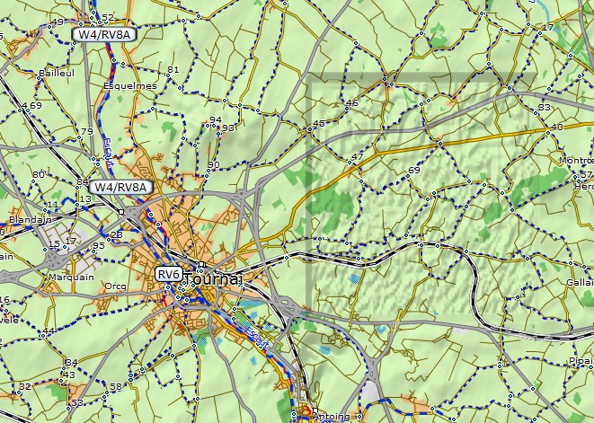
Hi Minko, I can reproduce the wrong data with your file with just --dem-dists=26512 @Frank: I've written the attached data with the attached patch. Hope you can extract the values you need. Gerd ________________________________________ Von: mkgmap-dev <mkgmap-dev-bounces@lists.mkgmap.org.uk> im Auftrag von lig fietser <ligfietser@hotmail.com> Gesendet: Samstag, 13. Januar 2018 15:35:17 An: mkgmap-dev@lists.mkgmap.org.uk Betreff: Re: [mkgmap-dev] mkgmap r4048 seems to fix problem with hill shading Hi, Unfortunately older mkgmap versions showed the same behaviour, only smaller grey tiles. I've noticed that my other Germany Benelux map from last week had similar issue, only those greay tiles were not so big as in the video. Now I have tested 4048 again but with slithly modified dem distances. That grey area seems gone, but I got something weird in return 😉 see attachment. It seems all happening in the same area, around Tournai. I've uploaded this tile here http://mijndev.openstreetmap.nl/~ligfietser/mkgmap/ My values are now: dem-dists: 3312,3312,9936,13248,26512 overview-dem-dist=88368 ________________________________ Van: mkgmap-dev <mkgmap-dev-bounces@lists.mkgmap.org.uk> namens Frank Stinner <Frank.Stinner@kabelmail.de> Verzonden: zaterdag 13 januari 2018 05:09:35 Aan: mkgmap-dev@lists.mkgmap.org.uk Onderwerp: Re: [mkgmap-dev] mkgmap r4048 seems to fix problem with hill shading Hi Gerd, yes, at first we have to identify the maptile. Perhaps can Minko help. Thats a "trial and error" play. Perhaps with comment out in areas.list? You ask for the input format? It's an ordinary textfile. One text-line for one data-line. The values in a line are separated by space, comma, semicolon or tab. If this file have q.e. 200 x 150 values, create BuildDEMFile 3 x 4 DEM-Tiles. As next i extract with the simple perl-script extracttiles.pl a range of tiles, encode this whith BuildDEMFile --dem="%TESTMAPDIR%\Product1\99950001\99950001.DEM" -O --data=dem.data --lastcolstd=false --left=0 --top=0.999991893768310546875 --dlon=0.0003 --dlat=0.0003 and see on the testmap 99950001.osm, what's going on. It's only "trial and error". Frank --- Diese E-Mail wurde von Avast Antivirus-Software auf Viren geprüft. https://www.avast.com/antivirus
Hi Frank, I've compared results from mkgmap with those from BuildDEMFile. Both produce different errors, so that should help. See http://files.mkgmap.org.uk/download/391/baddem3.zip The script produces a gmap folder with two different DEM files, 63240001_2.DEM is from BuildDEMFile and seems to do more harm ;-) Gerd ________________________________________ Von: mkgmap-dev <mkgmap-dev-bounces@lists.mkgmap.org.uk> im Auftrag von Gerd Petermann <gpetermann_muenchen@hotmail.com> Gesendet: Samstag, 13. Januar 2018 16:33:31 An: Development list for mkgmap Betreff: Re: [mkgmap-dev] mkgmap r4048 seems to fix problem with hill shading Hi Minko, I can reproduce the wrong data with your file with just --dem-dists=26512 @Frank: I've written the attached data with the attached patch. Hope you can extract the values you need. Gerd ________________________________________ Von: mkgmap-dev <mkgmap-dev-bounces@lists.mkgmap.org.uk> im Auftrag von lig fietser <ligfietser@hotmail.com> Gesendet: Samstag, 13. Januar 2018 15:35:17 An: mkgmap-dev@lists.mkgmap.org.uk Betreff: Re: [mkgmap-dev] mkgmap r4048 seems to fix problem with hill shading Hi, Unfortunately older mkgmap versions showed the same behaviour, only smaller grey tiles. I've noticed that my other Germany Benelux map from last week had similar issue, only those greay tiles were not so big as in the video. Now I have tested 4048 again but with slithly modified dem distances. That grey area seems gone, but I got something weird in return 😉 see attachment. It seems all happening in the same area, around Tournai. I've uploaded this tile here http://mijndev.openstreetmap.nl/~ligfietser/mkgmap/ My values are now: dem-dists: 3312,3312,9936,13248,26512 overview-dem-dist=88368 ________________________________ Van: mkgmap-dev <mkgmap-dev-bounces@lists.mkgmap.org.uk> namens Frank Stinner <Frank.Stinner@kabelmail.de> Verzonden: zaterdag 13 januari 2018 05:09:35 Aan: mkgmap-dev@lists.mkgmap.org.uk Onderwerp: Re: [mkgmap-dev] mkgmap r4048 seems to fix problem with hill shading Hi Gerd, yes, at first we have to identify the maptile. Perhaps can Minko help. Thats a "trial and error" play. Perhaps with comment out in areas.list? You ask for the input format? It's an ordinary textfile. One text-line for one data-line. The values in a line are separated by space, comma, semicolon or tab. If this file have q.e. 200 x 150 values, create BuildDEMFile 3 x 4 DEM-Tiles. As next i extract with the simple perl-script extracttiles.pl a range of tiles, encode this whith BuildDEMFile --dem="%TESTMAPDIR%\Product1\99950001\99950001.DEM" -O --data=dem.data --lastcolstd=false --left=0 --top=0.999991893768310546875 --dlon=0.0003 --dlat=0.0003 and see on the testmap 99950001.osm, what's going on. It's only "trial and error". Frank --- Diese E-Mail wurde von Avast Antivirus-Software auf Viren geprüft. https://www.avast.com/antivirus
I think I found the bug. The tile contains negative heights (~170m) and this causes trouble in the calculation of the needed bytes to store the height. See http://www.mkgmap.org.uk/websvn/revision.php?repname=mkgmap&rev=4051 Gerd ________________________________________ Von: mkgmap-dev <mkgmap-dev-bounces@lists.mkgmap.org.uk> im Auftrag von Gerd Petermann <gpetermann_muenchen@hotmail.com> Gesendet: Samstag, 13. Januar 2018 16:57:04 An: Development list for mkgmap Betreff: Re: [mkgmap-dev] mkgmap r4048 seems to fix problem with hill shading Hi Frank, I've compared results from mkgmap with those from BuildDEMFile. Both produce different errors, so that should help. See http://files.mkgmap.org.uk/download/391/baddem3.zip The script produces a gmap folder with two different DEM files, 63240001_2.DEM is from BuildDEMFile and seems to do more harm ;-) Gerd ________________________________________ Von: mkgmap-dev <mkgmap-dev-bounces@lists.mkgmap.org.uk> im Auftrag von Gerd Petermann <gpetermann_muenchen@hotmail.com> Gesendet: Samstag, 13. Januar 2018 16:33:31 An: Development list for mkgmap Betreff: Re: [mkgmap-dev] mkgmap r4048 seems to fix problem with hill shading Hi Minko, I can reproduce the wrong data with your file with just --dem-dists=26512 @Frank: I've written the attached data with the attached patch. Hope you can extract the values you need. Gerd ________________________________________ Von: mkgmap-dev <mkgmap-dev-bounces@lists.mkgmap.org.uk> im Auftrag von lig fietser <ligfietser@hotmail.com> Gesendet: Samstag, 13. Januar 2018 15:35:17 An: mkgmap-dev@lists.mkgmap.org.uk Betreff: Re: [mkgmap-dev] mkgmap r4048 seems to fix problem with hill shading Hi, Unfortunately older mkgmap versions showed the same behaviour, only smaller grey tiles. I've noticed that my other Germany Benelux map from last week had similar issue, only those greay tiles were not so big as in the video. Now I have tested 4048 again but with slithly modified dem distances. That grey area seems gone, but I got something weird in return 😉 see attachment. It seems all happening in the same area, around Tournai. I've uploaded this tile here http://mijndev.openstreetmap.nl/~ligfietser/mkgmap/ My values are now: dem-dists: 3312,3312,9936,13248,26512 overview-dem-dist=88368 ________________________________ Van: mkgmap-dev <mkgmap-dev-bounces@lists.mkgmap.org.uk> namens Frank Stinner <Frank.Stinner@kabelmail.de> Verzonden: zaterdag 13 januari 2018 05:09:35 Aan: mkgmap-dev@lists.mkgmap.org.uk Onderwerp: Re: [mkgmap-dev] mkgmap r4048 seems to fix problem with hill shading Hi Gerd, yes, at first we have to identify the maptile. Perhaps can Minko help. Thats a "trial and error" play. Perhaps with comment out in areas.list? You ask for the input format? It's an ordinary textfile. One text-line for one data-line. The values in a line are separated by space, comma, semicolon or tab. If this file have q.e. 200 x 150 values, create BuildDEMFile 3 x 4 DEM-Tiles. As next i extract with the simple perl-script extracttiles.pl a range of tiles, encode this whith BuildDEMFile --dem="%TESTMAPDIR%\Product1\99950001\99950001.DEM" -O --data=dem.data --lastcolstd=false --left=0 --top=0.999991893768310546875 --dlon=0.0003 --dlat=0.0003 and see on the testmap 99950001.osm, what's going on. It's only "trial and error". Frank --- Diese E-Mail wurde von Avast Antivirus-Software auf Viren geprüft. https://www.avast.com/antivirus _______________________________________________ mkgmap-dev mailing list mkgmap-dev@lists.mkgmap.org.uk http://www.mkgmap.org.uk/mailman/listinfo/mkgmap-dev
Hi, I still observe the first problem with small rectangles without shading. But I see it only when displaying small islands on a see. Like for example Príncipe Island or Ascension Island. Could it be, that processing sea level or voids around island could cause similar effects like polygon border? All my maps are currently compiled with patched mkgmap, I can't tell if original mkgmap shows this effect too. -- Best regards, Andrzej
Hi Andrzej, could not reproduce that yet. Please post tile boundaries and dem options in use. Gerd ________________________________________ Von: mkgmap-dev <mkgmap-dev-bounces@lists.mkgmap.org.uk> im Auftrag von Andrzej Popowski <popej@poczta.onet.pl> Gesendet: Samstag, 20. Januar 2018 02:15:58 An: mkgmap-dev@lists.mkgmap.org.uk Betreff: Re: [mkgmap-dev] mkgmap r4048 seems to fix problem with hill shading Hi, I still observe the first problem with small rectangles without shading. But I see it only when displaying small islands on a see. Like for example Príncipe Island or Ascension Island. Could it be, that processing sea level or voids around island could cause similar effects like polygon border? All my maps are currently compiled with patched mkgmap, I can't tell if original mkgmap shows this effect too. -- Best regards, Andrzej _______________________________________________ mkgmap-dev mailing list mkgmap-dev@lists.mkgmap.org.uk http://www.mkgmap.org.uk/mailman/listinfo/mkgmap-dev
Hi Andrzej, found problems now when I zoom into area around S7.93698 W14.30256 Gerd ________________________________________ Von: mkgmap-dev <mkgmap-dev-bounces@lists.mkgmap.org.uk> im Auftrag von Gerd Petermann <gpetermann_muenchen@hotmail.com> Gesendet: Montag, 22. Januar 2018 15:21:29 An: Development list for mkgmap Betreff: Re: [mkgmap-dev] mkgmap r4048 seems to fix problem with hill shading Hi Andrzej, could not reproduce that yet. Please post tile boundaries and dem options in use. Gerd ________________________________________ Von: mkgmap-dev <mkgmap-dev-bounces@lists.mkgmap.org.uk> im Auftrag von Andrzej Popowski <popej@poczta.onet.pl> Gesendet: Samstag, 20. Januar 2018 02:15:58 An: mkgmap-dev@lists.mkgmap.org.uk Betreff: Re: [mkgmap-dev] mkgmap r4048 seems to fix problem with hill shading Hi, I still observe the first problem with small rectangles without shading. But I see it only when displaying small islands on a see. Like for example Príncipe Island or Ascension Island. Could it be, that processing sea level or voids around island could cause similar effects like polygon border? All my maps are currently compiled with patched mkgmap, I can't tell if original mkgmap shows this effect too. -- Best regards, Andrzej _______________________________________________ mkgmap-dev mailing list mkgmap-dev@lists.mkgmap.org.uk http://www.mkgmap.org.uk/mailman/listinfo/mkgmap-dev _______________________________________________ mkgmap-dev mailing list mkgmap-dev@lists.mkgmap.org.uk http://www.mkgmap.org.uk/mailman/listinfo/mkgmap-dev
Hi all, I find similar problems when I create DEM with BuildDEMFile. I've created a package with latest mkgmap and BuildDEMFile. DEM are very different because mkgmap assumes height 0 for missing hgt files while BuildDEMFile writes invalid height. Both show similar problems, but not exactly the same. In Mapsource one has to select detail level medium, zoom out with Strg + "-", goto S7.93698 W14.30256 with Strg+T , then zoom in several times until scale shows 500m. Parts of the hill shading disappears. The exact position may change when you clear cache with 2x Strg+G . This is the result produced with r4073. If you stop MapSource, rename map\OSM map.gmap\Product1\63240001\63240001_2.DEM" to replace map\OSM map.gmap\Product1\63240001\63240001.DEM and start MapSource again and clear the cache, zoom out again, go to the same position you'll find empty part on the left at zoom level 300m. This is the DEM created by BuildDEMFile. @Frank: This looks like an error in the DEM data to me. Gerd ________________________________________ Von: mkgmap-dev <mkgmap-dev-bounces@lists.mkgmap.org.uk> im Auftrag von Gerd Petermann <gpetermann_muenchen@hotmail.com> Gesendet: Montag, 22. Januar 2018 15:25:55 An: Development list for mkgmap Betreff: Re: [mkgmap-dev] mkgmap r4048 seems to fix problem with hill shading Hi Andrzej, found problems now when I zoom into area around S7.93698 W14.30256 Gerd ________________________________________ Von: mkgmap-dev <mkgmap-dev-bounces@lists.mkgmap.org.uk> im Auftrag von Gerd Petermann <gpetermann_muenchen@hotmail.com> Gesendet: Montag, 22. Januar 2018 15:21:29 An: Development list for mkgmap Betreff: Re: [mkgmap-dev] mkgmap r4048 seems to fix problem with hill shading Hi Andrzej, could not reproduce that yet. Please post tile boundaries and dem options in use. Gerd ________________________________________ Von: mkgmap-dev <mkgmap-dev-bounces@lists.mkgmap.org.uk> im Auftrag von Andrzej Popowski <popej@poczta.onet.pl> Gesendet: Samstag, 20. Januar 2018 02:15:58 An: mkgmap-dev@lists.mkgmap.org.uk Betreff: Re: [mkgmap-dev] mkgmap r4048 seems to fix problem with hill shading Hi, I still observe the first problem with small rectangles without shading. But I see it only when displaying small islands on a see. Like for example Príncipe Island or Ascension Island. Could it be, that processing sea level or voids around island could cause similar effects like polygon border? All my maps are currently compiled with patched mkgmap, I can't tell if original mkgmap shows this effect too. -- Best regards, Andrzej _______________________________________________ mkgmap-dev mailing list mkgmap-dev@lists.mkgmap.org.uk http://www.mkgmap.org.uk/mailman/listinfo/mkgmap-dev _______________________________________________ mkgmap-dev mailing list mkgmap-dev@lists.mkgmap.org.uk http://www.mkgmap.org.uk/mailman/listinfo/mkgmap-dev _______________________________________________ mkgmap-dev mailing list mkgmap-dev@lists.mkgmap.org.uk http://www.mkgmap.org.uk/mailman/listinfo/mkgmap-dev
Sorry, forgot to add the link: http://files.mkgmap.org.uk/download/405/baddem5.zip Gerd ________________________________________ Von: mkgmap-dev <mkgmap-dev-bounces@lists.mkgmap.org.uk> im Auftrag von Gerd Petermann <gpetermann_muenchen@hotmail.com> Gesendet: Montag, 22. Januar 2018 16:30:07 An: Development list for mkgmap Betreff: Re: [mkgmap-dev] mkgmap r4048 seems to fix problem with hill shading Hi all, I find similar problems when I create DEM with BuildDEMFile. I've created a package with latest mkgmap and BuildDEMFile. DEM are very different because mkgmap assumes height 0 for missing hgt files while BuildDEMFile writes invalid height. Both show similar problems, but not exactly the same. In Mapsource one has to select detail level medium, zoom out with Strg + "-", goto S7.93698 W14.30256 with Strg+T , then zoom in several times until scale shows 500m. Parts of the hill shading disappears. The exact position may change when you clear cache with 2x Strg+G . This is the result produced with r4073. If you stop MapSource, rename map\OSM map.gmap\Product1\63240001\63240001_2.DEM" to replace map\OSM map.gmap\Product1\63240001\63240001.DEM and start MapSource again and clear the cache, zoom out again, go to the same position you'll find empty part on the left at zoom level 300m. This is the DEM created by BuildDEMFile. @Frank: This looks like an error in the DEM data to me. Gerd ________________________________________ Von: mkgmap-dev <mkgmap-dev-bounces@lists.mkgmap.org.uk> im Auftrag von Gerd Petermann <gpetermann_muenchen@hotmail.com> Gesendet: Montag, 22. Januar 2018 15:25:55 An: Development list for mkgmap Betreff: Re: [mkgmap-dev] mkgmap r4048 seems to fix problem with hill shading Hi Andrzej, found problems now when I zoom into area around S7.93698 W14.30256 Gerd ________________________________________ Von: mkgmap-dev <mkgmap-dev-bounces@lists.mkgmap.org.uk> im Auftrag von Gerd Petermann <gpetermann_muenchen@hotmail.com> Gesendet: Montag, 22. Januar 2018 15:21:29 An: Development list for mkgmap Betreff: Re: [mkgmap-dev] mkgmap r4048 seems to fix problem with hill shading Hi Andrzej, could not reproduce that yet. Please post tile boundaries and dem options in use. Gerd ________________________________________ Von: mkgmap-dev <mkgmap-dev-bounces@lists.mkgmap.org.uk> im Auftrag von Andrzej Popowski <popej@poczta.onet.pl> Gesendet: Samstag, 20. Januar 2018 02:15:58 An: mkgmap-dev@lists.mkgmap.org.uk Betreff: Re: [mkgmap-dev] mkgmap r4048 seems to fix problem with hill shading Hi, I still observe the first problem with small rectangles without shading. But I see it only when displaying small islands on a see. Like for example Príncipe Island or Ascension Island. Could it be, that processing sea level or voids around island could cause similar effects like polygon border? All my maps are currently compiled with patched mkgmap, I can't tell if original mkgmap shows this effect too. -- Best regards, Andrzej _______________________________________________ mkgmap-dev mailing list mkgmap-dev@lists.mkgmap.org.uk http://www.mkgmap.org.uk/mailman/listinfo/mkgmap-dev _______________________________________________ mkgmap-dev mailing list mkgmap-dev@lists.mkgmap.org.uk http://www.mkgmap.org.uk/mailman/listinfo/mkgmap-dev _______________________________________________ mkgmap-dev mailing list mkgmap-dev@lists.mkgmap.org.uk http://www.mkgmap.org.uk/mailman/listinfo/mkgmap-dev _______________________________________________ mkgmap-dev mailing list mkgmap-dev@lists.mkgmap.org.uk http://www.mkgmap.org.uk/mailman/listinfo/mkgmap-dev
Hi, on my maps I use 4 layers of DEM. The problem with shading appears mostly, when using medium or low detail level in Mapsource, probably when Mapsource use layers with lower resolution. Pressing Ctrl-G shows overview map and I think it always display correct shading. Other peculiarity is that problem appears only at sea shores, I don't find it when viewing land area. -- Best regards, Andrzej
Hi, maybe we have to set a special flag when we write "no data" tiles (all heights 0m) with headers like this: Both mkgmap and BuildDEMFile write them. Gerd popej wrote
Hi,
on my maps I use 4 layers of DEM. The problem with shading appears mostly, when using medium or low detail level in Mapsource, probably when Mapsource use layers with lower resolution. Pressing Ctrl-G shows overview map and I think it always display correct shading.
Other peculiarity is that problem appears only at sea shores, I don't find it when viewing land area.
-- Best regards, Andrzej
_______________________________________________ mkgmap-dev mailing list
mkgmap-dev@.org
-- Sent from: http://gis.19327.n8.nabble.com/Mkgmap-Development-f5324443.html
Hmm, seems that part of my post got lost: --------- DEM Tile Header ------------------------------------------------------ | | Zoom level 0 Tile row 0 column 0 00000029 | 00 00 | data section: at offset 0x000000 0000002b | 00 | minimum (base) height: 0 0000002c | 00 00 | max height delta: 0 --------- DEM Tile Header ------------------------------------------------------ | | Zoom level 0 Tile row 0 column 1 0000002e | 00 00 | data section: at offset 0x000000 00000030 | 00 | minimum (base) height: 0 00000031 | 00 00 | max height delta: 0 Gerd ________________________________________ Von: mkgmap-dev <mkgmap-dev-bounces@lists.mkgmap.org.uk> im Auftrag von Gerd Petermann <gpetermann_muenchen@hotmail.com> Gesendet: Montag, 22. Januar 2018 16:52:34 An: mkgmap-dev@lists.mkgmap.org.uk Betreff: Re: [mkgmap-dev] mkgmap r4048 seems to fix problem with hill shading Hi, maybe we have to set a special flag when we write "no data" tiles (all heights 0m) with headers like this: Both mkgmap and BuildDEMFile write them. Gerd popej wrote
Hi,
on my maps I use 4 layers of DEM. The problem with shading appears mostly, when using medium or low detail level in Mapsource, probably when Mapsource use layers with lower resolution. Pressing Ctrl-G shows overview map and I think it always display correct shading.
Other peculiarity is that problem appears only at sea shores, I don't find it when viewing land area.
-- Best regards, Andrzej
_______________________________________________ mkgmap-dev mailing list
mkgmap-dev@.org
-- Sent from: http://gis.19327.n8.nabble.com/Mkgmap-Development-f5324443.html _______________________________________________ mkgmap-dev mailing list mkgmap-dev@lists.mkgmap.org.uk http://www.mkgmap.org.uk/mailman/listinfo/mkgmap-dev
Hi Gerd, I have looked at Adria Topo and there is the same problem with small islands. Maybe it is not mkgmap's fault? -- Best regards, Andrzej
Hi Andrzej, that's good to know. I also tried it with Adria Topo and found no such problems. Do you also see them in Basecamp? I do with the demo map in baddem5.zip. Maybe we can ask Garmin to fix that problem when it shows up with their map? Gerd ________________________________________ Von: mkgmap-dev <mkgmap-dev-bounces@lists.mkgmap.org.uk> im Auftrag von Andrzej Popowski <popej@poczta.onet.pl> Gesendet: Montag, 22. Januar 2018 18:24:36 An: mkgmap-dev@lists.mkgmap.org.uk Betreff: Re: [mkgmap-dev] mkgmap r4048 seems to fix problem with hill shading Hi Gerd, I have looked at Adria Topo and there is the same problem with small islands. Maybe it is not mkgmap's fault? -- Best regards, Andrzej _______________________________________________ mkgmap-dev mailing list mkgmap-dev@lists.mkgmap.org.uk http://www.mkgmap.org.uk/mailman/listinfo/mkgmap-dev
Hi Gerd, see example form BaseCamp: http://files.mkgmap.org.uk/download/406/at2.png I do some zooming in/out at it appears. -- Best regards, Andrzej
participants (5)
-
 Andrzej Popowski
 -
 Frank Stinner
 -
 Gerd Petermann
 -
Gerd Petermann
-
 lig fietser