
Hi, is there a way to include the overview map in the gmapsupp.img without having to run mkgmap another time? If I have, say, three map tiles and the corresponding ovm files: -rw-r--r-- 1 ralf users 13522944 Feb 17 22:55 10000001.img -rw-r--r-- 1 ralf users 16841216 Feb 17 22:55 10000002.img -rw-r--r-- 1 ralf users 19913728 Feb 17 22:55 10000003.img -rw-r--r-- 1 ralf users 768512 Feb 17 22:55 ovm_10000001.img -rw-r--r-- 1 ralf users 1009152 Feb 17 22:55 ovm_10000002.img -rw-r--r-- 1 ralf users 1336320 Feb 17 22:55 ovm_10000003.img and I combine all these into a gmapsupp.img, then the overview map is created as a seperate file but not included in the gmapsupp.img: $ mkgmap --gmapsupp --overview-mapname=OV --overview-mapnumber=99999999 1*img ovm*img produces: -rw-r--r-- 1 ralf users 50177024 Feb 20 17:04 gmapsupp.img -rw-r--r-- 1 ralf users 24064 Feb 20 17:04 OV.img -rw-r--r-- 1 ralf users 1132 Feb 20 17:04 OV.tdb The overview map is not in the gmapsupp.img: $ gmt -i gmapsupp.img gmt v0.8.186.801b CC BY-SA (C) 2011-2014 AP www.gmaptool.eu File: gmapsupp.img, length 50177024 Header: 20.02.2015 17:04:44, DSKIMG, XOR 00, V 0.00, Ms 0 Mapset: OSM street map Map length s-f CP prio PID FID name MAKEGMAP MPS 206 1 10000001 MPC 13462832 5 1252 25 1 6324 Description 10000002 MPC 16766155 5 1252 25 1 6324 Description 10000003 MPC 19826659 5 1252 25 1 6324 Description 00006324 SRT 932 1 Data MPS F: PID 1, FID 6324, family name V: OSM map set (0) Only after running mkgmap one more time it is included: $ mkgmap --gmapsupp --overview-mapname=OV --overview-mapnumber=99999999 1*img ovm*img OV.img $ gmt -i gmapsupp.img gmt v0.8.186.801b CC BY-SA (C) 2011-2014 AP www.gmaptool.eu File: gmapsupp.img, length 50199552 Header: 20.02.2015 17:06:25, DSKIMG, XOR 00, V 0.00, Ms 0 Mapset: OSM street map Map length s-f CP prio PID FID name MAKEGMAP MPS 258 1 10000001 MPC 13462832 5 1252 25 1 6324 Description 10000002 MPC 16766155 5 1252 25 1 6324 Description 10000003 MPC 19826659 5 1252 25 1 6324 Description 99999999 MPC 20371 3 1252 25 1 6324 Overview Map 00006324 SRT 932 1 Data MPS F: PID 1, FID 6324, family name V: OSM map set (0) It would be very handy to have the overview map in the gmapsupp.img after the first run. Is this possible?

Hi Ralf, my understanding is that no device supports the overview map. It is only used on the PC. Why would you want to have it in the gmapsupp? Gerd Ralf Kleineisel wrote
Hi,
is there a way to include the overview map in the gmapsupp.img without having to run mkgmap another time?
If I have, say, three map tiles and the corresponding ovm files:
-rw-r--r-- 1 ralf users 13522944 Feb 17 22:55 10000001.img -rw-r--r-- 1 ralf users 16841216 Feb 17 22:55 10000002.img -rw-r--r-- 1 ralf users 19913728 Feb 17 22:55 10000003.img -rw-r--r-- 1 ralf users 768512 Feb 17 22:55 ovm_10000001.img -rw-r--r-- 1 ralf users 1009152 Feb 17 22:55 ovm_10000002.img -rw-r--r-- 1 ralf users 1336320 Feb 17 22:55 ovm_10000003.img
and I combine all these into a gmapsupp.img, then the overview map is created as a seperate file but not included in the gmapsupp.img:
$ mkgmap --gmapsupp --overview-mapname=OV --overview-mapnumber=99999999 1*img ovm*img
produces:
-rw-r--r-- 1 ralf users 50177024 Feb 20 17:04 gmapsupp.img -rw-r--r-- 1 ralf users 24064 Feb 20 17:04 OV.img -rw-r--r-- 1 ralf users 1132 Feb 20 17:04 OV.tdb
The overview map is not in the gmapsupp.img:
$ gmt -i gmapsupp.img gmt v0.8.186.801b CC BY-SA (C) 2011-2014 AP www.gmaptool.eu
File: gmapsupp.img, length 50177024 Header: 20.02.2015 17:04:44, DSKIMG, XOR 00, V 0.00, Ms 0 Mapset: OSM street map
Map length s-f CP prio PID FID name MAKEGMAP MPS 206 1 10000001 MPC 13462832 5 1252 25 1 6324 Description 10000002 MPC 16766155 5 1252 25 1 6324 Description 10000003 MPC 19826659 5 1252 25 1 6324 Description 00006324 SRT 932 1
Data MPS F: PID 1, FID 6324, family name V: OSM map set (0)
Only after running mkgmap one more time it is included:
$ mkgmap --gmapsupp --overview-mapname=OV --overview-mapnumber=99999999 1*img ovm*img OV.img
$ gmt -i gmapsupp.img gmt v0.8.186.801b CC BY-SA (C) 2011-2014 AP www.gmaptool.eu
File: gmapsupp.img, length 50199552 Header: 20.02.2015 17:06:25, DSKIMG, XOR 00, V 0.00, Ms 0 Mapset: OSM street map
Map length s-f CP prio PID FID name MAKEGMAP MPS 258 1 10000001 MPC 13462832 5 1252 25 1 6324 Description 10000002 MPC 16766155 5 1252 25 1 6324 Description 10000003 MPC 19826659 5 1252 25 1 6324 Description 99999999 MPC 20371 3 1252 25 1 6324 Overview Map 00006324 SRT 932 1
Data MPS F: PID 1, FID 6324, family name V: OSM map set (0)
It would be very handy to have the overview map in the gmapsupp.img after the first run. Is this possible? _______________________________________________ mkgmap-dev mailing list
mkgmap-dev@.org
-- View this message in context: http://gis.19327.n5.nabble.com/Overview-map-in-gmapsupp-img-tp5834392p583440... Sent from the Mkgmap Development mailing list archive at Nabble.com.
On 02/20/2015 07:50 PM, GerdP wrote:
my understanding is that no device supports the overview map. It is only used on the PC. Why would you want to have it in the gmapsupp?
I am currently preparing a new update to my topo map of Germany. The level definition in my options file is: levels = 0:24, 1:23, 2:22, 3:20, 4:18 overview-levels = 5:16, 6:15, 7:14, 8:12 Without the overview map in the gmapsupp.img my eTrex Legend HCx displays only the yellow background and the tile borders ("no map") on all zoom levels down to 50 km. From 30 km onwards it displays the map tiles. When I load a gmapsupp.img with the overview map inside I get: 800 km - 200 km: White background, national borders, sea; "mapsource" 120 km - 80 km: E-Roads 50 km: Motorroads 30 km: Highway=primary and so on. To me this looks like the overview map is perfectly supported by this gps unit. Zooming and panning in the zoom levels above 30 km is much faster with an overview map. Without an overview map the 30 km zoom level shows much more (too much!) detail (forest, landuse etc.). With an overview map the forest is shown from 2 km onwards, like I set in the style. I can put both gmapsupp.img on my server if someone wants to have a look at it or test it on a different gps unit.
On 02/20/2015 08:30 PM, Ralf Kleineisel wrote:
On 02/20/2015 07:50 PM, GerdP wrote:
my understanding is that no device supports the overview map. It is only used on the PC. Why would you want to have it in the gmapsupp?
I am currently preparing a new update to my topo map of Germany.
I compared two gmapsupp.imgs made with exactly the same tiles now, only difference is the overview map. I could not reproduce the effect of "no map", probably the maps I tested earlier were not identical. But the overview map does make a huge difference in my eTrex: Zooming from 30km to 50km takes 95 seconds without an overview map and 6 seconds with one. Much less detail shows up with an overview map, without overview map the details shown does not match my style files.

Hi Ralf,
Without the overview map in the gmapsupp.img my eTrex Legend HCx displays only the yellow background and the tile borders ("no map") on all zoom levels down to 50 km. From 30 km onwards it displays the map tiles.
You probably have deleted or disabled in menu Garmin basemap. Please look for file gmapbmap.img in eTrex memory and if present, then enable Worldmap in device menu. If you miss gmapbmap.img, then you can copy this file form any other GPS. -- Best regards, Andrzej
Hi, On 02/20/2015 09:58 PM, Andrzej Popowski wrote:
You probably have deleted or disabled in menu Garmin basemap.
Interesting. Yes, the basemap was disabled. With a gmapsupp.img including an overview map: - No matter wether I enable or disable the basemap, I always see my map on all zoom levels as long as the gps cursor is inside my map area. - Depending on the zoom level I see my overview map or my detailed map tiles. - With the cursor outside the map area I see the basemap in all zoom levels. With a gmapsupp.img without an overview map: - When I enable the basemap I see my map in zoom levels 8km and below.
From 12 km and above I see the basemap.
- When I disable the basemap I see my detailed map tiles in zoom levels 120km and below. It shows way too much detail and it takes very long to draw the map. - With the cursor outside the map area I see the basemap in all zoom levels. Having an overview map in the gmapsupp.img seems to override the basemap.
Hi Ralf,
- When I enable the basemap I see my map in zoom levels 8km and below.
From 12 km and above I see the basemap.
- When I disable the basemap I see my detailed map tiles in zoom levels 120km and below. It shows way too much detail and it takes very long to draw the map.
That's how map is designed. Default definitions for levels in mkgmap is: --levels=0:24,1:22,2:20,3:18 This means, that last level has 18-bit resolution and is visible in zoom range 5-8km (this depends also on detail settings in device). Above these zoom GPS uses basemap. If you disable basemap, then you see last level from detailed map, which contains too many data to be displayed fast and clean. The proper solution for you would be to add more levels to detailed map. Try to use this option for mkgmap: --levels=0:24,1:22,2:20,3:18,4:16,5:14 This should include proper levels for zoom up to 120km. You can add even more levels, but probably at these levels map won't be better than basemap already present in GPS. -- Best regards, Andrzej
On 02/21/2015 12:35 PM, Andrzej Popowski wrote:
The proper solution for you would be to add more levels to detailed map.
What is the advantage of using more map tile levels instead of putting them into the overview map? I need the overview map for mapsource anyway. What's more, without overview map the gps has to dig through all the tiles to display the higher levels, with an overview map it has to open the overview map only.
Hi Ralf,
What is the advantage of using more map tile levels instead of putting them into the overview map?
This is a standard design, supported by mkgmap and Garmin tools. Yours is not, so you have to do some additional work. Isn't it the reason, for which you have started this thread? Have you tried a search for cities in eTrex? I think you can get double hits for cities present on overview map. -- Best regards, Andrzej
Hi all, I followed the discussion, but I am not sure about the results. My understanding so far: If you disable the basemap or if you don't like the basemap in the device you should either add the overview map to the gmapsupp file or use low resolution levels for each tile. I see no reason why we should not add the overview map to the gmapsupp if that is what the user wants and the device is working fine with it. Gerd
Date: Sat, 21 Feb 2015 15:44:45 +0100 From: popej@poczta.onet.pl To: mkgmap-dev@lists.mkgmap.org.uk Subject: Re: [mkgmap-dev] Overview map in gmapsupp.img?
Hi Ralf,
What is the advantage of using more map tile levels instead of putting them into the overview map?
This is a standard design, supported by mkgmap and Garmin tools. Yours is not, so you have to do some additional work. Isn't it the reason, for which you have started this thread?
Have you tried a search for cities in eTrex? I think you can get double hits for cities present on overview map.
-- Best regards, Andrzej _______________________________________________ mkgmap-dev mailing list mkgmap-dev@lists.mkgmap.org.uk http://www.mkgmap.org.uk/mailman/listinfo/mkgmap-dev
Hi, On 02/23/2015 08:57 AM, Gerd Petermann wrote:
My understanding so far: If you disable the basemap or if you don't like the basemap in the device you should either add the overview map to the gmapsupp file or use low resolution levels for each tile.
yes, both ways work on my eTrex Legend HCx.
Hi Gerd,
I see no reason why we should not add the overview map to the gmapsupp if that is what the user wants and the device is working fine with it.
There is no need to add overview to gmapsupp. It can be copied as a separate file to GPS with the same result. Or user can merge overview map and detailed maps to a single gmapsupp: mkgmap.jar --gmapsupp --index 1*.img overview.img The second version adds data from overview map into index search, which cause duplicated search results, see attached picture. I think both version will show duplicated cities when performing search near current position. I haven't checked thoroughly, but I have noticed a delay, when switching from detailed map to overview in GPS. I think single map with more levels could be faster. Summarizing: in my opinion this is not a proper way to create a map. If you add direct support for this procedure to mkgmap, you would give some kind of recommendation for it. And since it can be easily done without any changes to mkgmap, I would rather leave it as it is. -- Best regards, Andrzej

I'ld rather see a good OSM based worldmap (or simply based on other open sources if they prove to be better for use ) that we could use to exchange the basemap. Thinking about a map - usable both in Basecamp/Mapsource as well as on GPS Devices - 15-20MB in size - including ocean/land, big cities - maybe highway=motorway, big rivers, country borders... - Resolution maybe 16-14-12-10. (maybe create a version including indexed POIs (for desktop) - one without so it doesn't overlap the search). On 23 February 2015 at 13:06, Andrzej Popowski <popej@poczta.onet.pl> wrote:
Hi Gerd,
I see no reason why we should not add the overview map to the gmapsupp if that is what the user wants and the device is working fine with it.
There is no need to add overview to gmapsupp. It can be copied as a separate file to GPS with the same result. Or user can merge overview map and detailed maps to a single gmapsupp: mkgmap.jar --gmapsupp --index 1*.img overview.img
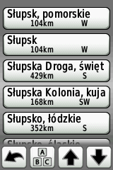
The second version adds data from overview map into index search, which cause duplicated search results, see attached picture. I think both version will show duplicated cities when performing search near current position.
I haven't checked thoroughly, but I have noticed a delay, when switching from detailed map to overview in GPS. I think single map with more levels could be faster.
Summarizing: in my opinion this is not a proper way to create a map. If you add direct support for this procedure to mkgmap, you would give some kind of recommendation for it. And since it can be easily done without any changes to mkgmap, I would rather leave it as it is.
-- Best regards, Andrzej
_______________________________________________ mkgmap-dev mailing list mkgmap-dev@lists.mkgmap.org.uk http://www.mkgmap.org.uk/mailman/listinfo/mkgmap-dev
-- Felix Hartman - Openmtbmap.org & VeloMap.org Floragasse 9/11 1040 Wien Austria - Österreich
participants (5)
-
 Andrzej Popowski
 -
 Felix Hartmann
 -
 Gerd Petermann
 -
GerdP
-
 Ralf Kleineisel