mkgmap splitter or mkgmap leave out information on luxembourg.osm.pbf from geofabrik

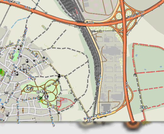
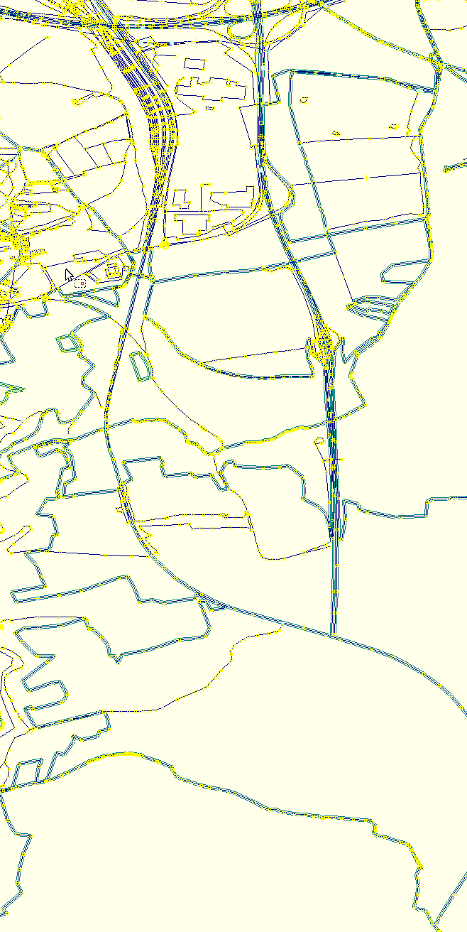
See the following screenshots - map vs josm - look at the highway junction both times on the top as a reference. There is about 1km missing - I really cannot understand how and why this happens.. (and not there is no related error message or missing tile), in the east of luxembourg, mkgmap also cuts away a bit.: -- keep on biking and discovering new trails Felix openmtbmap.org & www.velomap.org
Well, I tried to render luxembourg using the osm.pbf file from geofabrik, without splitting it, and than the map is good. As soon as I split it (also if the output is only one single osm.pbf tile), I have missing portions in the map. I use the following commands for splitting (newest splitter): java -Xms4000m -Xmx6800m -jar splitter.jar --max-nodes=1250000 --output=pbf --overlap=5000 --geonames-file=cities15000 --description=luxembourg --mapid=64230000 luxembourg.osm.pbf And this is the splitter output: cache= description=luxembourg geonames-file=cities15000 legacy-mode=false mapid=64230000 max-areas=255 max-nodes=1250000 max-threads=8 (auto) mixed=false no-trim=false output=pbf output-dir= overlap=5000 resolution=13 split-file= status-freq=120 write-kml= Elapsed time: 0s Memory: Current 3833MB (20MB used, 3813MB free) Max 6044MB Time started: Wed Oct 17 13:18:08 CEST 2012 Map is being split for resolution 13: - area boundaries are aligned to 0x800 map units - areas are multiples of 0x1000 map units wide and high Processing c:\openmtbmap\osmpbf_geofabrik\luxembourg.osm.pbf Bounding box 5.733033000000001 49.445530000000005 6.532249 50.184960000000004 in 1 file Time: Wed Oct 17 13:18:09 CEST 2012 Exact map coverage is (49.44551467895508,5.733017921447754) to (50.184946060180664,6.532230377197266) Trimmed and rounded map coverage is (49.482421875,5.712890625) to (50.185546875,6.50390625) Splitting nodes into areas containing a maximum of 1'250'000 nodes each... Area (49.482421875,5.712890625) to (50.185546875,6.50390625) contains 997'119 nodes. DONE! 1 areas: Area 64230000 covers (0x233000,0x41000) to (0x23b000,0x4a000) LU-Luxembourg Writing out split osm files Wed Oct 17 13:18:09 CEST 2012 Processing 1 areas in a single pass (49.482421875,5.712890625) to (50.185546875,6.50390625) Starting pass 1 of 1, processing 1 areas (64230000 to 64230000) Grid [512][512] for grid area (49.3751335144043,5.605602264404297) to (50.2928352355957,6.611194610595703) requires max. 1 checks for each no Grid was created in 62 ms Allocating three-tier structure to save area info (HashMap->vector->chunkvector) Allocating three-tier structure to save area info (HashMap->vector->chunkvector) Processing c:\openmtbmap\osmpbf_geofabrik\luxembourg.osm.pbf Bounding box 5.733033000000001 49.445530000000005 6.532249 50.184960000000004 MAP occupancy: 1'000'000, number of area dictionary entries: 1 of 65535 Map details: HashMap -> 7 vectors for 88'816 chunks(vector usage < 1%) Writing ways Wed Oct 17 13:18:11 CEST 2012 Writing relations Wed Oct 17 13:18:13 CEST 2012 *********************************************************** Final statistics *********************************************************** Needed dictionary entries: 1 of 65535 coords occupancy MAP occupancy: 1'036'326 Length-6 chunks: 91'338 (Bytes: 2'192'112) Length-10 chunks: 0 (Bytes: 0) Length-14 chunks: 0 (Bytes: 0) Length-18 chunks: 0 (Bytes: 0) Length-22 chunks: 0 (Bytes: 0) Length-26 chunks: 0 (Bytes: 0) Length-30 chunks: 0 (Bytes: 0) Length-34 chunks: 0 (Bytes: 0) Length-38 chunks: 0 (Bytes: 0) Length-42 chunks: 0 (Bytes: 0) Length-46 chunks: 0 (Bytes: 0) Length-50 chunks: 0 (Bytes: 0) Length-54 chunks: 0 (Bytes: 0) Length-58 chunks: 0 (Bytes: 0) Length-62 chunks: 0 (Bytes: 0) Length-66 chunks: 0 (Bytes: 0) Length-68 chunks: 0 (Bytes: 0) RLE compresion info: compressed / uncompressed size / ratio: 548'028 / 1'526'290 / 65% Map details: HashMap -> 8 vectors for 91'338 chunks(vector usage < 1%) ways occupancy MAP occupancy: 103'579 Length-6 chunks: 29'433 (Bytes: 706'392) Length-10 chunks: 0 (Bytes: 0) Length-14 chunks: 0 (Bytes: 0) Length-18 chunks: 0 (Bytes: 0) Length-22 chunks: 0 (Bytes: 0) Length-26 chunks: 0 (Bytes: 0) Length-30 chunks: 0 (Bytes: 0) Length-34 chunks: 0 (Bytes: 0) Length-38 chunks: 0 (Bytes: 0) Length-42 chunks: 0 (Bytes: 0) Length-46 chunks: 0 (Bytes: 0) Length-50 chunks: 0 (Bytes: 0) Length-54 chunks: 0 (Bytes: 0) Length-58 chunks: 0 (Bytes: 0) Length-62 chunks: 0 (Bytes: 0) Length-66 chunks: 0 (Bytes: 0) Length-68 chunks: 0 (Bytes: 0) RLE compresion info: compressed / uncompressed size / ratio: 176'598 / 254'588 / 31% Map details: HashMap -> 1 vectors for 29'433 chunks(vector usage < 2%) Thread worker-3 has finished Thread worker-2 has finished Thread worker-5 has finished Thread worker-4 has finished Thread worker-6 has finished Thread worker-0 has finished Thread worker-1 has finished Time finished: Wed Oct 17 13:18:13 CEST 2012 Total time taken: 5s On 17.10.2012 12:54, Felix Hartmann wrote:
See the following screenshots - map vs josm - look at the highway junction both times on the top as a reference. There is about 1km missing - I really cannot understand how and why this happens.. (and not there is no related error message or missing tile), in the east of luxembourg, mkgmap also cuts away a bit.:
-- keep on biking and discovering new trails
Felix openmtbmap.org &www.velomap.org
-- keep on biking and discovering new trails Felix openmtbmap.org & www.velomap.org

Hi Felix,
Exact map coverage is (49.44551467895508,5.733017921447754) to (50.184946060180664,6.532230377197266) Trimmed and rounded map coverage is (49.482421875,5.712890625) to (50.185546875,6.50390625)
I think the reason is that splitter writes a different bounding box to the file. I am not sure, but it seems to be an error in RoundingUtils.java: int roundedMinLon = roundDown(b.getMinLong(), shift); int roundedMaxLon = roundDown(b.getMaxLong(), shift); Both the min and the max value are rounded down. This looks wrong. Similar problem with the latitude values: int roundedMinLat = roundUp(minLat, shift); int roundedMaxLat = roundUp(maxLat, shift); Ciao, Gerd -- View this message in context: http://gis.19327.n5.nabble.com/mkgmap-splitter-or-mkgmap-leave-out-informati... Sent from the Mkgmap Development mailing list archive at Nabble.com.

I think this was discussed some time ago: http://www.mkgmap.org.uk/pipermail/mkgmap-dev/2011q3/012193.html WanMil
Hi Felix,
Exact map coverage is (49.44551467895508,5.733017921447754) to (50.184946060180664,6.532230377197266) Trimmed and rounded map coverage is (49.482421875,5.712890625) to (50.185546875,6.50390625)
I think the reason is that splitter writes a different bounding box to the file. I am not sure, but it seems to be an error in RoundingUtils.java:
int roundedMinLon = roundDown(b.getMinLong(), shift); int roundedMaxLon = roundDown(b.getMaxLong(), shift);
Both the min and the max value are rounded down. This looks wrong. Similar problem with the latitude values: int roundedMinLat = roundUp(minLat, shift); int roundedMaxLat = roundUp(maxLat, shift);
Ciao, Gerd
-- View this message in context: http://gis.19327.n5.nabble.com/mkgmap-splitter-or-mkgmap-leave-out-informati... Sent from the Mkgmap Development mailing list archive at Nabble.com. _______________________________________________ mkgmap-dev mailing list mkgmap-dev@lists.mkgmap.org.uk http://www.mkgmap.org.uk/mailman/listinfo/mkgmap-dev
Actually the way I put the rounding now (to include everything) - is the way it has been up to rev 104, then came rev105 and the change (28.1.2010) - the patch did the same thing as I did. However actually now that I think about it - I can only come up with one explication why rev 105 on splitter was done - that is so that tiles don't overlap. Because the current hack means all tiles will be expanded. What we really need is to have the splitter identify ALL outside edges. Only on outside edges it shall do as I wrote lower down, on edges to the inside rev 105 is the way to go. So can anyone code that in? On 17.10.2012 20:23, WanMil wrote:
I think this was discussed some time ago: http://www.mkgmap.org.uk/pipermail/mkgmap-dev/2011q3/012193.html
WanMil
Hi Felix,
Exact map coverage is (49.44551467895508,5.733017921447754) to (50.184946060180664,6.532230377197266) Trimmed and rounded map coverage is (49.482421875,5.712890625) to (50.185546875,6.50390625) I think the reason is that splitter writes a different bounding box to the file. I am not sure, but it seems to be an error in RoundingUtils.java:
int roundedMinLon = roundDown(b.getMinLong(), shift); int roundedMaxLon = roundDown(b.getMaxLong(), shift);
Both the min and the max value are rounded down. This looks wrong. Similar problem with the latitude values: int roundedMinLat = roundUp(minLat, shift); int roundedMaxLat = roundUp(maxLat, shift);
Ciao, Gerd
-- View this message in context: http://gis.19327.n5.nabble.com/mkgmap-splitter-or-mkgmap-leave-out-informati... Sent from the Mkgmap Development mailing list archive at Nabble.com. _______________________________________________ mkgmap-dev mailing list mkgmap-dev@lists.mkgmap.org.uk http://www.mkgmap.org.uk/mailman/listinfo/mkgmap-dev
_______________________________________________ mkgmap-dev mailing list mkgmap-dev@lists.mkgmap.org.uk http://www.mkgmap.org.uk/mailman/listinfo/mkgmap-dev
-- keep on biking and discovering new trails Felix openmtbmap.org & www.velomap.org

On 17/10/12 19:44, Felix Hartmann wrote:
However actually now that I think about it - I can only come up with one explication why rev 105 on splitter was done - that is so that tiles don't overlap. Because the current hack means all tiles will be expanded.
Yes, that is exactly right, the tiles will overlap and routing will fail across boundaries.
What we really need is to have the splitter identify ALL outside edges.
Yes. I'm not really sure how splitter works now, but it looks to me like all we need to do is alter SplittableArea splittableArea = nodes.getRoundedArea(resolution); in Main.calculateAreas() so that it doesn't round at all. ..Steve
Hi, I'll take a look at it. Gerd
Date: Wed, 17 Oct 2012 23:00:54 +0100 From: steve@parabola.me.uk To: extremecarver@gmail.com; mkgmap-dev@lists.mkgmap.org.uk Subject: Re: [mkgmap-dev] It's clearly a bug in the splitter
On 17/10/12 19:44, Felix Hartmann wrote:
However actually now that I think about it - I can only come up with one explication why rev 105 on splitter was done - that is so that tiles don't overlap. Because the current hack means all tiles will be expanded.
Yes, that is exactly right, the tiles will overlap and routing will fail across boundaries.
What we really need is to have the splitter identify ALL outside edges.
Yes.
I'm not really sure how splitter works now, but it looks to me like all we need to do is alter
SplittableArea splittableArea = nodes.getRoundedArea(resolution);
in Main.calculateAreas() so that it doesn't round at all.
..Steve _______________________________________________ mkgmap-dev mailing list mkgmap-dev@lists.mkgmap.org.uk http://www.mkgmap.org.uk/mailman/listinfo/mkgmap-dev
On 17.10.2012 18:01, GerdP wrote:
int roundedMinLon = roundDown(b.getMinLong(), shift); int roundedMaxLon = roundDown(b.getMaxLong(), shift);
Both the min and the max value are rounded down. This looks wrong. Similar problem with the latitude values: int roundedMinLat = roundUp(minLat, shift); int roundedMaxLat = roundUp(maxLat, shift);
thanks, I changed it to the following - and now it works. I think someone should have a look at it, and check it in, as it makes much more sense.... int roundedMinLon = roundDown(b.getMinLong(), shift); int roundedMaxLon = round*Up*(b.getMaxLong(), shift); int roundedMinLat = round*Down*(minLat, shift); int roundedMaxLat = roundUp(maxLat, shift); -- keep on biking and discovering new trails Felix openmtbmap.org & www.velomap.org

Hi Felix I have encountered similar problems when splitter only produces one pbf file - see previous posting about tdb & mdr issues Have you tried reducing the max-nodes to obtain 2 pbfs - that seems to do the trick with me /nick -- View this message in context: http://gis.19327.n5.nabble.com/mkgmap-splitter-or-mkgmap-leave-out-informati... Sent from the Mkgmap Development mailing list archive at Nabble.com.
On 17.10.2012 17:10, n Willink wrote:
Hi Felix I have encountered similar problems when splitter only produces one pbf file - see previous posting about tdb & mdr issues
Have you tried reducing the max-nodes to obtain 2 pbfs - that seems to do the trick with me
/nick yes doesn't change anything. On Luxembourg the output is exactly the same. There is some really serious bug in the splitter. Also --no-trim changes absolutely nothing.
participants (6)
-
 Felix Hartmann
 -
 Gerd Petermann
 -
GerdP
-
 n Willink
 -
 Steve Ratcliffe
 -
 WanMil