Minimum size for a "_link" to process "destination"

Hi mkgmap developers, I noticed that when a "_link" containing the tag "destination" (trunk_link, for example) is too small, mkgmap doesn't preprocesse the exit (set dest_hint). For example, if this "_link" has only 8 meters size, no destination nor exit hint is generated by mkgmap for this specific "_link". Could you tell me the "_exit" minimum lenght considered by mkgmap to process destination hint? Thanks. Best regards, Alexandre Loss

Hi ALexandre, I did not write the code but I think this snippet in LinkDestinationHook.java answers the question: if (wayLength < 10 && w.getPoints().size() < 3) { log.info("Way", w, "is too short (", wayLength," m) to cut it into several pieces. Cannot place exit hint."); continue; } I must confess that I don't understand this limit, maybe it was introduced to avoid zig-zagging lines, maybe Garmin ignores ways which are too short. Gerd ________________________________ Von: mkgmap-dev <mkgmap-dev-bounces@lists.mkgmap.org.uk> im Auftrag von Alexandre Loss <alexandre.loss@gmail.com> Gesendet: Mittwoch, 9. März 2016 17:55 An: Development list for mkgmap Betreff: [mkgmap-dev] Minimum size for a "_link" to process "destination" Hi mkgmap developers, I noticed that when a "_link" containing the tag "destination" (trunk_link, for example) is too small, mkgmap doesn't preprocesse the exit (set dest_hint). For example, if this "_link" has only 8 meters size, no destination nor exit hint is generated by mkgmap for this specific "_link". Could you tell me the "_exit" minimum lenght considered by mkgmap to process destination hint? Thanks. Best regards, Alexandre Loss
Yes Gerd, this probably answer the question. I'll do a practical test with length around 10 meters and share with you know the results. Thanks Alexandre Enviado do meu iPhone
Em 9 de mar de 2016, às 15:40, Gerd Petermann <GPetermann_muenchen@hotmail.com> escreveu:
Hi ALexandre,
I did not write the code but I think this snippet in LinkDestinationHook.java answers the question:
if (wayLength < 10 && w.getPoints().size() < 3) { log.info("Way", w, "is too short (", wayLength," m) to cut it into several pieces. Cannot place exit hint."); continue; }
I must confess that I don't understand this limit, maybe it was introduced to avoid zig-zagging lines, maybe Garmin ignores
ways which are too short.
Gerd
Von: mkgmap-dev <mkgmap-dev-bounces@lists.mkgmap.org.uk> im Auftrag von Alexandre Loss <alexandre.loss@gmail.com> Gesendet: Mittwoch, 9. März 2016 17:55 An: Development list for mkgmap Betreff: [mkgmap-dev] Minimum size for a "_link" to process "destination"
Hi mkgmap developers,
I noticed that when a "_link" containing the tag "destination" (trunk_link, for example) is too small, mkgmap doesn't preprocesse the exit (set dest_hint). For example, if this "_link" has only 8 meters size, no destination nor exit hint is generated by mkgmap for this specific "_link".
Could you tell me the "_exit" minimum lenght considered by mkgmap to process destination hint?
Thanks.
Best regards,
Alexandre Loss _______________________________________________ mkgmap-dev mailing list mkgmap-dev@lists.mkgmap.org.uk http://www.mkgmap.org.uk/mailman/listinfo/mkgmap-dev

Hi Gerd,
maybe Garmin ignores ways which are too short.
cGPSmapper has restriction for minimum distance between routing nodes, which is about 2.4m. Maybe there is some a reason for it? I guess splitting link is some kind of solution to get 2 ways and 3 nodes for a hint, but actually it should be main road and a link as 2 ways. If main road is oneway, then maybe you could use it instead of splitting link? -- Best regards, Andrzej
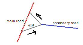
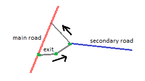
Hi Gerd, I confirmed in practical tests that dest_hint began to be generated with link of at least 10 meters. Hi Andrzej, I have many dest_hint working as a charm in links with only 2 nodes, also linking a main road to a secondary one, both two way. However, link must be oneway and at least 10m length (as discovered today). For now there is only one situation where I found that the link must be splitted. It is when the exit is over a link in "V". Let me explain better... 1. Suppose the following situation where you have a main road (red, don't care if oneway or not), a secondary road (blue) and a link (grey, oneway) with a exit/destination from main to secondary road. 2. However, the link is a way of 3 nodes, forming a "V": node 1 starting in main road; node 2 is the "V" bottom connecting the secondary road; and, node 3 is ending back in main road. [image: Imagem inline 2] Note that exit way linking main to secondary road is in fact a "leg" of the "V" with only two nodes. In this situation, the dest_hint doesn't work and I must splitte this "leg" of the link to have at least 3 nodes. Some thing like that: [image: Imagem inline 4] Splitting this way, the dest_hint works as expected. regards, Alexandre 2016-03-09 17:08 GMT-03:00 Andrzej Popowski <popej@poczta.onet.pl>:
Hi Gerd,
maybe Garmin ignores ways which are too short.
cGPSmapper has restriction for minimum distance between routing nodes, which is about 2.4m. Maybe there is some a reason for it?
I guess splitting link is some kind of solution to get 2 ways and 3 nodes for a hint, but actually it should be main road and a link as 2 ways. If main road is oneway, then maybe you could use it instead of splitting link?
-- Best regards, Andrzej
_______________________________________________ mkgmap-dev mailing list mkgmap-dev@lists.mkgmap.org.uk http://www.mkgmap.org.uk/mailman/listinfo/mkgmap-dev
Hi Alexandre, my first guess was, that mkgmap uses feature called in cGPSmapper "road sign". This works similar to restrictions and needs multiple legs to indicate road path associated with road sign. Now I rather think that destination hints are simply short legs of standard road inserted into road links. This configuration probably needs a link before inserted leg to generate required hint in GPS. That could be the reason for splitting links. I'm not sure, maybe someone can comment. -- Best regards, Andrzej

If I recall correctly, Garmins don't use the road name for links. Instead they use the name of the first non-link road, i.e. where the link leads to. So the first bit of the exit ramp stays as a link (road type 0x08 or 0x09), and a short bit in the middle gets the destination as a name, so the GPS will announce "take exit to Mytown". There may be more to it, but that is how I think it works. //colin On 2016-03-10 22:57, Andrzej Popowski wrote:
Hi Alexandre,
my first guess was, that mkgmap uses feature called in cGPSmapper "road sign". This works similar to restrictions and needs multiple legs to indicate road path associated with road sign.
Now I rather think that destination hints are simply short legs of standard road inserted into road links. This configuration probably needs a link before inserted leg to generate required hint in GPS. That could be the reason for splitting links. I'm not sure, maybe someone can comment.
Hi Andrzej, I did not notice the "Road sign" feature in cGPSmapper until now. Sounds like a nice alternative to the existing method in mkgmap, but someone has to find out how the road signs are encoded in the img format. Gerd ________________________________________ Von: mkgmap-dev <mkgmap-dev-bounces@lists.mkgmap.org.uk> im Auftrag von Andrzej Popowski <popej@poczta.onet.pl> Gesendet: Donnerstag, 10. März 2016 22:57 An: mkgmap-dev@lists.mkgmap.org.uk Betreff: Re: [mkgmap-dev] Minimum size for a "_link" to process "destination" Hi Alexandre, my first guess was, that mkgmap uses feature called in cGPSmapper "road sign". This works similar to restrictions and needs multiple legs to indicate road path associated with road sign. Now I rather think that destination hints are simply short legs of standard road inserted into road links. This configuration probably needs a link before inserted leg to generate required hint in GPS. That could be the reason for splitting links. I'm not sure, maybe someone can comment. -- Best regards, Andrzej _______________________________________________ mkgmap-dev mailing list mkgmap-dev@lists.mkgmap.org.uk http://www.mkgmap.org.uk/mailman/listinfo/mkgmap-dev
Hi Gerd, I can compile some simple examples but I have not much experience in img format to analyze them. -- Best regards, Andrzej
Hi Andrzej, Yes, I guess it would help if you compile two equal simple maps, one with and one without such a road sign. If there are different kinds of road signs try to repeat it for them. I'll see what our tools will tell me. Gerd ________________________________________ Von: mkgmap-dev <mkgmap-dev-bounces@lists.mkgmap.org.uk> im Auftrag von Andrzej Popowski <popej@poczta.onet.pl> Gesendet: Samstag, 12. März 2016 11:37 An: mkgmap-dev@lists.mkgmap.org.uk Betreff: Re: [mkgmap-dev] Minimum size for a "_link" to process "destination" Hi Gerd, I can compile some simple examples but I have not much experience in img format to analyze them. -- Best regards, Andrzej _______________________________________________ mkgmap-dev mailing list mkgmap-dev@lists.mkgmap.org.uk http://www.mkgmap.org.uk/mailman/listinfo/mkgmap-dev
Hi Gerd, I have attached examples with sources. There is simple crossroad with no features, then with a restriction and 3 examples of different types of road signs. Please note, that GPSMapEdit doesn't support road signs. -- Best regards, Andrzej
Hi Andrzej, thanks, I'll try to find out what I can make of this. A first quick check shows that our display tool is not able to parse any of the files with sign, it starts to loop. I guess that gives exactly the point to look at... Gerd ________________________________________ Von: mkgmap-dev <mkgmap-dev-bounces@lists.mkgmap.org.uk> im Auftrag von Andrzej Popowski <popej@poczta.onet.pl> Gesendet: Samstag, 12. März 2016 14:39 An: mkgmap-dev@lists.mkgmap.org.uk Betreff: Re: [mkgmap-dev] Minimum size for a "_link" to process "destination" Hi Gerd, I have attached examples with sources. There is simple crossroad with no features, then with a restriction and 3 examples of different types of road signs. Please note, that GPSMapEdit doesn't support road signs. -- Best regards, Andrzej
Hi Andrzej, I've coded a first patch for display tool to read the format, but the format seems to have room for other data as well. Up to now I did not see the maps. I know you have once told me how to install an img file in Windows using a tool, but I seem to have forgotten everything and I cannot find the mail. Do you remember ? Gerd popej wrote
Hi Gerd,
I have attached examples with sources. There is simple crossroad with no features, then with a restriction and 3 examples of different types of road signs. Please note, that GPSMapEdit doesn't support road signs.
-- Best regards, Andrzej
_______________________________________________ mkgmap-dev mailing list
mkgmap-dev@.org
http://www.mkgmap.org.uk/mailman/listinfo/mkgmap-dev
test.7z (2K) <http://gis.19327.n5.nabble.com/attachment/5869666/0/test.7z>;
-- View this message in context: http://gis.19327.n5.nabble.com/Minimum-size-for-a-link-to-process-destinatio... Sent from the Mkgmap Development mailing list archive at Nabble.com.
Hi Gerd, you mean to install any img for Mapsource and BaseCamp? Any full mapset, like the one created by mkgmap, can be easy installed with MapSetTool: https://sites.google.com/site/cypherman1/ In this case only click at button "Install" and fill provided form starting from tdb. Ignore other buttons and forms on main window. If you got only img, then it is a bit more complicated. First you can try to see map in BaseCamp, it will read any img from removable drive like pendrive. Img should be saved in folder \Garmin. The catch is that you should prepare img header, which can be done with GMapTool, see info: http://www.gmaptool.eu/en/content/map-visible-basecamp I think img created by mkgmap already have correct header for BaseCamp. Finally you can create a mapset from img. This can be done with GMapTool too: http://www.gmaptool.eu/en/content/install-map-mapsource Sometimes GMapTool can't guess all info and you need to provide mapset name and FID in the same form as on info above. GMapTool creates empty preview map, which have to be compiled, GMapTool uses cgpsmapper for this purpose. GMapTool creats batches for installing map in registry, alternatively you can do it with MapsSetToolKit. If you need a map with road signs for test, try this one: http://ump.waw.pl/update/48000009.zip -- Best regards, Andrzej
Hi Andrzej, thanks for the infos, I try to store that post so that I can find it again later ;-) I've already used an older version of the Poland map, but I was not yet able to find out how the road sign data is displayed in Mapsource. I assume that I should see the info when I create a route along roads with such a road sign, but my understanding of the format is not yet good enough to find out where such a route should be. Do you also have a hint for that? Gerd ________________________________________ Von: mkgmap-dev <mkgmap-dev-bounces@lists.mkgmap.org.uk> im Auftrag von Andrzej Popowski <popej@poczta.onet.pl> Gesendet: Freitag, 8. April 2016 14:25 An: mkgmap-dev@lists.mkgmap.org.uk Betreff: Re: [mkgmap-dev] Minimum size for a "_link" to process "destination" Hi Gerd, you mean to install any img for Mapsource and BaseCamp? Any full mapset, like the one created by mkgmap, can be easy installed with MapSetTool: https://sites.google.com/site/cypherman1/ In this case only click at button "Install" and fill provided form starting from tdb. Ignore other buttons and forms on main window. If you got only img, then it is a bit more complicated. First you can try to see map in BaseCamp, it will read any img from removable drive like pendrive. Img should be saved in folder \Garmin. The catch is that you should prepare img header, which can be done with GMapTool, see info: http://www.gmaptool.eu/en/content/map-visible-basecamp I think img created by mkgmap already have correct header for BaseCamp. Finally you can create a mapset from img. This can be done with GMapTool too: http://www.gmaptool.eu/en/content/install-map-mapsource Sometimes GMapTool can't guess all info and you need to provide mapset name and FID in the same form as on info above. GMapTool creates empty preview map, which have to be compiled, GMapTool uses cgpsmapper for this purpose. GMapTool creats batches for installing map in registry, alternatively you can do it with MapsSetToolKit. If you need a map with road signs for test, try this one: http://ump.waw.pl/update/48000009.zip -- Best regards, Andrzej _______________________________________________ mkgmap-dev mailing list mkgmap-dev@lists.mkgmap.org.uk http://www.mkgmap.org.uk/mailman/listinfo/mkgmap-dev
Hi Gerd, you won't find road signs on map in Mapsource, they are included in route directions. You should look for directions like "turn ... towards xxx", where xxx is text form road sign. cGPSmapper offers 3 types of signs, described as "towards", "onto", "exit". Maybe exactly these words would appear in directions, but I have used only "towards" type in my maps. It's easier to spot signs in nuvi, they are displayed in brackets on top bar. -- Best regards, Andrzej
Hi Andrzej, I tried for a while now but found no route with a "towards" in the direction hints in Mapsource. Maybe bad luck, maybe it simply doesn't work in Mapsource. I also tried your small examples in Basecamp without success, routing did not work. I have no idea where to continue :-( Gerd ________________________________________ Von: mkgmap-dev <mkgmap-dev-bounces@lists.mkgmap.org.uk> im Auftrag von Andrzej Popowski <popej@poczta.onet.pl> Gesendet: Freitag, 8. April 2016 19:28 An: mkgmap-dev@lists.mkgmap.org.uk Betreff: Re: [mkgmap-dev] Minimum size for a "_link" to process "destination" Hi Gerd, you won't find road signs on map in Mapsource, they are included in route directions. You should look for directions like "turn ... towards xxx", where xxx is text form road sign. cGPSmapper offers 3 types of signs, described as "towards", "onto", "exit". Maybe exactly these words would appear in directions, but I have used only "towards" type in my maps. It's easier to spot signs in nuvi, they are displayed in brackets on top bar. -- Best regards, Andrzej _______________________________________________ mkgmap-dev mailing list mkgmap-dev@lists.mkgmap.org.uk http://www.mkgmap.org.uk/mailman/listinfo/mkgmap-dev
Hi Gerd, something is wrong with routing in my examples, car routing doesn't work but pedestrian still does. So please try with pedestrian. I have created 4 mapsets for Mapsource, see attached file. Unpack it and run "Install.bat" inside each subdirectory, then you will get map in Mapsorce and Basecamp. "Uninstall.bat" will remove them. When I create simple pedestrian route with right-turn from main road, I get following directions in Mapsource: no sign: "Exit right onto ramp" towards: "Take ramp to the right towards 933 Wodzislaw Sl." exit: "Take exit 933 Wodzislaw Sl. to the right" onto: "Take the 933 Wodzislaw Sl. ramp to the right" Hope this helps. If you need more real examples, I will search for sings on UMP map. -- Best regards, Andrzej
Hi Andrzej, okay, I can reproduce your results now, and I think the hints also explain the difference between the three types. I'll look at it again during the next days, maybe I can understand why the Garmin format is so complex. Gerd ________________________________________ Von: mkgmap-dev <mkgmap-dev-bounces@lists.mkgmap.org.uk> im Auftrag von Andrzej Popowski <popej@poczta.onet.pl> Gesendet: Dienstag, 12. April 2016 12:42 An: mkgmap-dev@lists.mkgmap.org.uk Betreff: Re: [mkgmap-dev] Minimum size for a "_link" to process "destination" Hi Gerd, something is wrong with routing in my examples, car routing doesn't work but pedestrian still does. So please try with pedestrian. I have created 4 mapsets for Mapsource, see attached file. Unpack it and run "Install.bat" inside each subdirectory, then you will get map in Mapsorce and Basecamp. "Uninstall.bat" will remove them. When I create simple pedestrian route with right-turn from main road, I get following directions in Mapsource: no sign: "Exit right onto ramp" towards: "Take ramp to the right towards 933 Wodzislaw Sl." exit: "Take exit 933 Wodzislaw Sl. to the right" onto: "Take the 933 Wodzislaw Sl. ramp to the right" Hope this helps. If you need more real examples, I will search for sings on UMP map. -- Best regards, Andrzej
Hi Andrzej, I've create a few more test cases which should help me to determine the meaning of the encoded values. Please can you compile them with cGPSMapper ? Thanks. Gerd ________________________________________ Von: mkgmap-dev <mkgmap-dev-bounces@lists.mkgmap.org.uk> im Auftrag von Andrzej Popowski <popej@poczta.onet.pl> Gesendet: Dienstag, 12. April 2016 12:42 An: mkgmap-dev@lists.mkgmap.org.uk Betreff: Re: [mkgmap-dev] Minimum size for a "_link" to process "destination" Hi Gerd, something is wrong with routing in my examples, car routing doesn't work but pedestrian still does. So please try with pedestrian. I have created 4 mapsets for Mapsource, see attached file. Unpack it and run "Install.bat" inside each subdirectory, then you will get map in Mapsorce and Basecamp. "Uninstall.bat" will remove them. When I create simple pedestrian route with right-turn from main road, I get following directions in Mapsource: no sign: "Exit right onto ramp" towards: "Take ramp to the right towards 933 Wodzislaw Sl." exit: "Take exit 933 Wodzislaw Sl. to the right" onto: "Take the 933 Wodzislaw Sl. ramp to the right" Hope this helps. If you need more real examples, I will search for sings on UMP map. -- Best regards, Andrzej
Hi Andrzej, thanks, they showed fewer changes than expected reg. the road sign data :O Probably I'll have to prepare a few more examples... Gerd ________________________________________ Von: mkgmap-dev <mkgmap-dev-bounces@lists.mkgmap.org.uk> im Auftrag von Andrzej Popowski <popej@poczta.onet.pl> Gesendet: Donnerstag, 14. April 2016 13:12 An: mkgmap-dev@lists.mkgmap.org.uk Betreff: Re: [mkgmap-dev] Minimum size for a "_link" to process "destination" Hi Gerd, here your compiled examples. -- Best regards, Andrzej
participants (5)
-
 Alexandre Loss
 -
 Andrzej Popowski
 -
 Colin Smale
 -
 Gerd Petermann
 -
Gerd Petermann