
I would like to see oneway arrows drawn on top of the highway lines the way OSMAnd does it. I tried moving my oneway arrow rules to after the other highway rules were finished processing but they completely disappeared. The lines style rules are below and in my TYP file are defined as blue arrows on a transparent background. # display direction arrows on highways highway=* & (oneway=yes | oneway=1 | oneway=true) [0x10000 resolution 24 continue with_actions] highway=* & oneway=-1 [0x10001 resolution 24 continue with_actions] Thanks, Dave

Hi Dave, where are your other rules, below or above the highway rule? Maybe you can post a little bit more of the style files. If it worked before your change, why did you change it? Do you really need to show arrows for all kind of highways? Here is my rule, above all others and not in <finalize> section. (oneway=true | oneway=1) { set oneway=yes } highway=* & highway!=motorway & highway!=trunk & highway!=cycleway & highway!=proposed & junction!=roundabout & (oneway=yes) My problem with the arrows is, that my highways are having different widths (2 or 3 pixel) So I should use arrows that are leaving out exactly that thickness. I have not done that yet. Walter From: Dave Swarthout Sent: Saturday, March 05, 2016 7:28 AM To: Development list for mkgmap Subject: [mkgmap-dev] Oneway arrows I would like to see oneway arrows drawn on top of the highway lines the way OSMAnd does it. I tried moving my oneway arrow rules to after the other highway rules were finished processing but they completely disappeared. The lines style rules are below and in my TYP file are defined as blue arrows on a transparent background. # display direction arrows on highways highway=* & (oneway=yes | oneway=1 | oneway=true) [0x10000 resolution 24 continue with_actions] highway=* & oneway=-1 [0x10001 resolution 24 continue with_actions] Thanks, Dave -------------------------------------------------------------------------------- _______________________________________________ mkgmap-dev mailing list mkgmap-dev@lists.mkgmap.org.uk http://www.mkgmap.org.uk/mailman/listinfo/mkgmap-dev

Dave, I have done the same thing with 1 way arrows (linetype 0x26 for me) I have only done this for SECONDARY, TERTIARY, RESIDENTIAL, and SERVICE roads. Here is my 'line' code for SECONDARY roads: highway=secondary & ( network=e-road | int_ref=* ) [0x04 resolution 19-19 continue] highway=secondary & oneway=yes [0x26 resolution 19 continue] highway=secondary & cycleway=lane [0x00 resolution 19 continue] highway=secondary & bridge!=yes [0x04 road_class=2 road_speed=3 resolution 19 continue] highway=secondary & bridge=yes [0x01 road_class=2 road_speed=3 resolution 22] highway=secondary_link & bridge!=yes [0x08 road_class=2 road_speed=1 resolution 19 continue] highway=secondary_link & bridge!=yes [0x23 resolution 19 continue] highway=secondary_link & oneway=yes [0x26 resolution 19 continue] highway=secondary_link & cycleway=lane [0x00 resolution 19 continue] highway=secondary_link & bridge=yes [0x01 road_class=2 road_speed=1 resolution 22] I do this for both the road and the *_link, This is 'mid-way' in my code. You can see I also have overlay for BICYCLE lanes and BRIDGES It works and looks great. Greg On Sat, Mar 5, 2016 at 1:28 AM, Dave Swarthout <daveswarthout@gmail.com> wrote:
I would like to see oneway arrows drawn on top of the highway lines the way OSMAnd does it. I tried moving my oneway arrow rules to after the other highway rules were finished processing but they completely disappeared. The lines style rules are below and in my TYP file are defined as blue arrows on a transparent background.
# display direction arrows on highways highway=* & (oneway=yes | oneway=1 | oneway=true) [0x10000 resolution 24 continue with_actions] highway=* & oneway=-1 [0x10001 resolution 24 continue with_actions]
Thanks, Dave
_______________________________________________ mkgmap-dev mailing list mkgmap-dev@lists.mkgmap.org.uk http://www.mkgmap.org.uk/mailman/listinfo/mkgmap-dev

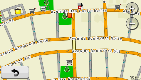
Hi Dave, I use in my nuvi 1490 another img file with only arrows and bridges. I don't know explain why, but with another img file all arrows and bridges are always on top of the way. In styles i have only the line file, and I use one code for each type of way, because I use different colors for each arrow and bridge (the same of the darker color way) highway=motorway & (oneway=yes | oneway=1 | oneway=true) [0x10401 resolution 24] highway=trunk & (oneway=yes | oneway=1 | oneway=true) [0x10402 resolution 24] highway=primary & (oneway=yes | oneway=1 | oneway=true) [0x10403 resolution 24] highway=secondary & (oneway=yes | oneway=1 | oneway=true) [0x10404 resolution 24] highway=tertiary & (oneway=yes | oneway=1 | oneway=true) [0x10405 resolution 24] highway=minor & (oneway=yes | oneway=1 | oneway=true) [0x10406 resolution 24] highway=living_street & (oneway=yes | oneway=1 | oneway=true) [0x10406 resolution 24] highway=residential & (oneway=yes | oneway=1 | oneway=true) [0x10406 resolution 24] highway=service & (oneway=yes | oneway=1 | oneway=true) [0x10407 resolution 24] highway=bridleway & (oneway=yes | oneway=1 | oneway=true) [0x10407 resolution 24] The result is something like that I'm testing different colors and kinds of arrows too. Wesley On Sat, Mar 5, 2016 at 7:01 PM, greg crago <gregcrago@gmail.com> wrote:
Dave, I have done the same thing with 1 way arrows (linetype 0x26 for me)
I have only done this for SECONDARY, TERTIARY, RESIDENTIAL, and SERVICE roads. Here is my 'line' code for SECONDARY roads:
highway=secondary & ( network=e-road | int_ref=* ) [0x04 resolution 19-19 continue] highway=secondary & oneway=yes [0x26 resolution 19 continue] highway=secondary & cycleway=lane [0x00 resolution 19 continue] highway=secondary & bridge!=yes [0x04 road_class=2 road_speed=3 resolution 19 continue] highway=secondary & bridge=yes [0x01 road_class=2 road_speed=3 resolution 22] highway=secondary_link & bridge!=yes [0x08 road_class=2 road_speed=1 resolution 19 continue] highway=secondary_link & bridge!=yes [0x23 resolution 19 continue] highway=secondary_link & oneway=yes [0x26 resolution 19 continue] highway=secondary_link & cycleway=lane [0x00 resolution 19 continue] highway=secondary_link & bridge=yes [0x01 road_class=2 road_speed=1 resolution 22]
I do this for both the road and the *_link, This is 'mid-way' in my code. You can see I also have overlay for BICYCLE lanes and BRIDGES It works and looks great.
Greg
On Sat, Mar 5, 2016 at 1:28 AM, Dave Swarthout <daveswarthout@gmail.com> wrote:
I would like to see oneway arrows drawn on top of the highway lines the way OSMAnd does it. I tried moving my oneway arrow rules to after the other highway rules were finished processing but they completely disappeared. The lines style rules are below and in my TYP file are defined as blue arrows on a transparent background.
# display direction arrows on highways highway=* & (oneway=yes | oneway=1 | oneway=true) [0x10000 resolution 24 continue with_actions] highway=* & oneway=-1 [0x10001 resolution 24 continue with_actions]
Thanks, Dave
_______________________________________________ mkgmap-dev mailing list mkgmap-dev@lists.mkgmap.org.uk http://www.mkgmap.org.uk/mailman/listinfo/mkgmap-dev
_______________________________________________ mkgmap-dev mailing list mkgmap-dev@lists.mkgmap.org.uk http://www.mkgmap.org.uk/mailman/listinfo/mkgmap-dev
@Greg - Thanks, I'm working on it but still no luck. I reproduced your code for primary highways, used the continue statement as you did, removed my old arrow rules, made sure my new "arrow way" (also used 0x26 for a code) has a transparent background but I still can't get it to work. @Wesley - Thank you as well. Your approach is interesting and I like it but it seems to me I should be able to accomplish making those arrows overlay my highways by using the proper rules in the same img file. On Sun, Mar 6, 2016 at 5:01 AM, greg crago <gregcrago@gmail.com> wrote:
Dave, I have done the same thing with 1 way arrows (linetype 0x26 for me)
I have only done this for SECONDARY, TERTIARY, RESIDENTIAL, and SERVICE roads. Here is my 'line' code for SECONDARY roads:
highway=secondary & ( network=e-road | int_ref=* ) [0x04 resolution 19-19 continue] highway=secondary & oneway=yes [0x26 resolution 19 continue] highway=secondary & cycleway=lane [0x00 resolution 19 continue] highway=secondary & bridge!=yes [0x04 road_class=2 road_speed=3 resolution 19 continue] highway=secondary & bridge=yes [0x01 road_class=2 road_speed=3 resolution 22] highway=secondary_link & bridge!=yes [0x08 road_class=2 road_speed=1 resolution 19 continue] highway=secondary_link & bridge!=yes [0x23 resolution 19 continue] highway=secondary_link & oneway=yes [0x26 resolution 19 continue] highway=secondary_link & cycleway=lane [0x00 resolution 19 continue] highway=secondary_link & bridge=yes [0x01 road_class=2 road_speed=1 resolution 22]
I do this for both the road and the *_link, This is 'mid-way' in my code. You can see I also have overlay for BICYCLE lanes and BRIDGES It works and looks great.
Greg
On Sat, Mar 5, 2016 at 1:28 AM, Dave Swarthout <daveswarthout@gmail.com> wrote:
I would like to see oneway arrows drawn on top of the highway lines the way OSMAnd does it. I tried moving my oneway arrow rules to after the other highway rules were finished processing but they completely disappeared. The lines style rules are below and in my TYP file are defined as blue arrows on a transparent background.
# display direction arrows on highways highway=* & (oneway=yes | oneway=1 | oneway=true) [0x10000 resolution 24 continue with_actions] highway=* & oneway=-1 [0x10001 resolution 24 continue with_actions]
Thanks, Dave
_______________________________________________ mkgmap-dev mailing list mkgmap-dev@lists.mkgmap.org.uk http://www.mkgmap.org.uk/mailman/listinfo/mkgmap-dev
-- Dave Swarthout Homer, Alaska Chiang Mai, Thailand Travel Blog at http://dswarthout.blogspot.com

The problem is that most Garmins don't display a bitmap on top of a vector line (esp. the major highway types like 0x01, 0x02 etc will be put on top of other lines). So you have to place the arrow on one side of the underlying highway, instead of in the center. See the typ file of the new generic map. This example will not work in some units though, it could be that your Garmin still makes a mess out of it :-( [_line] Type=0x10000 UseOrientation=N Xpm="32 15 2 1" "! c #0065FF" " c none" " " " " " " " " " " " " " " " " " " " " " " " " " ! " " !!!!!! " " ! " ;12345678901234567890123456789012 String1=0x04,oneway String2=0x03,eenrichtingsverkeer ExtendedLabels=Y FontStyle=NoLabel (invisible) CustomColor=No [end]
@Minko - But Greg says he gets the results I want with the rules he's using. So how to explain that? On Sun, Mar 6, 2016 at 3:41 PM, Minko <ligfietser@online.nl> wrote:
The problem is that most Garmins don't display a bitmap on top of a vector line (esp. the major highway types like 0x01, 0x02 etc will be put on top of other lines). So you have to place the arrow on one side of the underlying highway, instead of in the center. See the typ file of the new generic map. This example will not work in some units though, it could be that your Garmin still makes a mess out of it :-(
[_line] Type=0x10000 UseOrientation=N Xpm="32 15 2 1" "! c #0065FF" " c none" " " " " " " " " " " " " " " " " " " " " " " " " " ! " " !!!!!! " " ! " ;12345678901234567890123456789012 String1=0x04,oneway String2=0x03,eenrichtingsverkeer ExtendedLabels=Y FontStyle=NoLabel (invisible) CustomColor=No [end] _______________________________________________ mkgmap-dev mailing list mkgmap-dev@lists.mkgmap.org.uk http://www.mkgmap.org.uk/mailman/listinfo/mkgmap-dev
-- Dave Swarthout Homer, Alaska Chiang Mai, Thailand Travel Blog at http://dswarthout.blogspot.com
I dont know how Gregs typ file looks like. It depends how you have configured your type of highway, either a bitmap or vector image. Bitmap (arrow) on top of a vector image will not work in most cases, unless that bitmap is one of the major line types as in the following example: Bitmap: [_line] Type=0x02 UseOrientation=N Xpm="32 3 2 1" "! c #0030FF" " c none" " !!!!!!!! !!!!!!!! " " !!!!!!!! !!!!!!!! " " !!!!!!!! !!!!!!!! " ;12345678901234567890123456789012 String1=0x04,cycle route String2=0x03,fietsroute String3=0x02,Radroute ExtendedLabels=Y FontStyle=SmallFont CustomColor=No [end] Vector: [_line] Type=0x03 UseOrientation=N LineWidth=5 BorderWidth=1 Xpm="0 0 2 0" "1 c #B4B4B4" "2 c #525252" String1=0x04,principal highway String2=0x03,N-weg String3=0x02,Hauptverbindungsstraße ExtendedLabels=Y FontStyle=SmallFont CustomColor=No [end] ----- Oorspronkelijk bericht ----- Dave wrote: @Minko - But Greg says he gets the results I want with the rules he's using. So how to explain that?
I like Wesley's ARROWS built in to the ROAD, but my ARROWS are 16 pixels wide and sit UNDER the road and you see them protrude outside the edge of the road. (see picture) Here is my TYP file (look for 0x26) and my other post has my code for SECONDARY roads in my line file. I would like to get arrows built in to the road, mine looks bad, but does convey the 1-way direction. It seems many of us are all working on similar features and it would be nice if we all got together and made a SUPER-DEAFULT STYLE, where we could combine all of these advanced features and if mappers do not wish to use them, they can just DELETE those sections. I also wanted BRIDGES to be ON TOP, so I moved MOTORWAY linetype to 0x0b and defined BRIDGES to be 0x01 and it works. Pinns suggested this on his website, no roads cross 0x01 linetype. Greg On Sun, Mar 6, 2016 at 7:48 AM, Minko <ligfietser@online.nl> wrote:
I dont know how Gregs typ file looks like. It depends how you have configured your type of highway, either a bitmap or vector image. Bitmap (arrow) on top of a vector image will not work in most cases, unless that bitmap is one of the major line types as in the following example:
Bitmap:
[_line] Type=0x02 UseOrientation=N Xpm="32 3 2 1" "! c #0030FF" " c none" " !!!!!!!! !!!!!!!! " " !!!!!!!! !!!!!!!! " " !!!!!!!! !!!!!!!! " ;12345678901234567890123456789012 String1=0x04,cycle route String2=0x03,fietsroute String3=0x02,Radroute ExtendedLabels=Y FontStyle=SmallFont CustomColor=No [end]
Vector:
[_line] Type=0x03 UseOrientation=N LineWidth=5 BorderWidth=1 Xpm="0 0 2 0" "1 c #B4B4B4" "2 c #525252" String1=0x04,principal highway String2=0x03,N-weg String3=0x02,Hauptverbindungsstraße ExtendedLabels=Y FontStyle=SmallFont CustomColor=No [end]
------------------------------
Dave wrote:
@Minko - But Greg says he gets the results I want with the rules he's using. So how to explain that?
_______________________________________________ mkgmap-dev mailing list mkgmap-dev@lists.mkgmap.org.uk http://www.mkgmap.org.uk/mailman/listinfo/mkgmap-dev
Well, that seems to explain why my attempts aren't working. It also explains why the default style uses arrows that lie outside the highway lines. Garmin is overwriting the "arrow highway" line but the part it overwrites is the invisible part. Knowing Garmin overwrites bitmaps with those low-numbered ways means I would have to bump all highway codes up a notch and reassign them to get the effect I want. And that may produce unseen repercussions later. Or, alternatively, I could go with Wesley's or Greg's approach. I'll need to think about that for a while. As always, thanks for your help everyone. Cheers, Dave On Sun, Mar 6, 2016 at 10:34 PM, greg crago <gregcrago@gmail.com> wrote:
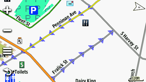
I like Wesley's ARROWS built in to the ROAD, but my ARROWS are 16 pixels wide and sit UNDER the road and you see them protrude outside the edge of the road. (see picture)
Here is my TYP file (look for 0x26)
and my other post has my code for SECONDARY roads in my line file.
I would like to get arrows built in to the road, mine looks bad, but does convey the 1-way direction.
It seems many of us are all working on similar features and it would be nice if we all got together and made a SUPER-DEAFULT STYLE, where we could combine all of these advanced features and if mappers do not wish to use them, they can just DELETE those sections.
I also wanted BRIDGES to be ON TOP, so I moved MOTORWAY linetype to 0x0b and defined BRIDGES to be 0x01 and it works. Pinns suggested this on his website, no roads cross 0x01 linetype.
Greg
On Sun, Mar 6, 2016 at 7:48 AM, Minko <ligfietser@online.nl> wrote:
I dont know how Gregs typ file looks like. It depends how you have configured your type of highway, either a bitmap or vector image. Bitmap (arrow) on top of a vector image will not work in most cases, unless that bitmap is one of the major line types as in the following example:
Bitmap:
[_line] Type=0x02 UseOrientation=N Xpm="32 3 2 1" "! c #0030FF" " c none" " !!!!!!!! !!!!!!!! " " !!!!!!!! !!!!!!!! " " !!!!!!!! !!!!!!!! " ;12345678901234567890123456789012 String1=0x04,cycle route String2=0x03,fietsroute String3=0x02,Radroute ExtendedLabels=Y FontStyle=SmallFont CustomColor=No [end]
Vector:
[_line] Type=0x03 UseOrientation=N LineWidth=5 BorderWidth=1 Xpm="0 0 2 0" "1 c #B4B4B4" "2 c #525252" String1=0x04,principal highway String2=0x03,N-weg String3=0x02,Hauptverbindungsstraße ExtendedLabels=Y FontStyle=SmallFont CustomColor=No [end]
------------------------------
Dave wrote:
@Minko - But Greg says he gets the results I want with the rules he's using. So how to explain that?
_______________________________________________ mkgmap-dev mailing list mkgmap-dev@lists.mkgmap.org.uk http://www.mkgmap.org.uk/mailman/listinfo/mkgmap-dev
_______________________________________________ mkgmap-dev mailing list mkgmap-dev@lists.mkgmap.org.uk http://www.mkgmap.org.uk/mailman/listinfo/mkgmap-dev
-- Dave Swarthout Homer, Alaska Chiang Mai, Thailand Travel Blog at http://dswarthout.blogspot.com

Hi Dave, I did not follow this thread closely but what do you mean with this ? "It also explains why the default style uses arrows that lie outside the highway lines. " Gerd ________________________________ Von: mkgmap-dev <mkgmap-dev-bounces@lists.mkgmap.org.uk> im Auftrag von Dave Swarthout <daveswarthout@gmail.com> Gesendet: Montag, 7. März 2016 00:33 An: Development list for mkgmap Betreff: Re: [mkgmap-dev] Oneway arrows Well, that seems to explain why my attempts aren't working. It also explains why the default style uses arrows that lie outside the highway lines. Garmin is overwriting the "arrow highway" line but the part it overwrites is the invisible part. Knowing Garmin overwrites bitmaps with those low-numbered ways means I would have to bump all highway codes up a notch and reassign them to get the effect I want. And that may produce unseen repercussions later. Or, alternatively, I could go with Wesley's or Greg's approach. I'll need to think about that for a while. As always, thanks for your help everyone. Cheers, Dave On Sun, Mar 6, 2016 at 10:34 PM, greg crago <gregcrago@gmail.com<mailto:gregcrago@gmail.com>> wrote: I like Wesley's ARROWS built in to the ROAD, but my ARROWS are 16 pixels wide and sit UNDER the road and you see them protrude outside the edge of the road. (see picture) Here is my TYP file (look for 0x26) and my other post has my code for SECONDARY roads in my line file. I would like to get arrows built in to the road, mine looks bad, but does convey the 1-way direction. It seems many of us are all working on similar features and it would be nice if we all got together and made a SUPER-DEAFULT STYLE, where we could combine all of these advanced features and if mappers do not wish to use them, they can just DELETE those sections. I also wanted BRIDGES to be ON TOP, so I moved MOTORWAY linetype to 0x0b and defined BRIDGES to be 0x01 and it works. Pinns suggested this on his website, no roads cross 0x01 linetype. Greg On Sun, Mar 6, 2016 at 7:48 AM, Minko <ligfietser@online.nl<mailto:ligfietser@online.nl>> wrote: I dont know how Gregs typ file looks like. It depends how you have configured your type of highway, either a bitmap or vector image. Bitmap (arrow) on top of a vector image will not work in most cases, unless that bitmap is one of the major line types as in the following example: Bitmap: [_line] Type=0x02 UseOrientation=N Xpm="32 3 2 1" "! c #0030FF" " c none" " !!!!!!!! !!!!!!!! " " !!!!!!!! !!!!!!!! " " !!!!!!!! !!!!!!!! " ;12345678901234567890123456789012 String1=0x04,cycle route String2=0x03,fietsroute String3=0x02,Radroute ExtendedLabels=Y FontStyle=SmallFont CustomColor=No [end] Vector: [_line] Type=0x03 UseOrientation=N LineWidth=5 BorderWidth=1 Xpm="0 0 2 0" "1 c #B4B4B4" "2 c #525252" String1=0x04,principal highway String2=0x03,N-weg String3=0x02,Hauptverbindungsstraße ExtendedLabels=Y FontStyle=SmallFont CustomColor=No [end] ________________________________ Dave wrote: @Minko - But Greg says he gets the results I want with the rules he's using. So how to explain that? _______________________________________________ mkgmap-dev mailing list mkgmap-dev@lists.mkgmap.org.uk<mailto:mkgmap-dev@lists.mkgmap.org.uk> http://www.mkgmap.org.uk/mailman/listinfo/mkgmap-dev _______________________________________________ mkgmap-dev mailing list mkgmap-dev@lists.mkgmap.org.uk<mailto:mkgmap-dev@lists.mkgmap.org.uk> http://www.mkgmap.org.uk/mailman/listinfo/mkgmap-dev -- Dave Swarthout Homer, Alaska Chiang Mai, Thailand Travel Blog at http://dswarthout.blogspot.com

Ligfietser is correct about non bitmap lines generally having superior draworder to bitmap lines. Again, the behaviour of lines is determined by your device ,not Mapsource or Bascemap. One sure way of getting arrows to appear in the center is by creating a) a bmp line for oneway=yes etc b) an invisible BUT routable line for the same stretch. say residential: 0x6 (make invisible and routable) and add continue if no one way (oneway!=*) then 0x10600 (residential) if one way (oneway=* & oneway!=no ) then 0x10601 (residential withy arrow in middle) -- View this message in context: http://gis.19327.n5.nabble.com/Oneway-arrows-tp5869090p5869321.html Sent from the Mkgmap Development mailing list archive at Nabble.com.

Hi, it is worth noting, that on newer nuvis oneway arrows are displayed by default. They are present on ways with no TYP graphics, and possibly on non-bitmap graphics too, but I'm not sure about later. Other peculiarity of non-bitmap graphics is that way's width is scalable on nuvis, depending on zoom. -- Best regards, Andrzej
@nwillink Now that's a clever solution. Many thanks. I'll start working on it. @Andrzej : I did not try to see if the oneways that failed to show in Basecamp were visible on my Montana. Thanks for the tip. I think we can put this thread to rest now. Again, thanks to all for your help. On Tue, Mar 8, 2016 at 7:56 AM, Andrzej Popowski <popej@poczta.onet.pl> wrote:
Hi,
it is worth noting, that on newer nuvis oneway arrows are displayed by default. They are present on ways with no TYP graphics, and possibly on non-bitmap graphics too, but I'm not sure about later.
Other peculiarity of non-bitmap graphics is that way's width is scalable on nuvis, depending on zoom.
-- Best regards, Andrzej
_______________________________________________ mkgmap-dev mailing list mkgmap-dev@lists.mkgmap.org.uk http://www.mkgmap.org.uk/mailman/listinfo/mkgmap-dev
-- Dave Swarthout Homer, Alaska Chiang Mai, Thailand Travel Blog at http://dswarthout.blogspot.com
The one way arrows that I built are visible in both BaseCamp v4.6.1 and my Garmin Montana 600 Greg On Mon, Mar 7, 2016 at 8:56 PM, Dave Swarthout <daveswarthout@gmail.com> wrote:
@nwillink
Now that's a clever solution. Many thanks. I'll start working on it.
@Andrzej : I did not try to see if the oneways that failed to show in Basecamp were visible on my Montana. Thanks for the tip.
I think we can put this thread to rest now.
Again, thanks to all for your help.
On Tue, Mar 8, 2016 at 7:56 AM, Andrzej Popowski <popej@poczta.onet.pl> wrote:
Hi,
it is worth noting, that on newer nuvis oneway arrows are displayed by default. They are present on ways with no TYP graphics, and possibly on non-bitmap graphics too, but I'm not sure about later.
Other peculiarity of non-bitmap graphics is that way's width is scalable on nuvis, depending on zoom.
-- Best regards, Andrzej
_______________________________________________ mkgmap-dev mailing list mkgmap-dev@lists.mkgmap.org.uk http://www.mkgmap.org.uk/mailman/listinfo/mkgmap-dev
-- Dave Swarthout Homer, Alaska Chiang Mai, Thailand Travel Blog at http://dswarthout.blogspot.com
_______________________________________________ mkgmap-dev mailing list mkgmap-dev@lists.mkgmap.org.uk http://www.mkgmap.org.uk/mailman/listinfo/mkgmap-dev

participants (9)
-
 Andrzej Popowski
 -
 Arndt Röhrig
 -
 Dave Swarthout
 -
 Gerd Petermann
 -
 greg crago
 -
 Minko
Minko -
 nwillink
 -
 Walter Schlögl
 -
 Wesley Martins