Slightly OT: TYP files, lines with borders

Hi all, Many people have created TYP files that define lines to have borders, to make them look more like paper maps (e.g. the UK's OS series). This looks fine in Mapsource, but in the GPS unit things go horribly wrong (see screencap). In effect, the GPS draws the border *perpendicular* to the way in question every time it encounters the end of a wayed segment. Given that in OSM ways are usually composed of multiple segments joined together, this means that ways on the GPS are a horrible collection of little "worms" all joined together. The resulting effect is unusable. But as I say, this doesn't happen at all in MapSource (second screenshot). Is this a known problem with TYPs, line definitions with borders and (certain?) Garmin GPS units or am I doing something silly? -- Charlie

I think this is due to the fact that borders are not seen as lines of a larger width plotted below the matching highway lines, unlike Mapsource Nick -------------------------------------------------- From: "Charlie Ferrero" <charlie@cferrero.net> Sent: Saturday, February 13, 2010 9:23 AM To: "Development list for mkgmap" <mkgmap-dev@lists.mkgmap.org.uk> Subject: [mkgmap-dev] Slightly OT: TYP files, lines with borders
Hi all,
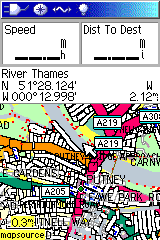
Many people have created TYP files that define lines to have borders, to make them look more like paper maps (e.g. the UK's OS series). This looks fine in Mapsource, but in the GPS unit things go horribly wrong (see screencap). In effect, the GPS draws the border *perpendicular* to the way in question every time it encounters the end of a wayed segment. Given that in OSM ways are usually composed of multiple segments joined together, this means that ways on the GPS are a horrible collection of little "worms" all joined together. The resulting effect is unusable.
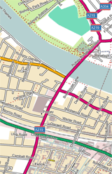
But as I say, this doesn't happen at all in MapSource (second screenshot).
Is this a known problem with TYPs, line definitions with borders and (certain?) Garmin GPS units or am I doing something silly? -- Charlie

Charlie Ferrero wrotes *on* /Sat Feb 13 09:23:30 GMT 2010/ --Is this a known problem with TYPs, line definitions with borders and --(certain?) Garmin GPS units or am I doing something silly? It's the first time that i see this effect. There are two ways of giving a definition for the drawing of a polyline in typ file. 1. providing a bitmap definition 2. providing the definition in linewidth/borderwidth format For further informations you can have a look in the manuals of the mapcompiler cgpsmapper and MapTK. I don't think that the effect is only caused by the way of definition. But maybe it's caused by erroneous definitiopn in the typ file and/or the map or it's related to the gps unit. First i would have a look into the typ-file. Afaik not all Garmin Gps have the ability to use typ-files(especially older series doesn't), so may be this also could be a reason cheers Gert

Charlie Ferrero escribió:
Hi all,
Many people have created TYP files that define lines to have borders, to make them look more like paper maps (e.g. the UK's OS series). This looks fine in Mapsource, but in the GPS unit things go horribly wrong (see screencap). In effect, the GPS draws the border *perpendicular* to the way in question every time it encounters the end of a wayed segment. Given that in OSM ways are usually composed of multiple segments joined together, this means that ways on the GPS are a horrible collection of little "worms" all joined together. The resulting effect is unusable.
But as I say, this doesn't happen at all in MapSource (second screenshot).
Is this a known problem with TYPs, line definitions with borders and (certain?) Garmin GPS units or am I doing something silly? I have motorways (0x01) defined with borders (2 common colors (line/border or fg/bg), line style: width 2px + border 1 px in the online editor) and I don't see those worms neither in nuvi nor in legend HCx.

On 02/13/2010 10:23 AM, Charlie Ferrero wrote:
Is this a known problem with TYPs, line definitions with borders and (certain?) Garmin GPS units or am I doing something silly?
It looks like that on my topo map, too: http://www.kleineisel.de/blogs/media/blogs/osmmap/6.png If you zoom in a bit it isn't so bad after all.
Ralf Kleineisel wrote:
On 02/13/2010 10:23 AM, Charlie Ferrero wrote:
Is this a known problem with TYPs, line definitions with borders and (certain?) Garmin GPS units or am I doing something silly?
It looks like that on my topo map, too:
http://www.kleineisel.de/blogs/media/blogs/osmmap/6.png
If you zoom in a bit it isn't so bad after all. I'm relieved to hear it's not just me. Maybe it depends on the GPS unit?
Charlie

participants (6)
-
 Carlos Dávila
 -
 Charlie Ferrero
 -
 Gert Münzel
 -
 n willink
 -
 Ralf Kleineisel
 -
 WanMil