House numbers supported?

Hello, I tried to put some house numbers in OSM in order to be searchable on my Garmin device. See http://www.openstreetmap.org/?lat=-22.275439&lon=166.45965&zoom=18&layers=B0... and http://www.openstreetmap.org/?lat=-22.15022&lon=166.48473&zoom=17&layers=B00... for the two test locations. I was unable to find this house numbers on my Nüvi755. (using the 20091216_gmapsupp.zip available at my site http://www.oesterlin.ile.nc/gps/ ) Is this feature supported by mkgmap? Or do I make some mistake somewhere? Thank you for your advice! Kind regards Hendrik Oesterlin New Caledonia ___________________________________________________________ Der frühe Vogel fängt den Wurm. Hier gelangen Sie zum neuen Yahoo! Mail: http://mail.yahoo.de

On Fri, Dec 18, 2009 at 07:11:41PM +1100, Hendrik Oesterlin wrote:
I tried to put some house numbers in OSM in order to be searchable on my Garmin device.
See http://www.openstreetmap.org/?lat=-22.275439&lon=166.45965&zoom=18&layers=B0... and http://www.openstreetmap.org/?lat=-22.15022&lon=166.48473&zoom=17&layers=B00... for the two test locations.
I was unable to find this house numbers on my Nüvi755. (using the 20091216_gmapsupp.zip available at my site http://www.oesterlin.ile.nc/gps/ )
Is this feature supported by mkgmap?
As far as I can tell, it is not yet supported. A friend once showed a commercial map on his Edge 705, and it displayed house numbers when you moved the pointer aside the street, and I suppose that house numbers would have worked in the address search too. In mkgmap-generated maps, addr:* and phone do show up in POI details on the Edge 705. That reminds me: Is it possible to change the address format? Many European countries (except the UK) would display addresses like this: name addr:street addr:housenumber addr:postcode addr:city addr:country In mkgmap-generated maps, the street/housenumber and postcode/city are the other way around. Looking at the gmapsupp.img, it seems that the addresses are formatted in that way by Garmin. Also, if addr:housenumber contains a dash, it will be converted to "Apt.", apparently by Garmin. That might make sense in some countries, but in this part of the world, large properties can sometimes span several house numbers, and 12-14 would mean a range of house numbers, not "12 Apt. 14". Best regards, Marko
Bonjour Marko, Le vendredi 18 décembre 2009 à 19:58:50, vous écriviez :
On Fri, Dec 18, 2009 at 07:11:41PM +1100, Hendrik Oesterlin wrote:
I tried to put some house numbers in OSM in order to be searchable on my Garmin device.
See http://www.openstreetmap.org/?lat=-22.275439&lon=166.45965&zoom=18&layers=B0... and http://www.openstreetmap.org/?lat=-22.15022&lon=166.48473&zoom=17&layers=B00... for the two test locations.
I was unable to find this house numbers on my Nüvi755. (using the 20091216_gmapsupp.zip available at my site http://www.oesterlin.ile.nc/gps/ )
Is this feature supported by mkgmap?
As far as I can tell, it is not yet supported.
It should be possible to convert the OSM nodes containing the addr:housenumber addr:street addr:postcode addr:city addr:country tags to an POI using as name something like "housenumber street postcode city country" and building=yes (or something similar)? Has someone already written an appropriate line to put in the "points" file of the styles folder? Or has someone written an regular expression code regrouping the different addr:* tags in an name=* tag before the OSM data is converted by mkgmap ? -- Cordialement, Hendrik Courriel : hendrikmail2002@yahoo.de
On Sun, Dec 20, 2009 at 03:34:30PM +1100, Hendrik Oesterlin wrote:
I tried to put some house numbers in OSM in order to be searchable on my Garmin device.
See http://www.openstreetmap.org/?lat=-22.275439&lon=166.45965&zoom=18&layers=B0... and http://www.openstreetmap.org/?lat=-22.15022&lon=166.48473&zoom=17&layers=B00... for the two test locations.
I was unable to find this house numbers on my Nüvi755. (using the 20091216_gmapsupp.zip available at my site http://www.oesterlin.ile.nc/gps/ )
Is this feature supported by mkgmap?
As far as I can tell, it is not yet supported.
It should be possible to convert the OSM nodes containing the
addr:housenumber addr:street addr:postcode addr:city addr:country
tags to an POI using as name something like "housenumber street postcode city country" and building=yes (or something similar)?
Has someone already written an appropriate line to put in the "points" file of the styles folder?
I believe that the original question was about house numbers that would appear on the map like they do in paid-for Garmin maps: without a POI, displayed in a tooltip when you hover the pointer next to the street line. I saw this about 4 months ago on a friend's Edge 705. There were no POIs or polygons in the area; just a residential street on a yellow background.
Or has someone written an regular expression code regrouping the different addr:* tags in an name=* tag before the OSM data is converted by mkgmap ?
Something like this should work to that effect: building=* { name '${addr:housenumber|def:} ${addr:street|def:} ${addr:postcode|def:} ${addr:city|def:} ${addr:country|def:}' } But I do not see the point of this. If you select a POI on the map, the POI details screen will already display these addr:* tags and the phone number, at least on the Edge 705. I do not really know anything about this. My not-so-well-educated guess is that the house numbers could show up if you ran mkgmap --index and uploaded the map to the device from MapSource. I have never tried either. Best regards, Marko

On Dec 20, 2009, at 9:08, Marko Mäkelä wrote:
I do not really know anything about this. My not-so-well-educated guess is that the house numbers could show up if you ran mkgmap --index and uploaded the map to the device from MapSource. I have never tried either.
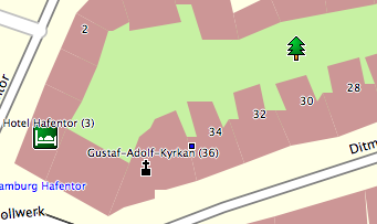
I am fairly certain that the --index option does not (yet) include house numbers. As far as I know there are two significant problems preventing this: 1) the Garmin house number format still needs to be reverse engineered, and 2) some kind of mapping would have to be devised to translate the various OSM address schemes to the Garmin format. Both are non-trivial, I would think. Individual POIs can have address data, but this is separate from the --index option and the address search. The POI address data are simply displayed when you choose the detail of that POI; the address appears to have no other function. (Except, as I understand, that certain GPS units can trigger the dialing of telephone numbers included in the address.) - Also be aware that not all POI types can hold address data. Shopping and other institutions can generally have address data, but other natural and man-made items cannot. As a workaround for the missing house numbers in the index, you can get some house numbers to be displayed on the map, if you add the numbers to the names of items in the points and polygons style files. I have the following at the bottom of my polygons file: addr:housenumber=* & name=* {name '${name} (${addr:housenumber})'} addr:housenumber=* & addr:housename=* {name '${addr:housename} ${addr:housenumber}'} addr:housename=* & name!=* {name '${addr:housename}'} addr:housenumber=* {name '${addr:housenumber}'} This will append the house number (or name) in parenthesis to the name of the polygon, if it has one. If the polygon has no name, the house number is used as the name. The effect is much like the house numbers which appear in the Slippy Map. I have attached a screen shot of a section of Hamburg which shows how this looks. Note that the two POIs (Hotel Hafentor and Gustaf-Adolf-Kyrkan) have house numbers because they were generated from polygons with the --add-pois-to-areas option; I have no address lines in the points file. Going back to the index topic, if you want to see a good example of a map that has house number information, take a look at the New Zealand Open GPS map: http://nzopengps.org/ Their map does not use OSM data and uses cGPSmapper, so it is of little relevance to this project, but it does give a good idea of how a map with proper street number indexing should function. Cheers.

Going back to the index topic, if you want to see a good example of a map that has house number information, take a look at the New Zealand Open GPS map:
Their map does not use OSM data and uses cGPSmapper, so it is of little relevance to this project, but it does give a good idea of how a map with proper street number indexing should function.
I believe that house numbers along a road are saved in the NET section. It is possible that they would be in the index file as well although I would have thought that would be unnecessary. I know where they are stored from John Mechalas's document but not the actual format of the numbers. ..Steve
"Clinton Gladstone" clinton.gladstone@googlemail.com wrote on 21/12/2009 at 09:38:57 +1100 subject "[mkgmap-dev] House numbers supported?" :
As a workaround for the missing house numbers in the index, you can get some house numbers to be displayed on the map, if you add the numbers to the names of items in the points and polygons style files.
I have the following at the bottom of my polygons file:
addr:housenumber=* & name=* {name '${name} (${addr:housenumber})'} addr:housenumber=* & addr:housename=* {name '${addr:housename} ${addr:housenumber}'} addr:housename=* & name!=* {name '${addr:housename}'} addr:housenumber=* {name '${addr:housenumber}'}
This will append the house number (or name) in parenthesis to the name of the polygon, if it has one. If the polygon has no name, the house number is used as the name. The effect is much like the house numbers which appear in the Slippy Map.
Thank you very much for this good workaround! It performs very good for polygons, but for individual points I was not able to make it work. Do you have the appropriate code to put in the points file in order to show in the same way as for the polygons the house number in the name?
I have attached a screen shot of a section of Hamburg which shows how this looks. Note that the two POIs (Hotel Hafentor and Gustaf-Adolf-Kyrkan) have house numbers because they were generated from polygons with the --add-pois-to-areas option; I have no address lines in the points file.
This looks good and should be quite convenient to use.
Going back to the index topic, if you want to see a good example of a map that has house number information, take a look at the New Zealand Open GPS map:
Their map does not use OSM data and uses cGPSmapper, so it is of little relevance to this project, but it does give a good idea of how a map with proper street number indexing should function.
I already saw this mapping project. It seems to be very complete. Unfortunately, the data of the nzopengps.org maps is not symphonized with the OSM base. Merry Christmas to all of you! -- Sincerely Hendrik Oesterlin - email hendrikmail2002@yahoo.de ___________________________________________________________ Der frühe Vogel fängt den Wurm. Hier gelangen Sie zum neuen Yahoo! Mail: http://mail.yahoo.de
participants (4)
-
 Clinton Gladstone
 -
 Hendrik Oesterlin
 -
 Marko Mäkelä
 -
 Steve Ratcliffe