Commit: r1198: Merge in the sea polygon patch from the multipolygon branch.

Version 1198 was commited by steve on 2009-09-17 10:27:24 +0100 (Thu, 17 Sep 2009) Merge in the sea polygon patch from the multipolygon branch. You need to give the --generate-sea option at the moment to switch it on. Written by Christian Gawron

Hello list, svn commit schreef:
Version 1198 was commited by steve on 2009-09-17 10:27:24 +0100 (Thu, 17 Sep 2009)
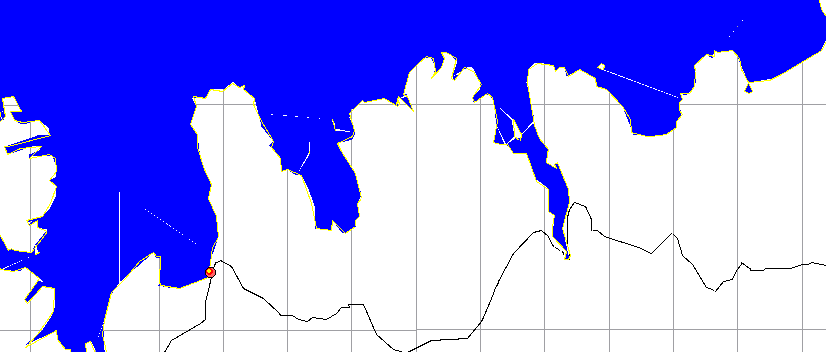
Hmm. While it is generally known that much of the Netherlands is sub sea level, the map that's currently resulting from mkgmap --generate-sea feels like a Greenpeace-ad ("rising sea levels! Save the environment!") My 63240007 tile is completely flooded. Some other tiles are too, but 63240007 is in the middle of the map, which makes a Geofabrik cutoff fault less likely. Here's the setup: areas.list: 63240001: 2383872,153600 to 2424832,202752 63240002: 2392064,202752 to 2424832,235520 63240003: 2363392,235520 to 2396160,292864 63240004: 2396160,235520 to 2424832,260096 63240005: 2396160,260096 to 2424832,321536 63240006: 2424832,178176 to 2437120,223232 63240007: 2424832,223232 to 2437120,256000 63240008: 2437120,206848 to 2445312,256000 63240009: 2445312,198656 to 2494464,256000 63240010: 2424832,256000 to 2453504,329728 63240011: 2453504,256000 to 2494464,288768 63240012: 2453504,288768 to 2502656,337920 (Generated from java -enableassertions -Xmx$memory -jar ../splitter/dist/splitter.jar --max-nodes=600000 --description=$land unpacked.osm) java -enableassertions -Xmx$memory -jar ../mkgmap/dist/mkgmap.jar --make-opposite-cycleways --mapname=3100${mapid} --latin1 --remove-short-arcs=5.5 --lower-case --route --preserve-element-order --max-jobs --link-pois-to-ways --location-autofill-1 --generate-sea --description=$land --family-name="Openstreetmap `date +'%d %b %y'`" --series-name="OSM-Valentijn" --gmapsupp --tdbfile --net -c template.args Any ideas? Best regards, Valentijn

Two things I noticed when I used this in the multipolygon branch. 1. One tile was completely flooded because of a lake multi-polygon crosses the splitted files. http://osm.org/go/4zhDKVO- 2. A big island was flooded when very small island surrounds it. http://osm.org/go/4yJ8BfT- Will test again when I have my mkgmap dev machine tonight. On 9/17/09, Valentijn Sessink <valentyn@blub.net> wrote:
Hello list,
svn commit schreef:
Version 1198 was commited by steve on 2009-09-17 10:27:24 +0100 (Thu, 17 Sep 2009)
Hmm. While it is generally known that much of the Netherlands is sub sea level, the map that's currently resulting from mkgmap --generate-sea feels like a Greenpeace-ad ("rising sea levels! Save the environment!")
My 63240007 tile is completely flooded. Some other tiles are too, but 63240007 is in the middle of the map, which makes a Geofabrik cutoff fault less likely. Here's the setup:
areas.list: 63240001: 2383872,153600 to 2424832,202752 63240002: 2392064,202752 to 2424832,235520 63240003: 2363392,235520 to 2396160,292864 63240004: 2396160,235520 to 2424832,260096 63240005: 2396160,260096 to 2424832,321536 63240006: 2424832,178176 to 2437120,223232 63240007: 2424832,223232 to 2437120,256000 63240008: 2437120,206848 to 2445312,256000 63240009: 2445312,198656 to 2494464,256000 63240010: 2424832,256000 to 2453504,329728 63240011: 2453504,256000 to 2494464,288768 63240012: 2453504,288768 to 2502656,337920
(Generated from java -enableassertions -Xmx$memory -jar ../splitter/dist/splitter.jar --max-nodes=600000 --description=$land unpacked.osm)
java -enableassertions -Xmx$memory -jar ../mkgmap/dist/mkgmap.jar --make-opposite-cycleways --mapname=3100${mapid} --latin1 --remove-short-arcs=5.5 --lower-case --route --preserve-element-order --max-jobs --link-pois-to-ways --location-autofill-1 --generate-sea --description=$land --family-name="Openstreetmap `date +'%d %b %y'`" --series-name="OSM-Valentijn" --gmapsupp --tdbfile --net -c template.args
Any ideas?
Best regards,
Valentijn _______________________________________________ mkgmap-dev mailing list mkgmap-dev@lists.mkgmap.org.uk http://www.mkgmap.org.uk/mailman/listinfo/mkgmap-dev
-- cheers, maning ------------------------------------------------------ "Freedom is still the most radical idea of all" -N.Branden wiki: http://esambale.wikispaces.com/ blog: http://epsg4253.wordpress.com/ ------------------------------------------------------

I tried processing great_britain.osm with the --generate-sea option and found the following issues: 1 - it generated lots of warnings like this: 2009/09/17 10:40:26 WARNING (Osm5XmlHandler): Way null (OSM id 4611686018427388109) has short arc (0.00m) - but it can't be removed because both ends of the arc are boundary nodes! Not a real problem because the line isn't actually a road but it looks rather scary. 2 - the last line in my log file says: 2009/09/17 10:51:34 WARNING (Osm5XmlHandler): Non-closed coastline segment does not hit bounding box: 309959855 (59.12089/-5.81827) 309959797 (59.12314/-5.81254) http://www.openstreetmap.org/?lat=59.12089&lon=-5.81827&zoom=17 The mkgmap never finishes, at that point it just hangs gobbling 100% CPU so I guess it's stuck in some loop. Perhaps the message is related? In the code, I see it uses (1L << 62) + nextFakeId++ everywhere. Also, the comment on line 65 is now not true. Mark

Hi Mark On 17/09/09 11:22, Mark Burton wrote:
2009/09/17 10:51:34 WARNING (Osm5XmlHandler): Non-closed coastline segment does not hit bounding box: 309959855 (59.12089/-5.81827) 309959797 (59.12314/-5.81254) http://www.openstreetmap.org/?lat=59.12089&lon=-5.81827&zoom=17
The mkgmap never finishes, at that point it just hangs gobbling 100% CPU so I guess it's stuck in some loop. Perhaps the message is related?
On my uk extract, the final tile took an excessively long time to complete, but it did eventually do so, although as reported before it was inside-out, ie all the land was sea. ..Steve

On Thu, Sep 17, 2009 at 10:27:24AM +0100, svn commit wrote:
Version 1198 was commited by steve on 2009-09-17 10:27:24 +0100 (Thu, 17 Sep 2009)
Merge in the sea polygon patch from the multipolygon branch.
You need to give the --generate-sea option at the moment to switch it on.
I tried it on Finland, but it gets stuck (over 10 minutes of CPU time and counting). Assertions are enabled, nothing gets printed. If I remove generate-sea: from mkgmap.args, I get output (zero length arc warnings) in about 2.5 minutes, and the command finishes in less than 3 minutes, even with assertions enabled. My scripts are at http://www.polkupyoraily.net/osm/, and I am using the Geofabrik finland.osm.bz2 extract. I am using Debian GNU/Linux 5.0.2 and the sun-java6-jdk package version 6-12-1. java -version says: java version "1.6.0_12" Java(TM) SE Runtime Environment (build 1.6.0_12-b04) Java HotSpot(TM) Client VM (build 11.2-b01, mixed mode, sharing) Is --generate-sea supposed to be very slow, or could it be stuck in an infinite loop? Best regards, Marko

On Thu, Sep 17, 2009 at 9:27 AM, svn commit <svn@mkgmap.org.uk> wrote:
Version 1198 was commited by steve on 2009-09-17 10:27:24 +0100 (Thu, 17 Sep 2009)
Merge in the sea polygon patch from the multipolygon branch.
You need to give the --generate-sea option at the moment to switch it on.
(B.t.w. that option isn't documented in --help=options) It works fine for the map I generate at http://osm.nix.is Although the coastlines I have to deal with are comparatively simple. I'm generating the map for a bunch of islands surrounded by sea on all sides. The size of the map went from 2.5 MB to 3.0 MB. I don't get any warnings from mkgmap (other than zero-arch routing warnings from --route). The only issue I see is that sometimes lines appear in the sea where it looks like two sea titles have been not quite stitched together (see attachment). This appears both in qlandkarte and on the garmin device but goes away when I zoom in, and then sometimes reappears again. There's nothing in the data for that explains the problem (like ferry lines): http://osm.org/go/e1lYQC- Thanks to everyone who worked on this feature. It makes the maps a *lot* more useful in places where the ocean is a major feature (which is where most of species happens to live).
reporting my results for the Philippines: Using a single unsplitted Philippines time java -Xmx1512m -jar /home/maning/osm/routable_garmin/mkgmap/trunk/dist/mkgmap.jar --code-page=1252 --ea --tdbfile --latin1 --country-abbr=PHI --country-name=PHILIPPINES --remove-short-arcs=5 --route --road-name-pois --add-pois-to-areas --family-id=639 --family-name="OSM_PHIL" --overview-mapname=40000001 --series-name="OSM_PHIL" --description="OSM_PHIL" --generate-sea --style-file="/home/maning/osm/routable_garmin/svn/styles/experimental_master_style" /home/maning/osm/20090912/philippines.osm real 88m49.267s user 88m22.067s sys 0m12.873s compile time is 88 m Most large islands are above water! Clap, clap, clap! http://www.flickr.com/photos/esambale/3931037708/ There are small island groups that are submerged. I've checked the dat and it seems OK. http://farm4.static.flickr.com/3457/3930253533_f80fb2c0c0_m.jpg Using a splitted Philippine. time java -Xmx1512m -jar /home/maning/osm/routable_garmin/mkgmap/trunk/dist/mkgmap.jar --code-page=1252 --ea --tdbfile --latin1 --country-abbr=PHI --country-name=PHILIPPINES --remove-short-arcs=5 --route --road-name-pois --add-pois-to-areas --family-id=639 --family-name="OSM_PHIL" --overview-mapname=40000001 --series-name="OSM_PHIL" --description="OSM_PHIL" --generate-sea --style-file="/home/maning/osm/routable_garmin/svn/styles/experimental_master_style" /home/maning/osm/20090912/split_file/*.osm.gz real 21m59.543s user 21m59.006s sys 0m2.524s compile time is shorter (21 m) A tile with incomplete lake is submerged. The remaining portion of the lake in the adjacent tile is OK. http://farm3.static.flickr.com/2421/3930260941_d8e30eb4cf_m.jpg Bigger islands are submerged as well as some smaller island groups http://farm3.static.flickr.com/2477/3930257831_e4323d6a27_m.jpg http://www.flickr.com/photos/esambale/3931043920/ note: the last image shows what seems to be an incomplete coastline but zooming in shows it is not. Overall, I think the --generate-sea works OK if the osm tile contains closed coastline. There are problems when there is a mixture of incomplete coastline and large lakes. On Fri, Sep 18, 2009 at 12:16 AM, Ævar Arnfjörð Bjarmason <avarab@gmail.com> wrote:
On Thu, Sep 17, 2009 at 9:27 AM, svn commit <svn@mkgmap.org.uk> wrote:
Version 1198 was commited by steve on 2009-09-17 10:27:24 +0100 (Thu, 17 Sep 2009)
Merge in the sea polygon patch from the multipolygon branch.
You need to give the --generate-sea option at the moment to switch it on.
(B.t.w. that option isn't documented in --help=options)
It works fine for the map I generate at http://osm.nix.is Although the coastlines I have to deal with are comparatively simple. I'm generating the map for a bunch of islands surrounded by sea on all sides.
The size of the map went from 2.5 MB to 3.0 MB. I don't get any warnings from mkgmap (other than zero-arch routing warnings from --route).
The only issue I see is that sometimes lines appear in the sea where it looks like two sea titles have been not quite stitched together (see attachment). This appears both in qlandkarte and on the garmin device but goes away when I zoom in, and then sometimes reappears again.
There's nothing in the data for that explains the problem (like ferry lines): http://osm.org/go/e1lYQC-
Thanks to everyone who worked on this feature. It makes the maps a *lot* more useful in places where the ocean is a major feature (which is where most of species happens to live).
_______________________________________________ mkgmap-dev mailing list mkgmap-dev@lists.mkgmap.org.uk http://www.mkgmap.org.uk/mailman/listinfo/mkgmap-dev
-- cheers, maning ------------------------------------------------------ "Freedom is still the most radical idea of all" -N.Branden wiki: http://esambale.wikispaces.com/ blog: http://epsg4253.wordpress.com/ ------------------------------------------------------

svn commit escribió:
Version 1198 was commited by steve on 2009-09-17 10:27:24 +0100 (Thu, 17 Sep 2009)
Merge in the sea polygon patch from the multipolygon branch.
You need to give the --generate-sea option at the moment to switch it on.
Written by Christian Gawron I've been using v1144+sea_polygons_patch_v5 with no problem (apart from some flooded areas) but if I use current trunk with the same parameters no sea is generated. I have tried with different osm files with the same result. My command line is: java -Xmx1000m -enableassertions -jar mkgmap.jar --generate-sea --route --latin1 --code-page=1252 --description="OpenStreetMap-Iberia" --gmapsupp --country-name=ESPAÑA --country-abbr=ESP --family-name="Open Street Map" --family-id=18 --product-id=318 --series-name="OSM-Iberia-s" --road-name-pois --ignore-maxspeeds --remove-short-arcs --preserve-element-order --add-pois-to-areas --location-autofill=1 --style=mio 6*.osm.gz Changing mkgmap.jar by mkgmap1144-sea.jar it works fine. Any hint? Regards Carlos
participants (8)
-
 Carlos Dávila
 -
 maning sambale
 -
 Mark Burton
 -
 Marko Mäkelä
 -
 Steve Ratcliffe
 -
 svn commit
 -
 Valentijn Sessink
 -
 Ævar Arnfjörð Bjarmason