
Hi all, some month ago we discussed the idea to implement addr:place support. It it assumed that an address has addr:housenumber and either addr:place or addr:street. Up to now those with addr:place are ignored. It is also assumed that the addr:place tag is used in hamlets and small villages and that the roads in such a hamlet have no name. I've coded the following simple approach: For each element (node/way) with addr:housenumber=* and addr:place=* and addr:street!=* search the nearest routable way that has no name (mkgmap:street!=*) If the closest road is within a given range (150m), store the place name as a possible road name. Perform a 2nd search to find also the closest road with a name or ref. If we find exactly one possible name for the road, use it. Problem 1) What should happen if the algo finds multiple possible names for one road? This happens quite often. Typical reasons: a) The road is rather long and connects two or more hamlets. I think it would be best to split the road so that we can give it different names. Maybe split into three parts so that the part between the hamlets stays unnamed. b) The road is near the boundary (or on the boundary). Houses on the left belong to hamlet A, the others to B. This is a bit more complicated. I see these possible solutions: b1) ignore the road and the houses which are close to it (address search will not find them) b2) duplicate the road and give the original road the name A and the copy the name B Problem 2) What should happen when the closest road is one with a name and the closest unnamed road is too far away? I think in many cases we have to treat this as an error in the OSM data . Problem 2b) What should happen when the closest road is one with a name and the closest unnamed road is a bit more away, e.g. 20m and 50m ? I fear this will require complex analysis, so it will be ignored for now. Problem 3) What should happen when the closest road is one with a ref, but no name? I think this is like problem 1). We can split the road, give the part through the hamlet the name of the hamlet (in addition to the ref) Do you see other possible problems or solutions? Is one of the suggested solutions a no-go? Any input is welcome. Gerd

Hi Gerd, not much help from me, but some observations. If you add a name to a road, then it will be visible on GPS. I find it quite interesting, to know place name on nuvi, displayed as a road. But it would be wrong, if road would have names outside village area. So your algorithm should limit names to area near buildings. If road has no name but ref number, it is usually displayed as a shield with number. I would prefer to preserve this shield. You could for example add place name as secondary label after finalize stage. Actually you could do it for a road with proper name too. Building with addr:place are usually scattered at random. If you add numbers to multiple road segments, you can create layout, where GPS interpolating numbers will finds the same number in multiple segments. In my opinion, addr:place is a good candidate for point addressing. I have written about it: create short line at the point coordinates and attach house number and place name to it. -- Best regards, Andrzej
Hi Andrzej,
not much help from me, but some observations.
If you add a name to a road, then it will be visible on GPS. I find it quite interesting, to know place name on nuvi, displayed as a road. But it would be wrong, if road would have names outside village area. So your algorithm should limit names to area near buildings. Good point. I'll try to implement that, but I see some possible problems with the current data flow.
If road has no name but ref number, it is usually displayed as a shield with number. I would prefer to preserve this shield. You could for example add place name as secondary label after finalize stage. Actually you could do it for a road with proper name too.
Yes, tried that (the latte) already. Have not found a solution that shows the right name in address search and name+shield on the map. I think you found the same result. I'll try again with roads that only have a ref if I find a way to split roads.
Building with addr:place are usually scattered at random. If you add numbers to multiple road segments, you can create layout, where GPS interpolating numbers will finds the same number in multiple segments. In the branch mkgmap has a detection for this "random" case and it creates no interpolation numbers when the random case is detected.
In my opinion, addr:place is a good candidate for point addressing. I have written about it: create short line at the point coordinates and attach house number and place name to it.
I thought about this and I think it doesn't work in maps which support routing. If fear when I add "invisible" and roads and don't add them to the routing network routing to such an address will not work. Maybe I'll try that out when the rest is done. Gerd
Hi Gerd,
If fear when I add "invisible" and roads and don't add them to the routing network routing to such an address will not work.
It works for me. I create routable map with cgpsmapper, where I add objects like this for each city: [POLYLINE] Type=0x13 Label=DOBRZEWINO CityName=DOBRZEWINO RegionName=POMORSKIE CountryName=POLSKA TOPO~[0X1D]PL Data0=(54.45135,18.37234),(54.45144,18.37242) [END] This is not a routable road but can be found in address search. I also create address map for Poland. Map is compiled with mkgmap but I strip NOD subfile from it. This way it becomes non-routable but contains address search: http://www.gmaptool.eu/en/content/poland-addresses-osm -- Best regards, Andrzej
Hi Andrzej,
I also create address map for Poland. Map is compiled with mkgmap but I strip NOD subfile from it. This way it becomes non-routable but contains address search:
please try r3519. It should allow again to use --net instead of --route, so you don't have to strip the NOD subfile. Gerd
Hi Andrzej, seems I did not see the wood because of the trees :-O I tried a quick hack to generate a zero-length road for each addr:place node and it seems to work. Only problem: These roads are also added to the NOD file. The current code always adds all MapRoad instances to the NOD, I have to find out how to add MapRoads to NET without adding them to NOD without messing up the pointers. This would also be useful when --net is used without --route. Gerd popej wrote
Hi Gerd,
If fear when I add "invisible" and roads and don't add them to the routing network routing to such an address will not work.
It works for me. I create routable map with cgpsmapper, where I add objects like this for each city:
[POLYLINE] Type=0x13 Label=DOBRZEWINO CityName=DOBRZEWINO RegionName=POMORSKIE CountryName=POLSKA TOPO~[0X1D]PL Data0=(54.45135,18.37234),(54.45144,18.37242) [END]
This is not a routable road but can be found in address search.
I also create address map for Poland. Map is compiled with mkgmap but I strip NOD subfile from it. This way it becomes non-routable but contains address search: http://www.gmaptool.eu/en/content/poland-addresses-osm
-- Best regards, Andrzej _______________________________________________ mkgmap-dev mailing list
mkgmap-dev@.org
-- View this message in context: http://gis.19327.n5.nabble.com/addr-place-support-tp5839721p5839846.html Sent from the Mkgmap Development mailing list archive at Nabble.com.
Hi Andrzej, the problem is that the current code separates roads from routable ways at the wrong place. All MapRoad instances are added to the road network. I have to find out what parts of the data flow I have to skip so that the pseudo roads are not added to NOD. It is easy to add a flag like skipAddToNOD, but it is not so easy to find out where to use the flag ;-) I am sure I can find a solution. Gerd popej wrote
Hi Gerd,
I have to find out how to add MapRoads to NET without adding them to NOD without messing up the pointers.
Maybe you could check if road have defined road_class? My guess is that road_class is needed in NOD but not in NET.
-- Best regards, Andrzej _______________________________________________ mkgmap-dev mailing list
mkgmap-dev@.org
-- View this message in context: http://gis.19327.n5.nabble.com/addr-place-support-tp5839721p5839851.html Sent from the Mkgmap Development mailing list archive at Nabble.com.
Hi Andrzej, well, I think I managed to write a map that supports routing without adding the zero-length "pseudo roads" to the NOD part, but routing doesn't work when I use the addresses as waypoints for the route :-( If I use address search to find the address and select a road nearby, routing seems to works fine. I did not try with the device, but I expect the same problem. Conclusion: I think I still have to find the closest (normal) road to the addr:place house and add the address information to that road, or maybe to a copy of that road so that I can add the place name as road name. Gerd
Date: Sun, 5 Apr 2015 19:30:03 +0200 From: popej@poczta.onet.pl To: mkgmap-dev@lists.mkgmap.org.uk Subject: Re: [mkgmap-dev] addr:place support
Hi Gerd,
I have to find out how to add MapRoads to NET without adding them to NOD without messing up the pointers.
Maybe you could check if road have defined road_class? My guess is that road_class is needed in NOD but not in NET.
-- Best regards, Andrzej _______________________________________________ mkgmap-dev mailing list mkgmap-dev@lists.mkgmap.org.uk http://www.mkgmap.org.uk/mailman/listinfo/mkgmap-dev
Hi Gerd,
routing doesn't work when I use the addresses as waypoints for the route :-(
I'm not sure what are you doing. I think Garmin can calculate a route through any points, regardless if they are on road or not. When using address point outside road, it calculate route to the nearest point on road and then straight line towards address. Maybe this doesn't work, if point is too far from any road? I haven't tested it on single map, I have used non-routable transparent overlay with addresses and a routable map. In this configuration, nuvi calculate route as in attached picture. -- Best regards, Andrzej
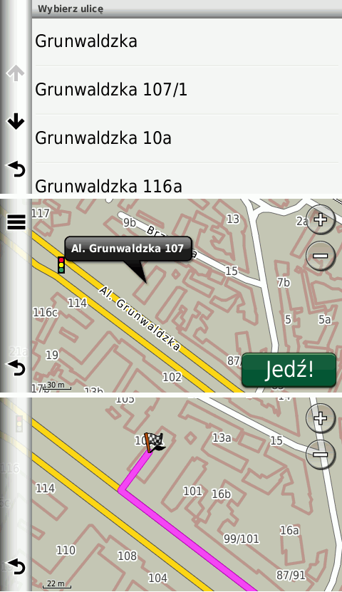
Hi Andrzej, I've created a road for each house number. The road contains two points with the coordinates of the house and a single number interval for that house. The address search works fine, but routing always draws a straight line between the houses (in MapSource) Gerd popej wrote
Hi Gerd,
routing doesn't work when I use the addresses as waypoints for the route :-(
I'm not sure what are you doing. I think Garmin can calculate a route through any points, regardless if they are on road or not. When using address point outside road, it calculate route to the nearest point on road and then straight line towards address. Maybe this doesn't work, if point is too far from any road?
I haven't tested it on single map, I have used non-routable transparent overlay with addresses and a routable map. In this configuration, nuvi calculate route as in attached picture.
-- Best regards, Andrzej
_______________________________________________ mkgmap-dev mailing list
mkgmap-dev@.org
http://www.mkgmap.org.uk/mailman/listinfo/mkgmap-dev
addr1.png (66K) <http://gis.19327.n5.nabble.com/attachment/5839896/0/addr1.png>;
-- View this message in context: http://gis.19327.n5.nabble.com/addr-place-support-tp5839721p5839897.html Sent from the Mkgmap Development mailing list archive at Nabble.com.
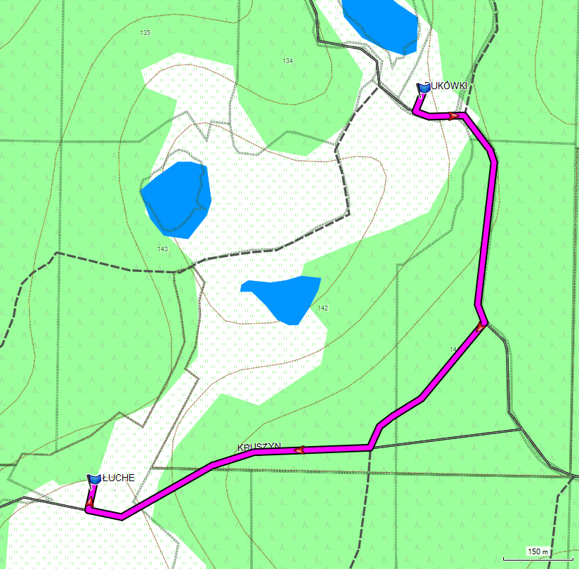
Hi Gerd, see attached picture from cgpsmapper map. I get this route in Mapsource this way: I start new route from Edit menu. I add 2 points using search address function. I click at "recalculate" button in route window. The only difference that I notice is that my addresses uses a non-zero length line, I create road which is about 10m. -- Best regards, Andrzej
Hi Andrzej, okay, I'll try again. I used a zero-length road because without a TYP file you will see short lines when I use e.g. 10m (using type 0x13, I am not aware of a type that is not rendered by default. But maybe the problem is not the length but an error in the img file. If I got you right, you are able to manipulate a routable map. Can you post links to the original one and the manipulated one? Gerd Date: Mon, 6 Apr 2015 14:59:36 +0200 From: popej@poczta.onet.pl To: mkgmap-dev@lists.mkgmap.org.uk Subject: Re: [mkgmap-dev] addr:place support Hi Gerd, see attached picture from cgpsmapper map. I get this route in Mapsource this way: I start new route from Edit menu. I add 2 points using search address function. I click at "recalculate" button in route window. The only difference that I notice is that my addresses uses a non-zero length line, I create road which is about 10m. -- Best regards, Andrzej _______________________________________________ mkgmap-dev mailing list mkgmap-dev@lists.mkgmap.org.uk http://www.mkgmap.org.uk/mailman/listinfo/mkgmap-dev
Hi Andrzej, I've tested different versions: 1) routable map created with r3521 2) routable map with additional zero-lentgh roads for each addr:place house number, roads NOT added to NOD 3) routable map with additional short roads for each addr:place house number, roads NOT added to NOD 4)routable map with additional short roads for each addr:place house number, roads ARE added to NOD My findings: routing works in all cases as long as I select points on the normal roads or close to them. Routing doesn't work (straight magenta line) when I select points which are closer to the pseudo-roads than to any normal road (versions 2-4), I think this is plausible, the routing algo searches for the closest road and tries to build a route to the other house, but that fails because it finds the pseudo roads which are not routable (2 and 3) or not connected to the road network (4). Gerd From: gpetermann_muenchen@hotmail.com To: mkgmap-dev@lists.mkgmap.org.uk Date: Tue, 7 Apr 2015 07:29:26 +0200 Subject: Re: [mkgmap-dev] addr:place support Hi Andrzej, okay, I'll try again. I used a zero-length road because without a TYP file you will see short lines when I use e.g. 10m (using type 0x13, I am not aware of a type that is not rendered by default. But maybe the problem is not the length but an error in the img file. If I got you right, you are able to manipulate a routable map. Can you post links to the original one and the manipulated one? Gerd Date: Mon, 6 Apr 2015 14:59:36 +0200 From: popej@poczta.onet.pl To: mkgmap-dev@lists.mkgmap.org.uk Subject: Re: [mkgmap-dev] addr:place support Hi Gerd, see attached picture from cgpsmapper map. I get this route in Mapsource this way: I start new route from Edit menu. I add 2 points using search address function. I click at "recalculate" button in route window. The only difference that I notice is that my addresses uses a non-zero length line, I create road which is about 10m. -- Best regards, Andrzej _______________________________________________ mkgmap-dev mailing list mkgmap-dev@lists.mkgmap.org.uk http://www.mkgmap.org.uk/mailman/listinfo/mkgmap-dev _______________________________________________ mkgmap-dev mailing list mkgmap-dev@lists.mkgmap.org.uk http://www.mkgmap.org.uk/mailman/listinfo/mkgmap-dev
Hi Gerd,
I think this is plausible, the routing algo searches for the closest road and tries to build a route to the other house, but that fails because it finds the pseudo roads which are not routable (2 and 3) or not connected to the road network (4).
This is not how Mapsource usually behave. Please try to use route tool from toolbar and click with it on 2 random points on the map. You should get a route on roads, even if you click outside road. I'm not sure about case 4 but 2 and 3 should work. In my opinion problem is somewhere else. Please create a route in case 2-4 and then try to recalculate it changing map to case 1 (standard compilation). -- Best regards, Andrzej

On Tue, Apr 07, Andrzej Popowski wrote:
Hi Gerd,
I think this is plausible, the routing algo searches for the closest road and tries to build a route to the other house, but that fails because it finds the pseudo roads which are not routable (2 and 3) or not connected to the road network (4).
This is not how Mapsource usually behave.
I don't know about Mapsource, but this is how the Garmin GPSMap 62s behaves. It is looking for the nearest "road", whatever this is, and tries to route from that. If this "nearest road" is not connected, you will get a routing error. Your example with two points only works, if the closest road is routeable and connected. Thorsten -- Thorsten Kukuk, Senior Architect SLES & Common Code Base SUSE LINUX GmbH, Maxfeldstr. 5, 90409 Nuernberg, Germany GF: Felix Imendörffer, Jane Smithard, Jennifer Guild, Dilip Upmanyu, Graham Norton, HRB 21284 (AG Nürnberg)
Hi Thorsten,
I don't know about Mapsource, but this is how the Garmin GPSMap 62s behaves. It is looking for the nearest "road", whatever this is, and tries to route from that. If this "nearest road" is not connected, you will get a routing error.
I know about this. There is some distance range form current position, where should be a routable road to begin a routing. Maybe the same distance limit is in effect for point addressing, but it doesn't explain total failure of Gerd's new function in Mapsource. I can only repeat, Mapsource doesn't behave that way, see the picture, that I have attached some mails ago. This is exactly the same case, a road created between 2 address points on short non-routable artificial roads. The only difference is that map is created with cgpsmapper. Maybe new code still creates routable ways for address points? It could lead to straight routes, if road network is discontinuous. -- Best regards, Andrzej
Hi Andrzej,
Maybe new code still creates routable ways for address points? It could lead to straight routes, if road network is discontinuous.
Maybe, that's why I asked for samples this morning: http://gis.19327.n5.nabble.com/addr-place-support-tp5839721p5839936.html Gerd
Hi Gerd,
that's why I asked for samples this morning
Sorry, I missed your request. Maybe because I don't manipulate maps ;) This is a straight compilation by cgpsmapper, where I add short non-routable road for each city in mp source. I have quoted example in previous mail. I can try to create a simple map with similar case. -- Best regards, Andrzej
Hi Andrzej, don't invest too much time in this, I am making good progress with the solution that uses the normal roads. I have to solve a few more special cases, but the obvious advantage of the "normal" solution is the much smaller img size. With my test tile in Czech Republic I see 4.406 KB without addr:place support, 4.411 with "normal" solution (probably ~ 4.420 when all special cases are solved), 4.611 KB with the "zero-length roads" for each hose. Gerd
Date: Tue, 7 Apr 2015 18:27:05 +0200 From: popej@poczta.onet.pl To: mkgmap-dev@lists.mkgmap.org.uk Subject: Re: [mkgmap-dev] addr:place support
Hi Gerd,
that's why I asked for samples this morning
Sorry, I missed your request. Maybe because I don't manipulate maps ;)
This is a straight compilation by cgpsmapper, where I add short non-routable road for each city in mp source. I have quoted example in previous mail.
I can try to create a simple map with similar case.
-- Best regards, Andrzej _______________________________________________ mkgmap-dev mailing list mkgmap-dev@lists.mkgmap.org.uk http://www.mkgmap.org.uk/mailman/listinfo/mkgmap-dev
Hi Gerd, problem is interesting, I gladly investigate. I can confirm, that there is maximum distance off road, where Mapsource still finds routing on road. Could be like 100-150m. I have created a single example of map with point addressing. It consist of 2 routable roads and 4 non-routable roads for addresses. Address search works. You can get a proper route between points 1-3, but point 4 is too far and Mapsource uses straight line to it. You can decompile map with GPSMapEdit and check, which roads are routable, Attached archive contains mapset for Mapsource. -- Best regards, Andrzej
Hi Andrzej, I don't know how to use the files in MapSource without an installer. Tried to modify an existing nsi file, but that doesn't work :( Gerd Date: Tue, 7 Apr 2015 19:38:24 +0200 From: popej@poczta.onet.pl To: mkgmap-dev@lists.mkgmap.org.uk Subject: Re: [mkgmap-dev] addr:place support Hi Gerd, problem is interesting, I gladly investigate. I can confirm, that there is maximum distance off road, where Mapsource still finds routing on road. Could be like 100-150m. I have created a single example of map with point addressing. It consist of 2 routable roads and 4 non-routable roads for addresses. Address search works. You can get a proper route between points 1-3, but point 4 is too far and Mapsource uses straight line to it. You can decompile map with GPSMapEdit and check, which roads are routable, Attached archive contains mapset for Mapsource. -- Best regards, Andrzej _______________________________________________ mkgmap-dev mailing list mkgmap-dev@lists.mkgmap.org.uk http://www.mkgmap.org.uk/mailman/listinfo/mkgmap-dev
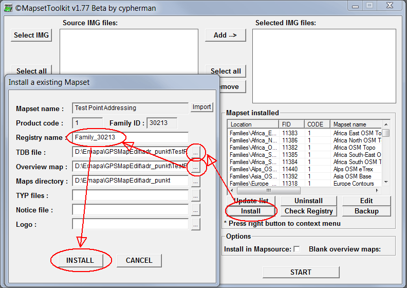
Hi Gerd, I'm using MapSetToolKit for managing maps: https://sites.google.com/site/cypherman1/ See attached picture for instruction. -- Best regards, Andrzej
Hi Andrzej, thanks for the hint, I was now able to install your test map. I think it doesn't contain the problem case I was hitting: Think of 5 houses in the same pattern as on a dice, and this group is ~30m away from the road Try to create a route to house in the middle. Or more general: If you have to buildings on the same side of the road so that distance between the houses is smaller than the distance to the road, MapSource will select the pseudo road. Gerd Date: Tue, 7 Apr 2015 22:35:43 +0200 From: popej@poczta.onet.pl To: mkgmap-dev@lists.mkgmap.org.uk Subject: Re: [mkgmap-dev] addr:place support Hi Gerd, I'm using MapSetToolKit for managing maps: https://sites.google.com/site/cypherman1/ See attached picture for instruction. -- Best regards, Andrzej _______________________________________________ mkgmap-dev mailing list mkgmap-dev@lists.mkgmap.org.uk http://www.mkgmap.org.uk/mailman/listinfo/mkgmap-dev
Hi Gerd,
If you have to buildings on the same side of the road so that distance between the houses is smaller than the distance to the road, MapSource will select the pseudo road.
I confirm, this doesn't work in Mapsource. Probably there is some influence of NET on routing. Isn't it NET, where information about crossroads is held? I have prepared a mapset, where address points are placed in separate, transparent img. Now routing works, not only in the case you have described but for points in greater distance from roads too. Please try attached map, you can simply overwrite previous files. Try a route like: Point One 2 - Point Four 4 - Point Two 3. -- Best regards, Andrzej
Hi Andrzej, I see that this works, but I think we cannot use it as a general solution. It doesn't require much code to generate the pseudo roads, so maybe it is something for a special option. One open problem: Although the wiki says that either addr:place or addr:street should be used I see many nodes with both. I see two solutions: 1) If both are given, ignore the address (as we do now if none is given) 2) Use addr:place for address search and use the addr:street info to make sure that the house is attached to the corresponding street. I prefer 2) BTW: It would also be easy now to handle the addresses that have only addr:housenumber set. WanMil said we should not do that, but I see no good reason to ignore information when it is easy to use. Gerd Date: Wed, 8 Apr 2015 13:03:18 +0200 From: popej@poczta.onet.pl To: mkgmap-dev@lists.mkgmap.org.uk Subject: Re: [mkgmap-dev] addr:place support Hi Gerd,
If you have to buildings on the same side of the road so that distance between the houses is smaller than the distance to the road, MapSource will select the pseudo road.
I confirm, this doesn't work in Mapsource. Probably there is some influence of NET on routing. Isn't it NET, where information about crossroads is held? I have prepared a mapset, where address points are placed in separate, transparent img. Now routing works, not only in the case you have described but for points in greater distance from roads too. Please try attached map, you can simply overwrite previous files. Try a route like: Point One 2 - Point Four 4 - Point Two 3. -- Best regards, Andrzej _______________________________________________ mkgmap-dev mailing list mkgmap-dev@lists.mkgmap.org.uk http://www.mkgmap.org.uk/mailman/listinfo/mkgmap-dev
Hi Gerd,
It doesn't require much code to generate the pseudo roads, so maybe it is something for a special option.
Would be nice, if you preserve this code. Maybe even for all addresses, not only for addr:place? But actually I can extract addresses form OSM sources, parse them, convert to roads and get the same result. Either way, I'm glad, that we have found what works and what has to be avoided.
Although the wiki says that either addr:place or addr:street should be used I see many nodes with both.
IMHO use addr:street and ignore addr:place. Most probably addr:place is incorrectly set instead of addr:city, which you get from other data anyway.
I see no good reason to ignore information when it is easy to use.
Yes, I know the feeling, never refuse free data ;) -- Best regards, Andrzej
Hi Andrzej,
It doesn't require much code to generate the pseudo roads, so maybe it is something for a special option.
Would be nice, if you preserve this code. Maybe even for all addresses, not only for addr:place? But actually I can extract addresses form OSM sources, parse them, convert to roads and get the same result. Either way, I'm glad, that we have found what works and what has to be avoided.
Okay. Let's first sort out how to fill the address info.
Although the wiki says that either addr:place or addr:street should be used I see many nodes with both.
IMHO use addr:street and ignore addr:place. Most probably addr:place is incorrectly set instead of addr:city, which you get from other data anyway.
OK, I'll do some statistics to find some good rules. My idea is to collect the numbers with equal addr:place tag. If there are not too many duplicates in different positions I assume that the place name should be used for the address and addr:street should only be used to identify the right road. That's what I am now trying to code. Gerd
On Thu, Apr 09, Andrzej Popowski wrote:
Although the wiki says that either addr:place or addr:street should be used I see many nodes with both.
IMHO use addr:street and ignore addr:place. Most probably addr:place is incorrectly set instead of addr:city, which you get from other data anyway.
I think this is a problem of some editors, which asks for all of this keys, and people think they need to fill out every field. If we have addr:place and addr:street, I would ignore addr:place, too. Thorsten -- Thorsten Kukuk, Senior Architect SLES & Common Code Base SUSE LINUX GmbH, Maxfeldstr. 5, 90409 Nuernberg, Germany GF: Felix Imendörffer, Jane Smithard, Jennifer Guild, Dilip Upmanyu, Graham Norton, HRB 21284 (AG Nürnberg)
Although the wiki says that either addr:place or addr:street should be used I see many nodes with both.
IMHO use addr:street and ignore addr:place. Most probably addr:place is incorrectly set instead of addr:city, which you get from other data anyway.
I think this is a problem of some editors, which asks for all of this keys, and people think they need to fill out every field.
If we have addr:place and addr:street, I would ignore addr:place, too.
Okay, I will consider this. I see many places in CZ where some houses have addr:street=* but also many have not, while all of them have the same addr:place value. Look at Bubovice in CZ for example: http://www.openstreetmap.org/relation/442330 Results for Overpass queries with addr:housenumber=* and addr:place=* and addr:street=* in Bubovice : 87 nodes addr:housenumber=* and addr:place=* and addr:street!=* in Bubovice : 114 nodes In this case most streets have names, so I think mkgmap should try to find the closest road and use the road name for the address. The current code in r3529 treats the numbers with addr:street separated from the others and adds the label Bubovice to the roads so that the search for the houses without addr:street works. That makes no sense here. Gerd

Gerd Petermann <gpetermann_muenchen@hotmail.com> writes:
I've coded the following simple approach: For each element (node/way) with addr:housenumber=* and addr:place=* and addr:street!=* search the nearest routable way that has no name (mkgmap:street!=*) If the closest road is within a given range (150m), store the place name as a possible road name. Perform a 2nd search to find also the closest road with a name or ref. If we find exactly one possible name for the road, use it.
I really don't understand what's going on here, but this strikes me as strange; an address node with housenumber and place isn't about a street. Is the problem that in the Garmin format that the only way to represent an address is via a road? I wonder if there's a way to have short non-rendered non-routable segments of roads to hang the addresses on.

On Sat, Apr 04, 2015 at 03:03:47PM +0200, Gerd Petermann wrote:
Hi all,
some month ago we discussed the idea to implement addr:place support. It it assumed that an address has addr:housenumber and either addr:place or addr:street. Up to now those with addr:place are ignored. It is also assumed that the addr:place tag is used in hamlets and small villages and that the roads in such a hamlet have no name.
I've coded the following simple approach: For each element (node/way) with addr:housenumber=* and addr:place=* and addr:street!=* search the nearest routable way that has no name (mkgmap:street!=*) If the closest road is within a given range (150m), store the place name as a possible road name. Perform a 2nd search to find also the closest road with a name or ref. If we find exactly one possible name for the road, use it.
As a small example - I have a small Hamlet here called Bosfeld beloning to a town called Rheda-Wiedenbrück with a suburb of Rheda. The main street through Bosfeld is called "Bosfelder Weg" although all adresses are "Bosfeld 1" through 60 or something. So mkgmap:street!=* will be wrong in finding the next routable way. Flo -- Florian Lohoff f@zz.de We need to self-defense - GnuPG/PGP enable your email today!
Hi Florian, what would be the solution for this case? Should mkgmap change the name to Bosfeld for the part of "Bosfelder Weg" that runs through Bosfeld ? That would mean something like roate the four labels so that the last is lost and put Bosfeld as first label. I seem to remember similar cases in other hamlets, so maybe we can use this as a general rule? Gerd Florian Lohoff-2 wrote
On Sat, Apr 04, 2015 at 03:03:47PM +0200, Gerd Petermann wrote:
Hi all,
some month ago we discussed the idea to implement addr:place support. It it assumed that an address has addr:housenumber and either addr:place or addr:street. Up to now those with addr:place are ignored. It is also assumed that the addr:place tag is used in hamlets and small villages and that the roads in such a hamlet have no name.
I've coded the following simple approach: For each element (node/way) with addr:housenumber=* and addr:place=* and addr:street!=* search the nearest routable way that has no name (mkgmap:street!=*) If the closest road is within a given range (150m), store the place name as a possible road name. Perform a 2nd search to find also the closest road with a name or ref. If we find exactly one possible name for the road, use it.
As a small example - I have a small Hamlet here called Bosfeld beloning to a town called Rheda-Wiedenbrück with a suburb of Rheda.
The main street through Bosfeld is called "Bosfelder Weg" although all adresses are "Bosfeld 1" through 60 or something.
So mkgmap:street!=* will be wrong in finding the next routable way.
Flo -- Florian Lohoff
f@
We need to self-defense - GnuPG/PGP enable your email today!
_______________________________________________ mkgmap-dev mailing list
mkgmap-dev@.org
http://www.mkgmap.org.uk/mailman/listinfo/mkgmap-dev
signature.asc (845 bytes) <http://gis.19327.n5.nabble.com/attachment/5839774/0/signature.asc>;
-- View this message in context: http://gis.19327.n5.nabble.com/addr-place-support-tp5839721p5839777.html Sent from the Mkgmap Development mailing list archive at Nabble.com.
participants (6)
-
 Andrzej Popowski
 -
 Florian Lohoff
 -
 Gerd Petermann
 -
GerdP
-
 Greg Troxel
 -
 Thorsten Kukuk