Bounds problem with streets

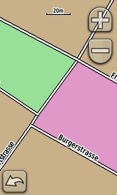
Hello, i have attached a screenshot of my Oregon to explain the problem. As you can see, the streets are not "connected" correct. I have made the map with a self made typ file and an extracted OSM file. Is there a special attribute i must set, when i compile the IMG file, or how can i solve the problem? Greetz, Tim

If they are not connected correctly (no routing over it), then the error is in Openstreetmap - where the roads are also not connected. On 02.03.2010 23:14, Tim wrote:
Hello,
i have attached a screenshot of my Oregon to explain the problem. As you can see, the streets are not "connected" correct. I have made the map with a self made typ file and an extracted OSM file. Is there a special attribute i must set, when i compile the IMG file, or how can i solve the problem?
Greetz, Tim
_______________________________________________ mkgmap-dev mailing list mkgmap-dev@lists.mkgmap.org.uk http://www.mkgmap.org.uk/mailman/listinfo/mkgmap-dev

Felix Hartmann schrieb:
If they are not connected correctly (no routing over it), then the error is in Openstreetmap - where the roads are also not connected.
On 02.03.2010 23:14, Tim wrote:
i have attached a screenshot of my Oregon to explain the problem. As you can see, the streets are not "connected" correct. I have made the map with a self made typ file and an extracted OSM file. Is there a special attribute i must set, when i compile the IMG file, or how can i solve the problem?
I don't see a connection problem there: <http://www.openstreetmap.org/?lat=52.388165&lon=9.746414&zoom=18> So I assume it's display-problem of the oregon. Chris
participants (3)
-
 Chris-Hein Lunkhusen
 -
 Felix Hartmann
 -
 Tim
Tim