what do the 0x4a polygon in the mean?

Hi experts, today I played with a map that has non-rectangular shape. I tried this: Use the dem-poly option to cut also the 0x4b polygon for each tile, use these 0x4b polygons also in the overview map and also for 0x4a in the overview map. I expected that this would create nicer maps but found no effect in MapSource. I tried this with the sample from Andrzej. The DEM data in the Winterkarte does not show the steps which are produced by mkgmap at polygon boundary. What am I doing wrong? Gerd

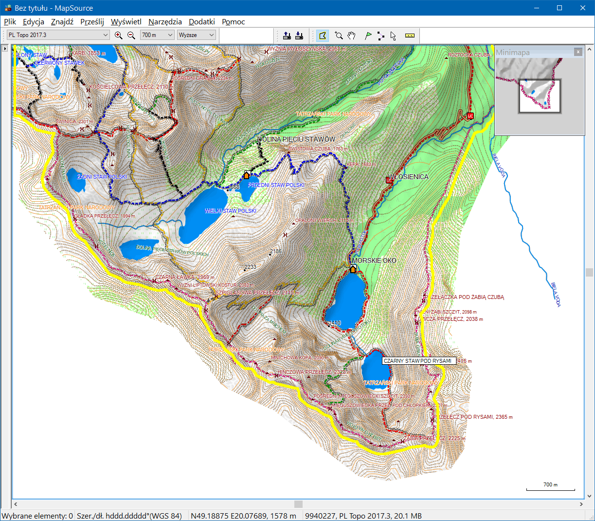
Hi Gerd, have you remembered to press Ctr-G twice? ;) I'm sure that you can get expected result. Detailed tile should have its background 4B clipped and the same shape should be used for 4A and 4B of overview map. I'm attaching a screenshot from a map created with cGPSmapper and with DEM supplied by BuildDEMFile. See, that background of detailed tile is the limit of DEM shading and also shown as a selection for map transfer. -- Best regards, Andrzej
Hi Andrezj, okay, I'll try again tomorrow. Gerd ________________________________________ Von: mkgmap-dev <mkgmap-dev-bounces@lists.mkgmap.org.uk> im Auftrag von Andrzej Popowski <popej@poczta.onet.pl> Gesendet: Freitag, 12. Januar 2018 20:36:03 An: mkgmap-dev@lists.mkgmap.org.uk Betreff: Re: [mkgmap-dev] what do the 0x4a polygon in the mean? Hi Gerd, have you remembered to press Ctr-G twice? ;) I'm sure that you can get expected result. Detailed tile should have its background 4B clipped and the same shape should be used for 4A and 4B of overview map. I'm attaching a screenshot from a map created with cGPSmapper and with DEM supplied by BuildDEMFile. See, that background of detailed tile is the limit of DEM shading and also shown as a selection for map transfer. -- Best regards, Andrzej
Hi Andrzej, hmm, still not much success. It seems that my problem is caused by the DEM data of the overview map. Garmins "Winterkarte" doesn't have an overview map, right? Maybe I have to write an additonal 0x4a polygon for the overview map itself? Gerd ________________________________________ Von: mkgmap-dev <mkgmap-dev-bounces@lists.mkgmap.org.uk> im Auftrag von Gerd Petermann <gpetermann_muenchen@hotmail.com> Gesendet: Freitag, 12. Januar 2018 21:35:18 An: Development list for mkgmap Betreff: Re: [mkgmap-dev] what do the 0x4a polygon in the mean? Hi Andrezj, okay, I'll try again tomorrow. Gerd ________________________________________ Von: mkgmap-dev <mkgmap-dev-bounces@lists.mkgmap.org.uk> im Auftrag von Andrzej Popowski <popej@poczta.onet.pl> Gesendet: Freitag, 12. Januar 2018 20:36:03 An: mkgmap-dev@lists.mkgmap.org.uk Betreff: Re: [mkgmap-dev] what do the 0x4a polygon in the mean? Hi Gerd, have you remembered to press Ctr-G twice? ;) I'm sure that you can get expected result. Detailed tile should have its background 4B clipped and the same shape should be used for 4A and 4B of overview map. I'm attaching a screenshot from a map created with cGPSmapper and with DEM supplied by BuildDEMFile. See, that background of detailed tile is the limit of DEM shading and also shown as a selection for map transfer. -- Best regards, Andrzej _______________________________________________ mkgmap-dev mailing list mkgmap-dev@lists.mkgmap.org.uk http://www.mkgmap.org.uk/mailman/listinfo/mkgmap-dev
Hi Gerd, I don't think that any changes in overview are needed. If you zoom into detailed map, then overview is unimportant. I have installed Winter Activity Map in Mapsource using GMapTool. The overview map is very simplified, it contains objects 4A and 4B as rectangles and no DEM. Still I can see clipped shading and irregular borders for selecting maps. Could you upload your examples? -- Best regards, Andrzej
Hi Andrzej, see http://files.mkgmap.org.uk/download/390/OSM%20map.gmap.zip The map was created with your data, the attached experimental patch and options --dem-poly=e:\baddem\poland.poly --dem=e:\baddem\SRTM --code-page=1252 --dem-dists=9942 --overview-dem-dist=30000 --gmapi --show-profiles=1 --preserve-element-order e:\baddem\29483085.osm.pbf If you use it as is the DEM data of the overview map overlaps the 0x4a polygon. If you rename or remove OSM map.gmap\Product1\osmmap\63240000.DEM the result looks quite good. Gerd ________________________________________ Von: mkgmap-dev <mkgmap-dev-bounces@lists.mkgmap.org.uk> im Auftrag von Andrzej Popowski <popej@poczta.onet.pl> Gesendet: Samstag, 13. Januar 2018 13:04:23 An: mkgmap-dev@lists.mkgmap.org.uk Betreff: Re: [mkgmap-dev] what do the 0x4a polygon in the mean? Hi Gerd, I don't think that any changes in overview are needed. If you zoom into detailed map, then overview is unimportant. I have installed Winter Activity Map in Mapsource using GMapTool. The overview map is very simplified, it contains objects 4A and 4B as rectangles and no DEM. Still I can see clipped shading and irregular borders for selecting maps. Could you upload your examples? -- Best regards, Andrzej _______________________________________________ mkgmap-dev mailing list mkgmap-dev@lists.mkgmap.org.uk http://www.mkgmap.org.uk/mailman/listinfo/mkgmap-dev
Hi Gerd, now I get the problem. What you see is DEM from overview map. I don't think you can remove that. I have looked at available Garmin maps to compare, and there are 3 solution: - Leave jagged DEM, overview map covers a bit more area, so jagged border is like 700m from tile background. - Create complete DEM outside map area. - Add empty DEM to overview map, so it disappears when zooming out. -- Best regards, Andrzej
Hi Andrzej, I don't understand the solutions :-( My problem is that the jagged data from the overview map doesn't disappear when I zoom in near the boundary. My ideas: 1) don't add DEM to overview map (a work around) 2) use a slightly smaller polygon when calculating DEM for overview map, so that the nicer data from the tiles covers the jagged data when zooming in. 3) Find a flag or something else that tells the PC program that it should stop rendering the overview DEM at some level. Is there any match? Gerd ________________________________________ Von: mkgmap-dev <mkgmap-dev-bounces@lists.mkgmap.org.uk> im Auftrag von Andrzej Popowski <popej@poczta.onet.pl> Gesendet: Samstag, 13. Januar 2018 15:10:46 An: mkgmap-dev@lists.mkgmap.org.uk Betreff: Re: [mkgmap-dev] what do the 0x4a polygon in the mean? Hi Gerd, now I get the problem. What you see is DEM from overview map. I don't think you can remove that. I have looked at available Garmin maps to compare, and there are 3 solution: - Leave jagged DEM, overview map covers a bit more area, so jagged border is like 700m from tile background. - Create complete DEM outside map area. - Add empty DEM to overview map, so it disappears when zooming out. -- Best regards, Andrzej _______________________________________________ mkgmap-dev mailing list mkgmap-dev@lists.mkgmap.org.uk http://www.mkgmap.org.uk/mailman/listinfo/mkgmap-dev
Hi Gerd,
1) don't add DEM to overview map (a work around)
Maybe it would work, but I remember getting problems with overview without DEM (I forgot what it was, maybe even not because of DEM?). I think it would be better to add what I call "empty DEM" instead. The empty DEM layer contains 4 bytes of data: 0 0 0 2 Header of a layer is the same, tiles are 64*64, but there is no tiles, only extra rows and columns. Word defining structure (recordDesc) is 0x10 00. Number of rows and columns is small, like for example 4, and distance between points is big. You can see this in Adria Topo. There is update here, which can be installed on PC (including Mapsource): http://www.garminbh.ba/Default.aspx?sifraStranica=354&kultura=en Link to map doesn't work because of redirections, but you can extract final address from link and download map. You can even browse map in Mapsource, if you provide unlock key: DEMO
2) use a slightly smaller polygon
This is other solution of Garmin, but they use bigger polygon in overview, increased by about 700m outside. So jaggies are far from map details.
3) Find a flag or something else that tells the PC program that it should stop rendering the overview DEM at some level.
I doubt it is possible. -- Best regards, Andrzej
Hi Andrzej, thanks for the hints. It seems indeed to be an alternative to use a very large overview-dem-dist value in combination with no DEM data. Garmin uses this in the "Winterkarte" and in the Adria Map. Also, the overview map of "Winterkarte" is the first map that I found in which dem-dist for lat and lon ar different: map units between points (latitude): 86517760 map units between points (longitude): 205701120 Maybe I change meaning of option --overview-dem-dist=0 to produce this special small DEM file instead of no DEM. Gerd ________________________________________ Von: mkgmap-dev <mkgmap-dev-bounces@lists.mkgmap.org.uk> im Auftrag von Andrzej Popowski <popej@poczta.onet.pl> Gesendet: Samstag, 13. Januar 2018 17:24:35 An: mkgmap-dev@lists.mkgmap.org.uk Betreff: Re: [mkgmap-dev] what do the 0x4a polygon in the mean? Hi Gerd,
1) don't add DEM to overview map (a work around)
Maybe it would work, but I remember getting problems with overview without DEM (I forgot what it was, maybe even not because of DEM?). I think it would be better to add what I call "empty DEM" instead. The empty DEM layer contains 4 bytes of data: 0 0 0 2 Header of a layer is the same, tiles are 64*64, but there is no tiles, only extra rows and columns. Word defining structure (recordDesc) is 0x10 00. Number of rows and columns is small, like for example 4, and distance between points is big. You can see this in Adria Topo. There is update here, which can be installed on PC (including Mapsource): http://www.garminbh.ba/Default.aspx?sifraStranica=354&kultura=en Link to map doesn't work because of redirections, but you can extract final address from link and download map. You can even browse map in Mapsource, if you provide unlock key: DEMO
2) use a slightly smaller polygon
This is other solution of Garmin, but they use bigger polygon in overview, increased by about 700m outside. So jaggies are far from map details.
3) Find a flag or something else that tells the PC program that it should stop rendering the overview DEM at some level.
I doubt it is possible. -- Best regards, Andrzej _______________________________________________ mkgmap-dev mailing list mkgmap-dev@lists.mkgmap.org.uk http://www.mkgmap.org.uk/mailman/listinfo/mkgmap-dev
Hi Gerd, do you have overview for Winter Activity Map? I have never seen Winter map for PC, only gmapsupp.img. Maybe it is an overview created by GMapTool, check copyright in TRE. I have included procedure for creating empty DEM in GMapTool, which is using different distances. Actually it used to create too big area of DEM, I have just released correction. You shouldn't use it as reference. -- Best regards, Andrzej
Hi Andrzej, ah, okay, so I looked at the DEM data created by GMapTool. I already wondered where this came from ;-) So forget those findings for Winter Activity Map. Still, Adria map seems to use the same trick, just not so strange values. Gerd ________________________________________ Von: mkgmap-dev <mkgmap-dev-bounces@lists.mkgmap.org.uk> im Auftrag von Andrzej Popowski <popej@poczta.onet.pl> Gesendet: Sonntag, 14. Januar 2018 11:49:24 An: mkgmap-dev@lists.mkgmap.org.uk Betreff: Re: [mkgmap-dev] what do the 0x4a polygon in the mean? Hi Gerd, do you have overview for Winter Activity Map? I have never seen Winter map for PC, only gmapsupp.img. Maybe it is an overview created by GMapTool, check copyright in TRE. I have included procedure for creating empty DEM in GMapTool, which is using different distances. Actually it used to create too big area of DEM, I have just released correction. You shouldn't use it as reference. -- Best regards, Andrzej _______________________________________________ mkgmap-dev mailing list mkgmap-dev@lists.mkgmap.org.uk http://www.mkgmap.org.uk/mailman/listinfo/mkgmap-dev
participants (3)
-
 Andrzej Popowski
 -
 Gerd Petermann
 -
Gerd Petermann