[PATCH v4] alpha support for motorway exits and service areas

Patch version 4 (based on r974) - misc fixes ---------------------- Hi, The attached patch provides basic support for processing motorway exits. It's still work in progress but I am posting it so that people can try it out, find what breaks and suggest improvements. Exits in the garmin world have to be associated with a motorway (sounds reasonable) but they don't have to coincide with a node on the motorway, i.e. the exit node doesn't have to be on the motorway! In the case where the exit is defined with a "motorway_junction" tag on one of the motorway's nodes, nothing needs to be done for an exit POI to be generated as mkgmap will work out the association itself (only for roads that are "motorway" or "trunk"). If your "motorway_junction" node is separate from the motorway (not very sensible, perhaps) or you are using a "highway=services" tag on a node (which probably will be near the road but not actually on it) you will need to add a "exit:road_ref" tag to specify the reference of the road that the exit is associated with. Here's example tags that associates a services with the road A41. name=Toy Town Services highway=services exit:road_ref=A41 Note, at this time "highway=services" for areas is not yet supported. Seems to me that it could be by using the new area POIs functionality to make a POI automatically. One attribute of exits is that they exit to somewhere and you need to be able to specify where the exit is going to because mkgmap can't guess that (well, not yet, anyway). To do this, use an "exit:to" tag. So you can say: highway=motorway_junction ref=5 exit:to=Telford East Garmin allow you to specify all sorts of facilities info for an exit and this is described in the cgpsmapper docs. Of course, there is no standard OSM means to express that so we have yet another tag "exit:facility" that should be set to a comma separated set of values that describe the facility. The syntax is exactly the same as used in mp files. Something like this (values are examples, not sensible): exit:facility=0x01,N,0x04,Hello World Yet more flexibility is introduced by the fact that the type code for the exit can be one of a huge range. At the moment, I am using: highway=motorway_junction { name '${ref} ${name}' | '${ref}' | '${name}' } highway=motorway_junction [0x2000 resolution 16] highway=services { name '${ref} ${name}' | '${ref}' | '${name}' } highway=services [0x210f resolution 16] 0x2000 means "exit no services" 0x210f means "exit (service") I played around with the codes and on my gps some codes make little symbols appear to show that the exit has food, hotel, etc. We can probably make it use a suitable code from the facilities info but I haven't looked into that yet. Oh yes, you must have a region defined for your map, if you don't, the exits will not be generated. One disappointment. So far, I have not yet been able to make the exits findable. I am working on that aspect but don't know when I will succeed. All feedback is welcome. Cheers, Mark

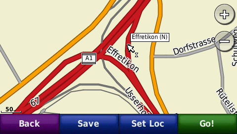
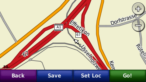
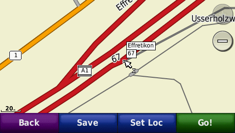
Mark, Still no luck with exit announcements on my Nuvi. I had a closer look at the pre-installed Garmin Map (NT 2008 Europe) and made some (interesting?) discoveries (see attached screenshots): - On this specific motorway-junction, only the ramp for leaving the motorway is 'tagged' as ramp (screenshot 1, thin gray line). However, on other junctions, the entering ramp is 'tagged' correctly. - The ramp for entering the motorway is named after the place where the junction is located (screenshot 1, Effretikon). This seems to only be the case if the entering ramp is 'tagged' as motorway (big red line) - The ramps leaving the motorway are labeled with the corresponding exit-# (screenshot 2, '67') - The exit POI is where one would expect it (screenshot 3) Not sure what to make out of this, but maybe it would be worth rearranging this specific junction in OSM to match the Garmin map and see what effects on the produced routing instructions this will have?!? Cheers, - Michel
Hi Michel, Thanks for the pictures. To help me understand them, I would like to see the OSM source for this junction, please post the URL for that location. Cheers, Mark
Mark,
Thanks for the pictures.
To help me understand them, I would like to see the OSM source for this junction, please post the URL for that location.
http://www.openstreetmap.org/?lat=47.44211&lon=8.69506&zoom=16&layers=B000FT...
participants (2)
-
 Mark Burton
 -
 Michel Marti