Rendering Error at Region FR-Saint Maximin la Sainte Baume and around Gibraltar

Hallo i'm not quite sure, if this error is related to mkgmap or the OSM-Database. Just fiddling around making maps for my garmin device. The last three times, when i compiled my europe map, i have to discover two errors. The region around Gibraltar will not show up the mediterranian sea but the underlying terrain will show up as "unknown terrain". This error is only about 80 km around Gibraltar with Gibraltar nearly in the center. The other error is in the vicinity of the area called by splitter FR-Saint Maximin la Sainte Baume. At this complete square the default terrain layer is not compiled as undefined area but as sea. Any idea, if these errors are due to mkgmap or osm database ? -- Mit freundlichen Grüßen ##################################################### Manfred Haiduk, Zum Fischbach 9, 52393 Hürtgenwald e-mail mhaiduk@t-online.de #####################################################

Hi Manfred, sorry, I don't understand the problem. Do you think that splitter (or more precisely the --geonames-file option) sets wrong description values for the tiles in template.args ? Maybe you can post links to a few screenshots that show what you are talking about? Gerd ________________________________________ Von: mkgmap-dev <mkgmap-dev-bounces@lists.mkgmap.org.uk> im Auftrag von Manfred Haiduk <mhaiduk@t-online.de> Gesendet: Donnerstag, 9. November 2017 17:11:47 An: mkgmap-dev@lists.mkgmap.org.uk Betreff: [mkgmap-dev] Rendering Error at Region FR-Saint Maximin la Sainte Baume and around Gibraltar Hallo i'm not quite sure, if this error is related to mkgmap or the OSM-Database. Just fiddling around making maps for my garmin device. The last three times, when i compiled my europe map, i have to discover two errors. The region around Gibraltar will not show up the mediterranian sea but the underlying terrain will show up as "unknown terrain". This error is only about 80 km around Gibraltar with Gibraltar nearly in the center. The other error is in the vicinity of the area called by splitter FR-Saint Maximin la Sainte Baume. At this complete square the default terrain layer is not compiled as undefined area but as sea. Any idea, if these errors are due to mkgmap or osm database ? -- Mit freundlichen Grüßen ##################################################### Manfred Haiduk, Zum Fischbach 9, 52393 Hürtgenwald e-mail mhaiduk@t-online.de ##################################################### _______________________________________________ mkgmap-dev mailing list mkgmap-dev@lists.mkgmap.org.uk http://www.mkgmap.org.uk/mailman/listinfo/mkgmap-dev
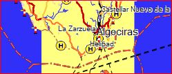
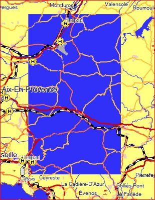
Uhh, its a quick response to my question. Now i've added two screenshots from MapSource for these two regions. And its not only MapSource, who shows the error, but also BAseCamp and the Garmin Device GPSMap 276Cx. According the picture "Gibraltar", you will see, that instead of the blue sea i.e in the harbour of algeciras the polygon is rendered in the default terrein colour. And for the area "france error" its vice versa, instead of terrein there is the colour of the blue sea. I tried to figure out with the help of the JOSM editor, what type of background polygon is used, but as i'm a newbee for this editor, i was not able to catch the background polygon Am 09.11.2017 um 17:24 schrieb Gerd Petermann:
Hi Manfred, sorry, I don't understand the problem. Do you think that splitter (or more precisely the --geonames-file option) sets wrong description values for the tiles in template.args ? Maybe you can post links to a few screenshots that show what you are talking about?
Gerd
________________________________________ Von: mkgmap-dev <mkgmap-dev-bounces@lists.mkgmap.org.uk> im Auftrag von Manfred Haiduk <mhaiduk@t-online.de> Gesendet: Donnerstag, 9. November 2017 17:11:47 An: mkgmap-dev@lists.mkgmap.org.uk Betreff: [mkgmap-dev] Rendering Error at Region FR-Saint Maximin la Sainte Baume and around Gibraltar
Hallo
i'm not quite sure, if this error is related to mkgmap or the OSM-Database. Just fiddling around making maps for my garmin device. The last three times, when i compiled my europe map, i have to discover two errors. The region around Gibraltar will not show up the mediterranian sea but the underlying terrain will show up as "unknown terrain". This error is only about 80 km around Gibraltar with Gibraltar nearly in the center. The other error is in the vicinity of the area called by splitter FR-Saint Maximin la Sainte Baume. At this complete square the default terrain layer is not compiled as undefined area but as sea. Any idea, if these errors are due to mkgmap or osm database ?
--
Mit freundlichen Grüßen
##################################################### Manfred Haiduk, Zum Fischbach 9, 52393 Hürtgenwald e-mail mhaiduk@t-online.de #####################################################
_______________________________________________ mkgmap-dev mailing list mkgmap-dev@lists.mkgmap.org.uk http://www.mkgmap.org.uk/mailman/listinfo/mkgmap-dev
-- Mit freundlichen Grüßen ##################################################### Manfred Haiduk, Zum Fischbach 9, 52393 Hürtgenwald e-mail mhaiduk@t-online.de #####################################################
participants (2)
-
 Gerd Petermann
 -
 Manfred Haiduk