[PATCH] Enable elevation profile in MapSource

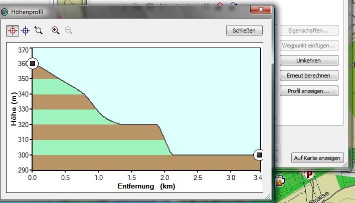
Hi, there seems to be a way to show elevation profiles for a route without having the DEM subfiles stored in the map. There is a byte in TDB file's header section which can be set to 1. If set MapSource generates the profile from the contour lines. The result is not as good as having the full information from DEM subfiles but better than nothing. Please try this patch, especially with maps without contour lines. Maybe setting this flag has to be bound to existing contour lines. Ronny

On 14.02.2010 23:53, Ronny Klier wrote:
Hi,
there seems to be a way to show elevation profiles for a route without having the DEM subfiles stored in the map. There is a byte in TDB file's header section which can be set to 1. If set MapSource generates the profile from the contour lines. The result is not as good as having the full information from DEM subfiles but better than nothing.
Please try this patch, especially with maps without contour lines. Maybe setting this flag has to be bound to existing contour lines.
Ronny
Is there any change to the .img themselves, or does this only affect the tdb??? (there is an option in gmaptool to enable fake profile, but it makes Mapsource crash sometimes when clicking on profile, was meant more for enabling maps to be seen in older basecamp versions). I will try to see how it affects when you have contourline only maps / vs simply including them by tdb/overview map tomorrow. Too late for today...
_______________________________________________ mkgmap-dev mailing list mkgmap-dev@lists.mkgmap.org.uk http://www.mkgmap.org.uk/mailman/listinfo/mkgmap-dev
Okay here are my results (actually the same as with gmaptool, I did not notice that "how" profile can be shown). 1.Only normal map without contourlines: Mapsource/Basecamp "show profile" is greyed out. 2. Only contourline map: Working in both: Mapsource 6.13.6, 6.15.11 as well as Basecamp 2.0.8 3. Mixed map made out of .img with osm mapt data and .img with contourlines (joined using: java -ea -jar -Xmx512M mkgmap.jar --index --description=%srtm% --route --country-abbr=%abr%_srtm --country-name="%date%_srtm" --mapname=%FID%0000 --family-id=%FID% --product-id=1 --series-name=%srtm% --family-name=%srtm% --tdbfile --overview-mapname=mapset --area-name=%country% 6*.img 7*.img :) Mapsource 6.13.6 on clicking on "show profile" empty profile comes up. Mapsource 6.15.11 clicking on "show profile": crash Basecamp: Clicking on elevation profile: Message "The current map does not contain any elevation data on the selected route". 4. Normal map including contourlines (contourlines as osm file merged with normal osm file using osmosis): Profile working in Mapsource/Basecamp. This is a lot of work and time. Also not legally possible with srtm data from viewfinderpanoramas.org. Is anyone able to get 3. working (without loosing autorouting)?? Does the patch have any effect on the .img (if so I would try to recompile my .img contourlines) Currently I need to seperate installs: Meaning both map as described and 2. and 3. I calculate my route on 3., then switch to contourline only map, and now clicking on show profile (only in Mapsoruce 6.15.11/Basecamp, not however in 6.13.x) a nice profile is shown. In Mapsource 6.13.6 I am not able at all to get a profile shown. (have not yet tried on GPS, but I think map as described under 3. would work for both autorouting and profile).

Turn restrictions do not seem to work with mp file input. Would this be difficult to add? Garvan

15.02.2010 15:07:01, Garvan & maew kirjoitti:
Turn restrictions do not seem to work with mp file input. Would this be difficult to add?
How would you represent turn restrictions in MP files? Does the MP format support relations? For what it is worth, multipolygons are implemented as relations too and thus should not work in the MP format. Marko
Marko Mäkelä wrote:
15.02.2010 15:07:01, Garvan & maew kirjoitti:
Turn restrictions do not seem to work with mp file input. Would this be difficult to add?
How would you represent turn restrictions in MP files? Does the MP format support relations? For what it is worth, multipolygons are implemented as relations too and thus should not work in the MP format.
Marko
Turn restrictions are implemented like this [Restrict] Nod=29298 TraffPoints=29431,29298,29431 TraffRoads=4791,4791 Time= [END-Restrict] [Restrict] Nod=29298 TraffPoints=29324,29298,29324 TraffRoads=4756,4756 Time= [END-Restrict] [Restrict] Nod=29298 TraffPoints=29303,29298,29303 TraffRoads=4756,4756 Time= [END-Restrict] This is a "No U-Turns" on all roads at a "T" junction as emitted by gpsmapedit. Nod=29298 is the actual point at the junction. I could make many more examples in gpsmapedit until I had a full understanding of the syntax. The mp file format supports the old definition of multipoligons where you have one outer and many inners, but the inner polygons must be in reverse direction (anti-clockwise) to show they are holes. Thus it covers all the basics as far a geometry is concerned, so tagging remains the only issue. Garvan

Turn restrictions are implemented like this
[Restrict] Nod=29298 TraffPoints=29431,29298,29431 TraffRoads=4791,4791 Time= [END-Restrict]
What I find interesting in this excerpt: It has a definition for time. I expect here the validity times for this restrictions. This would mean, that the garmin img format can handle this.

Hello Johann,
It has a definition for time. I expect here the validity times for this restrictions. This would mean, that the garmin img format can handle this.
Sure it can - Garmin turn restrictions can be a lot more complicated than we know how to encode. If you want to learn more about turn restriction encoding, take a look at the source for gpsmapedit. Mark
Hello Johann,
It has a definition for time. I expect here the validity times for this restrictions. This would mean, that the garmin img format can handle this.
Sure it can - Garmin turn restrictions can be a lot more complicated than we know how to encode.
If you want to learn more about turn restriction encoding, take a look at the source for gpsmapedit.
Mark
Thats interesting. I thought always gpsmapedit relays on cGPSmapper to parse the garmin img format. I personally dont use this tool, (no windows available) so I dont know it. Also I'm astonished, that there is source code available. Reading the license site it says: 2.2 Reverse Engineering. You may not modify, reverse engineer, decompile, disassemble (except to the extent applicable laws specifically prohibit such restrictions) or create derivative works based on the Software, or any portion thereof. But on the other hand: 2.8 Source Code. You may evaluate the Source Code freely while the right to use and modify the Source Code for development of own products is granted only if (a) the registration fee for the Software is paid; (b) it is prohibited to remove original copyright notes in the source files; (c) you may use Source Code in own programs, provided that the copyright notes of the programs should include the reference to the Author (portions "Konstantin Galichsky, kg@geopainting.com") and to the Software Web page ("http://www.geopainting.com").
2.2 Reverse Engineering.
You may not modify, reverse engineer, decompile, disassemble (except to the extent applicable laws specifically prohibit such restrictions) or create derivative works based on the Software, or any portion thereof.
But on the other hand:
2.8 Source Code.
You may evaluate the Source Code freely while the right to use and modify the Source Code for development of own products is granted only if (a) the registration fee for the Software is paid; (b) it is prohibited to remove original copyright notes in the source files; (c) you may use Source Code in own programs, provided that the copyright notes of the programs should include the reference to the Author (portions "Konstantin Galichsky, kg@geopainting.com") and to the Software Web page ("http://www.geopainting.com").
Well a large part of gpsmapedit is not open sourced, therefore 2.2 and 2.8 differences. That's at least how I understand it.
_______________________________________________ mkgmap-dev mailing list mkgmap-dev@lists.mkgmap.org.uk http://www.mkgmap.org.uk/mailman/listinfo/mkgmap-dev
Apologizes for the wrong subject in my last post, I will try again. Turn restrictions do not seem to work with mp file input. Would this be difficult to add? Garvan Garvan & maew wrote:
Turn restrictions do not seem to work with mp file input. Would this be difficult to add?
Garvan
_______________________________________________ mkgmap-dev mailing list mkgmap-dev@lists.mkgmap.org.uk http://www.mkgmap.org.uk/mailman/listinfo/mkgmap-dev
Hello Garvan,
Turn restrictions do not seem to work with mp file input. Would this be difficult to add?
I am not familiar with the way the turn restrictions are specified in MP files but I doubt if it is difficult to add support for them. Personally, I would prefer to spend my (limited) time working on OSM related features or making the core functionality better so I am not keen to work on that. Cheers, Mark
Mark Burton wrote:
Hello Garvan,
Turn restrictions do not seem to work with mp file input. Would this be difficult to add?
I am not familiar with the way the turn restrictions are specified in MP files but I doubt if it is difficult to add support for them.
Personally, I would prefer to spend my (limited) time working on OSM related features or making the core functionality better so I am not keen to work on that.
Cheers,
I understand that everybody must set their own priorities on how they use their available free time. I hope there might be others that could help with keeping the mp input up-to-date. Garvan
Am 15.02.2010 12:02, schrieb Felix Hartmann:
Okay here are my results (actually the same as with gmaptool, I did not notice that "how" profile can be shown).
1.Only normal map without contourlines: Mapsource/Basecamp "show profile" is greyed out.
2. Only contourline map: Working in both: Mapsource 6.13.6, 6.15.11 as well as Basecamp 2.0.8
3. Mixed map made out of .img with osm mapt data and .img with contourlines (joined using: java -ea -jar -Xmx512M mkgmap.jar --index --description=%srtm% --route --country-abbr=%abr%_srtm --country-name="%date%_srtm" --mapname=%FID%0000 --family-id=%FID% --product-id=1 --series-name=%srtm% --family-name=%srtm% --tdbfile --overview-mapname=mapset --area-name=%country% 6*.img 7*.img :) Mapsource 6.13.6 on clicking on "show profile" empty profile comes up. Mapsource 6.15.11 clicking on "show profile": crash Basecamp: Clicking on elevation profile: Message "The current map does not contain any elevation data on the selected route".
4. Normal map including contourlines (contourlines as osm file merged with normal osm file using osmosis): Profile working in Mapsource/Basecamp. This is a lot of work and time. Also not legally possible with srtm data from viewfinderpanoramas.org.
Is anyone able to get 3. working (without loosing autorouting)?? Does the patch have any effect on the .img (if so I would try to recompile my .img contourlines) Currently I need to seperate installs: Meaning both map as described and 2. and 3. I calculate my route on 3., then switch to contourline only map, and now clicking on show profile (only in Mapsoruce 6.15.11/Basecamp, not however in 6.13.x) a nice profile is shown. In Mapsource 6.13.6 I am not able at all to get a profile shown. (have not yet tried on GPS, but I think map as described under 3. would work for both autorouting and profile).
There is no change to the img files. I tryed scenario 3. and got the same problems. I think MapSource gets confused having two img's for the same area. Knowing this scenaro its required to have an option to turn it off. Until now I created my maps as described in 4. But using a fix areas.list from splitter so I had not to rebuild contour lines osm again and again. Actually I am working on the integrated contour line feature of mkgmap. It failed if a map didn't fit in a single DEM data file (SRTM, CGIAR or ASTER). For SRTM data I am now able to cover larger areas. The time went up from around 1.5 hours for my germany generation to 2 hours not counting the time previously required to generate and merge elevation osm with srtm2osm and osmosis. So this approach seems to be not slower and saves disk space.
On 15.02.2010 21:30, Ronny Klier wrote:
Am 15.02.2010 12:02, schrieb Felix Hartmann:
Okay here are my results (actually the same as with gmaptool, I did not notice that "how" profile can be shown).
1.Only normal map without contourlines: Mapsource/Basecamp "show profile" is greyed out.
2. Only contourline map: Working in both: Mapsource 6.13.6, 6.15.11 as well as Basecamp 2.0.8
3. Mixed map made out of .img with osm mapt data and .img with contourlines (joined using: java -ea -jar -Xmx512M mkgmap.jar --index --description=%srtm% --route --country-abbr=%abr%_srtm --country-name="%date%_srtm" --mapname=%FID%0000 --family-id=%FID% --product-id=1 --series-name=%srtm% --family-name=%srtm% --tdbfile --overview-mapname=mapset --area-name=%country% 6*.img 7*.img :) Mapsource 6.13.6 on clicking on "show profile" empty profile comes up. Mapsource 6.15.11 clicking on "show profile": crash Basecamp: Clicking on elevation profile: Message "The current map does not contain any elevation data on the selected route".
4. Normal map including contourlines (contourlines as osm file merged with normal osm file using osmosis): Profile working in Mapsource/Basecamp. This is a lot of work and time. Also not legally possible with srtm data from viewfinderpanoramas.org.
Is anyone able to get 3. working (without loosing autorouting)?? Does the patch have any effect on the .img (if so I would try to recompile my .img contourlines) Currently I need to seperate installs: Meaning both map as described and 2. and 3. I calculate my route on 3., then switch to contourline only map, and now clicking on show profile (only in Mapsoruce 6.15.11/Basecamp, not however in 6.13.x) a nice profile is shown. In Mapsource 6.13.6 I am not able at all to get a profile shown. (have not yet tried on GPS, but I think map as described under 3. would work for both autorouting and profile).
There is no change to the img files.
I tryed scenario 3. and got the same problems. I think MapSource gets confused having two img's for the same area. Knowing this scenaro its required to have an option to turn it off.
Until now I created my maps as described in 4. But using a fix areas.list from splitter so I had not to rebuild contour lines osm again and again.
Actually I am working on the integrated contour line feature of mkgmap. It failed if a map didn't fit in a single DEM data file (SRTM, CGIAR or ASTER). For SRTM data I am now able to cover larger areas. The time went up from around 1.5 hours for my germany generation to 2 hours not counting the time previously required to generate and merge elevation osm with srtm2osm and osmosis. So this approach seems to be not slower and saves disk space.
Well if it were possible the best way to use it would be.... If mkgmap could do the merging. Of course it is clear that one has to cut down on the max-nodes a bit more, but except the Alps excerpt from Geofabrik, all regions are pretty easy. There would be several ways that I would think of as very successful: a) mkgmap accepts osm AND .img as input, and simply takes the contourlines from the .img and adds them to the tiles after the normal osm data has been written. This would of course require support for reading in .img files (but I think it should not be to much work to implement if one limits this to plain lines without routing, indexes and so on read in. b) Compiling to img from mp for Contourlines my PC needs 8 minutes for all of Europe (Germany is 35seconds). So for a) simply exchange .img input by mp input. c) make mkgmap combine .img files. That would be the nicest solution. d) make mkgmap able to write out 2 osm files into one single .img. That should be the easiest solution. Above scenario 3 has the added problem that sometimes the contourlines do show up in Mapsource, sometimes not. Reopening/Closing Mapsource changes the situation. I don't know how to get contourline .img shown permanently on top of the other maps (simply using higher ID does NOT work, even more strange if I feed mkgmap with java mkgmap.jar .... 6*.img 7*.img with 7*.img being the contourlines it sometimes works, If I change the command around to java mkgmap.jar .... 7*.img 6*.img the contourlines are never on top in Mapsource; the only thing that seems to work always is to run java mkgmap .jar ..... *.osm *.mp)
_______________________________________________ mkgmap-dev mailing list mkgmap-dev@lists.mkgmap.org.uk http://www.mkgmap.org.uk/mailman/listinfo/mkgmap-dev
Am 15.02.2010 22:13, schrieb Felix Hartmann:
On 15.02.2010 21:30, Ronny Klier wrote:
Am 15.02.2010 12:02, schrieb Felix Hartmann:
Okay here are my results (actually the same as with gmaptool, I did not notice that "how" profile can be shown).
1.Only normal map without contourlines: Mapsource/Basecamp "show profile" is greyed out.
2. Only contourline map: Working in both: Mapsource 6.13.6, 6.15.11 as well as Basecamp 2.0.8
3. Mixed map made out of .img with osm mapt data and .img with contourlines (joined using: java -ea -jar -Xmx512M mkgmap.jar --index --description=%srtm% --route --country-abbr=%abr%_srtm --country-name="%date%_srtm" --mapname=%FID%0000 --family-id=%FID% --product-id=1 --series-name=%srtm% --family-name=%srtm% --tdbfile --overview-mapname=mapset --area-name=%country% 6*.img 7*.img :) Mapsource 6.13.6 on clicking on "show profile" empty profile comes up. Mapsource 6.15.11 clicking on "show profile": crash Basecamp: Clicking on elevation profile: Message "The current map does not contain any elevation data on the selected route".
4. Normal map including contourlines (contourlines as osm file merged with normal osm file using osmosis): Profile working in Mapsource/Basecamp. This is a lot of work and time. Also not legally possible with srtm data from viewfinderpanoramas.org.
Is anyone able to get 3. working (without loosing autorouting)?? Does the patch have any effect on the .img (if so I would try to recompile my .img contourlines) Currently I need to seperate installs: Meaning both map as described and 2. and 3. I calculate my route on 3., then switch to contourline only map, and now clicking on show profile (only in Mapsoruce 6.15.11/Basecamp, not however in 6.13.x) a nice profile is shown. In Mapsource 6.13.6 I am not able at all to get a profile shown. (have not yet tried on GPS, but I think map as described under 3. would work for both autorouting and profile).
There is no change to the img files.
I tryed scenario 3. and got the same problems. I think MapSource gets confused having two img's for the same area. Knowing this scenaro its required to have an option to turn it off.
Until now I created my maps as described in 4. But using a fix areas.list from splitter so I had not to rebuild contour lines osm again and again.
Actually I am working on the integrated contour line feature of mkgmap. It failed if a map didn't fit in a single DEM data file (SRTM, CGIAR or ASTER). For SRTM data I am now able to cover larger areas. The time went up from around 1.5 hours for my germany generation to 2 hours not counting the time previously required to generate and merge elevation osm with srtm2osm and osmosis. So this approach seems to be not slower and saves disk space.
Well if it were possible the best way to use it would be....
If mkgmap could do the merging. Of course it is clear that one has to cut down on the max-nodes a bit more, but except the Alps excerpt from Geofabrik, all regions are pretty easy.
There would be several ways that I would think of as very successful: a) mkgmap accepts osm AND .img as input, and simply takes the contourlines from the .img and adds them to the tiles after the normal osm data has been written. This would of course require support for reading in .img files (but I think it should not be to much work to implement if one limits this to plain lines without routing, indexes and so on read in. b) Compiling to img from mp for Contourlines my PC needs 8 minutes for all of Europe (Germany is 35seconds). So for a) simply exchange .img input by mp input. c) make mkgmap combine .img files. That would be the nicest solution. d) make mkgmap able to write out 2 osm files into one single .img. That should be the easiest solution.
Above scenario 3 has the added problem that sometimes the contourlines do show up in Mapsource, sometimes not. Reopening/Closing Mapsource changes the situation. I don't know how to get contourline .img shown permanently on top of the other maps (simply using higher ID does NOT work, even more strange if I feed mkgmap with java mkgmap.jar .... 6*.img 7*.img with 7*.img being the contourlines it sometimes works, If I change the command around to java mkgmap.jar .... 7*.img 6*.img the contourlines are never on top in Mapsource; the only thing that seems to work always is to run java mkgmap .jar ..... *.osm *.mp)
_______________________________________________ mkgmap-dev mailing list mkgmap-dev@lists.mkgmap.org.uk http://www.mkgmap.org.uk/mailman/listinfo/mkgmap-dev
These ways would be great still they are not related to what the contour lines part of mkgmap does ;-) I am with you: d) should be the simplest to implement (Not knowing whats really neccessary for this to work). I think everything which involves reading img files is a lot harder because the file structure seems not to be straight forward readable.
participants (6)
-
 Felix Hartmann
 -
 Garvan & maew
 -
 Johann Gail
 -
 Mark Burton
 -
 Marko Mäkelä
 -
 Ronny Klier