Need some information about routing

Hi all I've stumbeled about a small routing problem. I do create two types of maps, one is called "myland" with nearly all informations to be found in OSM, the other is called "mystreet" which do mainly show all streets but less information about the surrounding. The two 'lines' files in the appropriate styles are nearly same, except that for the street map all the ways not suitable for automotive driving are not rendered. My question is, using the same destination in either map, the routing is slightly different in my Garmin 276Cx. For example, routing in the land map uses some grade1 tracks within a forest, the street map does not. But the tracks are to be find in both maps. Anyone an idea, why this is computed differently in the device ? See also attached pictures -- Mit freundlichen Grüßen ##################################################### Manfred Haiduk, Zum Fischbach 9, 52393 Hürtgenwald e-mail mhaiduk@t-online.de #####################################################

Hi Manfred, If you created the two maps from exactly the same input files and with the same options reg. routing I assume that this is caused by the differences in the two lines files. Can't say more without knowing the exact input data and options for mkgmap. Gerd ________________________________________ Von: mkgmap-dev <mkgmap-dev-bounces@lists.mkgmap.org.uk> im Auftrag von Manfred Haiduk <mhaiduk@t-online.de> Gesendet: Dienstag, 3. Juli 2018 16:35:21 An: mkgmap-dev@lists.mkgmap.org.uk Betreff: [mkgmap-dev] Need some information about routing Hi all I've stumbeled about a small routing problem. I do create two types of maps, one is called "myland" with nearly all informations to be found in OSM, the other is called "mystreet" which do mainly show all streets but less information about the surrounding. The two 'lines' files in the appropriate styles are nearly same, except that for the street map all the ways not suitable for automotive driving are not rendered. My question is, using the same destination in either map, the routing is slightly different in my Garmin 276Cx. For example, routing in the land map uses some grade1 tracks within a forest, the street map does not. But the tracks are to be find in both maps. Anyone an idea, why this is computed differently in the device ? See also attached pictures -- Mit freundlichen Grüßen ##################################################### Manfred Haiduk, Zum Fischbach 9, 52393 Hürtgenwald e-mail mhaiduk@t-online.de #####################################################

Could the extra routing nodes cause a time penalty in the routing algorithm, in a similar way that 'sharp-angle-fixer' attempts to deal with? Ticker On Sat, 2018-07-07 at 08:01 +0000, Gerd Petermann wrote:
Hi Manfred,
If you created the two maps from exactly the same input files and with the same options reg. routing I assume that this is caused by the differences in the two lines files. Can't say more without knowing the exact input data and options for mkgmap.
Gerd
________________________________________ Von: mkgmap-dev <mkgmap-dev-bounces@lists.mkgmap.org.uk> im Auftrag von Manfred Haiduk <mhaiduk@t-online.de> Gesendet: Dienstag, 3. Juli 2018 16:35:21 An: mkgmap-dev@lists.mkgmap.org.uk Betreff: [mkgmap-dev] Need some information about routing
Hi all
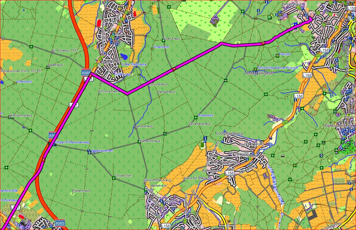
I've stumbeled about a small routing problem. I do create two types of maps, one is called "myland" with nearly all informations to be found in OSM, the other is called "mystreet" which do mainly show all streets but less information about the surrounding. The two 'lines' files in the appropriate styles are nearly same, except that for the street map all the ways not suitable for automotive driving are not rendered.
My question is, using the same destination in either map, the routing is slightly different in my Garmin 276Cx. For example, routing in the land map uses some grade1 tracks within a forest, the street map does not. But the tracks are to be find in both maps. Anyone an idea, why this is computed differently in the device ?
See also attached pictures
--
Mit freundlichen Grüßen
##################################################### Manfred Haiduk, Zum Fischbach 9, 52393 Hürtgenwald e-mail mhaiduk@t-online.de #####################################################
_______________________________________________ mkgmap-dev mailing list mkgmap-dev@lists.mkgmap.org.uk http://www.mkgmap.org.uk/mailman/listinfo/mkgmap-dev
Either this or the extra nodes simply cause the routing algo to stop looking at a possible route. I think the algo prefers a route with fewer nodes. Gerd ________________________________________ Von: mkgmap-dev <mkgmap-dev-bounces@lists.mkgmap.org.uk> im Auftrag von Ticker Berkin <rwb-mkgmap@jagit.co.uk> Gesendet: Samstag, 7. Juli 2018 12:05:11 An: mkgmap-dev@lists.mkgmap.org.uk Betreff: Re: [mkgmap-dev] Need some information about routing Could the extra routing nodes cause a time penalty in the routing algorithm, in a similar way that 'sharp-angle-fixer' attempts to deal with? Ticker On Sat, 2018-07-07 at 08:01 +0000, Gerd Petermann wrote:
Hi Manfred,
If you created the two maps from exactly the same input files and with the same options reg. routing I assume that this is caused by the differences in the two lines files. Can't say more without knowing the exact input data and options for mkgmap.
Gerd
________________________________________ Von: mkgmap-dev <mkgmap-dev-bounces@lists.mkgmap.org.uk> im Auftrag von Manfred Haiduk <mhaiduk@t-online.de> Gesendet: Dienstag, 3. Juli 2018 16:35:21 An: mkgmap-dev@lists.mkgmap.org.uk Betreff: [mkgmap-dev] Need some information about routing
Hi all
I've stumbeled about a small routing problem. I do create two types of maps, one is called "myland" with nearly all informations to be found in OSM, the other is called "mystreet" which do mainly show all streets but less information about the surrounding. The two 'lines' files in the appropriate styles are nearly same, except that for the street map all the ways not suitable for automotive driving are not rendered.
My question is, using the same destination in either map, the routing is slightly different in my Garmin 276Cx. For example, routing in the land map uses some grade1 tracks within a forest, the street map does not. But the tracks are to be find in both maps. Anyone an idea, why this is computed differently in the device ?
See also attached pictures
--
Mit freundlichen Grüßen
##################################################### Manfred Haiduk, Zum Fischbach 9, 52393 Hürtgenwald e-mail mhaiduk@t-online.de #####################################################
_______________________________________________ mkgmap-dev mailing list mkgmap-dev@lists.mkgmap.org.uk http://www.mkgmap.org.uk/mailman/listinfo/mkgmap-dev
mkgmap-dev mailing list mkgmap-dev@lists.mkgmap.org.uk http://www.mkgmap.org.uk/mailman/listinfo/mkgmap-dev
Hi Gerd thanks for the first answer. I will do some more tests, especially really using the exact same input data for building land and street map. Up to now, i thought, i used the same, but in my device i have had maps of whole europe and for testing only nordrhein westfalen. So the observation might not be complete correct. Am 07.07.2018 um 10:01 schrieb Gerd Petermann:
Hi Manfred,
If you created the two maps from exactly the same input files and with the same options reg. routing I assume that this is caused by the differences in the two lines files. Can't say more without knowing the exact input data and options for mkgmap.
Gerd
________________________________________ Von: mkgmap-dev <mkgmap-dev-bounces@lists.mkgmap.org.uk> im Auftrag von Manfred Haiduk <mhaiduk@t-online.de> Gesendet: Dienstag, 3. Juli 2018 16:35:21 An: mkgmap-dev@lists.mkgmap.org.uk Betreff: [mkgmap-dev] Need some information about routing
Hi all
I've stumbeled about a small routing problem. I do create two types of maps, one is called "myland" with nearly all informations to be found in OSM, the other is called "mystreet" which do mainly show all streets but less information about the surrounding. The two 'lines' files in the appropriate styles are nearly same, except that for the street map all the ways not suitable for automotive driving are not rendered.
My question is, using the same destination in either map, the routing is slightly different in my Garmin 276Cx. For example, routing in the land map uses some grade1 tracks within a forest, the street map does not. But the tracks are to be find in both maps. Anyone an idea, why this is computed differently in the device ?
See also attached pictures
--
Mit freundlichen Grüßen
##################################################### Manfred Haiduk, Zum Fischbach 9, 52393 Hürtgenwald e-mail mhaiduk@t-online.de #####################################################
_______________________________________________ mkgmap-dev mailing list mkgmap-dev@lists.mkgmap.org.uk http://www.mkgmap.org.uk/mailman/listinfo/mkgmap-dev
-- Mit freundlichen Grüßen ##################################################### Manfred Haiduk, Zum Fischbach 9, 52393 Hürtgenwald e-mail mhaiduk@t-online.de #####################################################
participants (3)
-
 Gerd Petermann
 -
 Manfred Haiduk
 -
 Ticker Berkin