The "Elevation=M" in the header of the polish .MP files does not work

Good afternoon ! I am using the latest version of MkGMap and trying to create a depth chart with isolines (types 0x24, 0x25). The problem is that the compiler interprets the depth specified in Meters as in Feet. The result is independent of the presence or value of the "Elevation=M" parameter. And I didn't find an alternative command line option. :( So how can I tell the compiler to treat all numerical depth and height values in an .MP file as meters and not feet? Thanks for the advice. PS: cGpsMapper works fine with "Elevation=M" of course. PPS: Example of polylyne defs: [POLYLINE] Type=0x02500 Label=21 EndLevel=3 Data0=(47.139263517000003,-122.560520313), ... [END] [POLYLINE] Type=0x02500 Label=12 EndLevel=3 Data0=(47.127846400000003,-122.562501059), ... [END] -- Vadim Karpov

Hi Vadim, I see code in mkgmap to handle the statement with Elevation=m or Elevation=M, but it is only used for the line types 0x20 .. 0x22. Do you have a good reason to use line type 0x25 instead? Gerd ________________________________________ Von: mkgmap-dev <mkgmap-dev-bounces@lists.mkgmap.org.uk> im Auftrag von Vadim Karpov <bombur@mail.ru> Gesendet: Mittwoch, 1. März 2023 13:00 An: mkgmap-dev@lists.mkgmap.org.uk Betreff: [mkgmap-dev] The "Elevation=M" in the header of the polish .MP files does not work Good afternoon ! I am using the latest version of MkGMap and trying to create a depth chart with isolines (types 0x24, 0x25). The problem is that the compiler interprets the depth specified in Meters as in Feet. The result is independent of the presence or value of the "Elevation=M" parameter. And I didn't find an alternative command line option. :( So how can I tell the compiler to treat all numerical depth and height values in an .MP file as meters and not feet? Thanks for the advice. PS: cGpsMapper works fine with "Elevation=M" of course. PPS: Example of polylyne defs: [POLYLINE] Type=0x02500 Label=21 EndLevel=3 Data0=(47.139263517000003,-122.560520313), ... [END] [POLYLINE] Type=0x02500 Label=12 EndLevel=3 Data0=(47.127846400000003,-122.562501059), ... [END] -- Vadim Karpov

Hi My understanding of the default Garmin usage is that 0x20..0x22 are land/height contours (Minor to Major) 0x23..0x25 are sea/depth " " Ticker On Thu, 2023-03-02 at 08:52 +0000, Gerd Petermann wrote:
Hi Vadim,
I see code in mkgmap to handle the statement with Elevation=m or Elevation=M, but it is only used for the line types 0x20 .. 0x22. Do you have a good reason to use line type 0x25 instead?
Gerd
________________________________________ Von: mkgmap-dev <mkgmap-dev-bounces@lists.mkgmap.org.uk> im Auftrag von Vadim Karpov <bombur@mail.ru> Gesendet: Mittwoch, 1. März 2023 13:00 An: mkgmap-dev@lists.mkgmap.org.uk Betreff: [mkgmap-dev] The "Elevation=M" in the header of the polish .MP files does not work
Good afternoon !
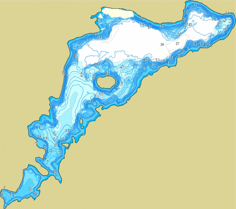
I am using the latest version of MkGMap and trying to create a depth chart with isolines (types 0x24, 0x25).
The problem is that the compiler interprets the depth specified in Meters as in Feet. The result is independent of the presence or value of the "Elevation=M" parameter.
And I didn't find an alternative command line option. :(
So how can I tell the compiler to treat all numerical depth and height values in an .MP file as meters and not feet?
Thanks for the advice.
PS: cGpsMapper works fine with "Elevation=M" of course. PPS: Example of polylyne defs:
[POLYLINE] Type=0x02500 Label=21 EndLevel=3 Data0=(47.139263517000003,-122.560520313), ... [END]
[POLYLINE] Type=0x02500 Label=12 EndLevel=3 Data0=(47.127846400000003,-122.562501059), ... [END]
-- Vadim Karpov _______________________________________________ mkgmap-dev mailing list mkgmap-dev@lists.mkgmap.org.uk https://www.mkgmap.org.uk/mailman/listinfo/mkgmap-dev
Hi Yes. Types 0x23.0x24.0x25 are used to create bathymetric maps. Information from the MPCTypes.txt file ( TypViewer application): 0x02000=Contour Lines/MINOR_CONTOUR/Minor land-based contour line/Non NT 0x02100=Contour Lines/INT_CONTOUR/Intermediate contour (should be used for about every 5th contour line)/Non NT 0x02200=Contour Lines/MAJOR_CONTOUR/Major contour (should be used for about every 10th contour line)/Non NT 0x02300=Contour Lines/MINOR_BATHY_CONTOUR/Minor bathymetric, or depth, contour/Non NT 0x02400=Contour Lines/INT_BATHY_CONTOUR/Intermediate bathymetric, or depth, contour (should be used for about every 5th contour line)/Non NT 0x02500=Contour Lines/MAJOR_BATHY_CONTOUR/Major bathymetric, or depth, contour (should be used for about every 10th contour line)/Non NT
Четверг, 2 марта 2023, 12:01 +03:00 от Ticker Berkin <rwb-mkgmap@jagit.co.uk>: Hi
My understanding of the default Garmin usage is that 0x20..0x22 are land/height contours (Minor to Major) 0x23..0x25 are sea/depth " "
Ticker On Thu, 2023-03-02 at 08:52 +0000, Gerd Petermann wrote:
Hi Vadim,
I see code in mkgmap to handle the statement with Elevation=m or Elevation=M, but it is only used for the line types 0x20 .. 0x22. Do you have a good reason to use line type 0x25 instead?
Gerd
________________________________________ Von: mkgmap-dev < mkgmap-dev-bounces@lists.mkgmap.org.uk > im Auftrag von Vadim Karpov < bombur@mail.ru > Gesendet: Mittwoch, 1. März 2023 13:00 An: mkgmap-dev@lists.mkgmap.org.uk Betreff: [mkgmap-dev] The "Elevation=M" in the header of the polish .MP files does not work
Good afternoon !
I am using the latest version of MkGMap and trying to create a depth chart with isolines (types 0x24, 0x25).
The problem is that the compiler interprets the depth specified in Meters as in Feet. The result is independent of the presence or value of the "Elevation=M" parameter.
And I didn't find an alternative command line option. :(
So how can I tell the compiler to treat all numerical depth and height values in an .MP file as meters and not feet?
Thanks for the advice.
PS: cGpsMapper works fine with "Elevation=M" of course. PPS: Example of polylyne defs:
[POLYLINE] Type=0x02500 Label=21 EndLevel=3 Data0=(47.139263517000003,-122.560520313), ... [END]
[POLYLINE] Type=0x02500 Label=12 EndLevel=3 Data0=(47.127846400000003,-122.562501059), ... [END]
-- Vadim Karpov _______________________________________________ mkgmap-dev mailing list mkgmap-dev@lists.mkgmap.org.uk https://www.mkgmap.org.uk/mailman/listinfo/mkgmap-dev -- Vadim Karpov Отправлено из Почты Mail.ru
Hi all, OK, I see no problems to change this method in GType.java: public static boolean isContourLine(MapLine line) { return line.getType() >= 0x20 && line.getType() <= 0x22 && !(line instanceof MapShape); } All I have to do is to change 0x22 to 0x25, right? Gerd ________________________________________ Von: mkgmap-dev <mkgmap-dev-bounces@lists.mkgmap.org.uk> im Auftrag von Vadim Karpov <bombur@mail.ru> Gesendet: Donnerstag, 2. März 2023 14:38 An: mkgmap-dev@lists.mkgmap.org.uk Betreff: Re: [mkgmap-dev] The "Elevation=M" in the header of the polish .MP files does not work Hi Yes. Types 0x23.0x24.0x25 are used to create bathymetric maps. Information from the MPCTypes.txt file (TypViewer application): 0x02000=Contour Lines/MINOR_CONTOUR/Minor land-based contour line/Non NT 0x02100=Contour Lines/INT_CONTOUR/Intermediate contour (should be used for about every 5th contour line)/Non NT 0x02200=Contour Lines/MAJOR_CONTOUR/Major contour (should be used for about every 10th contour line)/Non NT 0x02300=Contour Lines/MINOR_BATHY_CONTOUR/Minor bathymetric, or depth, contour/Non NT 0x02400=Contour Lines/INT_BATHY_CONTOUR/Intermediate bathymetric, or depth, contour (should be used for about every 5th contour line)/Non NT 0x02500=Contour Lines/MAJOR_BATHY_CONTOUR/Major bathymetric, or depth, contour (should be used for about every 10th contour line)/Non NT Четверг, 2 марта 2023, 12:01 +03:00 от Ticker Berkin <rwb-mkgmap@jagit.co.uk>: Hi My understanding of the default Garmin usage is that 0x20..0x22 are land/height contours (Minor to Major) 0x23..0x25 are sea/depth " " Ticker On Thu, 2023-03-02 at 08:52 +0000, Gerd Petermann wrote:
Hi Vadim,
I see code in mkgmap to handle the statement with Elevation=m or Elevation=M, but it is only used for the line types 0x20 .. 0x22. Do you have a good reason to use line type 0x25 instead?
Gerd
________________________________________ Von: mkgmap-dev <mkgmap-dev-bounces@lists.mkgmap.org.uk</compose?To=mkgmap%2ddev%2dbounces@lists.mkgmap.org.uk>> im Auftrag von Vadim Karpov <bombur@mail.ru</compose?To=bombur@mail.ru>> Gesendet: Mittwoch, 1. März 2023 13:00 An: mkgmap-dev@lists.mkgmap.org.uk</compose?To=mkgmap%2ddev@lists.mkgmap.org.uk> Betreff: [mkgmap-dev] The "Elevation=M" in the header of the polish .MP files does not work
Good afternoon !
I am using the latest version of MkGMap and trying to create a depth chart with isolines (types 0x24, 0x25).
The problem is that the compiler interprets the depth specified in Meters as in Feet. The result is independent of the presence or value of the "Elevation=M" parameter.
And I didn't find an alternative command line option. :(
So how can I tell the compiler to treat all numerical depth and height values in an .MP file as meters and not feet?
Thanks for the advice.
PS: cGpsMapper works fine with "Elevation=M" of course. PPS: Example of polylyne defs:
[POLYLINE] Type=0x02500 Label=21 EndLevel=3 Data0=(47.139263517000003,-122.560520313), ... [END]
[POLYLINE] Type=0x02500 Label=12 EndLevel=3 Data0=(47.127846400000003,-122.562501059), ... [END]
-- Vadim Karpov _______________________________________________ mkgmap-dev mailing list mkgmap-dev@lists.mkgmap.org.uk</compose?To=mkgmap%2ddev@lists.mkgmap.org.uk> https://www.mkgmap.org.uk/mailman/listinfo/mkgmap-dev
-- Vadim Karpov Отправлено из Почты Mail.ru<https://trk.mail.ru/c/zzm979>
Hi Gerd Change looks good. I've forgotten why contours have different RoundCoordsFilter but these line-types will now be included in this behaviour. Ticker On Thu, 2023-03-02 at 15:01 +0000, Gerd Petermann wrote:
Hi all,
OK, I see no problems to change this method in GType.java: public static boolean isContourLine(MapLine line) { return line.getType() >= 0x20 && line.getType() <= 0x22 && !(line instanceof MapShape); }
All I have to do is to change 0x22 to 0x25, right?
Gerd
________________________________________ Von: mkgmap-dev <mkgmap-dev-bounces@lists.mkgmap.org.uk> im Auftrag von Vadim Karpov <bombur@mail.ru> Gesendet: Donnerstag, 2. März 2023 14:38 An: mkgmap-dev@lists.mkgmap.org.uk Betreff: Re: [mkgmap-dev] The "Elevation=M" in the header of the polish .MP files does not work
Hi
Yes.
Types 0x23.0x24.0x25 are used to create bathymetric maps.
Information from the MPCTypes.txt file (TypViewer application):
0x02000=Contour Lines/MINOR_CONTOUR/Minor land-based contour line/Non NT 0x02100=Contour Lines/INT_CONTOUR/Intermediate contour (should be used for about every 5th contour line)/Non NT 0x02200=Contour Lines/MAJOR_CONTOUR/Major contour (should be used for about every 10th contour line)/Non NT
0x02300=Contour Lines/MINOR_BATHY_CONTOUR/Minor bathymetric, or depth, contour/Non NT 0x02400=Contour Lines/INT_BATHY_CONTOUR/Intermediate bathymetric, or depth, contour (should be used for about every 5th contour line)/Non NT 0x02500=Contour Lines/MAJOR_BATHY_CONTOUR/Major bathymetric, or depth, contour (should be used for about every 10th contour line)/Non NT
Четверг, 2 марта 2023, 12:01 +03:00 от Ticker Berkin <rwb-mkgmap@jagit.co.uk>:
Hi
My understanding of the default Garmin usage is that 0x20..0x22 are land/height contours (Minor to Major) 0x23..0x25 are sea/depth " "
Ticker
On Thu, 2023-03-02 at 08:52 +0000, Gerd Petermann wrote:
Hi Vadim,
I see code in mkgmap to handle the statement with Elevation=m or Elevation=M, but it is only used for the line types 0x20 .. 0x22. Do you have a good reason to use line type 0x25 instead?
Gerd
________________________________________ Von: mkgmap-dev <mkgmap-dev-bounces@lists.mkgmap.org.uk</compose?To=mkgmap%2ddev%2d bounces@lists.mkgmap.org.uk>> im Auftrag von Vadim Karpov <bombur@mail.ru</compose?To=bombur@mail.ru>> Gesendet: Mittwoch, 1. März 2023 13:00 An: mkgmap-dev@lists.mkgmap.org.uk</compose?To=mkgmap%2ddev@lists.mkgmap.org.uk
Betreff: [mkgmap-dev] The "Elevation=M" in the header of the polish .MP files does not work
Good afternoon !
I am using the latest version of MkGMap and trying to create a depth chart with isolines (types 0x24, 0x25).
The problem is that the compiler interprets the depth specified in Meters as in Feet. The result is independent of the presence or value of the "Elevation=M" parameter.
And I didn't find an alternative command line option. :(
So how can I tell the compiler to treat all numerical depth and height values in an .MP file as meters and not feet?
Thanks for the advice.
PS: cGpsMapper works fine with "Elevation=M" of course. PPS: Example of polylyne defs:
[POLYLINE] Type=0x02500 Label=21 EndLevel=3 Data0=(47.139263517000003,-122.560520313), ... [END]
[POLYLINE] Type=0x02500 Label=12 EndLevel=3 Data0=(47.127846400000003,-122.562501059), ... [END]
-- Vadim Karpov _______________________________________________ mkgmap-dev mailing list mkgmap-dev@lists.mkgmap.org.uk< /compose?To=mkgmap%2ddev@lists.mkgmap.org.uk> https://www.mkgmap.org.uk/mailman/listinfo/mkgmap-dev
-- Vadim Karpov Отправлено из Почты Mail.ru<https://trk.mail.ru/c/zzm979>
_______________________________________________ mkgmap-dev mailing list mkgmap-dev@lists.mkgmap.org.uk https://www.mkgmap.org.uk/mailman/listinfo/mkgmap-dev
Hi I did a search for the word " CONTOUR " in the file MPCTypes.txt . In addition to the types mentioned above, there are several more: 0x10105 =Marine Lines/MARINE_CONTOUR_LINE/Marine contour line/Non NT, NT 0x10301 =Isobath Area Outlines/ISOBATH_DEPTH_CONTOUR/Depth contour/Non NT, NT 0x10900 =Contour Lines/MINOR_CONTOUR(NT)/Minor land-based contour line/NT 0x10901 =Contour Lines/INT_CONTOUR(NT)/Intermediate contour (should be used for about every 5th contour line)/NT 0x10902 =Contour Lines/MAJOR_CONTOUR(NT)/Major contour (should be used for about every 10th contour line)/NT 0x10903 =Contour Lines/MINOR_BATHY_CONTOUR(NT)/Minor bathymetric, or depth, contour/NT 0x10904 =Contour Lines/INT_BATHY_CONTOUR(NT)/Intermediate bathymetric, or depth, contour (should be used for about every 5th contour line)/NT 0x10905 =Contour Lines/MAJOR_BATHY_CONTOUR(NT)/Major bathymetric, or depth, contour (should be used for about every 10th contour line)/NT The first two types ( 0x10105 and 0x10301 ) seem to be string types. But the rest of the types ( 0x10900 … 0x10905 ) are numeric and affected by the same subject problem :( PS: I haven't tested the new build yet.
Четверг, 2 марта 2023, 18:01 +03:00 от Gerd Petermann <gpetermann_muenchen@hotmail.com>: Hi all,
OK, I see no problems to change this method in GType.java: public static boolean isContourLine(MapLine line) { return line.getType() >= 0x20 && line.getType() <= 0x22 && !(line instanceof MapShape); }
All I have to do is to change 0x22 to 0x25, right?
Gerd
________________________________________ Von: mkgmap-dev < mkgmap-dev-bounces@lists.mkgmap.org.uk > im Auftrag von Vadim Karpov < bombur@mail.ru > Gesendet: Donnerstag, 2. März 2023 14:38 An: mkgmap-dev@lists.mkgmap.org.uk Betreff: Re: [mkgmap-dev] The "Elevation=M" in the header of the polish .MP files does not work
Hi
Yes.
Types 0x23.0x24.0x25 are used to create bathymetric maps.
Information from the MPCTypes.txt file (TypViewer application):
0x02000=Contour Lines/MINOR_CONTOUR/Minor land-based contour line/Non NT 0x02100=Contour Lines/INT_CONTOUR/Intermediate contour (should be used for about every 5th contour line)/Non NT 0x02200=Contour Lines/MAJOR_CONTOUR/Major contour (should be used for about every 10th contour line)/Non NT
0x02300=Contour Lines/MINOR_BATHY_CONTOUR/Minor bathymetric, or depth, contour/Non NT 0x02400=Contour Lines/INT_BATHY_CONTOUR/Intermediate bathymetric, or depth, contour (should be used for about every 5th contour line)/Non NT 0x02500=Contour Lines/MAJOR_BATHY_CONTOUR/Major bathymetric, or depth, contour (should be used for about every 10th contour line)/Non NT
Четверг, 2 марта 2023, 12:01 +03:00 от Ticker Berkin < rwb-mkgmap@jagit.co.uk >:
Hi
My understanding of the default Garmin usage is that 0x20..0x22 are land/height contours (Minor to Major) 0x23..0x25 are sea/depth " "
Ticker
On Thu, 2023-03-02 at 08:52 +0000, Gerd Petermann wrote:
Hi Vadim,
I see code in mkgmap to handle the statement with Elevation=m or Elevation=M, but it is only used for the line types 0x20 .. 0x22. Do you have a good reason to use line type 0x25 instead?
Gerd
________________________________________ Von: mkgmap-dev <mkgmap-dev-bounces@lists.mkgmap.org.uk< /compose?To=mkgmap%2ddev%2dbounces@lists.mkgmap.org.uk >> im Auftrag von Vadim Karpov <bombur@mail.ru< /compose?To=bombur@mail.ru >> Gesendet: Mittwoch, 1. März 2023 13:00 An: mkgmap-dev@lists.mkgmap.org.uk< /compose?To=mkgmap%2ddev@lists.mkgmap.org.uk > Betreff: [mkgmap-dev] The "Elevation=M" in the header of the polish .MP files does not work
Good afternoon !
I am using the latest version of MkGMap and trying to create a depth chart with isolines (types 0x24, 0x25).
The problem is that the compiler interprets the depth specified in Meters as in Feet. The result is independent of the presence or value of the "Elevation=M" parameter.
And I didn't find an alternative command line option. :(
So how can I tell the compiler to treat all numerical depth and height values in an .MP file as meters and not feet?
Thanks for the advice.
PS: cGpsMapper works fine with "Elevation=M" of course. PPS: Example of polylyne defs:
[POLYLINE] Type=0x02500 Label=21 EndLevel=3 Data0=(47.139263517000003,-122.560520313), ... [END]
[POLYLINE] Type=0x02500 Label=12 EndLevel=3 Data0=(47.127846400000003,-122.562501059), ... [END]
-- Vadim Karpov _______________________________________________ mkgmap-dev mailing list mkgmap-dev@lists.mkgmap.org.uk< /compose?To=mkgmap%2ddev@lists.mkgmap.org.uk > https://www.mkgmap.org.uk/mailman/listinfo/mkgmap-dev
-- Vadim Karpov Отправлено из Почты Mail.ru<https://trk.mail.ru/c/zzm979>
-- Vadim Karpov
Hi all! Thanks for the new build (r4906) ! But the problem is only partially solved. Integer values (22 or 12) are converted normally. But fractional ones (for example: 25.5 or 26.25) are still perceived by the compiler as feet. :( All values of subtypes 0-5 of marine type 09 ( 0x10900 … 0x10905 ) are interpreted exclusively as feet... PS: I can't place an example .MP file in this mailing list. I will send it personally.
Четверг, 2 марта 2023, 18:01 +03:00 от Gerd Petermann <gpetermann_muenchen@hotmail.com>: Hi all,
OK, I see no problems to change this method in GType.java: public static boolean isContourLine(MapLine line) { return line.getType() >= 0x20 && line.getType() <= 0x22 && !(line instanceof MapShape); }
All I have to do is to change 0x22 to 0x25, right?
Gerd
________________________________________ Von: mkgmap-dev < mkgmap-dev-bounces@lists.mkgmap.org.uk > im Auftrag von Vadim Karpov < bombur@mail.ru > Gesendet: Donnerstag, 2. März 2023 14:38 An: mkgmap-dev@lists.mkgmap.org.uk Betreff: Re: [mkgmap-dev] The "Elevation=M" in the header of the polish .MP files does not work
Hi
Yes.
Types 0x23.0x24.0x25 are used to create bathymetric maps.
Information from the MPCTypes.txt file (TypViewer application):
0x02000=Contour Lines/MINOR_CONTOUR/Minor land-based contour line/Non NT 0x02100=Contour Lines/INT_CONTOUR/Intermediate contour (should be used for about every 5th contour line)/Non NT 0x02200=Contour Lines/MAJOR_CONTOUR/Major contour (should be used for about every 10th contour line)/Non NT
0x02300=Contour Lines/MINOR_BATHY_CONTOUR/Minor bathymetric, or depth, contour/Non NT 0x02400=Contour Lines/INT_BATHY_CONTOUR/Intermediate bathymetric, or depth, contour (should be used for about every 5th contour line)/Non NT 0x02500=Contour Lines/MAJOR_BATHY_CONTOUR/Major bathymetric, or depth, contour (should be used for about every 10th contour line)/Non NT
Четверг, 2 марта 2023, 12:01 +03:00 от Ticker Berkin < rwb-mkgmap@jagit.co.uk >:
Hi
My understanding of the default Garmin usage is that 0x20..0x22 are land/height contours (Minor to Major) 0x23..0x25 are sea/depth " "
Ticker
On Thu, 2023-03-02 at 08:52 +0000, Gerd Petermann wrote:
Hi Vadim,
I see code in mkgmap to handle the statement with Elevation=m or Elevation=M, but it is only used for the line types 0x20 .. 0x22. Do you have a good reason to use line type 0x25 instead?
Gerd
________________________________________ Von: mkgmap-dev <mkgmap-dev-bounces@lists.mkgmap.org.uk< /compose?To=mkgmap%2ddev%2dbounces@lists.mkgmap.org.uk >> im Auftrag von Vadim Karpov <bombur@mail.ru< /compose?To=bombur@mail.ru >> Gesendet: Mittwoch, 1. März 2023 13:00 An: mkgmap-dev@lists.mkgmap.org.uk< /compose?To=mkgmap%2ddev@lists.mkgmap.org.uk > Betreff: [mkgmap-dev] The "Elevation=M" in the header of the polish .MP files does not work
Good afternoon !
I am using the latest version of MkGMap and trying to create a depth chart with isolines (types 0x24, 0x25).
The problem is that the compiler interprets the depth specified in Meters as in Feet. The result is independent of the presence or value of the "Elevation=M" parameter.
And I didn't find an alternative command line option. :(
So how can I tell the compiler to treat all numerical depth and height values in an .MP file as meters and not feet?
Thanks for the advice.
PS: cGpsMapper works fine with "Elevation=M" of course. PPS: Example of polylyne defs:
[POLYLINE] Type=0x02500 Label=21 EndLevel=3 Data0=(47.139263517000003,-122.560520313), ... [END]
[POLYLINE] Type=0x02500 Label=12 EndLevel=3 Data0=(47.127846400000003,-122.562501059), ... [END]
-- Vadim Karpov _______________________________________________ mkgmap-dev mailing list mkgmap-dev@lists.mkgmap.org.uk< /compose?To=mkgmap%2ddev@lists.mkgmap.org.uk > https://www.mkgmap.org.uk/mailman/listinfo/mkgmap-dev
-- Vadim Karpov Отправлено из Почты Mail.ru<https://trk.mail.ru/c/zzm979> -- Vadim Karpov
participants (4)
-
 Gerd Petermann
 -
Gerd Petermann
-
 Ticker Berkin
 -
 Vadim Karpov