
Hi, The german island Sylt can only be reached (for cars) on the shuttle train (www.syltshuttle.de). So for now our maps can't route to sylt, because we don't route over railway=rail (even if it's tagged with motorcar=yes). If I look to my Nüvi with Garmin City-Navigator Map, the way looks different than a normal rail-line, so garmin seems to have a special data type for this kind of connection. So, how to handle this? Should we add a rule to the default style to route cars over railway=rail if it is tagged additionaly with motorcar=yes ? Chris
The german island Sylt can only be reached (for cars) on the shuttle train (www.syltshuttle.de).
So for now our maps can't route to sylt, because we don't route over railway=rail (even if it's tagged with motorcar=yes).
If I look to my Nüvi with Garmin City-Navigator Map, the way looks different than a normal rail-line, so garmin seems to have a special data type for this kind of connection.
So, how to handle this? Should we add a rule to the default style to route cars over railway=rail if it is tagged additionaly with motorcar=yes ?
I played a little bit and have found that it is not sufficient to map railway=rail + motorcar=yes to a routable garmin way. Because the car on the train can leave the train on every railway_crossing (crossings of railways with highways). :-) So I see 2 solutions: Map this beast with a new way (railway=shuttle or something like that). What is the correct english translation for this kind of trains transporting cars? Or implement a mkgmap option to unglue railway_crossings. Chris

0> In article <hog644$i5k$1@dough.gmane.org>, 0> Chris-Hein Lunkhusen <URL:mailto:chris66nrw@gmx.de> ("CL") wrote: CL> Map this beast with a new way (railway=shuttle or something like CL> that). That first solution is probably simpler than CL> Or implement a mkgmap option to unglue railway_crossings. I have a third idea, similar to the first - does a route relation make sense for this? (I'm thinking in terms of the data in OSM; the tools should evolve around that) CL> What is the correct english translation for this kind of trains CL> transporting cars? I think the England<->France channel tunnel calls them shuttles (the name comes from the shuttle in a weaving loom, that goes back and forth continuously between the ends); I think I've also seen the term "rail ferry" used.
Toby Speight schrieb:
CL> Map this beast with a new way (railway=shuttle or something like CL> that).
That first solution is probably simpler than
CL> Or implement a mkgmap option to unglue railway_crossings.
I have a third idea, similar to the first - does a route relation make sense for this?
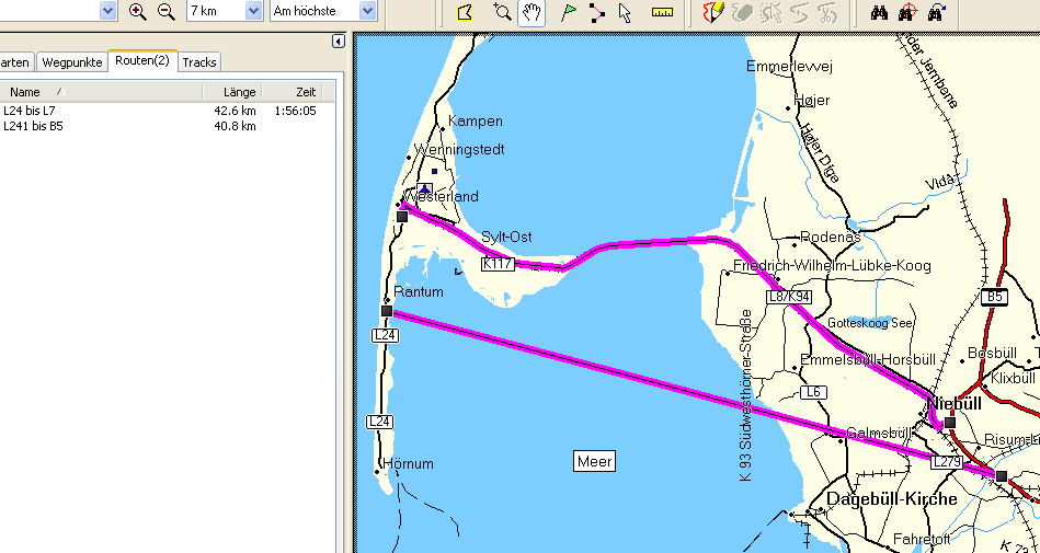
I don't think it's possible to make a routable way out of a relation with mkgmap. So, I choosed the simplest solution and mapped the line as route=shuttle_train. By adding a line like: route=shuttle_train [0x16 road_class=3 road_speed=1 resolution 18] it's possible to create a map which is able to route to sylt. BUT: In MapSource I have the same problem as for the ferry line Emden-Borkum : If the route is too complicated(!?) MS switches to direct-line routing. :-( See attached screen shot. Chris

On Fri, Mar 26, 2010 at 11:47:32AM +0100, Chris-Hein Lunkhusen wrote:
I have a third idea, similar to the first - does a route relation make sense for this?
I don't think it's possible to make a routable way out of a relation with mkgmap.
Why not? I have successfully built a bus route map with some relations and lines rules. Is there something special about routability? I thought that the NET section is created after style file processing.
So, I choosed the simplest solution and mapped the line as route=shuttle_train.
You could set this attribute in the relations file too.
If the route is too complicated(!?) MS switches to direct-line routing. :-(
Sorry, I have no idea about that. The Edge 705 often cheats in bicycle navigation by jumping to car road after a few km, but I haven't seen it switch to direct-line routing yet. But you have a much higher way density I guess. Marko
Marko Mäkelä schrieb:
So, I choosed the simplest solution and mapped the line as route=shuttle_train.
You could set this attribute in the relations file too.
But in this case the problem of the connections to the highway network on the railway-crossings remains.
If the route is too complicated(!?) MS switches to direct-line routing. :-(
Sorry, I have no idea about that. The Edge 705 often cheats in bicycle navigation by jumping to car road after a few km, but I haven't seen it switch to direct-line routing yet. But you have a much higher way density I guess.
I played a little bit with the lines-style-file, changed the road-class from 0 to 1 for residential, unclassified and service and now the routing is fine. So maybe roadclass 0 is not good for routing.... Chris

Attached is a patch that allows you to build routable ways from relations. You use it by adding a [ ... ] section in your relations style file. For example: type=route & route=bicycle & network=tcn { name '${ref|subst: |highway-symbol:box} ${name}' | '${ref|subst: |highway-symbol:box}' | '${name}'; apply { set routable_way_generated=yes; set cycleroute_from_relation=yes; set access=yes; set motorcar=yes; set motorcycle=yes; set bicycle=yes; } } [ 0x02 road_class=2 road_speed=1 level 3 ] All the ways that belong to that relation are converted into the given type. This is done before and in addition the processing using the lines style file. As you can see you can modify the tags of the ways that belong to that relation to avoid generating ways twice by using an appropriate condition in the lines style file. Regards Thilo Am 26.03.2010 um 23:55 schrieb Chris-Hein Lunkhusen:
Marko Mäkelä schrieb:
So, I choosed the simplest solution and mapped the line as route=shuttle_train.
You could set this attribute in the relations file too.
But in this case the problem of the connections to the highway network on the railway-crossings remains.
If the route is too complicated(!?) MS switches to direct-line routing. :-(
Sorry, I have no idea about that. The Edge 705 often cheats in bicycle navigation by jumping to car road after a few km, but I haven't seen it switch to direct-line routing yet. But you have a much higher way density I guess.
I played a little bit with the lines-style-file, changed the road-class from 0 to 1 for residential, unclassified and service and now the routing is fine.
So maybe roadclass 0 is not good for routing....
Chris
_______________________________________________ mkgmap-dev mailing list mkgmap-dev@lists.mkgmap.org.uk http://www.mkgmap.org.uk/mailman/listinfo/mkgmap-dev

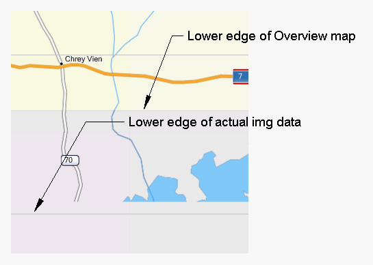
Hi, I am having difficulty getting the overview map align with my osm data. This is the bounding box for the data, <bound box="12.00000,102.31098,14.69655,107.65625"/> This is the bounding box of the Overview map created (mp format) Data0=(12.08496,102.34864),(14.76562,102.34864),(14.76562,107.66602),(12.08496,107.66602) And one tile of the background Map Coverage Area (mp format) Type=0x4b Background=Y Data4=(12.00256,103.64502),(12.67273,103.64502),(12.67273,104.31519),(12.00256,104.31519) The error between the Map Coverage Area and the OSM data is within the range expected (<3m) but the error between the overview map and the map coverage area is about 4.6 km, which is unexpected. Also in mapsource there is a gap of about 580m where the img data is not displayed. The attached picture shows how it looks in Mapsource. My options file in the style gives, levels = 0:24, 1:22, 2:20, 3:18, 4:16 But I have experimented with many different values without it making any difference. I have uploaded the osm file and style file to Dropbox (Dropbox is a nice cross-platform free service for those in need of a place to share files < 3GB total). http://dl.dropbox.com/u/4900023/mp2osmstyle.zip (7KB) http://dl.dropbox.com/u/4900023/d-48.zip (9.2MB) What could I be doing wrong? What options could I experiment with? Where is the code that creates the overview map boundaries? Thanks for any help or suggestions, Garvan
0> In article <hoi3c2$dqb$1@dough.gmane.org>, 0> Chris-Hein Lunkhusen <URL:mailto:chris66nrw@gmx.de> ("CL") wrote: CL> I don't think it's possible to make a routable way out of a relation CL> with mkgmap. Marko has responded to this whilst I was away; I confess I don't fully grok relations processing, as I've never written any myself. The issue with connections at the level crossings isn't avoidable *with the current mkgmap* - but as this is the development list, I hope it's something that can be developed. :-) CL> So, I choosed the simplest solution and mapped the line as CL> route=shuttle_train. Sounds like a good short-term plan. But it would be nice to improve the tools to cope with the more world-oriented representation. Anyway, I'm glad you have something that works for you. Ignore me if I'm too much of an idealist!
participants (5)
-
 Chris-Hein Lunkhusen
 -
 Garvan & maew
 -
 Marko Mäkelä
 -
 Thilo Hannemann
 -
 Toby Speight