splitter and options --description / --geonames-file

Hi all, this is a follow up of http://gis.19327.n8.nabble.com/documentation-improvement-tp5962609p5962747.h... Since I don't use these options for my maps I am unsure what is best. The --geonames-file option tries to find a city within the calculated tile. If none is found it either writes the value given with --description or just a comment. I think it would be best to always write the nearest city. Gerd

Hi Gerd I'd say that if the splitter is going to generate descriptions per tile (geonames) it should generate one for each tile and, if there isn't a centre of a city within the tile and no default description, it should use a modified form of the nearest city to make it unique from a possible adjacent tile that might use the same city. Maybe something like "GB-~Basingstoke", but no solution is ideal and there could still be duplicates. The splitter could keep track of which names were have been used and, for the ones outside the tile, added an increasing suffix number, so would have "GB-Basingstoke-2" etc Ticker On Wed, 2020-04-08 at 08:38 +0000, Gerd Petermann wrote:
Hi all,
this is a follow up of http://gis.19327.n8.nabble.com/documentation-i mprovement-tp5962609p5962747.html
Since I don't use these options for my maps I am unsure what is best. The --geonames-file option tries to find a city within the calculated tile. If none is found it either writes the value given with --description or just a comment. I think it would be best to always write the nearest city.
Gerd _______________________________________________ mkgmap-dev mailing list mkgmap-dev@lists.mkgmap.org.uk http://www.mkgmap.org.uk/mailman/listinfo/mkgmap-dev

Hi, all, The Definition of Google Plus Codes, a.k.a. Opern Location Codes, can be found at https://en.wikipedia.org/wiki/Open_Location_Code The complete code also specifies, by its length, the size of the area being described. When using them in splitter, I have never seen a tile whose code was longer than 8 characters, an area 250m east to west and 125m north to south. I use the largest OLC centered on the tile in question that fits within the tile. Randolph J. Herber On 4/8/2020 4:59 AM, Ticker Berkin wrote:
Hi Gerd
I'd say that if the splitter is going to generate descriptions per tile (geonames) it should generate one for each tile and, if there isn't a centre of a city within the tile and no default description, it should use a modified form of the nearest city to make it unique from a possible adjacent tile that might use the same city.
Maybe something like "GB-~Basingstoke", but no solution is ideal and there could still be duplicates.
The splitter could keep track of which names were have been used and, for the ones outside the tile, added an increasing suffix number, so would have "GB-Basingstoke-2" etc
Ticker
On Wed, 2020-04-08 at 08:38 +0000, Gerd Petermann wrote:
Hi all,
this is a follow up of http://gis.19327.n8.nabble.com/documentation-i mprovement-tp5962609p5962747.html
Since I don't use these options for my maps I am unsure what is best. The --geonames-file option tries to find a city within the calculated tile. If none is found it either writes the value given with --description or just a comment. I think it would be best to always write the nearest city.
Gerd _______________________________________________ mkgmap-dev mailing list mkgmap-dev@lists.mkgmap.org.uk http://www.mkgmap.org.uk/mailman/listinfo/mkgmap-dev
mkgmap-dev mailing list mkgmap-dev@lists.mkgmap.org.uk http://www.mkgmap.org.uk/mailman/listinfo/mkgmap-dev
Hi Randolph, in what situation do you use these codes? I am happy with the mapids generated by splitter. Gerd ________________________________________ Von: mkgmap-dev <mkgmap-dev-bounces@lists.mkgmap.org.uk> im Auftrag von Randolph J. Herber <army.bronze.star@gmail.com> Gesendet: Mittwoch, 8. April 2020 15:13 An: Development list for mkgmap; Ticker Berkin Betreff: Re: [mkgmap-dev] splitter and options --description / --geonames-file Hi, all, The Definition of Google Plus Codes, a.k.a. Opern Location Codes, can be found at https://en.wikipedia.org/wiki/Open_Location_Code The complete code also specifies, by its length, the size of the area being described. When using them in splitter, I have never seen a tile whose code was longer than 8 characters, an area 250m east to west and 125m north to south. I use the largest OLC centered on the tile in question that fits within the tile. Randolph J. Herber On 4/8/2020 4:59 AM, Ticker Berkin wrote:
Hi Gerd
I'd say that if the splitter is going to generate descriptions per tile (geonames) it should generate one for each tile and, if there isn't a centre of a city within the tile and no default description, it should use a modified form of the nearest city to make it unique from a possible adjacent tile that might use the same city.
Maybe something like "GB-~Basingstoke", but no solution is ideal and there could still be duplicates.
The splitter could keep track of which names were have been used and, for the ones outside the tile, added an increasing suffix number, so would have "GB-Basingstoke-2" etc
Ticker
On Wed, 2020-04-08 at 08:38 +0000, Gerd Petermann wrote:
Hi all,
this is a follow up of http://gis.19327.n8.nabble.com/documentation-i mprovement-tp5962609p5962747.html
Since I don't use these options for my maps I am unsure what is best. The --geonames-file option tries to find a city within the calculated tile. If none is found it either writes the value given with --description or just a comment. I think it would be best to always write the nearest city.
Gerd _______________________________________________ mkgmap-dev mailing list mkgmap-dev@lists.mkgmap.org.uk http://www.mkgmap.org.uk/mailman/listinfo/mkgmap-dev
mkgmap-dev mailing list mkgmap-dev@lists.mkgmap.org.uk http://www.mkgmap.org.uk/mailman/listinfo/mkgmap-dev
mkgmap-dev mailing list mkgmap-dev@lists.mkgmap.org.uk http://www.mkgmap.org.uk/mailman/listinfo/mkgmap-dev
Hi all, sorry, I think some mails where not sent to the list. I've attached a patch that adds a number to the city name when --geonames-file is used and multiple tiles are close to that city. I fear I don't know in what situation these names are important. So, please try if this improves something. Gerd ________________________________________ Von: mkgmap-dev <mkgmap-dev-bounces@lists.mkgmap.org.uk> im Auftrag von Gerd Petermann <gpetermann_muenchen@hotmail.com> Gesendet: Mittwoch, 8. April 2020 16:40 An: Development list for mkgmap; Ticker Berkin Betreff: Re: [mkgmap-dev] splitter and options --description / --geonames-file Hi Randolph, in what situation do you use these codes? I am happy with the mapids generated by splitter. Gerd ________________________________________ Von: mkgmap-dev <mkgmap-dev-bounces@lists.mkgmap.org.uk> im Auftrag von Randolph J. Herber <army.bronze.star@gmail.com> Gesendet: Mittwoch, 8. April 2020 15:13 An: Development list for mkgmap; Ticker Berkin Betreff: Re: [mkgmap-dev] splitter and options --description / --geonames-file Hi, all, The Definition of Google Plus Codes, a.k.a. Opern Location Codes, can be found at https://en.wikipedia.org/wiki/Open_Location_Code The complete code also specifies, by its length, the size of the area being described. When using them in splitter, I have never seen a tile whose code was longer than 8 characters, an area 250m east to west and 125m north to south. I use the largest OLC centered on the tile in question that fits within the tile. Randolph J. Herber On 4/8/2020 4:59 AM, Ticker Berkin wrote:
Hi Gerd
I'd say that if the splitter is going to generate descriptions per tile (geonames) it should generate one for each tile and, if there isn't a centre of a city within the tile and no default description, it should use a modified form of the nearest city to make it unique from a possible adjacent tile that might use the same city.
Maybe something like "GB-~Basingstoke", but no solution is ideal and there could still be duplicates.
The splitter could keep track of which names were have been used and, for the ones outside the tile, added an increasing suffix number, so would have "GB-Basingstoke-2" etc
Ticker
On Wed, 2020-04-08 at 08:38 +0000, Gerd Petermann wrote:
Hi all,
this is a follow up of http://gis.19327.n8.nabble.com/documentation-i mprovement-tp5962609p5962747.html
Since I don't use these options for my maps I am unsure what is best. The --geonames-file option tries to find a city within the calculated tile. If none is found it either writes the value given with --description or just a comment. I think it would be best to always write the nearest city.
Gerd _______________________________________________ mkgmap-dev mailing list mkgmap-dev@lists.mkgmap.org.uk http://www.mkgmap.org.uk/mailman/listinfo/mkgmap-dev
mkgmap-dev mailing list mkgmap-dev@lists.mkgmap.org.uk http://www.mkgmap.org.uk/mailman/listinfo/mkgmap-dev
mkgmap-dev mailing list mkgmap-dev@lists.mkgmap.org.uk http://www.mkgmap.org.uk/mailman/listinfo/mkgmap-dev _______________________________________________ mkgmap-dev mailing list mkgmap-dev@lists.mkgmap.org.uk http://www.mkgmap.org.uk/mailman/listinfo/mkgmap-dev
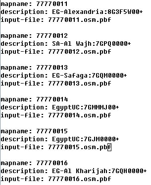
Hi, all! Yes, it helps. It was not what I had in mind. Fragment of template.args showing the OLC or Google Plus Codes that were added. These codes can be directly used to show the area in question: EG-Alexandria:8G3F5W00+ <https://plus.codes/8G3F5W00+> Image of Alexandria, Egypt, area referenced. and for an Egyptian area with no cities with a population as large as 15 000: EgyptUC:7GJM0000+ <https://plus.codes/7GJM0000+> Large area in southern Egypt with no cities as large as 15 thousand people. This area is in southern Egypt. The differences in AreaList.java, in Unix format are in the attached differences file. The modified AreaList.java files in the attached java file. Can you now understand what I want and why? Randolph J. Herber On 4/9/2020 9:48 AM, Gerd Petermann wrote:
Hi all,
sorry, I think some mails where not sent to the list. I've attached a patch that adds a number to the city name when --geonames-file is used and multiple tiles are close to that city.
I fear I don't know in what situation these names are important. So, please try if this improves something.
Gerd
________________________________________ Von: mkgmap-dev <mkgmap-dev-bounces@lists.mkgmap.org.uk> im Auftrag von Gerd Petermann <gpetermann_muenchen@hotmail.com> Gesendet: Mittwoch, 8. April 2020 16:40 An: Development list for mkgmap; Ticker Berkin Betreff: Re: [mkgmap-dev] splitter and options --description / --geonames-file
Hi Randolph,
in what situation do you use these codes? I am happy with the mapids generated by splitter.
Gerd
________________________________________ Von: mkgmap-dev <mkgmap-dev-bounces@lists.mkgmap.org.uk> im Auftrag von Randolph J. Herber <army.bronze.star@gmail.com> Gesendet: Mittwoch, 8. April 2020 15:13 An: Development list for mkgmap; Ticker Berkin Betreff: Re: [mkgmap-dev] splitter and options --description / --geonames-file
Hi, all,
The Definition of Google Plus Codes, a.k.a. Opern Location Codes, can be found at https://en.wikipedia.org/wiki/Open_Location_Code
The complete code also specifies, by its length, the size of the area being described. When using them in splitter, I have never seen a tile whose code was longer than 8 characters, an area 250m east to west and 125m north to south. I use the largest OLC centered on the tile in question that fits within the tile.
Randolph J. Herber
On 4/8/2020 4:59 AM, Ticker Berkin wrote:
Hi Gerd
I'd say that if the splitter is going to generate descriptions per tile (geonames) it should generate one for each tile and, if there isn't a centre of a city within the tile and no default description, it should use a modified form of the nearest city to make it unique from a possible adjacent tile that might use the same city.
Maybe something like "GB-~Basingstoke", but no solution is ideal and there could still be duplicates.
The splitter could keep track of which names were have been used and, for the ones outside the tile, added an increasing suffix number, so would have "GB-Basingstoke-2" etc
Ticker
On Wed, 2020-04-08 at 08:38 +0000, Gerd Petermann wrote:
Hi all,
this is a follow up of http://gis.19327.n8.nabble.com/documentation-i mprovement-tp5962609p5962747.html
Since I don't use these options for my maps I am unsure what is best. The --geonames-file option tries to find a city within the calculated tile. If none is found it either writes the value given with --description or just a comment. I think it would be best to always write the nearest city.
Gerd _______________________________________________ mkgmap-dev mailing list mkgmap-dev@lists.mkgmap.org.uk http://www.mkgmap.org.uk/mailman/listinfo/mkgmap-dev
mkgmap-dev mailing list mkgmap-dev@lists.mkgmap.org.uk http://www.mkgmap.org.uk/mailman/listinfo/mkgmap-dev
mkgmap-dev mailing list mkgmap-dev@lists.mkgmap.org.uk http://www.mkgmap.org.uk/mailman/listinfo/mkgmap-dev _______________________________________________ mkgmap-dev mailing list mkgmap-dev@lists.mkgmap.org.uk http://www.mkgmap.org.uk/mailman/listinfo/mkgmap-dev
_______________________________________________ mkgmap-dev mailing list mkgmap-dev@lists.mkgmap.org.uk http://www.mkgmap.org.uk/mailman/listinfo/mkgmap-dev
Hi Randolph, when I want to visualize the calulcated areas I use --write-kml=splitter.kml. The output file splitter.kml can be used in JOSM (with a plugin) as well as in Google Earth, if you prefer that. The use in JOSM helps me to find issues where a tile border might be involved. Anyhow, if others are interested I would use your patch with a different option, something like --add-google-plus which would either add the code to the city name or to the given description or to an empty string so that splitter would always generate a unique tile description. Gerd ________________________________________ Von: Randolph J. Herber <army.bronze.star@gmail.com> Gesendet: Freitag, 10. April 2020 02:17 An: Development list for mkgmap; Gerd Petermann; Mike Baggaley; Ticker Berkin Betreff: Re: [mkgmap-dev] splitter and options --description / --geonames-file Hi, all! Yes, it helps. It was not what I had in mind. [Fragment of template.args showing the OLC or Google Plus Codes that were added.] These codes can be directly used to show the area in question: EG-Alexandria:8G3F5W00+<https://plus.codes/8G3F5W00+> [Image of Alexandria, Egypt, area referenced.] and for an Egyptian area with no cities with a population as large as 15 000: EgyptUC:7GJM0000+<https://plus.codes/7GJM0000+> [Large area in southern Egypt with no cities as large as 15 thousand people.] This area is in southern Egypt. The differences in AreaList.java, in Unix format are in the attached differences file. The modified AreaList.java files in the attached java file. Can you now understand what I want and why? Randolph J. Herber On 4/9/2020 9:48 AM, Gerd Petermann wrote: Hi all, sorry, I think some mails where not sent to the list. I've attached a patch that adds a number to the city name when --geonames-file is used and multiple tiles are close to that city. I fear I don't know in what situation these names are important. So, please try if this improves something. Gerd ________________________________________ Von: mkgmap-dev <mkgmap-dev-bounces@lists.mkgmap.org.uk><mailto:mkgmap-dev-bounces@lists.mkgmap.org.uk> im Auftrag von Gerd Petermann <gpetermann_muenchen@hotmail.com><mailto:gpetermann_muenchen@hotmail.com> Gesendet: Mittwoch, 8. April 2020 16:40 An: Development list for mkgmap; Ticker Berkin Betreff: Re: [mkgmap-dev] splitter and options --description / --geonames-file Hi Randolph, in what situation do you use these codes? I am happy with the mapids generated by splitter. Gerd ________________________________________ Von: mkgmap-dev <mkgmap-dev-bounces@lists.mkgmap.org.uk><mailto:mkgmap-dev-bounces@lists.mkgmap.org.uk> im Auftrag von Randolph J. Herber <army.bronze.star@gmail.com><mailto:army.bronze.star@gmail.com> Gesendet: Mittwoch, 8. April 2020 15:13 An: Development list for mkgmap; Ticker Berkin Betreff: Re: [mkgmap-dev] splitter and options --description / --geonames-file Hi, all, The Definition of Google Plus Codes, a.k.a. Opern Location Codes, can be found at https://en.wikipedia.org/wiki/Open_Location_Code The complete code also specifies, by its length, the size of the area being described. When using them in splitter, I have never seen a tile whose code was longer than 8 characters, an area 250m east to west and 125m north to south. I use the largest OLC centered on the tile in question that fits within the tile. Randolph J. Herber On 4/8/2020 4:59 AM, Ticker Berkin wrote: Hi Gerd I'd say that if the splitter is going to generate descriptions per tile (geonames) it should generate one for each tile and, if there isn't a centre of a city within the tile and no default description, it should use a modified form of the nearest city to make it unique from a possible adjacent tile that might use the same city. Maybe something like "GB-~Basingstoke", but no solution is ideal and there could still be duplicates. The splitter could keep track of which names were have been used and, for the ones outside the tile, added an increasing suffix number, so would have "GB-Basingstoke-2" etc Ticker On Wed, 2020-04-08 at 08:38 +0000, Gerd Petermann wrote: Hi all, this is a follow up of http://gis.19327.n8.nabble.com/documentation-i mprovement-tp5962609p5962747.html Since I don't use these options for my maps I am unsure what is best. The --geonames-file option tries to find a city within the calculated tile. If none is found it either writes the value given with --description or just a comment. I think it would be best to always write the nearest city. Gerd _______________________________________________ mkgmap-dev mailing list mkgmap-dev@lists.mkgmap.org.uk<mailto:mkgmap-dev@lists.mkgmap.org.uk> http://www.mkgmap.org.uk/mailman/listinfo/mkgmap-dev _______________________________________________ mkgmap-dev mailing list mkgmap-dev@lists.mkgmap.org.uk<mailto:mkgmap-dev@lists.mkgmap.org.uk> http://www.mkgmap.org.uk/mailman/listinfo/mkgmap-dev _______________________________________________ mkgmap-dev mailing list mkgmap-dev@lists.mkgmap.org.uk<mailto:mkgmap-dev@lists.mkgmap.org.uk> http://www.mkgmap.org.uk/mailman/listinfo/mkgmap-dev _______________________________________________ mkgmap-dev mailing list mkgmap-dev@lists.mkgmap.org.uk<mailto:mkgmap-dev@lists.mkgmap.org.uk> http://www.mkgmap.org.uk/mailman/listinfo/mkgmap-dev _______________________________________________ mkgmap-dev mailing list mkgmap-dev@lists.mkgmap.org.uk<mailto:mkgmap-dev@lists.mkgmap.org.uk> http://www.mkgmap.org.uk/mailman/listinfo/mkgmap-dev
Hi I'd go for the idea of having the specific option eg --add-google-plus. Also, as a slight modification to the patch that increases the area beyond the tile looking for a city, maybe limit it double the tile size before giving up and just describing the tile with the mapName. Ticker On Fri, 2020-04-10 at 06:46 +0000, Gerd Petermann wrote:
Hi Randolph,
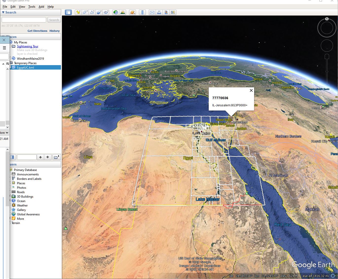
when I want to visualize the calulcated areas I use --write -kml=splitter.kml. The output file splitter.kml can be used in JOSM (with a plugin) as well as in Google Earth, if you prefer that. The use in JOSM helps me to find issues where a tile border might be involved.
Anyhow, if others are interested I would use your patch with a different option, something like --add-google-plus which would either add the code to the city name or to the given description or to an empty string so that splitter would always generate a unique tile description.
Gerd
________________________________________ Von: Randolph J. Herber <army.bronze.star@gmail.com> Gesendet: Freitag, 10. April 2020 02:17 An: Development list for mkgmap; Gerd Petermann; Mike Baggaley; Ticker Berkin Betreff: Re: [mkgmap-dev] splitter and options --description / - -geonames-file
Hi, all!
Yes, it helps.
It was not what I had in mind.
[Fragment of template.args showing the OLC or Google Plus Codes that were added.]
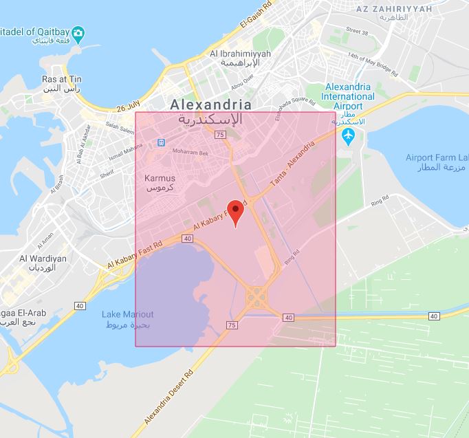
These codes can be directly used to show the area in question: EG -Alexandria:8G3F5W00+<https://plus.codes/8G3F5W00+>
[Image of Alexandria, Egypt, area referenced.]
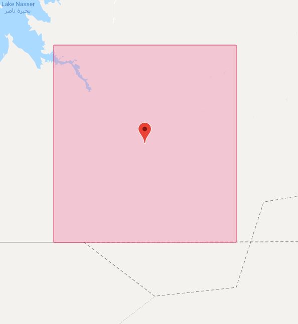
and for an Egyptian area with no cities with a population as large as 15 000: EgyptUC:7GJM0000+<https://plus.codes/7GJM0000+>
[Large area in southern Egypt with no cities as large as 15 thousand people.]
This area is in southern Egypt.
The differences in AreaList.java, in Unix format are in the attached differences file.
The modified AreaList.java files in the attached java file.
Can you now understand what I want and why?
Randolph J. Herber
On 4/9/2020 9:48 AM, Gerd Petermann wrote:
Hi all,
sorry, I think some mails where not sent to the list. I've attached a patch that adds a number to the city name when --geonames-file is used and multiple tiles are close to that city.
I fear I don't know in what situation these names are important. So, please try if this improves something.
Gerd
Hi, all, I agree with the addition of the option --add-google-plus. Since I do not know the locations of most villages, town, and cities in the cities500 file, naming the tiles after such entities is not as helpful as I would like. My problems occur in Garmin MapSource and in Garmin devices (I have over a dozen), where the tile description is often the only indication of the location of the problem. The villages, towns, and cities' name at least make the descriptions unique. That is why I prefer a description that gives me a location directly. I found out why I was not getting the KML file that I had requested. The problem came from not reading the splitter documentation carefully enough . I had overlooked the error message that would have told me the file's proposed directory did not exist. I got the kml file and used Google Earth to view it. No labels appear directly. I clicked on the tile in the northeast tile to see the text bubble. A dictionary is not a thesaurus. A dictionary helps find the meaning of a word. A thesaurus helps finding a word for a meaning. Ein Wörterbuch ist kein Thesaurus. Ein Wörterbuch hilft dabei, die Bedeutung eines Wortes zu finden. Ein Thesaurus hilft dabei, ein Wort für eine Bedeutung zu finden. I am trying to go the opposite direction than the other suggestions. As for the licensing issues, please see Google Plus Codes Terms of Use <https://plus.codes/terms>. They are quite liberal. Randolph J. Herber On 4/10/2020 3:21 AM, Ticker Berkin wrote:
Hi
I'd go for the idea of having the specific option eg --add-google-plus.
Also, as a slight modification to the patch that increases the area beyond the tile looking for a city, maybe limit it double the tile size before giving up and just describing the tile with the mapName.
Ticker
On Fri, 2020-04-10 at 06:46 +0000, Gerd Petermann wrote:
Hi Randolph,
when I want to visualize the calulcated areas I use --write -kml=splitter.kml. The output file splitter.kml can be used in JOSM (with a plugin) as well as in Google Earth, if you prefer that. The use in JOSM helps me to find issues where a tile border might be involved.
Anyhow, if others are interested I would use your patch with a different option, something like --add-google-plus which would either add the code to the city name or to the given description or to an empty string so that splitter would always generate a unique tile description.
Gerd
________________________________________ Von: Randolph J. Herber <army.bronze.star@gmail.com> Gesendet: Freitag, 10. April 2020 02:17 An: Development list for mkgmap; Gerd Petermann; Mike Baggaley; Ticker Berkin Betreff: Re: [mkgmap-dev] splitter and options --description / - -geonames-file
Hi, all!
Yes, it helps.
It was not what I had in mind.
[Fragment of template.args showing the OLC or Google Plus Codes that were added.]
These codes can be directly used to show the area in question: EG -Alexandria:8G3F5W00+<https://plus.codes/8G3F5W00+>
[Image of Alexandria, Egypt, area referenced.]
and for an Egyptian area with no cities with a population as large as 15 000: EgyptUC:7GJM0000+<https://plus.codes/7GJM0000+>
[Large area in southern Egypt with no cities as large as 15 thousand people.]
This area is in southern Egypt.
The differences in AreaList.java, in Unix format are in the attached differences file.
The modified AreaList.java files in the attached java file.
Can you now understand what I want and why?
Randolph J. Herber
On 4/9/2020 9:48 AM, Gerd Petermann wrote:
Hi all,
sorry, I think some mails where not sent to the list. I've attached a patch that adds a number to the city name when --geonames-file is used and multiple tiles are close to that city.
I fear I don't know in what situation these names are important. So, please try if this improves something.
Gerd
mkgmap-dev mailing list mkgmap-dev@lists.mkgmap.org.uk http://www.mkgmap.org.uk/mailman/listinfo/mkgmap-dev
Hi, all! It would be best if each title has its own, separate identity. Randolph J. Herber On 4/8/2020 3:38 AM, Gerd Petermann wrote:
Hi all,
this is a follow up of http://gis.19327.n8.nabble.com/documentation-improvement-tp5962609p5962747.h...
Since I don't use these options for my maps I am unsure what is best. The --geonames-file option tries to find a city within the calculated tile. If none is found it either writes the value given with --description or just a comment. I think it would be best to always write the nearest city.
Gerd _______________________________________________ mkgmap-dev mailing list mkgmap-dev@lists.mkgmap.org.uk http://www.mkgmap.org.uk/mailman/listinfo/mkgmap-dev
participants (4)
-
 Gerd Petermann
 -
Gerd Petermann
-
 Randolph J. Herber
 -
 Ticker Berkin