
Dear developers, there was a discussion about changing the header of the img files in a way they will load on a newer Garmin marine device (e.g. GPSMap 4xx, 5xx): http://www.mkgmap.org.uk/pipermail/mkgmap-dev/2010q1/006427.html As a workaround, a tool called Marinator can patch the img files for making them usable on newer marine devices: http://www.mediafire.com/file/muizdgzyewz/BlueChartG2_Marinator.rar Having to use this tool, there is no way to produce a gmapsupp that works on marine devices directly with mkgmap. You will always have to create a MapSource version, patch the imgs and then create a gmapsupp. This makes it impossible to produce marine maps automatically under linux. Is there a chance to modify mkgmap in a way the maps do not have to be patched anymore?

Hi
http://www.mkgmap.org.uk/pipermail/mkgmap-dev/2010q1/006427.html
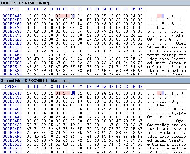
Summary of that is to change a number in the header: writer.put3(displayPriority); - writer.putInt(0x110301); + writer.putInt(0x170401);
Is there a chance to modify mkgmap in a way the maps do not have to be patched anymore?
When that patch, is there any affect on normal operation? Since we don't know what those numbers are for, we may as well change them, unless someone knows what they are for and knows a reason why not. ..Steve

On 05.03.2012 16:22, Steve Ratcliffe wrote:
Hi
http://www.mkgmap.org.uk/pipermail/mkgmap-dev/2010q1/006427.html
Summary of that is to change a number in the header: writer.put3(displayPriority); - writer.putInt(0x110301); + writer.putInt(0x170401);
Is there a chance to modify mkgmap in a way the maps do not have to be patched anymore? When that patch, is there any affect on normal operation? Since we don't know what those numbers are for, we may as well change them, unless someone knows what they are for and knows a reason why not.
..Steve Yes, maps will not be shown on Mapsource anymore. Also there will be problems regarding altitude profiles and different options regarding visibility on the GPSrs.
Marine mode shouldn't be the default... However the change highlighted above has nothing to do with Marine mode, it affects the rerouting sensivity, and is useful if the user is expected never to be faster than ~15km/h (from switching on the GPS), in that case 0x170401 will lead to offer rerouting like if the speed had been reached. However it creates problems if used at car speed, cause rerouting will be too often offered/recalculated. See thread here: http://www.mail-archive.com/mkgmap-dev@lists.mkgmap.org.uk/msg00368.html Besides Marine mode header can be changed via gmt too, and that is also available for Linux (gmt is the execution part of gmaptool).
_______________________________________________ mkgmap-dev mailing list mkgmap-dev@lists.mkgmap.org.uk http://www.mkgmap.org.uk/mailman/listinfo/mkgmap-dev
bounces@lists.mkgmap.org.uk] Im Auftrag von Felix Hartmann
Yes, maps will not be shown on Mapsource anymore.
When I patch the imgs with "Marinator" to marine header, they are displayed properly in Mapsource.
Marine mode shouldn't be the default...
I´d also prefer a new option --marine-mode so we can select the correct header for each type of map.
On 05/03/12 15:39, Felix Hartmann wrote:
Besides Marine mode header can be changed via gmt too, and that is also available for Linux (gmt is the execution part of gmaptool).
Is that the -r option? That does not do anything to the .img files, but sets the byte at 0x21 to 1 in the .tdb file. The resulting tdb appears to work in mapsource. ..Steve
Betreff: Re: [mkgmap-dev] Garmin Marine Devices
On 05/03/12 15:39, Felix Hartmann wrote:
Besides Marine mode header can be changed via gmt too, and that is also available for Linux (gmt is the execution part of gmaptool).
Is that the -r option? That does not do anything to the .img files, but sets the byte at 0x21 to 1 in the .tdb file.
The resulting tdb appears to work in mapsource.
..Steve
On the attached screenshot please find the only two bytes to change for marine usage. It has no effect to Mapsource.
participants (3)
-
 Felix Hartmann
 -
 RheinSkipper
 -
 Steve Ratcliffe