Commit: r868: Implement routing for .osm input files.

Version 868 was commited by steve on 2009-02-09 22:15:14 +0000 (Mon, 09 Feb 2009) Implement routing for .osm input files. -Mark Burton

0> In article <20090209221514.E6A30274043@lachesis.vm.bytemark.co.uk>, 0> svn commit <URL:mailto:svn@mkgmap.org.uk> ("Svn") wrote: Svn> Version 868 was commited by steve on 2009-02-09 22:15:14 +0000 (Mon, 09 Feb 2009) Svn> Svn> Implement routing for .osm input files. Svn> Svn> -Mark Burton O O * \___/ Very pleased to see this! Can't try it until this afternoon, but I'm now itching with impatience... Thank you for all your work! :-)

Hi Toby,
Svn> Version 868 was commited by steve on 2009-02-09 22:15:14 +0000 (Mon, 09 Feb 2009)
The commit email doesn't make it obvious, but the new code has been committed to to the nod branch, not the trunk. If you are using your own style files (rather than the default) you will need to put in the road classes and speeds (as in the default lines file). Please try it out on as many OSM files as you can and report success/failure. All feedback is welcome. Cheers, Mark

The commit email doesn't make it obvious, but the new code has been committed to to the nod branch, not the trunk.
Only for clarification: How is the nod-branch to be considered? Is it the working branch and only tested features get the way into the main branch? As far as I know the routing capabilities are merged to the main trunk now.
Hi Johann,
The commit email doesn't make it obvious, but the new code has been committed to to the nod branch, not the trunk.
Only for clarification: How is the nod-branch to be considered? Is it the working branch and only tested features get the way into the main branch? As far as I know the routing capabilities are merged to the main trunk now.
That's true and I was surprised to see the new support for routing from OSM files had been checked into a branch (rather than trunk) as the new code has little impact when --route is not being specified and doesn't affect the routing when the input is from a mp file. So, just in case it's useful, I have attached a patch of my latest code. It's relative to the current trunk (rather than the nod branch which actually contains most of it). It should support routable ferry routes. Cheers, Mark

Given that I'm comparing gmapsupp.img files for combined England, Scotland and Wales previously created by using osm2mp and mkgmap with .mp files and now directly with mkgmap from .osm files then the initial observations are:- Using the osm2mp method gives a final file of 119.8MB where the direct conversion gives a final file of 103.7MB Support for roundabouts seems less well implemented. On approaching a roundabout I would previously receive an instruction to "Take 3rd exit at roundabout". Approaching the same roundabout I was simply told to "Keep left to Bloggs Road" even though I needed the 3rd exit. Slightly different routes are now chosen. These are not wrong - Just different to before. e.g. Leaving work I always ignore the Garmin route as it's not the best. When it recalculated it previously chose the route I actually take. Using the new file it picked a different route which I had to ignore a second time before it chose the route I actually take. I also noticed today that with both versions of the .img file any routing from the Rochdale area along the M62 fails at around the point that the M621 splits from the M62 (approximately J27). I realise there could be many reasons for this but I thought I'd mention it. For information purposes the pseudo code I use to create the files is:- java -jar splitter.jar england.osm osm2mp.pl --nocodepage --splitroads *.osm > e*.mp (5 files total) java -Xmx2048M -jar mkgmap.jar --latin1 --gmapsupp --route e?.mp wales.mp scotland.mp java -jar splitter.jar england.osm java -Xmx2048M -jar mkgmap.jar --latin1 --gmapsupp --route e?.osm wales.osm scotland.osm Hope that helps Paul Mark Burton wrote:
Hi Toby,
Svn> Version 868 was commited by steve on 2009-02-09 22:15:14 +0000 (Mon, 09 Feb 2009)
The commit email doesn't make it obvious, but the new code has been committed to to the nod branch, not the trunk.
If you are using your own style files (rather than the default) you will need to put in the road classes and speeds (as in the default lines file).
Please try it out on as many OSM files as you can and report success/failure.
All feedback is welcome.
Cheers,
Mark _______________________________________________ mkgmap-dev mailing list mkgmap-dev@lists.mkgmap.org.uk http://www.mkgmap.org.uk/mailman/listinfo/mkgmap-dev
Hi Paul, Thanks a lot for the feedback. From what you report, it sounds like the new map worked quite well with no really bad problems.
Given that I'm comparing gmapsupp.img files for combined England, Scotland and Wales previously created by using osm2mp and mkgmap with .mp files and now directly with mkgmap from .osm files then the initial observations are:-
Using the osm2mp method gives a final file of 119.8MB where the direct conversion gives a final file of 103.7MB
Hmm, did it only include 90% of the roads?
Support for roundabouts seems less well implemented. On approaching a roundabout I would previously receive an instruction to "Take 3rd exit at roundabout". Approaching the same roundabout I was simply told to "Keep left to Bloggs Road" even though I needed the 3rd exit.
OK - the attached new lines file should fix that (this goes in resources/styles/default).
Slightly different routes are now chosen. These are not wrong - Just different to before. e.g. Leaving work I always ignore the Garmin route as it's not the best. When it recalculated it previously chose the route I actually take. Using the new file it picked a different route which I had to ignore a second time before it chose the route I actually take.
Was the new route completely silly or merely sub-optimal? If the later, how could it have improved the route? Tweaking of the road classes and speeds in the lines file should alter the behaviour so you could try adjusting those values. I thought I had set them to the same values used by osm2mp.
I also noticed today that with both versions of the .img file any routing from the Rochdale area along the M62 fails at around the point that the M621 splits from the M62 (approximately J27). I realise there could be many reasons for this but I thought I'd mention it.
Does a split between map tiles occur there?
For information purposes the pseudo code I use to create the files is:-
java -jar splitter.jar england.osm osm2mp.pl --nocodepage --splitroads *.osm > e*.mp (5 files total) java -Xmx2048M -jar mkgmap.jar --latin1 --gmapsupp --route e?.mp wales.mp scotland.mp
java -jar splitter.jar england.osm java -Xmx2048M -jar mkgmap.jar --latin1 --gmapsupp --route e?.osm wales.osm scotland.osm
Cheers, Mark
Using the osm2mp method gives a final file of 119.8MB where the direct conversion gives a final file of 103.7MB
Hmm, did it only include 90% of the roads?
For me my file is also a little smaller. The osm2mp converted one has 13.3MB, the direct converted one has 13.1 MB. Not that much difference. I miss no roads, routing is the same with both files. For the moment I see absolutely no difference. Thank you for your great work.
Hi Johann,
For me my file is also a little smaller. The osm2mp converted one has 13.3MB, the direct converted one has 13.1 MB. Not that much difference. I miss no roads, routing is the same with both files. For the moment I see absolutely no difference.
Very good. BTW - the lines file needs to be updated (see earlier message to Paul) to make routing on roundabouts work as before. Incidentally, I am currently looking at a route on my etrex where the graphical description (aka picture on the screen) shows taking the second exit at a particular roundabout (which is correct) but the text that goes with the picture says, take the first exit (which is wrong!) - not sure what's happening there.
Thank you for your great work.
Shucks, it was nothing - actually, that's not just me being modest because all I did was fill in a few missing gaps - Steve (and others) had already done the bulk of the required work earlier. Cheers, Mark
Mark Burton wrote: <snip>
Incidentally, I am currently looking at a route on my etrex where the graphical description (aka picture on the screen) shows taking the second exit at a particular roundabout (which is correct) but the text that goes with the picture says, take the first exit (which is wrong!) - not sure what's happening there.
There's loads of occurrences of this. If it's the ame thing as I have seen then it's where the last node of the road you're on and the first node of the first road off the roundabout are the same node.
Thank you for your great work.
Paul
Paul,
Incidentally, I am currently looking at a route on my etrex where the graphical description (aka picture on the screen) shows taking the second exit at a particular roundabout (which is correct) but the text that goes with the picture says, take the first exit (which is wrong!) - not sure what's happening there.
There's loads of occurrences of this. If it's the ame thing as I have seen then it's where the last node of the road you're on and the first node of the first road off the roundabout are the same node.
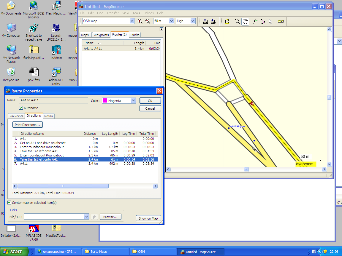
Actually, that isn't so in this case. Please see attached screenshot showing mapsource windows - mapsource seems to do the same as the gps in this situation. In the route properties window, it says take 1st left. In the graphical window, it shows the correct route (2nd exit). I wonder if it's because everything is highway=trunk except for the road at the first exit which is highway=secondary? Cheers, Mark

Hi, I tried the latest snapshot: mkgmap-latest.tar.gz Feb 11 01:41 mkgmap-latest.tar.gz And tested in my Garmin, I generated the img with this: java -Xmx512m -jar mkgmap.jar --latin1 --gmapsupp --route philippines.osm The file is 4.5 MB, my previous routable map from mkgmap-route-r806 is 8.5 MB. The city search is working but cities have the following label: i.e. Las Pinas, GBR AFAIK GBR is for Great Britain The routing defaults to the Garmin supplied map and not the OSM mkgmap output. Any idea why? On Wed, Feb 11, 2009 at 6:28 AM, Mark Burton <markb@ordern.com> wrote:
Paul,
Incidentally, I am currently looking at a route on my etrex where the graphical description (aka picture on the screen) shows taking the second exit at a particular roundabout (which is correct) but the text that goes with the picture says, take the first exit (which is wrong!) - not sure what's happening there.
There's loads of occurrences of this. If it's the ame thing as I have seen then it's where the last node of the road you're on and the first node of the first road off the roundabout are the same node.
Actually, that isn't so in this case. Please see attached screenshot showing mapsource windows - mapsource seems to do the same as the gps in this situation.
In the route properties window, it says take 1st left.
In the graphical window, it shows the correct route (2nd exit).
I wonder if it's because everything is highway=trunk except for the road at the first exit which is highway=secondary?
Cheers,
Mark
_______________________________________________ mkgmap-dev mailing list mkgmap-dev@lists.mkgmap.org.uk http://www.mkgmap.org.uk/mailman/listinfo/mkgmap-dev
-- cheers, maning ------------------------------------------------------ "Freedom is still the most radical idea of all" -N.Branden wiki: http://esambale.wikispaces.com/ blog: http://epsg4253.wordpress.com/ ------------------------------------------------------
Hi,
I tried the latest snapshot:
mkgmap-latest.tar.gz Feb 11 01:41 mkgmap-latest.tar.gz
And tested in my Garmin, I generated the img with this:
java -Xmx512m -jar mkgmap.jar --latin1 --gmapsupp --route philippines.osm
The file is 4.5 MB, my previous routable map from mkgmap-route-r806 is 8.5 MB.
The city search is working but cities have the following label: i.e. Las Pinas, GBR
AFAIK GBR is for Great Britain
The routing defaults to the Garmin supplied map and not the OSM mkgmap output.
Any idea why?
OK - 2 things: 1 - the OSM routing is not yet in the main SVN trunk so it won't be in the snapshot file. You need to check out the nod branch from the SVN repository. 2 - to avoid the GBR, you need to give a --country-abbr="???" option. Cheers, Mark
On Wed, Feb 11, 2009 at 6:26 PM, Mark Burton <markb@ordern.com> wrote:
Hi,
I tried the latest snapshot:
mkgmap-latest.tar.gz Feb 11 01:41 mkgmap-latest.tar.gz
And tested in my Garmin, I generated the img with this:
java -Xmx512m -jar mkgmap.jar --latin1 --gmapsupp --route philippines.osm
The file is 4.5 MB, my previous routable map from mkgmap-route-r806 is 8.5 MB.
The city search is working but cities have the following label: i.e. Las Pinas, GBR
AFAIK GBR is for Great Britain
The routing defaults to the Garmin supplied map and not the OSM mkgmap output.
Any idea why?
OK - 2 things:
1 - the OSM routing is not yet in the main SVN trunk so it won't be in the snapshot file. You need to check out the nod branch from the SVN repository.
2 - to avoid the GBR, you need to give a --country-abbr="???" option.
Cheers,
Mark _______________________________________________ mkgmap-dev mailing list mkgmap-dev@lists.mkgmap.org.uk http://www.mkgmap.org.uk/mailman/listinfo/mkgmap-dev
Thanks! Now it's OK. Will test them soon. As posted by others, the file is a little bit smaller (from 8.4 MB to just 8.0 MB) -- cheers, maning ------------------------------------------------------ "Freedom is still the most radical idea of all" -N.Branden wiki: http://esambale.wikispaces.com/ blog: http://epsg4253.wordpress.com/ ------------------------------------------------------
Mark Burton wrote:
Hi Paul,
Thanks a lot for the feedback. From what you report, it sounds like the new map worked quite well with no really bad problems.
Given that I'm comparing gmapsupp.img files for combined England, Scotland and Wales previously created by using osm2mp and mkgmap with .mp files and now directly with mkgmap from .osm files then the initial observations are:-
Using the osm2mp method gives a final file of 119.8MB where the direct conversion gives a final file of 103.7MB
Hmm, did it only include 90% of the roads?
I don't know how you'd tell!!
Support for roundabouts seems less well implemented. On approaching a roundabout I would previously receive an instruction to "Take 3rd exit at roundabout". Approaching the same roundabout I was simply told to "Keep left to Bloggs Road" even though I needed the 3rd exit.
OK - the attached new lines file should fix that (this goes in resources/styles/default).
Helped but is still not as it was but I note that r877 has roundabout updates. A quick glance at the text description for a route using r877 has the "Take 3rd exit at roundabout" direction so this may already have been fixed. I'll see what the graphical map does when I go home
Slightly different routes are now chosen. These are not wrong - Just different to before. e.g. Leaving work I always ignore the Garmin route as it's not the best. When it recalculated it previously chose the route I actually take. Using the new file it picked a different route which I had to ignore a second time before it chose the route I actually take.
Was the new route completely silly or merely sub-optimal? If the later, how could it have improved the route?
Sub-optimal. The best route home for me is to use 2 motorways (think the 2 shortest sides of a triangle) whereas the Garmin has always tried to send me along the hypoteneuse. Unfortunately whilst this is shorter this is an A road which goes through three middle sized towns and therefore has traffic lights B roads etc all the way along so takes considerably longer. Previously after the first recalculation the Garmin would send me along the motorway. Now it tries to get me back onto the A road until the second recalculation.
Tweaking of the road classes and speeds in the lines file should alter the behaviour so you could try adjusting those values. I thought I had set them to the same values used by osm2mp.
I also noticed today that with both versions of the .img file any routing from the Rochdale area along the M62 fails at around the point that the M621 splits from the M62 (approximately J27). I realise there could be many reasons for this but I thought I'd mention it.
Does a split between map tiles occur there?
Yes the split in the tiles would appear to be here. Further testing *"suggests"* that I can't route anywhere off the starting tile. I could try increasing the overlap in splitter to see if this helps but I also don't seem to be able to route into Scotland or Wales. I've also noticed these places show in the "Find Cities" list without distance or direction. Cheers Paul
Hi Paul,
Thanks a lot for the feedback. From what you report, it sounds like the new map worked quite well with no really bad problems.
Given that I'm comparing gmapsupp.img files for combined England, Scotland and Wales previously created by using osm2mp and mkgmap with .mp files and now directly with mkgmap from .osm files then the initial observations are:-
Using the osm2mp method gives a final file of 119.8MB where the direct conversion gives a final file of 103.7MB
Hmm, did it only include 90% of the roads?
I don't know how you'd tell!!
I think others are seeing similar shrinkage and nobody, yet, has reported any missing roads.
Support for roundabouts seems less well implemented. On approaching a roundabout I would previously receive an instruction to "Take 3rd exit at roundabout". Approaching the same roundabout I was simply told to "Keep left to Bloggs Road" even though I needed the 3rd exit.
OK - the attached new lines file should fix that (this goes in resources/styles/default).
Helped but is still not as it was but I note that r877 has roundabout updates. A quick glance at the text description for a route using r877 has the "Take 3rd exit at roundabout" direction so this may already have been fixed. I'll see what the graphical map does when I go home
Yes, it now knows about exits but, as you know, there is still a problem with the text citing the wrong exit.
Slightly different routes are now chosen. These are not wrong - Just different to before. e.g. Leaving work I always ignore the Garmin route as it's not the best. When it recalculated it previously chose the route I actually take. Using the new file it picked a different route which I had to ignore a second time before it chose the route I actually take.
Was the new route completely silly or merely sub-optimal? If the later, how could it have improved the route?
Sub-optimal. The best route home for me is to use 2 motorways (think the 2 shortest sides of a triangle) whereas the Garmin has always tried to send me along the hypoteneuse. Unfortunately whilst this is shorter this is an A road which goes through three middle sized towns and therefore has traffic lights B roads etc all the way along so takes considerably longer.
I believe it is a common gripe that the Garmin does not pay any attention to traffic lights.
Previously after the first recalculation the Garmin would send me along the motorway. Now it tries to get me back onto the A road until the second recalculation.
OK - don't know why that should be.
Tweaking of the road classes and speeds in the lines file should alter the behaviour so you could try adjusting those values. I thought I had set them to the same values used by osm2mp.
I also noticed today that with both versions of the .img file any routing from the Rochdale area along the M62 fails at around the point that the M621 splits from the M62 (approximately J27). I realise there could be many reasons for this but I thought I'd mention it.
Does a split between map tiles occur there?
Yes the split in the tiles would appear to be here. Further testing *"suggests"* that I can't route anywhere off the starting tile. I could try increasing the overlap in splitter to see if this helps but I also don't seem to be able to route into Scotland or Wales. I've also noticed these places show in the "Find Cities" list without distance or direction.
Yes, inter-tile routing is not yet supported. It's in the pipeline... Cheers, Mark

Using the osm2mp method gives a final file of 119.8MB where the direct conversion gives a final file of 103.7MB
Hmm, did it only include 90% of the roads?
I don't know how you'd tell!!
I think others are seeing similar shrinkage and nobody, yet, has reported any missing roads.
This is using the splitter.jar, right? What might be happening: The splitter's output contains a bounding box, and all data within a somewhat larger box. If mkgmap reads that .osm-file, it will clip all data to the bounding box. osm2mp on the other hand will disregard the bounding box and convert all data to .mp. If you then compile the .mp- file, you should get that extra safety margin also, which may well amount to 10%.
Sub-optimal. The best route home for me is to use 2 motorways (think the 2 shortest sides of a triangle) whereas the Garmin has always tried to send me along the hypoteneuse. Unfortunately whilst this is shorter this is an A road which goes through three middle sized towns and therefore has traffic lights B roads etc all the way along so takes considerably longer.
You could try putting some special tags on this A-road: traffic_lights=many or expected_speed=low (these could be autogenerated in a preprocessing step). Then edit the "lines" file to give them a lower speed and/or class. Cheers Robert
Yes, inter-tile routing is not yet supported. It's in the pipeline...
How far is it from the end of the pipeline? As far as i understand, the only thing to do, is to mark all nodes on the border as border nodes. As mkgmap cuts the map at the bounds and calculates new border nodes this should not be a big problem. Should I hava a look into that, or will this be double workl, as you are nearly finished with it?
Hi Johann,
Yes, inter-tile routing is not yet supported. It's in the pipeline...
How far is it from the end of the pipeline?
As far as i understand, the only thing to do, is to mark all nodes on the border as border nodes. As mkgmap cuts the map at the bounds and calculates new border nodes this should not be a big problem.
Should I hava a look into that, or will this be double workl, as you are nearly finished with it?
I have some rough code that needs a little more work and then it can be tested - should be available in the next day or so. Cheers, Mark
I have some rough code that needs a little more work and then it can be tested - should be available in the next day or so.
I've no ready solution, but I've looked into the code. My solution would be really simple: In LineSplitter.clip() simply dont create a Coord but a CoordNode(x,y,n,true) for the newly calculated border node if the line is a road type. With this change you will get a border node at each clipped road, without any additional tags in the osm file.
Johann,
I have some rough code that needs a little more work and then it can be tested - should be available in the next day or so.
I've no ready solution, but I've looked into the code. My solution would be really simple:
In LineSplitter.clip() simply dont create a Coord but a CoordNode(x,y,n,true) for the newly calculated border node if the line is a road type. With this change you will get a border node at each clipped road, without any additional tags in the osm file.
I don't think that will work - I think you have to clip the way before you generate the nodes otherwise the road will have the wrong number of nodes. I was hoping to put some more time into this before posting a patch but I'll post it anyway. Remember, you will need a bounds element in the OSM file to get a bounding box to clip to. Cheers, Mark
Here's a version that removes any nodes introduced by the clipper if they are too close to an existing node on the same way. I'm not sure if this is the right approach so comments are welcome. Cheers, Mark

On Sun, Feb 15, 2009 at 11:23 AM, Mark Burton <markb@ordern.com> wrote:
Here's a version that removes any nodes introduced by the clipper if they are too close to an existing node on the same way.
I'm not sure if this is the right approach so comments are welcome.
I tried this patch out (with the latest trunk), however my initial tests did not work. Please let me know what information you would like for a diagnosis. Here is the procedure I used: 1. Downloaded germany.osm from geofabrik.de and used the splitter from SVN with the following options: java -Xmx1024m -jar ..\splitter-svn.jar --max-nodes=800000 germany.osm 2. Called the patched mkgmap as such: java -Xmx1536M -jar ..\mkgmap-svn\mkgmap.jar --route --tdbfile --tdb-v4 --product-id=1 --family-id=523 --series-name=osm-de-rt-20090216 --country-name=Germany --country-abbr=DE --latin1 --code-page=1252 --road-name-pois --style-file=..\styles\blarg-route 63*.osm.gz (I forgot the roundabout-frig option) mkgmap then gave a lot of messages similar to the following: Way K 7006's last point at 52.91016/12.02696 is a boundary node Way K 7005's last point at 52.91016/11.92830 is a boundary node Way K 7005's first point at 52.91016/11.88691 is a boundary node Way K 7005's last point at 52.91016/11.88111 is a boundary node This was tested on a Windows Vista machine (sorry, that's what I had available). Am I perhaps missing an option or similar? I believe that splitter.jar correctly creates boundary boxes, so that should not be a factor. To test the inter-tile routing I used Mapsource (this has generally been a reliable indicator of routing success), and first created a simple route on an Autobahn within a tile. This worked correctly. I then added to the route another point on the same Autobahn, not far away, but across a tile boundary. Mapsource took longer to calculate the route, but then added a straight line between the last two points, instead of routing along the Autobahn. I hope this helps you in some way. Cheers.
Hi Clinton, Thanks very much for the report.
... mkgmap then gave a lot of messages similar to the following:
Way K 7006's last point at 52.91016/12.02696 is a boundary node Way K 7005's last point at 52.91016/11.92830 is a boundary node Way K 7005's first point at 52.91016/11.88691 is a boundary node Way K 7005's last point at 52.91016/11.88111 is a boundary node
Good, that shows it's found what it thinks are boundary nodes on the edges of the clipped regions. Can you please check that the coordinates do actually correspond to points that lie on the edges of the clipped regions.
This was tested on a Windows Vista machine (sorry, that's what I had available).
Am I perhaps missing an option or similar? I believe that splitter.jar correctly creates boundary boxes, so that should not be a factor.
I haven't actually used the splitter myself so I don't know much about its behaviour/usage. The boundary nodes are actually created within mkgmap when it clips the ways to the region.
To test the inter-tile routing I used Mapsource (this has generally been a reliable indicator of routing success), and first created a simple route on an Autobahn within a tile. This worked correctly. I then added to the route another point on the same Autobahn, not far away, but across a tile boundary. Mapsource took longer to calculate the route, but then added a straight line between the last two points, instead of routing along the Autobahn.
Hmm, your test sounds good but the result wasn't. I don't know if the boundary node code has ever actually been used before. Perhaps Steve or Robert can confirm whether it is known to work or not.
I hope this helps you in some way.
Yes, thanks a very useful report. If you have the time, please check if (some of)those boundary points are actually where you think they should be. Cheers, Mark
On Feb 17, 2009, at 19:35, Mark Burton wrote:
To test the inter-tile routing I used Mapsource (this has generally been a reliable indicator of routing success), and first created a simple route on an Autobahn within a tile. This worked correctly. I then added to the route another point on the same Autobahn, not far away, but across a tile boundary. Mapsource took longer to calculate the route, but then added a straight line between the last two points, instead of routing along the Autobahn.
Hmm, your test sounds good but the result wasn't.
I don't know if the boundary node code has ever actually been used before. Perhaps Steve or Robert can confirm whether it is known to work or not.
It's very barely tested: I created two small .mp-files with boundary node data, where some of the boundary nodes were actual junction nodes and some weren't. I loaded the combined gmapsupp.img on my GPS, and routing across tile boundaries worked partially; it seemed to work fine in the vicinity of non-junction boundary nodes. I didn't test this with MapSource. A first thing to do to confirm the patch does what it should would be to run two such tiles through test.display.NodDisplay and see if the NOD3-entries are what you'd expect. There should be one per boundary node. (Furthermore, the corresponding entries in NOD1 should have a flag set.) Cheers Robert
Hi Robert,
It's very barely tested: I created two small .mp-files with boundary node data, where some of the boundary nodes were actual junction nodes and some weren't. I loaded the combined gmapsupp.img on my GPS, and routing across tile boundaries worked partially; it seemed to work fine in the vicinity of non-junction boundary nodes. I didn't test this with MapSource.
A first thing to do to confirm the patch does what it should would be to run two such tiles through test.display.NodDisplay and see if the NOD3-entries are what you'd expect. There should be one per boundary node. (Furthermore, the corresponding entries in NOD1 should have a flag set.)
I have done what you suggested and, at first glance, the NodDisplay output looks reasonable. Here's a typical NOD1 node: | | | New node 00000329 | 0002ea | 1e | low 1e 0000032a | 0002eb | 4c | Flags 4c | | | : boundry-node 0000032b | 0002ec | 30 0b 11 | longitude 11.20605 | | | latitude 48.30191 0000032e | 0002ef | 79 | alt6 byte 79 | | | newdir 0, extra 38, destclass 1 | | | sign true 0000032f | 0002f0 | bd dd | last one | | | pointer to another node fddd | | | -> node c7 00000331 | 0002f2 | 10 | pointer to local net index 16 00000332 | 0002f3 | 94 02 | length 148 00000334 | 0002f5 | 65 | direction 142 degrees | | | ------ I know nothing about this encoding so this may be completely stupid but I notice that it says 'last one'. I'm guessing that this means it's the last node in the way but should that be asserted for a boundary node? Cheers, Mark
On Feb 17, 2009, at 22:43, Mark Burton wrote:
I have done what you suggested and, at first glance, the NodDisplay output looks reasonable. Here's a typical NOD1 node:
| | | New node 00000329 | 0002ea | 1e | low 1e 0000032a | 0002eb | 4c | Flags 4c | | | : boundry-node 0000032b | 0002ec | 30 0b 11 | longitude 11.20605 | | | latitude 48.30191 0000032e | 0002ef | 79 | alt6 byte 79 | | | newdir 0, extra 38, destclass 1 | | | sign true 0000032f | 0002f0 | bd dd | last one | | | pointer to another node fddd | | | -> node c7 00000331 | 0002f2 | 10 | pointer to local net index 16 00000332 | 0002f3 | 94 02 | length 148 00000334 | 0002f5 | 65 | direction 142 degrees | | | ------
I know nothing about this encoding so this may be completely stupid but I notice that it says 'last one'. I'm guessing that this means it's the last node in the way but should that be asserted for a boundary node?
No, "last one" just means that the following link is the last one from this node (there is just one in this case). That output looks fine. Is there also an entry for this node in NOD3? It should point to 0002ea and have the same longitude/latitude. Cheers Robert
I realise this is (probably) pre-alpha code but I had a go anyway with the england.osm from Geofabrik split with r21 of splitter. This gives 5 files to recombine but unfortunately inter-tile routing doesn't work. The device tries to calculate the route, hits 100% calculating and stays there, presumably forever but for at least several minutes. On one occasion I was able to cancel the calculation and on another I had to reset the device. Relevant bits of script are below java -jar splitter.jar ../../../Data/england.osm java -Xmx2048M -jar mkgmap.jar --frig-roundabouts --latin1 --gmapsupp --route 6324000?.osm 2>./debug.txt debug.txt is attached and I applied the patch against r901 from trunk Paul Mark Burton wrote:
Here's a version that removes any nodes introduced by the clipper if they are too close to an existing node on the same way.
I'm not sure if this is the right approach so comments are welcome.
Cheers,
Mark
------------------------------------------------------------------------
_______________________________________________ mkgmap-dev mailing list mkgmap-dev@lists.mkgmap.org.uk http://www.mkgmap.org.uk/mailman/listinfo/mkgmap-dev
Way Hallow Road (A443)'s first point at 52.20703/-2.24415 is a boundary node Way Cecilia Avenue's first point at 52.20703/-2.24548 is a boundary node Way Lambourne Crescent's first point at 52.20703/-2.24758 is a boundary node Way Riverview Close's first point at 52.20703/-2.24209 is a boundary node Way B4204's last point at 52.20703/-2.26604 is a boundary node Way Parsonage Way (A4440)'s last point at 52.20703/-2.16609 is a boundary node Way A4538's first point at 52.20703/-2.15362 is a boundary node Way A43's first point at 52.10313/-1.01072 is a boundary node Way A27's last point at 50.84636/-1.01072 is a boundary node Way A3(M)'s first point at 50.87906/-1.01072 is a boundary node Way M3's last point at 51.26654/-1.01072 is a boundary node Way M3's first point at 51.26626/-1.01072 is a boundary node Way M40's last point at 51.70863/-1.01072 is a boundary node Way M40's last point at 52.20703/-1.48206 is a boundary node Way M40's first point at 52.20703/-1.48139 is a boundary node Way M5's last point at 52.20703/-2.16081 is a boundary node Way M5's first point at 52.20703/-2.16049 is a boundary node Way A272's last point at 51.01684/-1.01072 is a boundary node Way M4's last point at 51.42082/-1.01072 is a boundary node Way A32's last point at 51.07664/-1.01072 is a boundary node Way null's first point at 51.47464/-1.01072 is a boundary node Way null's last point at 51.49569/-1.01072 is a boundary node Way Wappenham Road's last point at 52.12723/-1.01072 is a boundary node Way null's first point at 52.11502/-1.01072 is a boundary node Way null's first point at 52.13579/-1.01072 is a boundary node Way Towcester Road's last point at 52.14322/-1.01072 is a boundary node Way A43's last point at 52.10337/-1.01072 is a boundary node Way Wellhouse Road's last point at 51.14453/-1.01072 is a boundary node Way B4011's last point at 51.77773/-1.01072 is a boundary node Way null's last point at 51.83094/-1.01072 is a boundary node Way Aylesbury Road (A41)'s last point at 51.86901/-1.01072 is a boundary node Way A418's last point at 51.74850/-1.01072 is a boundary node Way A329's last point at 51.74041/-1.01072 is a boundary node Way A46's last point at 52.20703/-1.73256 is a boundary node Way A46's last point at 52.20703/-1.86547 is a boundary node Way A46's first point at 52.20703/-1.82238 is a boundary node Way A439's last point at 52.20703/-1.68441 is a boundary node Way A3400's first point at 52.20703/-1.72254 is a boundary node Way A422's last point at 52.00565/-1.01072 is a boundary node Way Watling Street (A5)'s last point at 52.20703/-1.04754 is a boundary node Way Birds Hill Road's last point at 52.17997/-1.01072 is a boundary node Way null's first point at 52.18403/-1.01072 is a boundary node Way null's last point at 51.46715/-1.01072 is a boundary node Way A40's first point at 51.71320/-1.01072 is a boundary node Way A435's first point at 52.20703/-1.87731 is a boundary node Way null's last point at 52.14882/-1.01072 is a boundary node Way null's last point at 52.14858/-1.01072 is a boundary node Way null's first point at 52.01586/-1.01072 is a boundary node Way A4074's first point at 51.50438/-1.01072 is a boundary node Way null's first point at 51.58422/-1.01072 is a boundary node Way B4009's first point at 51.64486/-1.01072 is a boundary node Way Hellidon Road's first point at 52.20703/-1.23030 is a boundary node Way Hodge Close's last point at 52.17081/-1.01072 is a boundary node Way null's last point at 51.69627/-1.01072 is a boundary node Way null's last point at 51.69409/-1.01072 is a boundary node Way B4100's first point at 52.20703/-1.49378 is a boundary node Way null's last point at 52.20703/-1.10039 is a boundary node Way null's last point at 52.08163/-1.01072 is a boundary node Way null's first point at 52.14195/-1.01072 is a boundary node Way A429's last point at 52.20703/-1.59866 is a boundary node Way null's first point at 51.93353/-1.01072 is a boundary node Way null's first point at 52.20703/-1.30982 is a boundary node Way A31's first point at 51.12698/-1.01072 is a boundary node Way A31's last point at 51.12715/-1.01072 is a boundary node Way West End's first point at 52.20703/-1.01441 is a boundary node Way Peace Hill's last point at 52.20703/-1.01581 is a boundary node Way null's first point at 52.20703/-1.11930 is a boundary node Way null's last point at 52.20703/-1.12509 is a boundary node Way null's first point at 52.20703/-1.12970 is a boundary node Throwing away boundary node at 51.91630/-1.01072 because it is too close to an existing node Way null's last point at 51.91654/-1.01072 is a boundary node Way null's first point at 51.92188/-1.01072 is a boundary node Way null's last point at 51.83545/-1.01072 is a boundary node Way null's last point at 51.76663/-1.01072 is a boundary node Way null's first point at 51.88081/-1.01072 is a boundary node Way null's last point at 51.85347/-1.01072 is a boundary node Way null's last point at 50.99364/-1.01072 is a boundary node Way Horsepond Road's first point at 51.51506/-1.01072 is a boundary node Way null's first point at 51.06460/-1.01072 is a boundary node Way Portsdown Hill Road (B2177)'s last point at 50.85376/-1.01072 is a boundary node Way null's first point at 51.54995/-1.01072 is a boundary node Way Wyfold Lane's last point at 51.52920/-1.01072 is a boundary node Way A339's last point at 51.16039/-1.01072 is a boundary node Way Pingewood Road South's first point at 51.41681/-1.01072 is a boundary node Way null's first point at 52.12519/-1.01072 is a boundary node Way Watling Street (A5)'s last point at 52.15944/-1.01072 is a boundary node Way Stoke Row Road's first point at 51.54478/-1.01072 is a boundary node Way Towcester Road's first point at 52.10356/-1.01072 is a boundary node Way null's first point at 51.22133/-1.01072 is a boundary node Way null's first point at 52.15382/-1.01072 is a boundary node Way null's last point at 51.49281/-1.01072 is a boundary node Way null's last point at 51.26480/-1.01072 is a boundary node Way null's last point at 51.79773/-1.01072 is a boundary node Way null's first point at 52.20703/-1.06063 is a boundary node Way null's first point at 52.20703/-1.07138 is a boundary node Way A33's last point at 51.32551/-1.01072 is a boundary node Way null's first point at 51.32210/-1.01072 is a boundary node Way East Meon Road's first point at 50.94843/-1.01072 is a boundary node Way Harvesting Lane's last point at 50.98248/-1.01072 is a boundary node Way A361's first point at 52.20703/-1.20581 is a boundary node Way null's first point at 51.80251/-1.01072 is a boundary node Way null's last point at 51.82476/-1.01072 is a boundary node Way null's first point at 52.20703/-1.73769 is a boundary node Way null's first point at 52.06605/-1.01072 is a boundary node Way null's last point at 52.07957/-1.01072 is a boundary node Way null's last point at 51.30703/-1.01072 is a boundary node Way null's last point at 51.30538/-1.01072 is a boundary node Way null's last point at 51.06340/-1.01072 is a boundary node Way A44's last point at 52.20703/-2.57608 is a boundary node Way A27's first point at 50.84595/-1.01072 is a boundary node Throwing away boundary node at 50.84996/-1.01072 because it is too close to an existing node Way null's last point at 50.85041/-1.01072 is a boundary node Way Harts Farm Way's first point at 50.84910/-1.01072 is a boundary node Way Harts Farm Way's last point at 50.84947/-1.01072 is a boundary node Way South Downs Way's first point at 50.96676/-1.01072 is a boundary node Way null's last point at 50.85067/-1.01072 is a boundary node Way Ferry Road's last point at 50.79087/-1.01072 is a boundary node Way London Road (A3)'s first point at 50.90545/-1.01072 is a boundary node Way B2150's last point at 50.86599/-1.01072 is a boundary node Way null's last point at 50.86511/-1.01072 is a boundary node Way A4110's first point at 52.20703/-2.82033 is a boundary node Way null's first point at 52.20703/-2.68794 is a boundary node Way Catherington Lane's last point at 50.90976/-1.01072 is a boundary node Way Padnell Road's first point at 50.89607/-1.01072 is a boundary node Way Hazelton Way's last point at 50.89751/-1.01072 is a boundary node Way Park Lane's first point at 50.89015/-1.01072 is a boundary node Way Tempest Avenue's last point at 50.88520/-1.01072 is a boundary node Way Cherry Tree Avenue's last point at 50.89043/-1.01072 is a boundary node Way Hambledon Road's first point at 50.94472/-1.01072 is a boundary node Way South Lane's first point at 50.94287/-1.01072 is a boundary node Way Merchistoun Road's first point at 50.91213/-1.01072 is a boundary node Way Five Heads Road's last point at 50.92062/-1.01072 is a boundary node Way Greenfield Cescent's last point at 50.89734/-1.01072 is a boundary node Throwing away boundary node at 50.90174/-1.01072 because it is too close to an existing node Throwing away boundary node at 50.90174/-1.01072 because it is too close to an existing node Way Cotwell Avenue's last point at 50.89936/-1.01072 is a boundary node Way Meadow Rise's first point at 50.89779/-1.01072 is a boundary node Way Willow Tree Avenue's last point at 50.89273/-1.01072 is a boundary node Way Rowan Avenue's last point at 50.89178/-1.01072 is a boundary node Way null's last point at 50.86430/-1.01072 is a boundary node Way null's first point at 52.20703/-1.61628 is a boundary node Way null's last point at 51.43460/-1.01072 is a boundary node Way Fosse Way (B4455)'s first point at 52.20703/-1.52742 is a boundary node Way null's last point at 50.98757/-1.01072 is a boundary node Way null's last point at 50.98609/-1.01072 is a boundary node Way null's first point at 50.99077/-1.01072 is a boundary node Way null's last point at 50.99107/-1.01072 is a boundary node Way null's first point at 50.99562/-1.01072 is a boundary node Way null's first point at 51.03750/-1.01072 is a boundary node Way null's last point at 51.03945/-1.01072 is a boundary node Way null's last point at 52.20703/-2.23323 is a boundary node Way null's first point at 51.00538/-1.01072 is a boundary node Way null's last point at 51.00725/-1.01072 is a boundary node Way null's last point at 51.01081/-1.01072 is a boundary node Way null's first point at 51.02933/-1.01072 is a boundary node Way null's last point at 51.03280/-1.01072 is a boundary node Way A44's first point at 52.20703/-2.82531 is a boundary node Way A44's first point at 52.20703/-2.84050 is a boundary node Way A44's last point at 52.20703/-2.92891 is a boundary node Way A44's last point at 52.20703/-3.02984 is a boundary node Way A44's first point at 52.20703/-3.02439 is a boundary node Way B4355's first point at 52.20703/-3.01965 is a boundary node Way Newbold Road (B4087)'s first point at 52.20703/-1.57860 is a boundary node Way null's last point at 52.20703/-1.78665 is a boundary node Way Peter Wykeham Way's first point at 51.12928/-1.01072 is a boundary node Way null's last point at 51.13767/-1.01072 is a boundary node Way null's last point at 51.74835/-1.01072 is a boundary node Way A30's last point at 51.27274/-1.01072 is a boundary node Way Monarch Drive's first point at 52.20703/-2.24696 is a boundary node Way null's last point at 52.13500/-1.01072 is a boundary node Way null's first point at 52.07994/-1.01072 is a boundary node Way A422's first point at 52.20703/-1.88437 is a boundary node Way null's last point at 52.20703/-1.27654 is a boundary node Way Hodge Close's first point at 52.17081/-1.01072 is a boundary node Way Hodge Close's last point at 52.17077/-1.01072 is a boundary node Way Shoemaker Close's first point at 52.17321/-1.01072 is a boundary node Way null's first point at 51.30517/-1.01072 is a boundary node Way null's last point at 52.20703/-2.73369 is a boundary node Way null's last point at 51.36928/-1.01072 is a boundary node Way null's first point at 51.06460/-1.01072 is a boundary node Way null's first point at 52.20703/-1.29025 is a boundary node Way null's last point at 52.04129/-1.01072 is a boundary node Way null's last point at 51.60847/-1.01072 is a boundary node Way null's first point at 51.26867/-1.01072 is a boundary node Way A30's first point at 51.27259/-1.01072 is a boundary node Way A421's last point at 51.99514/-1.01072 is a boundary node Way A49's first point at 52.20703/-2.72195 is a boundary node Way null's first point at 51.79133/-1.01072 is a boundary node Way Church Way's last point at 52.09350/-1.01072 is a boundary node Way null's last point at 50.85614/-1.01072 is a boundary node Way null's first point at 50.85747/-1.01072 is a boundary node Way null's last point at 50.85522/-1.01072 is a boundary node Way null's first point at 50.85408/-1.01072 is a boundary node Way null's last point at 50.85925/-1.01072 is a boundary node Way null's last point at 50.86217/-1.01072 is a boundary node Way null's last point at 50.86003/-1.01072 is a boundary node Way null's last point at 50.85342/-1.01072 is a boundary node Way null's last point at 50.85174/-1.01072 is a boundary node Throwing away boundary node at 52.20703/-3.04401 because it is too close to an existing node Way Harkness's last point at 50.88359/-1.01072 is a boundary node Way null's last point at 50.88284/-1.01072 is a boundary node Way Goodwood Close's first point at 50.88897/-1.01072 is a boundary node Way Goodwood Close's first point at 50.88869/-1.01072 is a boundary node Way Aintree Drive's last point at 50.88777/-1.01072 is a boundary node Way null's first point at 50.90889/-1.01072 is a boundary node Way B4088's first point at 52.20703/-1.92111 is a boundary node Way East Meon Road's last point at 50.99751/-1.01072 is a boundary node Throwing away boundary node at 50.85790/-1.01072 because it is too close to an existing node Way null's first point at 52.20703/-1.65784 is a boundary node Throwing away boundary node at 52.20703/-1.66196 because it is too close to an existing node Way The Ridgeway's first point at 52.20703/-1.76037 is a boundary node Way null's first point at 50.84578/-1.01072 is a boundary node Way Main Street's first point at 52.20703/-1.16183 is a boundary node Way Cockshot Lane's last point at 52.20703/-2.02867 is a boundary node Way null's last point at 51.51987/-1.01072 is a boundary node Way null's last point at 50.88196/-1.01072 is a boundary node Way null's last point at 50.90970/-1.01072 is a boundary node Throwing away boundary node at 50.90854/-1.01072 because it is too close to an existing node Way null's last point at 50.90766/-1.01072 is a boundary node Way null's first point at 50.91090/-1.01072 is a boundary node Way Barton Cross's first point at 50.91296/-1.01072 is a boundary node Way null's last point at 50.91629/-1.01072 is a boundary node Way null's first point at 50.91710/-1.01072 is a boundary node Way null's last point at 50.91738/-1.01072 is a boundary node Way null's first point at 50.91502/-1.01072 is a boundary node Way null's first point at 50.91348/-1.01072 is a boundary node Throwing away boundary node at 50.92811/-1.01072 because it is too close to an existing node Way Drift Road's last point at 50.94004/-1.01072 is a boundary node Way null's first point at 51.97151/-1.01072 is a boundary node Way null's first point at 51.98123/-1.01072 is a boundary node Way null's first point at 51.98067/-1.01072 is a boundary node Way null's first point at 51.96128/-1.01072 is a boundary node Way null's last point at 52.20703/-2.22053 is a boundary node Way null's last point at 52.20703/-2.05803 is a boundary node Way null's first point at 52.20703/-2.01069 is a boundary node Way null's first point at 50.96229/-1.01072 is a boundary node Way null's last point at 50.95030/-1.01072 is a boundary node Way Goring Lane's last point at 51.39943/-1.01072 is a boundary node Way Beech Hill Road's last point at 51.36986/-1.01072 is a boundary node Way null's first point at 51.35278/-1.01072 is a boundary node Way The Devil's Highway's last point at 51.35922/-1.01072 is a boundary node Way Cross Lane's first point at 51.38499/-1.01072 is a boundary node Way null's first point at 51.34658/-1.01072 is a boundary node Way Knightley way's last point at 52.20703/-1.17451 is a boundary node Way null's first point at 52.20703/-1.11775 is a boundary node Way null's first point at 52.20703/-1.54465 is a boundary node Way null's last point at 51.38741/-1.01072 is a boundary node Way Fuller's Lane's last point at 51.40286/-1.01072 is a boundary node Way null's last point at 52.20703/-2.23535 is a boundary node Way Barbourne Road (A38)'s last point at 52.20703/-2.22707 is a boundary node Way Croft Lane's last point at 52.20703/-1.82360 is a boundary node Way null's first point at 51.23416/-1.01072 is a boundary node Way null's first point at 51.28276/-1.01072 is a boundary node Way null's first point at 51.04531/-1.01072 is a boundary node Way null's first point at 51.09879/-1.01072 is a boundary node Way null's last point at 51.02386/-1.01072 is a boundary node Way null's last point at 50.84432/-1.01072 is a boundary node Way null's last point at 51.18985/-1.01072 is a boundary node Way null's last point at 51.14312/-1.01072 is a boundary node Way null's last point at 51.10808/-1.01072 is a boundary node Way St. Swithuns Way's last point at 51.11767/-1.01072 is a boundary node Way null's last point at 51.07954/-1.01072 is a boundary node Way Three Castles Path's first point at 51.24184/-1.01072 is a boundary node Way null's last point at 51.25352/-1.01072 is a boundary node Way null's first point at 51.26609/-1.01072 is a boundary node Way null's first point at 51.26081/-1.01072 is a boundary node Way null's last point at 51.26081/-1.01072 is a boundary node Way null's first point at 51.26066/-1.01072 is a boundary node Way null's last point at 51.25753/-1.01072 is a boundary node Way A27's first point at 50.84616/-1.01072 is a boundary node Way A3(M)'s last point at 50.87953/-1.01072 is a boundary node Way null's last point at 52.20703/-1.13764 is a boundary node Way null's last point at 52.20703/-1.07273 is a boundary node Way null's first point at 52.20703/-2.70279 is a boundary node Way null's last point at 52.20703/-2.68856 is a boundary node Way null's last point at 52.20703/-2.52602 is a boundary node Way null's first point at 52.20703/-2.53600 is a boundary node Way null's last point at 52.20703/-2.55981 is a boundary node Way null's first point at 52.20703/-2.58943 is a boundary node Way B4203's first point at 52.20703/-2.47782 is a boundary node Way null's first point at 52.20703/-2.41768 is a boundary node Way null's last point at 51.85332/-1.01072 is a boundary node Way null's last point at 51.85204/-1.01072 is a boundary node Way null's first point at 51.84852/-1.01072 is a boundary node Way Chesterton Road's first point at 52.20703/-1.49888 is a boundary node Way null's last point at 51.82101/-1.01072 is a boundary node Way null's first point at 51.77629/-1.01072 is a boundary node Way null's first point at 51.76224/-1.01072 is a boundary node Way null's last point at 51.79498/-1.01072 is a boundary node Way null's last point at 51.78717/-1.01072 is a boundary node Way null's last point at 51.13636/-1.01072 is a boundary node Way null's last point at 52.20703/-3.03403 is a boundary node Way null's first point at 52.20703/-2.88773 is a boundary node Way null's first point at 51.66424/-1.01072 is a boundary node Way null's last point at 51.64866/-1.01072 is a boundary node Way null's first point at 51.64868/-1.01072 is a boundary node Way null's last point at 51.64939/-1.01072 is a boundary node Way null's last point at 51.62126/-1.01072 is a boundary node Way null's first point at 51.59128/-1.01072 is a boundary node Way null's last point at 51.59113/-1.01072 is a boundary node Way null's first point at 51.59615/-1.01072 is a boundary node Way Cotswolds Way's first point at 51.91072/-1.01072 is a boundary node Way null's first point at 51.91508/-1.01072 is a boundary node Way null's first point at 50.97723/-1.01072 is a boundary node Way Bath Road (A4)'s last point at 51.44571/-1.01072 is a boundary node Way null's first point at 51.64654/-1.01072 is a boundary node Way null's last point at 51.64600/-1.01072 is a boundary node Way null's first point at 51.64578/-1.01072 is a boundary node Way null's first point at 51.64538/-1.01072 is a boundary node Way null's last point at 51.64842/-1.01072 is a boundary node Way null's first point at 51.64804/-1.01072 is a boundary node Way null's first point at 52.20703/-2.06549 is a boundary node Way null's last point at 52.20703/-2.05876 is a boundary node Way null's first point at 51.64458/-1.01072 is a boundary node Way B480's last point at 51.64512/-1.01072 is a boundary node Way B4197's first point at 52.20703/-2.38914 is a boundary node Way Gaydon Rd (B4451)'s last point at 52.20703/-1.44069 is a boundary node Way Knightcote Ln's last point at 52.20703/-1.43048 is a boundary node Way Hambidge Rd's first point at 52.20703/-1.40537 is a boundary node Way null's first point at 52.20703/-1.86246 is a boundary node Way A423's first point at 52.20703/-1.38818 is a boundary node Way null's first point at 52.01707/-1.01072 is a boundary node Way null's first point at 51.98464/-1.01072 is a boundary node Way Ridgeway's first point at 51.62767/-1.01072 is a boundary node Way Portman Road's first point at 51.46309/-1.01072 is a boundary node Way null's last point at 52.20703/-2.41240 is a boundary node Way null's first point at 50.95586/-1.01072 is a boundary node Way null's first point at 50.96174/-1.01072 is a boundary node Way null's first point at 52.20703/-1.56225 is a boundary node Way null's last point at 51.42333/-1.01072 is a boundary node Way Snode Hill's last point at 51.14760/-1.01072 is a boundary node Way The Cramptons's last point at 51.14423/-1.01072 is a boundary node Way The Cramptons's first point at 51.14378/-1.01072 is a boundary node Way Stadium Way's last point at 51.46378/-1.01072 is a boundary node Way M4's first point at 51.42065/-1.01072 is a boundary node Way Southcote Lane's last point at 51.44149/-1.01072 is a boundary node Way null's first point at 52.20703/-2.76926 is a boundary node Way null's last point at 52.20703/-1.87461 is a boundary node Way A422's last point at 52.20703/-1.88416 is a boundary node Way null's first point at 52.20703/-1.78824 is a boundary node Way Worths Way's first point at 52.20703/-1.72352 is a boundary node Way Bishopton Way's last point at 52.20703/-1.72861 is a boundary node Way The Green's last point at 52.20703/-1.65730 is a boundary node Way null's first point at 52.20703/-1.65745 is a boundary node Way Burbage Avenue's last point at 52.20703/-1.71243 is a boundary node Throwing away boundary node at 52.20703/-1.66196 because it is too close to an existing node Throwing away boundary node at 52.20703/-1.71033 because it is too close to an existing node Way Sadler Close's first point at 52.20703/-1.71121 is a boundary node Way A422's last point at 52.20703/-1.98284 is a boundary node Way null's last point at 52.20703/-1.70599 is a boundary node Way Oxford Road (A329)'s last point at 51.46101/-1.01072 is a boundary node Way Stone Street's last point at 51.46236/-1.01072 is a boundary node Way Constitution Road's first point at 51.46073/-1.01072 is a boundary node Way Hatford Road's last point at 51.43951/-1.01072 is a boundary node Way Waverley Road's last point at 51.45754/-1.01072 is a boundary node Way St. Ronan's Road's first point at 51.45646/-1.01072 is a boundary node Way Longridge Close's first point at 51.45621/-1.01072 is a boundary node Way Grovelands Road's first point at 51.45773/-1.01072 is a boundary node Way Rowe Court's first point at 51.45906/-1.01072 is a boundary node Way Groveland Place's last point at 51.46048/-1.01072 is a boundary node Way Craig Avenue's last point at 51.45990/-1.01072 is a boundary node Way Drayton Road's last point at 51.45822/-1.01072 is a boundary node Way Water Road's last point at 51.45335/-1.01072 is a boundary node Way null's first point at 51.44968/-1.01072 is a boundary node Way Colliers Way's last point at 51.45522/-1.01072 is a boundary node Way Windrush Way's last point at 51.45380/-1.01072 is a boundary node Way Tilehurst Road's first point at 51.45224/-1.01072 is a boundary node Way Ashampstead Road's last point at 51.44041/-1.01072 is a boundary node Way Virginia Way's last point at 51.44322/-1.01072 is a boundary node Way Virginia Way's last point at 51.44348/-1.01072 is a boundary node Way Gainsborough Road's last point at 51.44443/-1.01072 is a boundary node Way Grenville Road's last point at 51.44522/-1.01072 is a boundary node Way null's first point at 51.51442/-1.01072 is a boundary node Way Blackpole Road's first point at 52.20703/-2.20383 is a boundary node Way null's last point at 52.20703/-2.18800 is a boundary node Way Woodgreen Drive's first point at 52.20703/-2.17813 is a boundary node Way Tolladine Road's last point at 52.20703/-2.18111 is a boundary node Way null's last point at 52.20703/-2.18285 is a boundary node Way null's first point at 52.20703/-1.01986 is a boundary node Way Portsmouth-Ouisterham (Caen)'s first point at 50.71858/-1.01072 is a boundary node Way null's first point at 52.20703/-1.05364 is a boundary node Way M40's first point at 51.70825/-1.01072 is a boundary node Way null's last point at 52.13453/-1.01072 is a boundary node Way null's last point at 52.08940/-1.01072 is a boundary node Way null's first point at 52.20703/-1.17144 is a boundary node Way null's last point at 52.20703/-1.16206 is a boundary node Way A4130's last point at 51.57791/-1.01072 is a boundary node Way null's first point at 51.08814/-1.01072 is a boundary node Way null's last point at 51.06701/-1.01072 is a boundary node Way M25's last point at 51.50391/-0.49855 is a boundary node Way A404(M)'s first point at 51.50391/-0.72849 is a boundary node Way A308(M)'s last point at 51.50391/-0.71469 is a boundary node Way A404(M)'s last point at 51.50391/-0.72887 is a boundary node Way A308(M)'s first point at 51.50391/-0.71379 is a boundary node Way M4 J6's last point at 51.50391/-0.62131 is a boundary node Way Victoria Embankment (A3211)'s last point at 51.50391/-0.12338 is a boundary node Way null's first point at 51.50391/-0.67216 is a boundary node Way null's last point at 51.50391/-0.66766 is a boundary node Way Northfield Avenue (B452)'s last point at 51.50391/-0.31800 is a boundary node Way Marlborough Road's last point at 51.50391/-0.13621 is a boundary node Way Horse Guards Road's first point at 51.50391/-0.12905 is a boundary node Way Tower Bridge Road (A100)'s first point at 51.50391/-0.07637 is a boundary node Way Blackfriars Road (A201)'s last point at 51.50391/-0.10456 is a boundary node Way Belvedere Road's last point at 51.50391/-0.11709 is a boundary node Way A27's first point at 50.84636/-1.01072 is a boundary node Way A3(M)'s last point at 50.87906/-1.01072 is a boundary node Way Rotherhithe Tunnel (A101)'s last point at 51.50391/-0.04879 is a boundary node Way B3026's last point at 51.50391/-0.66444 is a boundary node Way M3's first point at 51.26654/-1.01072 is a boundary node Way M3's last point at 51.26626/-1.01072 is a boundary node Way Park Lane (A4202)'s first point at 51.50391/-0.15106 is a boundary node Way Park Lane (A4202)'s last point at 51.50391/-0.15128 is a boundary node Way A272's first point at 51.01684/-1.01072 is a boundary node Way M4's first point at 51.50391/-0.61970 is a boundary node Way M4's first point at 51.42082/-1.01072 is a boundary node Way Hartmann Road's last point at 51.50391/0.04356 is a boundary node Way Hartmann Road's first point at 51.50391/0.04601 is a boundary node Way A32's first point at 51.07664/-1.01072 is a boundary node Way null's last point at 51.47464/-1.01072 is a boundary node Way null's first point at 51.49569/-1.01072 is a boundary node Way Reading Road (A4155)'s last point at 51.50391/-0.89457 is a boundary node Way Thames Path's first point at 51.50391/-0.68280 is a boundary node Way Westacott Way's first point at 51.50391/-0.77664 is a boundary node Way null's first point at 51.50391/-0.65523 is a boundary node Way null's first point at 51.50391/-0.65392 is a boundary node Way Jubilee River Way's last point at 51.50391/-0.63021 is a boundary node Way Jubilee River Way's first point at 51.50391/-0.62581 is a boundary node Way Jubilee River Way's first point at 51.50391/-0.65315 is a boundary node Way null's first point at 51.50391/-0.63570 is a boundary node Way Wellhouse Road's first point at 51.14453/-1.01072 is a boundary node Way Woodlands Park Road's last point at 51.50391/-0.75413 is a boundary node Way null's last point at 51.50391/-0.77218 is a boundary node Way null's first point at 51.50391/-0.77366 is a boundary node Way null's last point at 51.50391/-0.17793 is a boundary node Way null's first point at 51.50391/-0.18808 is a boundary node Way null's last point at 51.50391/-0.17488 is a boundary node Way South Carriage Drive's first point at 51.50391/-0.15246 is a boundary node Way null's first point at 51.50391/-0.15681 is a boundary node Way Serpentine Road's last point at 51.50391/-0.15276 is a boundary node Way null's last point at 51.50391/-0.16018 is a boundary node Way null's first point at 51.50391/-0.16196 is a boundary node Way Piccadilly's first point at 51.50391/-0.14817 is a boundary node Way null's first point at 51.50391/-0.14291 is a boundary node Way Piccadilly's last point at 51.50391/-0.14859 is a boundary node Way A4's last point at 51.50391/-0.14847 is a boundary node Way A4's first point at 51.50391/-0.14832 is a boundary node Throwing away boundary node at 51.50391/-0.21574 because it is too close to an existing node Way null's first point at 51.46715/-1.01072 is a boundary node Way Mepham Street's first point at 51.50391/-0.11302 is a boundary node Way null's first point at 51.50391/-0.31187 is a boundary node Way null's last point at 51.50391/-0.31026 is a boundary node Way null's first point at 51.50391/-0.31279 is a boundary node Way Merrick Road's first point at 51.50391/-0.37613 is a boundary node Way null's first point at 51.50391/-0.22024 is a boundary node Way null's last point at 51.50391/-0.22408 is a boundary node Way Richmond Way's last point at 51.50391/-0.21739 is a boundary node Way Lime Grove's last point at 51.50391/-0.22767 is a boundary node Way A4074's last point at 51.50391/-1.00939 is a boundary node Way null's last point at 51.50391/-0.68851 is a boundary node Way Connaught Road (A1011)'s first point at 51.50391/0.04219 is a boundary node Way Upper Bray Road (B3028)'s first point at 51.50391/-0.70152 is a boundary node Way Pennard Road's first point at 51.50391/-0.22558 is a boundary node Way Hamilton Place's first point at 51.50391/-0.14999 is a boundary node Way Old Park Lane's last point at 51.50391/-0.14894 is a boundary node Way Ayres Street's last point at 51.50391/-0.09489 is a boundary node Way St. Thomas Street's last point at 51.50391/-0.08622 is a boundary node Way Joan Street's last point at 51.50391/-0.10538 is a boundary node Way Hatfields's last point at 51.50391/-0.10656 is a boundary node Way Wootton Street's last point at 51.50391/-0.10849 is a boundary node Way Greet Street's first point at 51.50391/-0.10752 is a boundary node Way Beatson Walk's first point at 51.50391/-0.04038 is a boundary node Way Holland Villas Road's first point at 51.50391/-0.21258 is a boundary node Way Addison Road's last point at 51.50391/-0.21054 is a boundary node Way Upper Addison Gardens's first point at 51.50391/-0.21408 is a boundary node Way Great Suffolk Street's first point at 51.50391/-0.10145 is a boundary node Way Ewer Street's first point at 51.50391/-0.09875 is a boundary node Throwing away boundary node at 51.50391/-0.09570 because it is too close to an existing node Way Union Street's first point at 51.50391/-0.09444 is a boundary node Throwing away boundary node at 51.50391/-0.09570 because it is too close to an existing node Throwing away boundary node at 51.50391/-0.09654 because it is too close to an existing node Way Horse Guards Parade's first point at 51.50391/-0.12778 is a boundary node Way Horse Guards Parade's last point at 51.50391/-0.12890 is a boundary node Way York Road (A3200)'s first point at 51.50391/-0.11499 is a boundary node Way null's first point at 51.50391/-0.35519 is a boundary node Way Tentelow Lane's last point at 51.50391/-0.35538 is a boundary node Way null's last point at 51.50391/-0.38519 is a boundary node Way A437's last point at 51.50391/-0.42969 is a boundary node Way null's first point at 51.50391/-0.42349 is a boundary node Way A408's last point at 51.50391/-0.45119 is a boundary node Way null's last point at 51.50391/-0.50235 is a boundary node Way Becklow Road's last point at 51.50391/-0.24584 is a boundary node Throwing away boundary node at 51.50391/-0.24221 because it is too close to an existing node Way Larden Road's first point at 51.50391/-0.25241 is a boundary node Way Stifford Clays Road's last point at 51.50391/0.32972 is a boundary node Way null's last point at 51.50391/0.35171 is a boundary node Way null's first point at 51.50391/0.34757 is a boundary node Way Welling Road's first point at 51.50391/0.38225 is a boundary node Way Welling Road's last point at 51.50391/0.38246 is a boundary node Way A13's first point at 51.50391/0.34600 is a boundary node Way West Thurrock Arterial Road (A13)'s last point at 51.50391/0.32435 is a boundary node Way null's first point at 51.50391/0.35191 is a boundary node Way Baker Street (B188)'s first point at 51.50391/0.35472 is a boundary node Way A31's last point at 51.12698/-1.01072 is a boundary node Way A31's first point at 51.12715/-1.01072 is a boundary node Throwing away boundary node at 51.50391/0.24702 because it is too close to an existing node Way roundabout (B1335)'s first point at 51.50391/0.24736 is a boundary node Way South Road (B186)'s last point at 51.50391/0.29436 is a boundary node Way Daiglen Drive's last point at 51.50391/0.28120 is a boundary node Way Foyle Drive's last point at 51.50391/0.27646 is a boundary node Way Broxburn Drive's last point at 51.50391/0.28876 is a boundary node Way The Mall's last point at 51.50391/-0.13559 is a boundary node Way A355's last point at 51.50391/-0.61614 is a boundary node Way Blackshots Lane's last point at 51.50391/0.33051 is a boundary node Way Blackshots Lane's first point at 51.50391/0.33613 is a boundary node Way Stanford Road (A1306)'s last point at 51.50391/0.37195 is a boundary node Way West Thurrock Arterial Road (A13)'s last point at 51.50391/0.34521 is a boundary node Way Blackwall Tunnel (A102)'s first point at 51.50391/-0.00133 is a boundary node Way null's first point at 50.99364/-1.01072 is a boundary node Way null's last point at 51.06460/-1.01072 is a boundary node Way New Road (A1306)'s first point at 51.50391/0.22674 is a boundary node Way A1306's last point at 51.50391/0.22653 is a boundary node Way Portsdown Hill Road (B2177)'s first point at 50.85376/-1.01072 is a boundary node Way Cawdor Avenue's first point at 51.50391/0.28614 is a boundary node Way Fortin Way's last point at 51.50391/0.28000 is a boundary node Way Cample Lane's last point at 51.50391/0.28217 is a boundary node Way Callan Grove's first point at 51.50391/0.28979 is a boundary node Way Salter Road (B205)'s last point at 51.50391/-0.04650 is a boundary node Way Salter Road (B205)'s first point at 51.50391/-0.03605 is a boundary node Throwing away boundary node at 51.50391/-0.02519 because it is too close to an existing node Way null's last point at 51.50391/-0.02579 is a boundary node Way Upper Bank Street's last point at 51.50391/-0.01725 is a boundary node Way Rotherhithe Street's last point at 51.50391/-0.04843 is a boundary node Way Rotherhithe Street's first point at 51.50391/-0.03399 is a boundary node Way Fulbrook Lane's last point at 51.50391/0.27487 is a boundary node Way Fyfield Drive's last point at 51.50391/0.27339 is a boundary node Way Fyfield Drive's first point at 51.50391/0.27406 is a boundary node Way Cruick Avenue's first point at 51.50391/0.29167 is a boundary node Way Chelmer Drive's first point at 51.50391/0.29300 is a boundary node Way Chelmer Drive's first point at 51.50391/0.29275 is a boundary node Way A339's first point at 51.16039/-1.01072 is a boundary node Way Buckingham Hill Road's first point at 51.50391/0.40602 is a boundary node Way Butts Road's first point at 51.50391/0.42160 is a boundary node Way null's first point at 51.50391/-0.86914 is a boundary node Way Blandford Road South's last point at 51.50391/-0.56442 is a boundary node Way null's first point at 51.50391/-0.13147 is a boundary node Way Pingewood Road South's last point at 51.41681/-1.01072 is a boundary node Way Mill Lane's first point at 51.50391/0.36581 is a boundary node Way A412's first point at 51.50391/-0.58682 is a boundary node Way Windsor Road (A332)'s last point at 51.50391/-0.59929 is a boundary node Way Mere Road (A412)'s last point at 51.50391/-0.59131 is a boundary node Way A13's first point at 51.50391/0.20977 is a boundary node Way null's last point at 51.22133/-1.01072 is a boundary node Way B481's first point at 51.50391/-0.96856 is a boundary node Way null's first point at 51.49281/-1.01072 is a boundary node Way null's first point at 51.26480/-1.01072 is a boundary node Way A33's first point at 51.32551/-1.01072 is a boundary node Way null's last point at 51.32210/-1.01072 is a boundary node Way East Meon Road's last point at 50.94843/-1.01072 is a boundary node Way Harvesting Lane's first point at 50.98248/-1.01072 is a boundary node Way West Thurrock Arterial Road (A13)'s first point at 51.50391/0.36995 is a boundary node Way null's last point at 51.50391/-0.99677 is a boundary node Way M4's first point at 51.50391/-0.69188 is a boundary node Way A308's last point at 51.50391/-0.71098 is a boundary node Way M4's last point at 51.50391/-0.62051 is a boundary node Way M4's last point at 51.50391/-0.69216 is a boundary node Way null's first point at 51.50391/-0.80127 is a boundary node Way M4 Junction 6 (M4 J6)'s first point at 51.50391/-0.61873 is a boundary node Way Breadcroft Road's first point at 51.50391/-0.76492 is a boundary node Way null's last point at 51.50391/-0.11242 is a boundary node Way null's last point at 51.50391/0.37233 is a boundary node Way Whitmore Close's first point at 51.50391/0.39351 is a boundary node Way Whitmore Close's last point at 51.50391/0.39465 is a boundary node Way Lillibrook Crescent's first point at 51.50391/-0.75851 is a boundary node Way Lillibrook Crescent's last point at 51.50391/-0.75675 is a boundary node Way Palmers Close's first point at 51.50391/-0.75861 is a boundary node Way Palmers Close's last point at 51.50391/-0.76003 is a boundary node Way null's first point at 51.30703/-1.01072 is a boundary node Way null's first point at 51.30538/-1.01072 is a boundary node Way null's first point at 51.50391/-0.76140 is a boundary node Way Ryfstone Close's last point at 51.50391/-0.74668 is a boundary node Throwing away boundary node at 51.50391/-0.73771 because it is too close to an existing node Way South Road's last point at 51.50391/-0.45846 is a boundary node Way North Road's last point at 51.50391/-0.46128 is a boundary node Way Station Road's last point at 51.50391/-0.46679 is a boundary node Way null's first point at 51.06340/-1.01072 is a boundary node Way A27's last point at 50.84595/-1.01072 is a boundary node Way null's first point at 50.85041/-1.01072 is a boundary node Way null's last point at 50.84996/-1.01072 is a boundary node Way Harts Farm Way's last point at 50.84910/-1.01072 is a boundary node Way Harts Farm Way's first point at 50.84947/-1.01072 is a boundary node Way South Downs Way's last point at 50.96676/-1.01072 is a boundary node Way South Ealing Road (B455)'s first point at 51.50391/-0.30684 is a boundary node Way null's first point at 50.85067/-1.01072 is a boundary node Way Cumberland Road's last point at 51.50391/-0.33182 is a boundary node Way Oaklands Road's last point at 51.50391/-0.33307 is a boundary node Way Manton Avenue's first point at 51.50391/-0.33032 is a boundary node Way Manton Avenue's last point at 51.50391/-0.33159 is a boundary node Way Elthorne Avenue's last point at 51.50391/-0.32817 is a boundary node Way Ferry Road's first point at 50.79087/-1.01072 is a boundary node Way London Road (A3)'s last point at 50.90545/-1.01072 is a boundary node Way B2150's first point at 50.86599/-1.01072 is a boundary node Throwing away boundary node at 50.86511/-1.01072 because it is too close to an existing node Way Campden Grove's last point at 51.50391/-0.19529 is a boundary node Way Gordon Place's last point at 51.50391/-0.19447 is a boundary node Way Cannon Lane's last point at 51.50391/-0.76314 is a boundary node Way Gunnersbury Avenue (A406)'s first point at 51.50391/-0.28916 is a boundary node Way Ockwells Road's first point at 51.50391/-0.73295 is a boundary node Way Ockwells Road's last point at 51.50391/-0.74810 is a boundary node Way Cherry Garden Lane's first point at 51.50391/-0.77591 is a boundary node Way null's first point at 51.50391/-0.01337 is a boundary node Throwing away boundary node at 51.50391/-0.32607 because it is too close to an existing node Throwing away boundary node at 51.50391/-0.32607 because it is too close to an existing node Way Midhurst Road's first point at 51.50391/-0.32480 is a boundary node Way Hessel Road's last point at 51.50391/-0.32425 is a boundary node Way Balfour Road's last point at 51.50391/-0.32120 is a boundary node Way Chamberlain Road's first point at 51.50391/-0.32343 is a boundary node Way Salisbury Road's last point at 51.50391/-0.31983 is a boundary node Way Mayfield Avenue's last point at 51.50391/-0.31813 is a boundary node Way Boston Road (A3002)'s first point at 51.50391/-0.33319 is a boundary node Way null's first point at 51.50391/-0.58421 is a boundary node Way St Laurence Way's first point at 51.50391/-0.58882 is a boundary node Way High Street (B470)'s last point at 51.50391/-0.54292 is a boundary node Way Elers Road's last point at 51.50391/-0.31373 is a boundary node Way Kingsdown Avenue's first point at 51.50391/-0.31772 is a boundary node Throwing away boundary node at 51.50391/-0.31614 because it is too close to an existing node Throwing away boundary node at 51.50391/-0.31614 because it is too close to an existing node Way Catherington Lane's first point at 50.90976/-1.01072 is a boundary node Way Catherington Hill's first point at 50.92891/-1.01072 is a boundary node Way Catherington Hill's last point at 50.92891/-1.01072 is a boundary node Way Padnell Road's last point at 50.89607/-1.01072 is a boundary node Way Hazelton Way's first point at 50.89751/-1.01072 is a boundary node Way St Margarets Road's first point at 51.50391/-0.34116 is a boundary node Way Humes Avenue's last point at 51.50391/-0.33478 is a boundary node Way null's last point at 51.50391/-0.00041 is a boundary node Way null's first point at 51.50391/0.00549 is a boundary node Way null's last point at 51.50391/0.08780 is a boundary node Way Park Lane's last point at 50.89015/-1.01072 is a boundary node Way Tempest Avenue's first point at 50.88520/-1.01072 is a boundary node Way null's first point at 51.50391/0.16550 is a boundary node Way Cherry Tree Avenue's first point at 50.89043/-1.01072 is a boundary node Way Hambledon Road's last point at 50.94472/-1.01072 is a boundary node Way South Lane's last point at 50.94287/-1.01072 is a boundary node Way Merchistoun Road's last point at 50.91213/-1.01072 is a boundary node Way Five Heads Road's first point at 50.92062/-1.01072 is a boundary node Way Greenfield Cescent's first point at 50.89734/-1.01072 is a boundary node Throwing away boundary node at 50.90174/-1.01072 because it is too close to an existing node Way Cotwell Avenue's first point at 50.89936/-1.01072 is a boundary node Way Meadow Rise's last point at 50.89779/-1.01072 is a boundary node Way Willow Tree Avenue's first point at 50.89273/-1.01072 is a boundary node Way Rowan Avenue's first point at 50.89178/-1.01072 is a boundary node Way null's first point at 50.86430/-1.01072 is a boundary node Way null's first point at 51.50391/0.11877 is a boundary node Way null's last point at 51.50391/0.11851 is a boundary node Way Eastern Way (A2016)'s last point at 51.50391/0.13171 is a boundary node Way Eastern Way (A2016)'s first point at 51.50391/0.12969 is a boundary node Way null's first point at 51.50391/0.14570 is a boundary node Way null's first point at 51.50391/0.14173 is a boundary node Way null's last point at 51.50391/0.14392 is a boundary node Way null's first point at 51.50391/0.13870 is a boundary node Way null's first point at 51.50391/0.13726 is a boundary node Way null's last point at 51.50391/0.14548 is a boundary node Way null's first point at 51.50391/0.10381 is a boundary node Way null's last point at 51.50391/0.10358 is a boundary node Way Trumpers Way's first point at 51.50391/-0.33341 is a boundary node Way Rosedale Close's first point at 51.50391/-0.33418 is a boundary node Way Gunnersbury Lane's last point at 51.50391/-0.27970 is a boundary node Throwing away boundary node at 51.50391/-0.40662 because it is too close to an existing node Way Belhus Park's last point at 51.50391/0.25912 is a boundary node Way null's last point at 51.50391/0.15503 is a boundary node Way Montgomery Street's last point at 51.50391/-0.01558 is a boundary node Way null's last point at 51.50391/-0.66791 is a boundary node Way null's first point at 51.43460/-1.01072 is a boundary node Way Purfield Drive's last point at 51.50391/-0.86045 is a boundary node Way Lowbrook Drive's first point at 51.50391/-0.75503 is a boundary node Way null's first point at 50.98757/-1.01072 is a boundary node Way null's first point at 50.98609/-1.01072 is a boundary node Way null's last point at 50.99077/-1.01072 is a boundary node Way null's first point at 50.99107/-1.01072 is a boundary node Way null's last point at 50.99562/-1.01072 is a boundary node Way null's last point at 51.03750/-1.01072 is a boundary node Way null's first point at 51.03945/-1.01072 is a boundary node Way West Carriage Drive's last point at 51.50391/-0.17411 is a boundary node Way null's last point at 51.00538/-1.01072 is a boundary node Way null's first point at 51.00725/-1.01072 is a boundary node Way null's first point at 51.01081/-1.01072 is a boundary node Way Silvertown Way (A1011)'s last point at 51.50391/0.02002 is a boundary node Way Rayleigh Road's first point at 51.50391/0.02796 is a boundary node Way null's last point at 51.02933/-1.01072 is a boundary node Way null's first point at 51.03280/-1.01072 is a boundary node Way null's last point at 51.50391/-0.36521 is a boundary node Way null's first point at 51.50391/-0.73089 is a boundary node Way Timber Pond Road's first point at 51.50391/-0.04345 is a boundary node Way null's first point at 51.50391/-0.79117 is a boundary node Way Peter Wykeham Way's last point at 51.12928/-1.01072 is a boundary node Way null's first point at 51.13767/-1.01072 is a boundary node Way Common Ln's first point at 51.50391/-0.92854 is a boundary node Way null's last point at 51.50391/-0.96334 is a boundary node Way Emmer Green Rd's first point at 51.50391/-0.93467 is a boundary node Way null's last point at 51.50391/-0.15299 is a boundary node Way null's last point at 51.50391/-0.71220 is a boundary node Way null's first point at 51.50391/-0.71136 is a boundary node Way A30's first point at 51.27274/-1.01072 is a boundary node Throwing away boundary node at 51.50391/-0.21574 because it is too close to an existing node Way null's first point at 51.50391/-0.38002 is a boundary node Way Askew Road's first point at 51.50391/-0.24348 is a boundary node Way London Road (A4)'s last point at 51.50391/-0.57107 is a boundary node Way null's first point at 51.50391/-0.71079 is a boundary node Way Lillibrook Crescent's first point at 51.50391/-0.75653 is a boundary node Way Lillibrook Crescent's last point at 51.50391/-0.75574 is a boundary node Way null's last point at 51.30517/-1.01072 is a boundary node Way null's first point at 51.36928/-1.01072 is a boundary node Way Kensington Church Street (A4204)'s last point at 51.50391/-0.19211 is a boundary node Way Coningham Road's first point at 51.50391/-0.23455 is a boundary node Way Stanley Gardens's last point at 51.50391/-0.25648 is a boundary node Way null's last point at 51.06460/-1.01072 is a boundary node Way Abbotsbury Road's first point at 51.50391/-0.20780 is a boundary node Way Mill Road's last point at 51.50391/-0.88425 is a boundary node Way Devonport Road's first point at 51.50391/-0.23086 is a boundary node Way Godolphin Road's first point at 51.50391/-0.23262 is a boundary node Way Lefroy Road's last point at 51.50391/-0.25009 is a boundary node Way Percy Road's first point at 51.50391/-0.23893 is a boundary node Way Haydon Park Road's first point at 51.50391/-0.24099 is a boundary node Way Stronsa Road's first point at 51.50391/-0.24816 is a boundary node Way null's last point at 51.50391/-0.43782 is a boundary node Way null's first point at 51.50391/-0.44241 is a boundary node Way null's last point at 51.50391/-0.43587 is a boundary node Way null's first point at 51.50391/-0.43909 is a boundary node Way null's last point at 51.50391/-0.44023 is a boundary node Way null's last point at 51.50391/-0.44437 is a boundary node Way null's first point at 51.50391/-0.44746 is a boundary node Way Campden Hill Road's last point at 51.50391/-0.19724 is a boundary node Way null's first point at 51.50391/-0.73355 is a boundary node Throwing away boundary node at 51.50391/-0.06422 because it is too close to an existing node Way null's last point at 51.26867/-1.01072 is a boundary node Way A30's last point at 51.27259/-1.01072 is a boundary node Way Hatfield Road's first point at 51.50391/-0.25953 is a boundary node Way Wilkinson Way's last point at 51.50391/-0.26391 is a boundary node Way Petersfield Road's last point at 51.50391/-0.26640 is a boundary node Way Newton Avenue's first point at 51.50391/-0.26904 is a boundary node Way Meon Road's last point at 51.50391/-0.26775 is a boundary node Way Avenue Crescent's last point at 51.50391/-0.27599 is a boundary node Way Heathfield Road's first point at 51.50391/-0.27818 is a boundary node Way Woodstock Grove's first point at 51.50391/-0.21732 is a boundary node Way Park Road East's first point at 51.50391/-0.27283 is a boundary node Way Queen Anne's Gardens's first point at 51.50391/-0.29938 is a boundary node Way null's last point at 51.50391/-0.13600 is a boundary node Way null's first point at 51.50391/-0.85470 is a boundary node Way St Pauls Close's last point at 51.50391/0.25129 is a boundary node Way null's first point at 51.50391/-0.18001 is a boundary node Way null's first point at 51.50391/-0.18705 is a boundary node Way null's last point at 51.50391/-0.18632 is a boundary node Way Kensington Palace Gardens's last point at 51.50391/-0.18945 is a boundary node Way Hornton Street's last point at 51.50391/-0.19561 is a boundary node Way Duke's Lane's last point at 51.50391/-0.19220 is a boundary node Way Observatory Gardens's first point at 51.50391/-0.19569 is a boundary node Way null's first point at 51.50391/0.09911 is a boundary node Way null's last point at 51.50391/0.09283 is a boundary node Way null's first point at 51.50391/0.08804 is a boundary node Way null's first point at 51.50391/0.09356 is a boundary node Way null's last point at 51.50391/0.09501 is a boundary node Way null's first point at 51.50391/0.09748 is a boundary node Way Bentham Road's first point at 51.50391/0.11134 is a boundary node Way null's last point at 51.50391/0.10971 is a boundary node Way Bentham Road's last point at 51.50391/0.11808 is a boundary node Way Bentham Road's first point at 51.50391/0.11830 is a boundary node Way null's last point at 51.50391/0.11368 is a boundary node Way null's first point at 51.50391/0.10553 is a boundary node Way null's last point at 51.50391/0.11448 is a boundary node Way null's first point at 51.50391/0.11606 is a boundary node Throwing away boundary node at 51.50391/0.10720 because it is too close to an existing node Way null's last point at 51.50391/0.11988 is a boundary node Throwing away boundary node at 50.85614/-1.01072 because it is too close to an existing node Way null's last point at 50.85747/-1.01072 is a boundary node Way null's first point at 50.85522/-1.01072 is a boundary node Way null's last point at 50.85408/-1.01072 is a boundary node Way null's first point at 50.85925/-1.01072 is a boundary node Way null's first point at 50.86217/-1.01072 is a boundary node Way null's first point at 50.86003/-1.01072 is a boundary node Way null's first point at 50.85342/-1.01072 is a boundary node Way null's first point at 50.85174/-1.01072 is a boundary node Way null's last point at 51.50391/-0.03974 is a boundary node Way null's last point at 51.50391/-0.04369 is a boundary node Way null's first point at 51.50391/-0.04573 is a boundary node Throwing away boundary node at 51.50391/-0.06431 because it is too close to an existing node Way Wapping High Street's last point at 51.50391/-0.05673 is a boundary node Way null's first point at 51.50391/-0.15578 is a boundary node Way Dock Road's first point at 51.50391/0.01957 is a boundary node Way Connaught Bridge (A1020)'s first point at 51.50391/0.03965 is a boundary node Way Connaught Bridge (A1020)'s first point at 51.50391/0.03942 is a boundary node Throwing away boundary node at 50.88359/-1.01072 because it is too close to an existing node Way null's first point at 50.88284/-1.01072 is a boundary node Way null's last point at 51.50391/0.45299 is a boundary node Way null's first point at 51.50391/0.45282 is a boundary node Way null's first point at 51.50391/0.46713 is a boundary node Way null's last point at 51.50391/0.46748 is a boundary node Way Goodwood Close's last point at 50.88897/-1.01072 is a boundary node Way Goodwood Close's last point at 50.88869/-1.01072 is a boundary node Throwing away boundary node at 50.88777/-1.01072 because it is too close to an existing node Way Waterloo Road's first point at 51.50391/-0.11184 is a boundary node Way null's last point at 51.50391/-0.06135 is a boundary node Way null's last point at 50.90889/-1.01072 is a boundary node Way null's first point at 51.50391/-0.13014 is a boundary node Way Shad Thames's first point at 51.50391/-0.07482 is a boundary node Throwing away boundary node at 51.50391/-0.07534 because it is too close to an existing node Way East Meon Road's first point at 50.99751/-1.01072 is a boundary node Way Shepherd's Bush Market's last point at 51.50391/-0.22651 is a boundary node Way Scratchface Lane's first point at 50.85790/-1.01072 is a boundary node Way null's last point at 51.50391/-0.55206 is a boundary node Way null's last point at 50.84578/-1.01072 is a boundary node Way A102's last point at 51.50391/-0.00479 is a boundary node Way null's last point at 51.50391/-0.11046 is a boundary node Way null's first point at 51.50391/-0.11564 is a boundary node Throwing away boundary node at 51.50391/-0.40714 because it is too close to an existing node Way Woolwich Manor Way (A117)'s last point at 51.50391/0.07083 is a boundary node Way Woolwich Manor Way (A117)'s last point at 51.50391/0.07083 is a boundary node Way null's last point at 51.50391/0.07328 is a boundary node Way null's first point at 51.50391/0.07497 is a boundary node Way null's last point at 51.50391/0.07536 is a boundary node Way Stowe Road's last point at 51.50391/-0.23359 is a boundary node Way St. Stephens Avenue's last point at 51.50391/-0.23174 is a boundary node Way Boscombe Road's last point at 51.50391/-0.23606 is a boundary node Way Ellingham Road's first point at 51.50391/-0.23786 is a boundary node Way Westville Road's last point at 51.50391/-0.23711 is a boundary node Way Starfield Road's first point at 51.50391/-0.24048 is a boundary node Way Ferry Lane's last point at 51.50391/0.18400 is a boundary node Way null's first point at 50.88196/-1.01072 is a boundary node Way null's first point at 50.90970/-1.01072 is a boundary node Way null's last point at 50.90854/-1.01072 is a boundary node Way null's first point at 50.90766/-1.01072 is a boundary node Way null's last point at 50.91090/-1.01072 is a boundary node Way Barton Cross's last point at 50.91296/-1.01072 is a boundary node Way null's first point at 50.91629/-1.01072 is a boundary node Way null's last point at 50.91710/-1.01072 is a boundary node Way null's first point at 50.91738/-1.01072 is a boundary node Way null's last point at 50.91502/-1.01072 is a boundary node Way null's last point at 50.91348/-1.01072 is a boundary node Way White Dirt Lane's first point at 50.92811/-1.01072 is a boundary node Way Drift Road's first point at 50.94004/-1.01072 is a boundary node Way Mill Road's first point at 51.50391/0.24747 is a boundary node Way null's last point at 51.50391/-0.15896 is a boundary node Way null's last point at 51.50391/-0.15643 is a boundary node Way London Orbital Motorway (M25)'s last point at 51.50391/0.26764 is a boundary node Way null's first point at 51.50391/-0.14239 is a boundary node Way South Carriage Drive's last point at 51.50391/-0.15250 is a boundary node Way null's first point at 51.50391/-0.15241 is a boundary node Way null's last point at 51.50391/-0.34804 is a boundary node Way null's first point at 51.50391/-0.34551 is a boundary node Throwing away boundary node at 51.50391/-0.34362 because it is too close to an existing node Way Studley Grange Road's last point at 51.50391/-0.33613 is a boundary node Way Osterly Park View Road's last point at 51.50391/-0.33755 is a boundary node Way Rosebank Road's last point at 51.50391/-0.33905 is a boundary node Way St Dunstans Road's last point at 51.50391/-0.34032 is a boundary node Way Billets Hart Close's first point at 51.50391/-0.34210 is a boundary node Way Mallard Close's last point at 51.50391/-0.34234 is a boundary node Way Mallard Close's first point at 51.50391/-0.34259 is a boundary node Way Bostonthorpe Road's first point at 51.50391/-0.33671 is a boundary node Way Clovelly Road's last point at 51.50391/-0.30863 is a boundary node Way Coningsby Road's first point at 51.50391/-0.30753 is a boundary node Way null's last point at 50.96229/-1.01072 is a boundary node Way null's first point at 50.95030/-1.01072 is a boundary node Way null's first point at 51.50391/-0.35976 is a boundary node Way null's first point at 51.50391/-0.36021 is a boundary node Way null's last point at 51.50391/-0.36229 is a boundary node Way null's first point at 51.50391/-0.36253 is a boundary node Way Goring Lane's first point at 51.39943/-1.01072 is a boundary node Way Britannia Gate's last point at 51.50391/0.02023 is a boundary node Way Beech Hill Road's first point at 51.36986/-1.01072 is a boundary node Way null's last point at 51.35278/-1.01072 is a boundary node Way The Devil's Highway's first point at 51.35922/-1.01072 is a boundary node Way Cross Lane's last point at 51.38499/-1.01072 is a boundary node Way null's last point at 51.34658/-1.01072 is a boundary node Way null's first point at 51.50391/-0.68832 is a boundary node Way null's last point at 51.50391/-0.15469 is a boundary node Way null's first point at 51.50391/-0.15428 is a boundary node Way null's last point at 51.50391/-0.15443 is a boundary node Way null's first point at 51.50391/-0.28672 is a boundary node Way null's last point at 51.50391/-0.02916 is a boundary node Way Stainer Street's last point at 51.50391/-0.08574 is a boundary node Way Weston Street's first point at 51.50391/-0.08536 is a boundary node Way null's last point at 51.50391/-0.57528 is a boundary node Way null's first point at 51.50391/-0.57584 is a boundary node Way null's last point at 51.50391/-0.57811 is a boundary node Way null's last point at 51.50391/-0.57324 is a boundary node Way null's last point at 51.50391/-0.57155 is a boundary node Way null's first point at 51.38741/-1.01072 is a boundary node Way Fuller's Lane's first point at 51.40286/-1.01072 is a boundary node Way A312's first point at 51.50391/-0.40675 is a boundary node Way null's last point at 51.50391/-0.42317 is a boundary node Way A408's first point at 51.50391/-0.45104 is a boundary node Throwing away boundary node at 51.50391/-0.46379 because it is too close to an existing node Way null's first point at 51.50391/-0.46619 is a boundary node Throwing away boundary node at 51.50391/-0.46527 because it is too close to an existing node Way null's last point at 51.50391/-0.47029 is a boundary node Way A2016's last point at 51.50391/0.12896 is a boundary node Way A2016's first point at 51.50391/0.13278 is a boundary node Way null's first point at 51.50391/-0.05862 is a boundary node Way null's last point at 51.50391/-0.05920 is a boundary node Way null's first point at 51.50391/-0.05761 is a boundary node Way Dundee Street's first point at 51.50391/-0.06008 is a boundary node Way Reardon Path's first point at 51.50391/-0.05957 is a boundary node Way Pier Head's last point at 51.50391/-0.06225 is a boundary node Way Pier Head's first point at 51.50391/-0.06272 is a boundary node Way Camel Road's first point at 51.50391/0.04405 is a boundary node Way Thorney Mill Road's first point at 51.50391/-0.49278 is a boundary node Way M25's first point at 51.50391/-0.49820 is a boundary node Way Northcroft Road's first point at 51.50391/-0.32139 is a boundary node Way Bermondsey Street (A2205)'s last point at 51.50391/-0.08311 is a boundary node Way Sonning Common Rd's first point at 51.50391/-0.93148 is a boundary node Way Leyborne Avenue's first point at 51.50391/-0.31504 is a boundary node Way null's last point at 51.23416/-1.01072 is a boundary node Way null's last point at 51.28276/-1.01072 is a boundary node Way null's last point at 51.04531/-1.01072 is a boundary node Way null's last point at 51.09879/-1.01072 is a boundary node Way null's first point at 51.02386/-1.01072 is a boundary node Way null's first point at 50.84432/-1.01072 is a boundary node Way null's first point at 51.18985/-1.01072 is a boundary node Way null's first point at 51.14312/-1.01072 is a boundary node Way null's first point at 51.10808/-1.01072 is a boundary node Way St. Swithuns Way's first point at 51.11767/-1.01072 is a boundary node Way null's first point at 51.07954/-1.01072 is a boundary node Way Three Castles Path's last point at 51.24184/-1.01072 is a boundary node Throwing away boundary node at 51.50391/-0.22363 because it is too close to an existing node Way null's last point at 51.50391/-0.22067 is a boundary node Way null's first point at 51.50391/-0.22144 is a boundary node Way null's first point at 51.25352/-1.01072 is a boundary node Way Syke Culan's last point at 51.50391/-0.51230 is a boundary node Way Syke Ings's first point at 51.50391/-0.51151 is a boundary node Way Wellesley Avenue's last point at 51.50391/-0.50895 is a boundary node Way Richings Way's last point at 51.50391/-0.50310 is a boundary node Way Brentwood Road (A128)'s first point at 51.50391/0.38199 is a boundary node Way West Thurrock Arterial Road (A13)'s last point at 51.50391/0.36937 is a boundary node Way null's last point at 51.26609/-1.01072 is a boundary node Way null's last point at 51.26066/-1.01072 is a boundary node Way null's first point at 51.25753/-1.01072 is a boundary node Way A27's last point at 50.84616/-1.01072 is a boundary node Way A3(M)'s first point at 50.87953/-1.01072 is a boundary node Way Aveley Bypass (B1335)'s first point at 51.50391/0.25580 is a boundary node Way Sandy Lane (B1335)'s last point at 51.50391/0.24121 is a boundary node Way A13's last point at 51.50391/0.20930 is a boundary node Way West Thurrock Arterial Road (A13)'s first point at 51.50391/0.32495 is a boundary node Way null's first point at 51.50391/-0.55796 is a boundary node Way null's last point at 51.50391/-0.56623 is a boundary node Way Willoughby Road's last point at 51.50391/-0.53490 is a boundary node Way Stifford Clays Road's first point at 51.50391/0.32317 is a boundary node Way Medebridge Road's last point at 51.50391/0.31487 is a boundary node Way null's last point at 51.50391/-0.44121 is a boundary node Way null's first point at 51.50391/-0.47445 is a boundary node Throwing away boundary node at 51.50391/-0.47619 because it is too close to an existing node Way null's first point at 51.50391/-0.47919 is a boundary node Way null's first point at 51.50391/-0.47760 is a boundary node Way null's first point at 51.50391/-0.11332 is a boundary node Throwing away boundary node at 51.50391/-0.20164 because it is too close to an existing node Way null's first point at 51.50391/-0.20559 is a boundary node Way null's last point at 51.50391/-0.20355 is a boundary node Way null's first point at 51.50391/-0.20220 is a boundary node Way null's first point at 51.50391/-0.20473 is a boundary node Way null's first point at 51.50391/-0.20320 is a boundary node Way null's last point at 51.50391/-0.22342 is a boundary node Way null's first point at 51.50391/-0.22260 is a boundary node Way Palace Avenue's last point at 51.50391/-0.18827 is a boundary node Way null's last point at 51.50391/-0.95577 is a boundary node Way null's first point at 51.50391/-0.96323 is a boundary node Way null's last point at 51.50391/-0.90832 is a boundary node Way null's last point at 51.50391/-0.92193 is a boundary node Way null's last point at 51.50391/-0.97156 is a boundary node Way null's last point at 51.50391/-0.98547 is a boundary node Way null's first point at 51.50391/-0.13302 is a boundary node Way Whitehall's first point at 51.50391/-0.12624 is a boundary node Way null's last point at 51.50391/-0.86543 is a boundary node Way null's first point at 51.13636/-1.01072 is a boundary node Way null's last point at 51.50391/-0.14456 is a boundary node Way null's first point at 51.50391/-0.14634 is a boundary node Way null's last point at 51.50391/-0.86747 is a boundary node Way Station Approach's last point at 51.50391/-0.11360 is a boundary node Way null's last point at 51.50391/-0.07944 is a boundary node Way Alaska Street's last point at 51.50391/-0.11094 is a boundary node Throwing away boundary node at 51.50391/-0.10877 because it is too close to an existing node Throwing away boundary node at 51.50391/-0.11021 because it is too close to an existing node Way null's last point at 51.50391/-0.40130 is a boundary node Way null's last point at 51.50391/-0.41776 is a boundary node Way null's last point at 50.97723/-1.01072 is a boundary node Way Victoria Embankment (A3211)'s first point at 51.50391/-0.12327 is a boundary node Way Bath Road (A4)'s first point at 51.44571/-1.01072 is a boundary node Way Horselydown Lane's first point at 51.50391/-0.07566 is a boundary node Way null's first point at 51.50391/-0.81567 is a boundary node Way null's first point at 51.50391/-0.81352 is a boundary node Throwing away boundary node at 51.50391/-0.47619 because it is too close to an existing node Way null's first point at 51.50391/-0.04796 is a boundary node Way null's first point at 51.50391/-0.04740 is a boundary node Way Ragstone Road (B3027)'s first point at 51.50391/-0.60159 is a boundary node Way Broxburn Drive's last point at 51.50391/0.28800 is a boundary node Way Thames Path's last point at 51.50391/-0.88262 is a boundary node Way null's first point at 51.50391/-0.06581 is a boundary node Way Old Forge Mews's last point at 51.50391/-0.23563 is a boundary node Way Gainsborough Court's last point at 51.50391/-0.22732 is a boundary node Way null's last point at 51.50391/-0.32783 is a boundary node Way Tooley Street (A200)'s first point at 51.50391/-0.08122 is a boundary node Way New Road's last point at 51.50391/-0.89335 is a boundary node Way Langley Road's first point at 51.50391/-0.54717 is a boundary node Way Langley Road's last point at 51.50391/-0.54417 is a boundary node Way null's last point at 51.50391/-0.18956 is a boundary node Way null's last point at 51.50391/-0.18782 is a boundary node Way Boxley Street's first point at 51.50391/0.02656 is a boundary node Way Hanameel Street's first point at 51.50391/0.02238 is a boundary node Way null's last point at 51.50391/0.02506 is a boundary node Way null's first point at 51.50391/0.02714 is a boundary node Way null's first point at 51.50391/0.02356 is a boundary node Throwing away boundary node at 51.50391/0.02247 because it is too close to an existing node Way Charles Flemwell Mews's first point at 51.50391/0.02182 is a boundary node Way Borough High Street (A3)'s first point at 51.50391/-0.09109 is a boundary node Way A355's first point at 51.50391/-0.61556 is a boundary node Way Chalvey Road East's last point at 51.50391/-0.60974 is a boundary node Way Chalvey Road East's first point at 51.50391/-0.61030 is a boundary node Way Chalvey Road East's first point at 51.50391/-0.61309 is a boundary node Way null's first point at 51.50391/-0.60049 is a boundary node Way null's last point at 51.50391/-0.59940 is a boundary node Way null's first point at 51.50391/-0.59753 is a boundary node Way null's last point at 51.50391/-0.59753 is a boundary node Way null's last point at 51.50391/-0.59309 is a boundary node Way null's last point at 51.50391/-0.59597 is a boundary node Way Albert Street (A412)'s last point at 51.50391/-0.59195 is a boundary node Way null's last point at 51.50391/-0.59309 is a boundary node Way null's last point at 51.50391/-0.56908 is a boundary node Way null's last point at 51.50391/-0.57092 is a boundary node Way null's last point at 51.50391/-0.55992 is a boundary node Way null's last point at 51.50391/-0.55897 is a boundary node Way null's last point at 51.50391/-0.54198 is a boundary node Way null's first point at 51.50391/-0.53200 is a boundary node Way null's last point at 51.50391/-0.53846 is a boundary node Way null's first point at 51.50391/-0.53091 is a boundary node Way Portman Road's last point at 51.46309/-1.01072 is a boundary node Way Redcross Way's first point at 51.50391/-0.09356 is a boundary node Throwing away boundary node at 51.50391/-0.08890 because it is too close to an existing node Throwing away boundary node at 51.50391/-0.08890 because it is too close to an existing node Way London Orbital Motorway (M25)'s first point at 51.50391/0.26788 is a boundary node Throwing away boundary node at 51.50391/-0.25464 because it is too close to an existing node Way Acton Lane's first point at 51.50391/-0.26668 is a boundary node Way Thames Path's first point at 51.50391/-0.07396 is a boundary node Way null's last point at 50.95586/-1.01072 is a boundary node Way null's last point at 50.96174/-1.01072 is a boundary node Way Museum Way's last point at 51.50391/-0.28090 is a boundary node Throwing away boundary node at 51.50391/-0.27292 because it is too close to an existing node Way null's first point at 51.42333/-1.01072 is a boundary node Way Snode Hill's first point at 51.14760/-1.01072 is a boundary node Way The Cramptons's first point at 51.14423/-1.01072 is a boundary node Way The Cramptons's last point at 51.14378/-1.01072 is a boundary node Way Stadium Way's first point at 51.46378/-1.01072 is a boundary node Way M4's last point at 51.42065/-1.01072 is a boundary node Way Southcote Lane's first point at 51.44149/-1.01072 is a boundary node Way null's last point at 51.50391/-0.34444 is a boundary node Way null's last point at 51.50391/-0.34459 is a boundary node Way null's first point at 51.50391/-0.35781 is a boundary node Way Bath Road (A4)'s last point at 51.50391/-0.82099 is a boundary node Way null's last point at 51.50391/-0.37984 is a boundary node Way null's last point at 51.50391/-0.38411 is a boundary node Way null's first point at 51.50391/-0.38564 is a boundary node Way null's first point at 51.50391/-0.13995 is a boundary node Way null's last point at 51.50391/-0.14771 is a boundary node Way Great Maze Pond's last point at 51.50391/-0.08755 is a boundary node Way null's first point at 51.50391/-0.05388 is a boundary node Way null's last point at 51.50391/-0.06776 is a boundary node Way Ascott Avenue's first point at 51.50391/-0.29869 is a boundary node Way null's first point at 51.50391/-0.30532 is a boundary node Way Church Gardens's first point at 51.50391/-0.30609 is a boundary node Way null's last point at 51.50391/-0.75087 is a boundary node Way null's first point at 51.50391/-0.17662 is a boundary node Way null's first point at 51.50391/-0.17449 is a boundary node Way null's last point at 51.50391/-0.17473 is a boundary node Way null's first point at 51.50391/-0.18140 is a boundary node Way null's first point at 51.50391/-0.18338 is a boundary node Way null's first point at 51.50391/-0.16975 is a boundary node Way null's last point at 51.50391/-0.16922 is a boundary node Way null's last point at 51.50391/-0.16299 is a boundary node Way Bear Lane's last point at 51.50391/-0.83827 is a boundary node Way Prestons Road (A1206)'s first point at 51.50391/-0.00779 is a boundary node Throwing away boundary node at 51.50391/-0.27170 because it is too close to an existing node Way Avenue Gardens's last point at 51.50391/-0.27468 is a boundary node Way Magdalen Street's first point at 51.50391/-0.08143 is a boundary node Way The Queen's Walk's last point at 51.50391/-0.11920 is a boundary node Way null's last point at 51.50391/-0.68926 is a boundary node Way null's first point at 51.50391/-0.69104 is a boundary node Way Oxford Road (A329)'s first point at 51.46101/-1.01072 is a boundary node Way Stone Street's first point at 51.46236/-1.01072 is a boundary node Way Constitution Road's last point at 51.46073/-1.01072 is a boundary node Way Hatford Road's first point at 51.43951/-1.01072 is a boundary node Way Waverley Road's first point at 51.45754/-1.01072 is a boundary node Way St. Ronan's Road's last point at 51.45646/-1.01072 is a boundary node Way Longridge Close's last point at 51.45621/-1.01072 is a boundary node Way Grovelands Road's last point at 51.45773/-1.01072 is a boundary node Way Rowe Court's last point at 51.45906/-1.01072 is a boundary node Way Groveland Place's first point at 51.46048/-1.01072 is a boundary node Way Craig Avenue's first point at 51.45990/-1.01072 is a boundary node Way Drayton Road's first point at 51.45822/-1.01072 is a boundary node Way Water Road's first point at 51.45335/-1.01072 is a boundary node Way null's last point at 51.44968/-1.01072 is a boundary node Way Colliers Way's first point at 51.45522/-1.01072 is a boundary node Way Windrush Way's first point at 51.45380/-1.01072 is a boundary node Way Tilehurst Road's last point at 51.45224/-1.01072 is a boundary node Way Ashampstead Road's first point at 51.44041/-1.01072 is a boundary node Way Virginia Way's first point at 51.44322/-1.01072 is a boundary node Way Virginia Way's first point at 51.44348/-1.01072 is a boundary node Way Gainsborough Road's first point at 51.44443/-1.01072 is a boundary node Way Grenville Road's first point at 51.44522/-1.01072 is a boundary node Way Chalkhouse Green Road's last point at 51.50391/-0.98836 is a boundary node Way A312's last point at 51.50391/-0.40694 is a boundary node Way Station Road's first point at 51.50391/-0.42014 is a boundary node Throwing away boundary node at 51.50391/-0.20164 because it is too close to an existing node Way null's first point at 51.50391/-0.10285 is a boundary node Way null's first point at 51.50391/-0.08220 is a boundary node Way null's last point at 51.08814/-1.01072 is a boundary node Way null's first point at 51.06701/-1.01072 is a boundary node Way null's first point at 51.50391/-0.14166 is a boundary node Way null's last point at 51.50391/-0.12960 is a boundary node Way M25's first point at 51.50391/-0.49855 is a boundary node Way Airport Way's last point at 52.20703/0.18655 is a boundary node Way null's last point at 52.20703/-0.53005 is a boundary node Way null's last point at 52.20703/-0.49145 is a boundary node Way B660's first point at 52.20703/-0.40564 is a boundary node Way A404(M)'s last point at 51.50391/-0.72849 is a boundary node Way A308(M)'s first point at 51.50391/-0.71469 is a boundary node Way Radwell Road's first point at 52.20703/-0.53945 is a boundary node Way Town Lot Lane's first point at 52.20703/-0.55333 is a boundary node Way A404(M)'s first point at 51.50391/-0.72887 is a boundary node Way A308(M)'s last point at 51.50391/-0.71379 is a boundary node Way M4 J6's first point at 51.50391/-0.62131 is a boundary node Way Victoria Embankment (A3211)'s first point at 51.50391/-0.12338 is a boundary node Way null's last point at 51.50391/-0.67216 is a boundary node Way null's first point at 51.50391/-0.66766 is a boundary node Way Northfield Avenue (B452)'s first point at 51.50391/-0.31800 is a boundary node Way Marlborough Road's first point at 51.50391/-0.13621 is a boundary node Way Horse Guards Road's last point at 51.50391/-0.12905 is a boundary node Way A43's last point at 52.10313/-1.01072 is a boundary node Way Tower Bridge Road (A100)'s last point at 51.50391/-0.07637 is a boundary node Way Blackfriars Road (A201)'s first point at 51.50391/-0.10456 is a boundary node Way Belvedere Road's first point at 51.50391/-0.11709 is a boundary node Way Rotherhithe Tunnel (A101)'s first point at 51.50391/-0.04879 is a boundary node Way A1's last point at 52.20703/-0.29500 is a boundary node Way B3026's first point at 51.50391/-0.66444 is a boundary node Way Park Lane (A4202)'s last point at 51.50391/-0.15106 is a boundary node Way Park Lane (A4202)'s first point at 51.50391/-0.15128 is a boundary node Way M40's first point at 51.70863/-1.01072 is a boundary node Way M4's last point at 51.50391/-0.61970 is a boundary node Way Hartmann Road's first point at 51.50391/0.04356 is a boundary node Way Hartmann Road's last point at 51.50391/0.04601 is a boundary node Way East Road's last point at 52.20703/0.13632 is a boundary node Way East Road's first point at 52.20703/0.13666 is a boundary node Way Barnwell Road (A1134)'s last point at 52.20703/0.16353 is a boundary node Way Sturton Street's last point at 52.20703/0.13896 is a boundary node Way Reading Road (A4155)'s first point at 51.50391/-0.89457 is a boundary node Way A428's last point at 52.20703/-0.75042 is a boundary node Way A509's last point at 52.20703/-0.68156 is a boundary node Way Thames Path's last point at 51.50391/-0.68280 is a boundary node Way Wappenham Road's first point at 52.12723/-1.01072 is a boundary node Way null's last point at 52.11502/-1.01072 is a boundary node Way null's last point at 52.13579/-1.01072 is a boundary node Way Towcester Road's first point at 52.14322/-1.01072 is a boundary node Way A43's first point at 52.10337/-1.01072 is a boundary node Way Hobson Street's last point at 52.20703/0.12136 is a boundary node Way Westacott Way's last point at 51.50391/-0.77664 is a boundary node Way null's last point at 51.50391/-0.65523 is a boundary node Way null's last point at 51.50391/-0.65392 is a boundary node Way Jubilee River Way's first point at 51.50391/-0.63021 is a boundary node Way Jubilee River Way's last point at 51.50391/-0.62581 is a boundary node Way Jubilee River Way's last point at 51.50391/-0.65315 is a boundary node Way null's last point at 51.50391/-0.63570 is a boundary node Way Woodlands Park Road's first point at 51.50391/-0.75413 is a boundary node Way null's first point at 52.20703/0.22050 is a boundary node Way Airport Cycleway's last point at 52.20703/0.18634 is a boundary node Way null's first point at 52.20703/0.18672 is a boundary node Way Coldhams Common's first point at 52.20703/0.15010 is a boundary node Way Barnwell Drive's last point at 52.20703/0.16679 is a boundary node Way null's last point at 52.20703/0.16319 is a boundary node Way Queen's Road (A1134)'s first point at 52.20703/0.11094 is a boundary node Way Silverwood Close's first point at 52.20703/0.14420 is a boundary node Way Silverwood Close's last point at 52.20703/0.14353 is a boundary node Way Coldhams Road's first point at 52.20703/0.14840 is a boundary node Way null's last point at 52.20703/0.14866 is a boundary node Way null's first point at 52.20703/0.14505 is a boundary node Way null's last point at 52.20703/0.14568 is a boundary node Way null's first point at 52.20703/0.14671 is a boundary node Way B4011's first point at 51.77773/-1.01072 is a boundary node Way null's first point at 51.83094/-1.01072 is a boundary node Way Aylesbury Road (A41)'s first point at 51.86901/-1.01072 is a boundary node Way A418's first point at 51.74850/-1.01072 is a boundary node Way A329's first point at 51.74041/-1.01072 is a boundary node Way null's first point at 51.50391/-0.77218 is a boundary node Way null's last point at 51.50391/-0.77366 is a boundary node Way null's first point at 51.50391/-0.17793 is a boundary node Way null's last point at 51.50391/-0.18808 is a boundary node Way Emmanuel Road's last point at 52.20703/0.12729 is a boundary node Way null's last point at 52.20703/0.12714 is a boundary node Throwing away boundary node at 52.20703/0.12930 because it is too close to an existing node Way null's first point at 52.20703/0.13141 is a boundary node Way null's last point at 52.20703/0.13608 is a boundary node Way New Street's last point at 52.20703/0.13791 is a boundary node Way St Matthew's Gardens's last point at 52.20703/0.14132 is a boundary node Way St Matthew's Gardens's first point at 52.20703/0.14246 is a boundary node Way York Street's last point at 52.20703/0.14029 is a boundary node Way A422's first point at 52.00565/-1.01072 is a boundary node Way null's last point at 52.20703/0.14188 is a boundary node Way null's first point at 52.20703/0.13647 is a boundary node Way M11's last point at 52.20703/0.07652 is a boundary node Way Birds Hill Road's first point at 52.17997/-1.01072 is a boundary node Way null's first point at 51.50391/-0.17488 is a boundary node Throwing away boundary node at 51.50391/-0.15246 because it is too close to an existing node Way null's last point at 51.50391/-0.15681 is a boundary node Way Serpentine Road's first point at 51.50391/-0.15276 is a boundary node Way null's first point at 51.50391/-0.16018 is a boundary node Way null's last point at 51.50391/-0.16196 is a boundary node Way null's first point at 51.50391/-0.16074 is a boundary node Way null's last point at 51.50391/-0.16074 is a boundary node Way Piccadilly's last point at 51.50391/-0.14817 is a boundary node Way null's last point at 51.50391/-0.14291 is a boundary node Way Piccadilly's first point at 51.50391/-0.14859 is a boundary node Way A4's first point at 51.50391/-0.14847 is a boundary node Way A4's last point at 51.50391/-0.14832 is a boundary node Way A11's first point at 52.20703/0.30596 is a boundary node Way A1304's first point at 52.20703/0.33156 is a boundary node Way null's first point at 52.20703/0.34914 is a boundary node Way null's last point at 52.20703/0.25766 is a boundary node Way null's last point at 52.20703/0.29178 is a boundary node Way A11's last point at 52.20703/0.30571 is a boundary node Way null's last point at 52.20703/0.25887 is a boundary node Way Grange Road's first point at 52.20703/0.10611 is a boundary node Way Coton Path's last point at 52.20703/0.09871 is a boundary node Way Wilberforce Road's first point at 52.20703/0.09909 is a boundary node Way null's last point at 52.18403/-1.01072 is a boundary node Way Stonebridge Lane's last point at 52.20703/1.00664 is a boundary node Way A40's last point at 51.71320/-1.01072 is a boundary node Way null's first point at 52.14882/-1.01072 is a boundary node Way null's first point at 52.14858/-1.01072 is a boundary node Way A134's first point at 52.20703/0.75452 is a boundary node Way Mepham Street's last point at 51.50391/-0.11302 is a boundary node Way B1113's last point at 52.20703/0.99607 is a boundary node Way null's first point at 52.20703/1.03417 is a boundary node Way null's last point at 52.20703/1.04885 is a boundary node Way null's last point at 51.50391/-0.31187 is a boundary node Way null's first point at 51.50391/-0.31026 is a boundary node Way null's last point at 51.50391/-0.31279 is a boundary node Way Merrick Road's last point at 51.50391/-0.37613 is a boundary node Way null's last point at 51.50391/-0.22024 is a boundary node Way null's first point at 51.50391/-0.22408 is a boundary node Way Richmond Way's first point at 51.50391/-0.21739 is a boundary node Way null's last point at 52.01586/-1.01072 is a boundary node Way M11's first point at 52.20703/0.07678 is a boundary node Way Lime Grove's first point at 51.50391/-0.22767 is a boundary node Way A4074's first point at 51.50391/-1.00939 is a boundary node Way A4074's last point at 51.50438/-1.01072 is a boundary node Way null's last point at 51.58422/-1.01072 is a boundary node Way null's first point at 51.50391/-0.68851 is a boundary node Way B4009's last point at 51.64486/-1.01072 is a boundary node Way Brook Lane's first point at 52.20703/0.06545 is a boundary node Way Brookfield Road's last point at 52.20703/0.05796 is a boundary node Way Silverdale Avenue's first point at 52.20703/0.05661 is a boundary node Way Silverdale Avenue's first point at 52.20703/0.05742 is a boundary node Throwing away boundary node at 52.20703/-0.93736 because it is too close to an existing node Way null's first point at 52.20703/-0.93691 is a boundary node Way Connaught Road (A1011)'s last point at 51.50391/0.04219 is a boundary node Throwing away boundary node at 52.17081/-1.01072 because it is too close to an existing node Way null's first point at 51.69627/-1.01072 is a boundary node Way null's first point at 51.69409/-1.01072 is a boundary node Way Upper Bray Road (B3028)'s last point at 51.50391/-0.70152 is a boundary node Way null's first point at 52.20703/0.99351 is a boundary node Way null's first point at 52.20703/1.00842 is a boundary node Way Pennard Road's last point at 51.50391/-0.22558 is a boundary node Way Hamilton Place's last point at 51.50391/-0.14999 is a boundary node Way Old Park Lane's first point at 51.50391/-0.14894 is a boundary node Throwing away boundary node at 51.50391/-0.09489 because it is too close to an existing node Way St. Thomas Street's first point at 51.50391/-0.08622 is a boundary node Way Joan Street's first point at 51.50391/-0.10538 is a boundary node Way Hatfields's first point at 51.50391/-0.10656 is a boundary node Way Wootton Street's first point at 51.50391/-0.10849 is a boundary node Way Greet Street's last point at 51.50391/-0.10752 is a boundary node Way Beatson Walk's last point at 51.50391/-0.04038 is a boundary node Way Holland Villas Road's last point at 51.50391/-0.21258 is a boundary node Way Addison Road's first point at 51.50391/-0.21054 is a boundary node Way Upper Addison Gardens's last point at 51.50391/-0.21408 is a boundary node Way Great Suffolk Street's last point at 51.50391/-0.10145 is a boundary node Throwing away boundary node at 51.50391/-0.09875 because it is too close to an existing node Throwing away boundary node at 51.50391/-0.09570 because it is too close to an existing node Way Union Street's last point at 51.50391/-0.09444 is a boundary node Throwing away boundary node at 51.50391/-0.09570 because it is too close to an existing node Way Great Guidford Street's last point at 51.50391/-0.09654 is a boundary node Way Horse Guards Parade's last point at 51.50391/-0.12778 is a boundary node Way Horse Guards Parade's first point at 51.50391/-0.12890 is a boundary node Way York Road (A3200)'s last point at 51.50391/-0.11499 is a boundary node Way A1198's last point at 52.20703/-0.08795 is a boundary node Way null's last point at 51.50391/-0.35519 is a boundary node Way Tentelow Lane's first point at 51.50391/-0.35538 is a boundary node Way null's first point at 51.50391/-0.38519 is a boundary node Way A437's first point at 51.50391/-0.42969 is a boundary node Way null's last point at 51.50391/-0.42349 is a boundary node Way A408's first point at 51.50391/-0.45119 is a boundary node Way null's first point at 51.50391/-0.50235 is a boundary node Way Becklow Road's first point at 51.50391/-0.24584 is a boundary node Way Vespan Road's last point at 51.50391/-0.24221 is a boundary node Way Coldhams Lane's first point at 52.20703/0.14756 is a boundary node Way Coldhams Lane Cycle Bridge's last point at 52.20703/0.14716 is a boundary node Way Horton Road (B526)'s first point at 52.20703/-0.87487 is a boundary node Way null's first point at 52.20703/-0.87129 is a boundary node Way A45's first point at 52.20703/-0.89167 is a boundary node Way null's first point at 52.20703/-0.91139 is a boundary node Way null's first point at 52.20703/-0.90493 is a boundary node Throwing away boundary node at 51.50391/-0.32607 because it is too close to an existing node Way null's first point at 52.20703/-0.29039 is a boundary node Way Larden Road's last point at 51.50391/-0.25241 is a boundary node Way null's first point at 52.08163/-1.01072 is a boundary node Way null's last point at 52.14195/-1.01072 is a boundary node Way Stifford Clays Road's first point at 51.50391/0.32972 is a boundary node Way null's first point at 51.50391/0.35171 is a boundary node Way null's last point at 51.50391/0.34757 is a boundary node Way Welling Road's last point at 51.50391/0.38225 is a boundary node Way Welling Road's first point at 51.50391/0.38246 is a boundary node Way A13's last point at 51.50391/0.34600 is a boundary node Way West Thurrock Arterial Road (A13)'s first point at 51.50391/0.32435 is a boundary node Way null's last point at 51.50391/0.35191 is a boundary node Way Baker Street (B188)'s last point at 51.50391/0.35472 is a boundary node Way null's last point at 51.93353/-1.01072 is a boundary node Way null's first point at 52.20703/-1.00428 is a boundary node Way Pound Lane's last point at 52.20703/-1.00609 is a boundary node Way null's last point at 52.20703/-1.00529 is a boundary node Way null's first point at 52.20703/-1.00546 is a boundary node Throwing away boundary node at 52.20703/-1.00641 because it is too close to an existing node Way Camp Hill's first point at 52.20703/-1.00804 is a boundary node Way M1's first point at 52.20703/-0.93386 is a boundary node Way null's first point at 51.91630/-1.01072 is a boundary node Way null's first point at 51.91654/-1.01072 is a boundary node Way null's last point at 51.92188/-1.01072 is a boundary node Way South Road (B186)'s first point at 51.50391/0.29436 is a boundary node Way Daiglen Drive's first point at 51.50391/0.28120 is a boundary node Way Foyle Drive's first point at 51.50391/0.27646 is a boundary node Way Broxburn Drive's first point at 51.50391/0.28876 is a boundary node Way The Mall's first point at 51.50391/-0.13559 is a boundary node Way A355's first point at 51.50391/-0.61614 is a boundary node Way Blackshots Lane's first point at 51.50391/0.33051 is a boundary node Way Blackshots Lane's last point at 51.50391/0.33613 is a boundary node Way Stanford Road (A1306)'s first point at 51.50391/0.37195 is a boundary node Way Alborough Road (B1121)'s first point at 52.20703/1.49019 is a boundary node Way null's first point at 51.83545/-1.01072 is a boundary node Way null's first point at 51.76663/-1.01072 is a boundary node Way null's last point at 51.88081/-1.01072 is a boundary node Way null's first point at 51.85347/-1.01072 is a boundary node Way B1116's last point at 52.20703/1.34615 is a boundary node Way West Thurrock Arterial Road (A13)'s first point at 51.50391/0.34521 is a boundary node Way Blackwall Tunnel (A102)'s last point at 51.50391/-0.00133 is a boundary node Way Horsepond Road's last point at 51.51506/-1.01072 is a boundary node Way New Road (A1306)'s last point at 51.50391/0.22674 is a boundary node Way A1306's first point at 51.50391/0.22653 is a boundary node Way Cawdor Avenue's last point at 51.50391/0.28614 is a boundary node Way Fortin Way's first point at 51.50391/0.28000 is a boundary node Way Cample Lane's first point at 51.50391/0.28217 is a boundary node Way Callan Grove's last point at 51.50391/0.28979 is a boundary node Way Salter Road (B205)'s first point at 51.50391/-0.04650 is a boundary node Way Salter Road (B205)'s last point at 51.50391/-0.03605 is a boundary node Way null's last point at 51.50391/-0.02519 is a boundary node Way null's first point at 51.50391/-0.02579 is a boundary node Way Upper Bank Street's first point at 51.50391/-0.01725 is a boundary node Way Rotherhithe Street's first point at 51.50391/-0.04843 is a boundary node Way Rotherhithe Street's last point at 51.50391/-0.03399 is a boundary node Way null's last point at 51.54995/-1.01072 is a boundary node Way Wyfold Lane's first point at 51.52920/-1.01072 is a boundary node Way Fulbrook Lane's first point at 51.50391/0.27487 is a boundary node Way Fyfield Drive's first point at 51.50391/0.27339 is a boundary node Way Fyfield Drive's last point at 51.50391/0.27406 is a boundary node Way Cruick Avenue's last point at 51.50391/0.29167 is a boundary node Way Chelmer Drive's last point at 51.50391/0.29300 is a boundary node Way Chelmer Drive's last point at 51.50391/0.29275 is a boundary node Way Buckingham Hill Road's last point at 51.50391/0.40602 is a boundary node Way Butts Road's last point at 51.50391/0.42160 is a boundary node Way null's last point at 51.50391/-0.86914 is a boundary node Way Blandford Road South's first point at 51.50391/-0.56442 is a boundary node Way null's first point at 52.20703/1.06612 is a boundary node Way null's last point at 51.50391/-0.13147 is a boundary node Way Mill Lane's last point at 51.50391/0.36581 is a boundary node Way A412's last point at 51.50391/-0.58682 is a boundary node Way Windsor Road (A332)'s first point at 51.50391/-0.59929 is a boundary node Way Mere Road (A412)'s first point at 51.50391/-0.59131 is a boundary node Way null's last point at 52.12519/-1.01072 is a boundary node Way Watling Street (A5)'s first point at 52.15944/-1.01072 is a boundary node Way Stoke Row Road's last point at 51.54478/-1.01072 is a boundary node Way A13's last point at 51.50391/0.20977 is a boundary node Way Banbury Lane's last point at 52.20703/-0.95686 is a boundary node Way Kislingbury Road's first point at 52.20703/-0.96113 is a boundary node Way null's last point at 52.20703/-0.97233 is a boundary node Way Mumford Drive's last point at 52.20703/-0.95819 is a boundary node Way Ardens Grove's last point at 52.20703/-0.95864 is a boundary node Way Towcester Road's last point at 52.10356/-1.01072 is a boundary node Way null's last point at 52.15382/-1.01072 is a boundary node Way B481's last point at 51.50391/-0.96856 is a boundary node Way A143's last point at 52.20703/0.66358 is a boundary node Way null's last point at 52.20703/-0.92313 is a boundary node Way null's first point at 52.20703/-0.66105 is a boundary node Way null's first point at 51.79773/-1.01072 is a boundary node Way Horton Road's first point at 52.20703/-0.77509 is a boundary node Way Billing Road's last point at 52.20703/-0.80348 is a boundary node Way Rectory Lane's first point at 52.20703/-0.73636 is a boundary node Way West Thurrock Arterial Road (A13)'s last point at 51.50391/0.36995 is a boundary node Way null's last point at 51.80251/-1.01072 is a boundary node Way null's first point at 51.82476/-1.01072 is a boundary node Way null's first point at 51.50391/-0.99677 is a boundary node Way null's last point at 52.20703/-0.73462 is a boundary node Way null's first point at 52.20703/-0.73705 is a boundary node Way Castle Ashby Road's first point at 52.20703/-0.73495 is a boundary node Way M4's last point at 51.50391/-0.69188 is a boundary node Way A308's first point at 51.50391/-0.71098 is a boundary node Way M4's first point at 51.50391/-0.62051 is a boundary node Way M4's first point at 51.50391/-0.69216 is a boundary node Way Green Road's last point at 52.20703/0.89365 is a boundary node Way null's last point at 51.50391/-0.80127 is a boundary node Way M4 Junction 6 (M4 J6)'s last point at 51.50391/-0.61873 is a boundary node Way Breadcroft Road's last point at 51.50391/-0.76492 is a boundary node Way null's first point at 51.50391/-0.11242 is a boundary node Way null's first point at 51.50391/0.37233 is a boundary node Way Whitmore Close's last point at 51.50391/0.39351 is a boundary node Way Whitmore Close's first point at 51.50391/0.39465 is a boundary node Way null's last point at 52.06605/-1.01072 is a boundary node Way null's first point at 52.07957/-1.01072 is a boundary node Way B1066's last point at 52.20703/0.68246 is a boundary node Way null's first point at 52.20703/0.13012 is a boundary node Throwing away boundary node at 51.50391/-0.75851 because it is too close to an existing node Way Lillibrook Crescent's first point at 51.50391/-0.75675 is a boundary node Throwing away boundary node at 51.50391/-0.75861 because it is too close to an existing node Way Palmers Close's first point at 51.50391/-0.76003 is a boundary node Way null's last point at 51.50391/-0.76140 is a boundary node Way Ryfstone Close's first point at 51.50391/-0.74668 is a boundary node Way null's last point at 51.50391/-0.73771 is a boundary node Way South Road's first point at 51.50391/-0.45846 is a boundary node Way North Road's first point at 51.50391/-0.46128 is a boundary node Way Station Road's first point at 51.50391/-0.46679 is a boundary node Way The Pastures's last point at 52.20703/0.00629 is a boundary node Way Main Street's first point at 52.20703/0.00672 is a boundary node Way null's last point at 52.20703/-0.46548 is a boundary node Way South Ealing Road (B455)'s last point at 51.50391/-0.30684 is a boundary node Way Cumberland Road's first point at 51.50391/-0.33182 is a boundary node Way Oaklands Road's first point at 51.50391/-0.33307 is a boundary node Way Manton Avenue's last point at 51.50391/-0.33032 is a boundary node Way Manton Avenue's first point at 51.50391/-0.33159 is a boundary node Way Elthorne Avenue's first point at 51.50391/-0.32817 is a boundary node Way Campden Grove's first point at 51.50391/-0.19529 is a boundary node Way Gordon Place's first point at 51.50391/-0.19447 is a boundary node Way Cannon Lane's first point at 51.50391/-0.76314 is a boundary node Way Gunnersbury Avenue (A406)'s last point at 51.50391/-0.28916 is a boundary node Way Ockwells Road's last point at 51.50391/-0.73295 is a boundary node Way Ockwells Road's first point at 51.50391/-0.74810 is a boundary node Throwing away boundary node at 51.50391/-0.77591 because it is too close to an existing node Way null's last point at 51.50391/-0.01337 is a boundary node Way Midhurst Road's last point at 51.50391/-0.32480 is a boundary node Way Hessel Road's first point at 51.50391/-0.32425 is a boundary node Way Balfour Road's first point at 51.50391/-0.32120 is a boundary node Way Chamberlain Road's last point at 51.50391/-0.32343 is a boundary node Way Salisbury Road's first point at 51.50391/-0.31983 is a boundary node Way Mayfield Avenue's first point at 51.50391/-0.31813 is a boundary node Way null's last point at 52.20703/1.33145 is a boundary node Way Boston Road (A3002)'s last point at 51.50391/-0.33319 is a boundary node Way null's first point at 52.20703/1.53191 is a boundary node Way null's last point at 51.50391/-0.58421 is a boundary node Throwing away boundary node at 51.50391/-0.58882 because it is too close to an existing node Way High Street (B470)'s first point at 51.50391/-0.54292 is a boundary node Throwing away boundary node at 52.20703/0.11821 because it is too close to an existing node Way Elers Road's first point at 51.50391/-0.31373 is a boundary node Way Kingsdown Avenue's last point at 51.50391/-0.31772 is a boundary node Throwing away boundary node at 51.50391/-0.31614 because it is too close to an existing node Throwing away boundary node at 51.50391/-0.31614 because it is too close to an existing node Way St Margarets Road's last point at 51.50391/-0.34116 is a boundary node Way Humes Avenue's first point at 51.50391/-0.33478 is a boundary node Way null's first point at 51.50391/-0.00041 is a boundary node Way null's last point at 51.50391/0.00549 is a boundary node Way null's first point at 51.50391/0.08780 is a boundary node Way null's last point at 51.50391/0.16550 is a boundary node Way null's last point at 51.50391/0.11877 is a boundary node Throwing away boundary node at 51.50391/0.11851 because it is too close to an existing node Way Milton's Walk's last point at 52.20703/0.12448 is a boundary node Way Eastern Way (A2016)'s first point at 51.50391/0.13171 is a boundary node Way Eastern Way (A2016)'s last point at 51.50391/0.12969 is a boundary node Way null's last point at 51.50391/0.14570 is a boundary node Way null's last point at 51.50391/0.14173 is a boundary node Way null's first point at 51.50391/0.14392 is a boundary node Way null's last point at 51.50391/0.13870 is a boundary node Way null's last point at 51.50391/0.13726 is a boundary node Way null's first point at 51.50391/0.14548 is a boundary node Way null's last point at 51.50391/0.10381 is a boundary node Way null's first point at 51.50391/0.10358 is a boundary node Way null's first point at 52.20703/0.91959 is a boundary node Way null's first point at 52.20703/0.91970 is a boundary node Way Trumpers Way's last point at 51.50391/-0.33341 is a boundary node Way Rosedale Close's last point at 51.50391/-0.33418 is a boundary node Way Gunnersbury Lane's first point at 51.50391/-0.27970 is a boundary node Way null's last point at 52.20703/-0.15808 is a boundary node Way Eltisley Road's first point at 52.20703/-0.14591 is a boundary node Way Belhus Park's first point at 51.50391/0.25912 is a boundary node Way null's first point at 51.50391/0.15503 is a boundary node Way null's first point at 52.20703/-0.38939 is a boundary node Way Montgomery Street's first point at 51.50391/-0.01558 is a boundary node Way null's first point at 51.50391/-0.66791 is a boundary node Way Purfield Drive's first point at 51.50391/-0.86045 is a boundary node Way Lowbrook Drive's last point at 51.50391/-0.75503 is a boundary node Way West Carriage Drive's first point at 51.50391/-0.17411 is a boundary node Throwing away boundary node at 51.50391/0.02002 because it is too close to an existing node Way Rayleigh Road's last point at 51.50391/0.02796 is a boundary node Way null's first point at 51.50391/-0.36521 is a boundary node Way null's last point at 51.50391/-0.73089 is a boundary node Way Timber Pond Road's last point at 51.50391/-0.04345 is a boundary node Way null's last point at 51.50391/-0.79117 is a boundary node Way Common Ln's last point at 51.50391/-0.92854 is a boundary node Way null's first point at 51.50391/-0.96334 is a boundary node Way Emmer Green Rd's last point at 51.50391/-0.93467 is a boundary node Throwing away boundary node at 51.50391/-0.15299 because it is too close to an existing node Way Long Road's last point at 52.20703/0.03105 is a boundary node Way null's first point at 51.74835/-1.01072 is a boundary node Way null's first point at 51.50391/-0.71220 is a boundary node Way null's last point at 51.50391/-0.71136 is a boundary node Way Pavenham Road's last point at 52.20703/-0.55052 is a boundary node Way null's first point at 52.20703/-0.60142 is a boundary node Way null's last point at 52.20703/-0.60109 is a boundary node Way null's first point at 52.13500/-1.01072 is a boundary node Way null's last point at 52.07994/-1.01072 is a boundary node Way A43's first point at 52.20703/-0.93665 is a boundary node Way null's last point at 52.20703/-0.93776 is a boundary node Throwing away boundary node at 52.17081/-1.01072 because it is too close to an existing node Way Hodge Close's first point at 52.17077/-1.01072 is a boundary node Way Shoemaker Close's last point at 52.17321/-1.01072 is a boundary node Throwing away boundary node at 51.50391/-0.38002 because it is too close to an existing node Way Askew Road's last point at 51.50391/-0.24348 is a boundary node Way London Road (A4)'s first point at 51.50391/-0.57107 is a boundary node Way null's last point at 51.50391/-0.71079 is a boundary node Way Lillibrook Crescent's last point at 51.50391/-0.75653 is a boundary node Way Lillibrook Crescent's first point at 51.50391/-0.75574 is a boundary node Throwing away boundary node at 51.50391/-0.19211 because it is too close to an existing node Throwing away boundary node at 51.50391/-0.23455 because it is too close to an existing node Way Stanley Gardens's first point at 51.50391/-0.25648 is a boundary node Way Abbotsbury Road's last point at 51.50391/-0.20780 is a boundary node Way Mill Road's first point at 51.50391/-0.88425 is a boundary node Way null's first point at 52.04129/-1.01072 is a boundary node Way Devonport Road's last point at 51.50391/-0.23086 is a boundary node Way Godolphin Road's last point at 51.50391/-0.23262 is a boundary node Way Lefroy Road's first point at 51.50391/-0.25009 is a boundary node Way Percy Road's last point at 51.50391/-0.23893 is a boundary node Way Haydon Park Road's last point at 51.50391/-0.24099 is a boundary node Way Stronsa Road's last point at 51.50391/-0.24816 is a boundary node Way null's first point at 51.50391/-0.43782 is a boundary node Way null's last point at 51.50391/-0.44241 is a boundary node Way null's first point at 51.50391/-0.43587 is a boundary node Way null's first point at 51.50391/-0.43529 is a boundary node Way null's last point at 51.50391/-0.43909 is a boundary node Way null's first point at 51.50391/-0.44023 is a boundary node Way null's first point at 51.50391/-0.44437 is a boundary node Way null's last point at 51.50391/-0.44746 is a boundary node Way Campden Hill Road's first point at 51.50391/-0.19724 is a boundary node Way null's first point at 51.60847/-1.01072 is a boundary node Way null's last point at 51.50391/-0.73355 is a boundary node Way null's last point at 51.50391/-0.06422 is a boundary node Way A421's first point at 51.99514/-1.01072 is a boundary node Way Hatfield Road's last point at 51.50391/-0.25953 is a boundary node Way Wilkinson Way's first point at 51.50391/-0.26391 is a boundary node Way Petersfield Road's first point at 51.50391/-0.26640 is a boundary node Way Newton Avenue's last point at 51.50391/-0.26904 is a boundary node Way Meon Road's first point at 51.50391/-0.26775 is a boundary node Way Avenue Crescent's first point at 51.50391/-0.27599 is a boundary node Way Heathfield Road's last point at 51.50391/-0.27818 is a boundary node Way Woodstock Grove's last point at 51.50391/-0.21732 is a boundary node Way Park Road East's last point at 51.50391/-0.27283 is a boundary node Way Queen Anne's Gardens's last point at 51.50391/-0.29938 is a boundary node Way null's first point at 51.50391/-0.13600 is a boundary node Way null's last point at 51.79133/-1.01072 is a boundary node Way null's last point at 51.50391/-0.85470 is a boundary node Way St Pauls Close's first point at 51.50391/0.25129 is a boundary node Way null's last point at 51.50391/-0.18001 is a boundary node Way null's last point at 52.20703/0.97102 is a boundary node Way null's first point at 52.20703/0.97375 is a boundary node Way null's last point at 51.50391/-0.18705 is a boundary node Way null's first point at 51.50391/-0.18632 is a boundary node Throwing away boundary node at 51.50391/-0.18945 because it is too close to an existing node Way Church Way's first point at 52.09350/-1.01072 is a boundary node Throwing away boundary node at 51.50391/-0.19561 because it is too close to an existing node Throwing away boundary node at 51.50391/-0.19220 because it is too close to an existing node Throwing away boundary node at 51.50391/-0.19569 because it is too close to an existing node Way null's last point at 51.50391/0.09911 is a boundary node Way null's first point at 51.50391/0.09283 is a boundary node Way null's last point at 51.50391/0.08804 is a boundary node Way null's last point at 51.50391/0.09356 is a boundary node Way null's first point at 51.50391/0.09501 is a boundary node Way null's last point at 51.50391/0.09748 is a boundary node Way Bentham Road's last point at 51.50391/0.11134 is a boundary node Way null's first point at 51.50391/0.10971 is a boundary node Way Bentham Road's first point at 51.50391/0.11808 is a boundary node Throwing away boundary node at 51.50391/0.11830 because it is too close to an existing node Way null's first point at 51.50391/0.11368 is a boundary node Throwing away boundary node at 51.50391/0.10720 because it is too close to an existing node Way null's last point at 51.50391/0.10553 is a boundary node Way null's last point at 51.50391/0.10729 is a boundary node Way null's first point at 51.50391/0.11448 is a boundary node Way null's last point at 51.50391/0.11606 is a boundary node Throwing away boundary node at 51.50391/0.10720 because it is too close to an existing node Way null's first point at 51.50391/0.11988 is a boundary node Throwing away boundary node at 52.20703/-0.93736 because it is too close to an existing node Way null's first point at 51.50391/-0.03974 is a boundary node Way null's first point at 51.50391/-0.04369 is a boundary node Way null's last point at 51.50391/-0.04573 is a boundary node Way Wapping High Street's last point at 51.50391/-0.06431 is a boundary node Way Wapping High Street's first point at 51.50391/-0.05673 is a boundary node Way null's last point at 51.50391/-0.15578 is a boundary node Way Dock Road's last point at 51.50391/0.01957 is a boundary node Way Connaught Bridge (A1020)'s last point at 51.50391/0.03965 is a boundary node Way Connaught Bridge (A1020)'s last point at 51.50391/0.03942 is a boundary node Way null's first point at 51.50391/0.45299 is a boundary node Way null's last point at 51.50391/0.45282 is a boundary node Way null's last point at 51.50391/0.46713 is a boundary node Way null's first point at 51.50391/0.46748 is a boundary node Way Waterloo Road's last point at 51.50391/-0.11184 is a boundary node Way null's first point at 51.50391/-0.06135 is a boundary node Way Highfields Road's last point at 52.20703/-0.02481 is a boundary node Way Ermine Street's last point at 52.20703/-0.09302 is a boundary node Way Thorny Way's last point at 52.20703/-0.02667 is a boundary node Way Copel Close's first point at 52.20703/-0.02579 is a boundary node Way null's first point at 52.20703/-0.02680 is a boundary node Way null's last point at 52.20703/-0.02504 is a boundary node Way null's first point at 52.20703/-0.02553 is a boundary node Way Broadway's first point at 52.20703/-0.05264 is a boundary node Way St Peter's Street's last point at 52.20703/-0.09772 is a boundary node Way East Drive's first point at 52.20703/-0.02129 is a boundary node Way null's last point at 52.20703/1.42462 is a boundary node Way Old Milton Road's last point at 52.20703/-0.47973 is a boundary node Way null's last point at 52.20703/-0.93824 is a boundary node Way M1's last point at 52.20703/-0.93450 is a boundary node Way null's last point at 51.50391/-0.13014 is a boundary node Way Shad Thames's last point at 51.50391/-0.07482 is a boundary node Way Shepherd's Bush Market's first point at 51.50391/-0.22651 is a boundary node Way null's first point at 51.50391/-0.55206 is a boundary node Way A102's first point at 51.50391/-0.00479 is a boundary node Way null's first point at 51.50391/-0.11046 is a boundary node Way null's first point at 51.50391/-0.10999 is a boundary node Way null's last point at 51.50391/-0.10999 is a boundary node Way null's last point at 51.50391/-0.11564 is a boundary node Way Woolwich Manor Way (A117)'s first point at 51.50391/0.07083 is a boundary node Way Woolwich Manor Way (A117)'s first point at 51.50391/0.07083 is a boundary node Way null's first point at 51.50391/0.07328 is a boundary node Way null's last point at 51.50391/0.07497 is a boundary node Way null's first point at 51.50391/0.07536 is a boundary node Way Stowe Road's first point at 51.50391/-0.23359 is a boundary node Way St. Stephens Avenue's first point at 51.50391/-0.23174 is a boundary node Way Boscombe Road's first point at 51.50391/-0.23606 is a boundary node Way Ellingham Road's last point at 51.50391/-0.23786 is a boundary node Way Westville Road's first point at 51.50391/-0.23711 is a boundary node Throwing away boundary node at 51.50391/-0.24048 because it is too close to an existing node Way Ferry Lane's first point at 51.50391/0.18400 is a boundary node Way Great Glemham Road's first point at 52.20703/1.43711 is a boundary node Way null's first point at 52.20703/1.47041 is a boundary node Way null's first point at 51.51987/-1.01072 is a boundary node Way null's last point at 51.97151/-1.01072 is a boundary node Way null's last point at 51.98123/-1.01072 is a boundary node Way null's last point at 51.98067/-1.01072 is a boundary node Way Mill Road's last point at 51.50391/0.24747 is a boundary node Way null's last point at 51.96128/-1.01072 is a boundary node Way null's first point at 51.50391/-0.15896 is a boundary node Way null's first point at 51.50391/-0.15643 is a boundary node Way London Orbital Motorway (M25)'s first point at 51.50391/0.26764 is a boundary node Way null's last point at 51.50391/-0.14239 is a boundary node Way South Carriage Drive's first point at 51.50391/-0.15250 is a boundary node Throwing away boundary node at 51.50391/-0.15241 because it is too close to an existing node Way null's first point at 51.50391/-0.34804 is a boundary node Way null's last point at 51.50391/-0.34551 is a boundary node Throwing away boundary node at 51.50391/-0.34362 because it is too close to an existing node Way Studley Grange Road's first point at 51.50391/-0.33613 is a boundary node Way Osterly Park View Road's first point at 51.50391/-0.33755 is a boundary node Way Rosebank Road's first point at 51.50391/-0.33905 is a boundary node Way St Dunstans Road's first point at 51.50391/-0.34032 is a boundary node Way Billets Hart Close's last point at 51.50391/-0.34210 is a boundary node Way Mallard Close's first point at 51.50391/-0.34234 is a boundary node Way Mallard Close's last point at 51.50391/-0.34259 is a boundary node Way Bostonthorpe Road's last point at 51.50391/-0.33671 is a boundary node Way Clovelly Road's first point at 51.50391/-0.30863 is a boundary node Way Coningsby Road's last point at 51.50391/-0.30753 is a boundary node Way null's last point at 51.50391/-0.35976 is a boundary node Way null's last point at 51.50391/-0.36021 is a boundary node Way null's first point at 51.50391/-0.36229 is a boundary node Way null's last point at 51.50391/-0.36253 is a boundary node Way null's first point at 51.50391/-0.36442 is a boundary node Way null's last point at 51.50391/-0.36442 is a boundary node Way High Street (B1122)'s last point at 52.20703/1.57716 is a boundary node Way Britannia Gate's first point at 51.50391/0.02023 is a boundary node Way null's last point at 51.50391/-0.68832 is a boundary node Way null's first point at 51.50391/-0.15469 is a boundary node Way null's last point at 51.50391/-0.15428 is a boundary node Throwing away boundary node at 51.50391/-0.15443 because it is too close to an existing node Way null's last point at 51.50391/-0.28672 is a boundary node Way Devil's Dyke's first point at 52.20703/0.40529 is a boundary node Way null's first point at 51.50391/-0.02916 is a boundary node Way Stainer Street's first point at 51.50391/-0.08574 is a boundary node Way Weston Street's last point at 51.50391/-0.08536 is a boundary node Way null's first point at 52.20703/0.48376 is a boundary node Way null's first point at 51.50391/-0.57528 is a boundary node Way null's last point at 51.50391/-0.57584 is a boundary node Way null's first point at 51.50391/-0.57811 is a boundary node Way null's first point at 51.50391/-0.57324 is a boundary node Way null's first point at 51.50391/-0.57155 is a boundary node Way null's first point at 52.20703/0.39542 is a boundary node Way null's last point at 52.20703/-0.26732 is a boundary node Way B1061's first point at 52.20703/0.38300 is a boundary node Way A312's last point at 51.50391/-0.40675 is a boundary node Way null's first point at 51.50391/-0.42317 is a boundary node Way A408's last point at 51.50391/-0.45104 is a boundary node Way null's first point at 51.50391/-0.46379 is a boundary node Way null's last point at 51.50391/-0.46619 is a boundary node Throwing away boundary node at 51.50391/-0.46527 because it is too close to an existing node Throwing away boundary node at 51.50391/-0.46527 because it is too close to an existing node Way null's first point at 51.50391/-0.47029 is a boundary node Way A2016's first point at 51.50391/0.12896 is a boundary node Way A2016's last point at 51.50391/0.13278 is a boundary node Way null's last point at 51.50391/-0.05862 is a boundary node Way null's first point at 51.50391/-0.05920 is a boundary node Way null's last point at 51.50391/-0.05761 is a boundary node Way Dundee Street's last point at 51.50391/-0.06008 is a boundary node Way Reardon Path's last point at 51.50391/-0.05957 is a boundary node Way Pier Head's first point at 51.50391/-0.06225 is a boundary node Way Pier Head's last point at 51.50391/-0.06272 is a boundary node Way Camel Road's last point at 51.50391/0.04405 is a boundary node Way Thorney Mill Road's last point at 51.50391/-0.49278 is a boundary node Way M25's last point at 51.50391/-0.49820 is a boundary node Way Northcroft Road's last point at 51.50391/-0.32139 is a boundary node Throwing away boundary node at 51.50391/-0.08311 because it is too close to an existing node Way Sonning Common Rd's last point at 51.50391/-0.93148 is a boundary node Way Leyborne Avenue's last point at 51.50391/-0.31504 is a boundary node Way null's first point at 51.50391/-0.22067 is a boundary node Way null's last point at 51.50391/-0.22144 is a boundary node Way null's first point at 51.50391/-0.22363 is a boundary node Way null's last point at 52.20703/-0.84749 is a boundary node Way Syke Culan's first point at 51.50391/-0.51230 is a boundary node Way Syke Ings's last point at 51.50391/-0.51151 is a boundary node Way Wellesley Avenue's first point at 51.50391/-0.50895 is a boundary node Way Richings Way's first point at 51.50391/-0.50310 is a boundary node Way Brentwood Road (A128)'s last point at 51.50391/0.38199 is a boundary node Way West Thurrock Arterial Road (A13)'s first point at 51.50391/0.36937 is a boundary node Way Aveley Bypass (B1335)'s last point at 51.50391/0.25580 is a boundary node Throwing away boundary node at 51.50391/0.24702 because it is too close to an existing node Way Sandy Lane (B1335)'s first point at 51.50391/0.24121 is a boundary node Way A13's first point at 51.50391/0.20930 is a boundary node Way West Thurrock Arterial Road (A13)'s last point at 51.50391/0.32495 is a boundary node Way null's last point at 51.50391/-0.55796 is a boundary node Way null's first point at 51.50391/-0.56623 is a boundary node Way Willoughby Road's first point at 51.50391/-0.53490 is a boundary node Way null's last point at 52.20703/0.09847 is a boundary node Way null's first point at 52.20703/0.09375 is a boundary node Way Stifford Clays Road's last point at 51.50391/0.32317 is a boundary node Way Medebridge Road's first point at 51.50391/0.31487 is a boundary node Way null's first point at 52.20703/0.11177 is a boundary node Way null's first point at 52.20703/0.11225 is a boundary node Way null's first point at 52.20703/0.11111 is a boundary node Way null's first point at 51.50391/-0.44121 is a boundary node Way null's last point at 51.50391/-0.47445 is a boundary node Throwing away boundary node at 51.50391/-0.47919 because it is too close to an existing node Way null's last point at 51.50391/-0.47760 is a boundary node Way null's last point at 51.50391/-0.11332 is a boundary node Way null's last point at 52.20703/0.97514 is a boundary node Way null's last point at 51.50391/-0.20559 is a boundary node Way null's first point at 51.50391/-0.20355 is a boundary node Way null's last point at 51.50391/-0.20220 is a boundary node Way null's last point at 51.50391/-0.20473 is a boundary node Way null's last point at 51.50391/-0.20320 is a boundary node Throwing away boundary node at 51.50391/-0.20164 because it is too close to an existing node Way null's first point at 51.50391/-0.22342 is a boundary node Way null's last point at 51.50391/-0.22260 is a boundary node Way Palace Avenue's first point at 51.50391/-0.18827 is a boundary node Way null's first point at 51.50391/-0.95577 is a boundary node Way null's last point at 51.50391/-0.96323 is a boundary node Way null's first point at 51.85332/-1.01072 is a boundary node Way null's first point at 51.85204/-1.01072 is a boundary node Way null's last point at 51.84852/-1.01072 is a boundary node Way null's first point at 51.50391/-0.90832 is a boundary node Way null's first point at 51.50391/-0.92193 is a boundary node Way null's first point at 51.50391/-0.97156 is a boundary node Way null's first point at 51.50391/-0.98547 is a boundary node Way null's first point at 52.20703/1.26057 is a boundary node Way null's last point at 51.50391/-0.13302 is a boundary node Way Whitehall's last point at 51.50391/-0.12624 is a boundary node Way null's first point at 51.82101/-1.01072 is a boundary node Way null's last point at 51.77629/-1.01072 is a boundary node Way null's last point at 51.76224/-1.01072 is a boundary node Way null's first point at 51.79498/-1.01072 is a boundary node Way null's first point at 51.78717/-1.01072 is a boundary node Way null's first point at 51.50391/-0.86543 is a boundary node Way null's first point at 51.50391/-0.14456 is a boundary node Way null's last point at 51.50391/-0.14634 is a boundary node Way null's first point at 51.50391/-0.86747 is a boundary node Way Station Approach's first point at 51.50391/-0.11360 is a boundary node Way null's first point at 51.50391/-0.07944 is a boundary node Throwing away boundary node at 52.20703/0.39549 because it is too close to an existing node Way Woodditton Road's first point at 52.20703/0.42533 is a boundary node Way null's last point at 51.66424/-1.01072 is a boundary node Way null's first point at 51.64866/-1.01072 is a boundary node Way null's last point at 51.64868/-1.01072 is a boundary node Way null's first point at 51.64939/-1.01072 is a boundary node Way null's first point at 51.62126/-1.01072 is a boundary node Way Sidney Street's last point at 52.20703/0.12001 is a boundary node Way null's last point at 51.59128/-1.01072 is a boundary node Way null's first point at 51.59113/-1.01072 is a boundary node Way null's last point at 51.59615/-1.01072 is a boundary node Way Alaska Street's first point at 51.50391/-0.11094 is a boundary node Way Windmill Walk's first point at 51.50391/-0.10877 is a boundary node Throwing away boundary node at 51.50391/-0.11021 because it is too close to an existing node Way null's first point at 52.20703/1.55111 is a boundary node Way School Road's first point at 52.20703/0.44842 is a boundary node Way The Street (Saxon Street)'s first point at 52.20703/0.45630 is a boundary node Way Saxon Street Road's last point at 52.20703/0.45992 is a boundary node Way null's first point at 51.50391/-0.40130 is a boundary node Way null's first point at 51.50391/-0.41776 is a boundary node Way Cotswolds Way's last point at 51.91072/-1.01072 is a boundary node Way null's last point at 51.91508/-1.01072 is a boundary node Way Victoria Embankment (A3211)'s last point at 51.50391/-0.12327 is a boundary node Way null's last point at 51.64654/-1.01072 is a boundary node Way null's first point at 51.64600/-1.01072 is a boundary node Way null's last point at 51.64578/-1.01072 is a boundary node Way null's last point at 51.64538/-1.01072 is a boundary node Way null's first point at 51.64842/-1.01072 is a boundary node Way null's last point at 51.64804/-1.01072 is a boundary node Way B1085's first point at 52.20703/0.51528 is a boundary node Way B1063's first point at 52.20703/0.51179 is a boundary node Way null's last point at 51.64458/-1.01072 is a boundary node Way B480's first point at 51.64512/-1.01072 is a boundary node Throwing away boundary node at 51.50391/-0.07534 because it is too close to an existing node Throwing away boundary node at 51.50391/-0.07534 because it is too close to an existing node Way Horselydown Lane's last point at 51.50391/-0.07566 is a boundary node Way null's first point at 52.20703/0.07139 is a boundary node Way null's last point at 52.20703/0.06669 is a boundary node Way null's last point at 51.50391/-0.81567 is a boundary node Way null's last point at 51.50391/-0.81352 is a boundary node Throwing away boundary node at 51.50391/-0.47619 because it is too close to an existing node Way null's last point at 51.50391/-0.04796 is a boundary node Way null's last point at 51.50391/-0.04740 is a boundary node Way Ragstone Road (B3027)'s last point at 51.50391/-0.60159 is a boundary node Way Broxburn Drive's first point at 51.50391/0.28800 is a boundary node Way Thames Path's first point at 51.50391/-0.88262 is a boundary node Way null's last point at 51.50391/-0.06581 is a boundary node Way Old Forge Mews's first point at 51.50391/-0.23563 is a boundary node Way Gainsborough Court's first point at 51.50391/-0.22732 is a boundary node Way null's first point at 51.50391/-0.32783 is a boundary node Way Tooley Street (A200)'s last point at 51.50391/-0.08122 is a boundary node Throwing away boundary node at 51.50391/-0.21574 because it is too close to an existing node Way null's first point at 52.20703/0.07755 is a boundary node Way New Road's first point at 51.50391/-0.89335 is a boundary node Throwing away boundary node at 52.20703/0.00944 because it is too close to an existing node Way null's first point at 52.20703/0.04588 is a boundary node Way Public Bridleway's last point at 52.20703/-0.01451 is a boundary node Way Langley Road's last point at 51.50391/-0.54717 is a boundary node Way Langley Road's first point at 51.50391/-0.54417 is a boundary node Throwing away boundary node at 52.20703/0.12969 because it is too close to an existing node Way null's last point at 52.01707/-1.01072 is a boundary node Way null's last point at 51.98464/-1.01072 is a boundary node Way Ridgeway's last point at 51.62767/-1.01072 is a boundary node Way null's last point at 52.20703/0.12572 is a boundary node Way null's first point at 51.50391/-0.18956 is a boundary node Way null's first point at 51.50391/-0.18782 is a boundary node Way Boxley Street's last point at 51.50391/0.02656 is a boundary node Way Hanameel Street's last point at 51.50391/0.02238 is a boundary node Way null's first point at 51.50391/0.02506 is a boundary node Way null's last point at 51.50391/0.02714 is a boundary node Way null's last point at 51.50391/0.02356 is a boundary node Way null's last point at 51.50391/0.02247 is a boundary node Throwing away boundary node at 51.50391/0.02182 because it is too close to an existing node Way Borough High Street (A3)'s last point at 51.50391/-0.09109 is a boundary node Way null's last point at 52.20703/0.02695 is a boundary node Way A355's last point at 51.50391/-0.61556 is a boundary node Way Chalvey Road East's first point at 51.50391/-0.60974 is a boundary node Way Chalvey Road East's last point at 51.50391/-0.61030 is a boundary node Way Chalvey Road East's last point at 51.50391/-0.61309 is a boundary node Way Chalvey Road East's first point at 51.50391/-0.61399 is a boundary node Way Chalvey Road East's last point at 51.50391/-0.61399 is a boundary node Way null's last point at 51.50391/-0.60049 is a boundary node Way null's first point at 51.50391/-0.59940 is a boundary node Way null's first point at 51.50391/-0.59753 is a boundary node Way null's first point at 51.50391/-0.59309 is a boundary node Way null's first point at 51.50391/-0.59597 is a boundary node Way Albert Street (A412)'s first point at 51.50391/-0.59195 is a boundary node Way null's first point at 51.50391/-0.56908 is a boundary node Way null's first point at 51.50391/-0.57092 is a boundary node Way A140's first point at 52.20703/1.10209 is a boundary node Way null's first point at 51.50391/-0.55992 is a boundary node Way null's first point at 51.50391/-0.55897 is a boundary node Way null's first point at 51.50391/-0.54198 is a boundary node Way null's last point at 51.50391/-0.53200 is a boundary node Throwing away boundary node at 51.50391/-0.53846 because it is too close to an existing node Way null's last point at 51.50391/-0.53091 is a boundary node Way B1077's first point at 52.20703/1.19442 is a boundary node Way A1120's first point at 52.20703/1.17597 is a boundary node Way null's last point at 52.20703/-0.08126 is a boundary node Way Redcross Way's last point at 51.50391/-0.09356 is a boundary node Throwing away boundary node at 51.50391/-0.08890 because it is too close to an existing node Way null's first point at 52.20703/-0.06489 is a boundary node Way null's last point at 52.20703/-0.06809 is a boundary node Way null's last point at 52.20703/-0.07006 is a boundary node Way null's first point at 52.20703/0.11682 is a boundary node Way null's last point at 52.20703/0.11510 is a boundary node Way null's first point at 52.20703/0.11594 is a boundary node Way null's first point at 52.20703/0.77239 is a boundary node Way null's first point at 52.20703/0.75967 is a boundary node Way null's first point at 52.20703/0.82717 is a boundary node Way null's first point at 52.20703/0.70383 is a boundary node Way null's first point at 52.20703/0.74859 is a boundary node Way null's last point at 52.20703/1.44809 is a boundary node Way null's first point at 52.20703/1.45485 is a boundary node Way null's last point at 52.20703/1.41333 is a boundary node Way null's first point at 52.20703/1.38421 is a boundary node Way null's first point at 52.20703/1.38209 is a boundary node Way null's last point at 52.20703/1.35733 is a boundary node Way null's last point at 52.20703/1.22624 is a boundary node Way null's first point at 52.20703/1.14309 is a boundary node Way null's last point at 52.20703/1.31851 is a boundary node Way null's last point at 52.20703/1.12442 is a boundary node Way null's last point at 52.20703/1.09344 is a boundary node Way null's last point at 52.20703/0.95141 is a boundary node Way null's first point at 52.20703/0.86670 is a boundary node Way null's last point at 52.20703/0.85899 is a boundary node Way null's last point at 52.20703/1.27495 is a boundary node Way London Orbital Motorway (M25)'s last point at 51.50391/0.26788 is a boundary node Way null's last point at 52.20703/0.01652 is a boundary node Throwing away boundary node at 51.50391/-0.25464 because it is too close to an existing node Throwing away boundary node at 51.50391/-0.25464 because it is too close to an existing node Way Acton Lane's last point at 51.50391/-0.26668 is a boundary node Way Thames Path's last point at 51.50391/-0.07396 is a boundary node Way null's first point at 52.20703/0.58910 is a boundary node Way null's last point at 52.20703/0.54938 is a boundary node Way null's first point at 52.20703/0.52657 is a boundary node Way null's first point at 52.20703/0.58910 is a boundary node Way null's last point at 52.20703/0.54938 is a boundary node Way null's first point at 52.20703/0.52657 is a boundary node Way Museum Way's first point at 51.50391/-0.28090 is a boundary node Way Park Road North's last point at 51.50391/-0.27292 is a boundary node Way null's last point at 52.20703/-0.25372 is a boundary node Way Abbotsley Road's last point at 52.20703/-0.17801 is a boundary node Way null's last point at 52.20703/0.11392 is a boundary node Way null's first point at 51.50391/-0.34444 is a boundary node Way null's first point at 51.50391/-0.34459 is a boundary node Way null's last point at 51.50391/-0.35781 is a boundary node Way Bath Road (A4)'s first point at 51.50391/-0.82099 is a boundary node Way null's first point at 51.50391/-0.37984 is a boundary node Way null's first point at 51.50391/-0.38411 is a boundary node Way null's last point at 51.50391/-0.38564 is a boundary node Way null's last point at 51.50391/-0.13995 is a boundary node Way null's first point at 51.50391/-0.14771 is a boundary node Way Great Maze Pond's first point at 51.50391/-0.08755 is a boundary node Way null's last point at 51.50391/-0.05388 is a boundary node Way null's first point at 51.50391/-0.06776 is a boundary node Way Ascott Avenue's last point at 51.50391/-0.29869 is a boundary node Way null's last point at 51.50391/-0.30532 is a boundary node Way Church Gardens's last point at 51.50391/-0.30609 is a boundary node Way A14's last point at 52.20703/0.97238 is a boundary node Way A14's first point at 52.20703/0.97270 is a boundary node Way null's first point at 52.20703/0.97235 is a boundary node Way null's first point at 51.50391/-0.75087 is a boundary node Way null's last point at 51.50391/-0.17662 is a boundary node Way null's last point at 51.50391/-0.17449 is a boundary node Way null's first point at 51.50391/-0.17473 is a boundary node Way null's last point at 51.50391/-0.18140 is a boundary node Way null's last point at 51.50391/-0.18338 is a boundary node Way null's last point at 51.50391/-0.16975 is a boundary node Way null's first point at 51.50391/-0.16922 is a boundary node Way null's first point at 51.50391/-0.16299 is a boundary node Way null's last point at 52.20703/-0.60444 is a boundary node Way A6's first point at 52.20703/-0.51189 is a boundary node Way Bear Lane's first point at 51.50391/-0.83827 is a boundary node Way Prestons Road (A1206)'s last point at 51.50391/-0.00779 is a boundary node Way Crown Street's first point at 52.20703/1.58027 is a boundary node Way Church Road's last point at 52.20703/1.56856 is a boundary node Way Lover's Lane's last point at 52.20703/1.59632 is a boundary node Way Urban Road's first point at 52.20703/1.58021 is a boundary node Way Park Hill (Formerly Gas Hill) (B1069)'s last point at 52.20703/1.57471 is a boundary node Way King Edward Road's last point at 52.20703/1.56999 is a boundary node Way Eastlands Road's first point at 52.20703/1.58920 is a boundary node Way null's first point at 52.20703/1.58879 is a boundary node Throwing away boundary node at 51.50391/-0.27170 because it is too close to an existing node Throwing away boundary node at 51.50391/-0.27170 because it is too close to an existing node Way Avenue Gardens's first point at 51.50391/-0.27468 is a boundary node Way null's last point at 52.20703/-0.31777 is a boundary node Way null's first point at 52.20703/1.61902 is a boundary node Way null's last point at 52.20703/-0.34894 is a boundary node Way Charles Adams Close's first point at 52.20703/1.58493 is a boundary node Way Old Foundry Place's last point at 52.20703/1.57553 is a boundary node Way The Gables's first point at 52.20703/1.56708 is a boundary node Way The Gables's last point at 52.20703/1.56568 is a boundary node Way Magdalen Street's last point at 51.50391/-0.08143 is a boundary node Way null's last point at 52.20703/-0.87899 is a boundary node Way A1120's last point at 52.20703/1.22036 is a boundary node Way The Queen's Walk's first point at 51.50391/-0.11920 is a boundary node Way null's last point at 52.20703/1.57675 is a boundary node Way null's last point at 52.20703/-0.29071 is a boundary node Way Water Lane's last point at 52.20703/-0.88279 is a boundary node Way A12's first point at 52.20703/1.47796 is a boundary node Way null's first point at 51.50391/-0.68926 is a boundary node Way null's last point at 51.50391/-0.69104 is a boundary node Way null's last point at 52.20703/0.21966 is a boundary node Way null's first point at 52.20703/0.19812 is a boundary node Way null's first point at 52.20703/0.72677 is a boundary node Way Chalkhouse Green Road's first point at 51.50391/-0.98836 is a boundary node Way null's last point at 51.51442/-1.01072 is a boundary node Way A1's first point at 52.20703/-0.29453 is a boundary node Way null's first point at 52.20703/-0.30410 is a boundary node Way null's first point at 52.20703/-0.85457 is a boundary node Way A45's last point at 52.20703/-0.89191 is a boundary node Way M40's last point at 51.70825/-1.01072 is a boundary node Way A312's first point at 51.50391/-0.40694 is a boundary node Way Station Road's last point at 51.50391/-0.42014 is a boundary node Way null's first point at 52.13453/-1.01072 is a boundary node Throwing away boundary node at 51.50391/-0.20164 because it is too close to an existing node Way null's last point at 52.20703/0.06452 is a boundary node Way null's first point at 52.08940/-1.01072 is a boundary node Way A4130's first point at 51.57791/-1.01072 is a boundary node Way null's last point at 51.50391/-0.10285 is a boundary node Way null's last point at 51.50391/-0.08220 is a boundary node Way null's first point at 52.20703/0.97630 is a boundary node Way null's last point at 51.50391/-0.14166 is a boundary node Way null's first point at 51.50391/-0.12960 is a boundary node Way Midlands Expressway (M6 Toll)'s last point at 52.47321/-1.66990 is a boundary node Way Hallow Road (A443)'s last point at 52.20703/-2.24415 is a boundary node Way Cecilia Avenue's last point at 52.20703/-2.24548 is a boundary node Way Lambourne Crescent's last point at 52.20703/-2.24758 is a boundary node Way Riverview Close's last point at 52.20703/-2.24209 is a boundary node Way B4204's first point at 52.20703/-2.26604 is a boundary node Way Parsonage Way (A4440)'s first point at 52.20703/-2.16609 is a boundary node Way A4538's last point at 52.20703/-2.15362 is a boundary node Way Ashbourne Road (A52)'s last point at 52.98365/-1.66990 is a boundary node Way A68's first point at 54.59991/-1.66990 is a boundary node Way M40's first point at 52.28891/-1.66990 is a boundary node Way M5's first point at 52.20703/-2.16081 is a boundary node Way M5's last point at 52.20703/-2.16049 is a boundary node Way A1's last point at 55.00468/-1.66990 is a boundary node Throwing away boundary node at 55.00584/-1.66990 because it is too close to an existing node Way null's first point at 55.00533/-1.66990 is a boundary node Way A1's first point at 55.00436/-1.66990 is a boundary node Way A1's first point at 54.95451/-1.66990 is a boundary node Throwing away boundary node at 54.92634/-1.66990 because it is too close to an existing node Way M6's first point at 52.47298/-1.66990 is a boundary node Way A50's last point at 52.88063/-1.66990 is a boundary node Way A46's last point at 52.23654/-1.66990 is a boundary node Way A46's first point at 52.20703/-1.73256 is a boundary node Way A46's first point at 52.20703/-1.86547 is a boundary node Way A46's last point at 52.20703/-1.82238 is a boundary node Way A439's first point at 52.20703/-1.68441 is a boundary node Way A439's last point at 52.21954/-1.66990 is a boundary node Way A3400's last point at 52.20703/-1.72254 is a boundary node Way M62's first point at 53.74291/-1.66990 is a boundary node Way York Gate's last point at 53.89071/-1.66990 is a boundary node Way null's first point at 53.90777/-1.66990 is a boundary node Way null's first point at 53.87858/-1.66990 is a boundary node Way Warren House Lane's last point at 53.87657/-1.66990 is a boundary node Way Pool Road (A659)'s last point at 53.90972/-1.66990 is a boundary node Way Cornets End Lane's last point at 52.42766/-1.66990 is a boundary node Way Leeds Road (A660)'s last point at 53.89927/-1.66990 is a boundary node Way A435's last point at 52.20703/-1.87731 is a boundary node Way null's last point at 54.80013/-1.66990 is a boundary node Way null's last point at 54.79356/-1.66990 is a boundary node Way null's first point at 54.78807/-1.66990 is a boundary node Way null's last point at 54.78719/-1.66990 is a boundary node Way null's first point at 54.78328/-1.66990 is a boundary node Way null's first point at 54.78142/-1.66990 is a boundary node Way null's first point at 54.73101/-1.66990 is a boundary node Way null's first point at 54.74303/-1.66990 is a boundary node Way null's first point at 54.74303/-1.66990 is a boundary node Throwing away boundary node at 54.85259/-1.66990 because it is too close to an existing node Way Hampton Lane (B4102)'s last point at 52.43423/-1.66990 is a boundary node Way null's first point at 54.43936/-1.66990 is a boundary node Way null's last point at 54.43942/-1.66990 is a boundary node Way M42's last point at 52.58207/-1.66990 is a boundary node Way M42's first point at 52.58192/-1.66990 is a boundary node Way Leeds Road (A65)'s last point at 53.84708/-1.66990 is a boundary node Way Bayton Lane's last point at 53.86243/-1.66990 is a boundary node Way null's last point at 55.17619/-1.66990 is a boundary node Way null's first point at 55.17594/-1.66990 is a boundary node Throwing away boundary node at 55.17714/-1.66990 because it is too close to an existing node Throwing away boundary node at 55.17714/-1.66990 because it is too close to an existing node Way A6187's last point at 53.33195/-1.66990 is a boundary node Way A684's last point at 54.31038/-1.66990 is a boundary node Way B5056's first point at 53.09512/-1.66990 is a boundary node Way East Chevin Road's last point at 53.89287/-1.66990 is a boundary node Way A45's last point at 52.44472/-1.66990 is a boundary node Way A45's first point at 52.44455/-1.66990 is a boundary node Way A38's last point at 52.79634/-1.66990 is a boundary node Way null's last point at 53.51138/-1.66990 is a boundary node Way null's first point at 53.48981/-1.66990 is a boundary node Way Ring Road Farsley (A6120)'s first point at 53.82269/-1.66990 is a boundary node Way A57's first point at 53.38476/-1.66990 is a boundary node Way Skipton Road (A59)'s last point at 54.00190/-1.66990 is a boundary node Way Penny Pot Lane's last point at 53.99261/-1.66990 is a boundary node Way Parkin House Lane's last point at 53.52058/-1.66990 is a boundary node Way null's last point at 53.80164/-1.66990 is a boundary node Way A5012's first point at 53.12583/-1.66990 is a boundary node Way A629's first point at 53.55361/-1.66990 is a boundary node Way A628's last point at 53.52513/-1.66990 is a boundary node Way null's last point at 53.91195/-1.66990 is a boundary node Way null's last point at 53.92253/-1.66990 is a boundary node Way A616's last point at 53.50086/-1.66990 is a boundary node Way East Busk Lane's last point at 53.90292/-1.66990 is a boundary node Way Trans Pennine Trail West's last point at 53.51983/-1.66990 is a boundary node Way null's last point at 52.63455/-1.66990 is a boundary node Way null's first point at 53.51314/-1.66990 is a boundary node Way null's last point at 53.51185/-1.66990 is a boundary node Way null's first point at 53.51166/-1.66990 is a boundary node Way null's last point at 54.06569/-1.66990 is a boundary node Way B6265's first point at 54.09975/-1.66990 is a boundary node Way null's last point at 54.44541/-1.66990 is a boundary node Way Scotch Corner's first point at 54.44292/-1.66990 is a boundary node Way Scotch Corner's last point at 54.44206/-1.66990 is a boundary node Way Fenham Hall Drive's last point at 54.98786/-1.66990 is a boundary node Way Stamfordham Road (A167)'s last point at 54.99001/-1.66990 is a boundary node Way West Road (A186)'s last point at 54.97874/-1.66990 is a boundary node Way null's first point at 55.00406/-1.66990 is a boundary node Way null's last point at 55.00526/-1.66990 is a boundary node Way Stamfordham Road (A167)'s first point at 54.98983/-1.66990 is a boundary node Way A67's last point at 54.53746/-1.66990 is a boundary node Way null's last point at 52.20703/-1.73769 is a boundary node Way Forest Rd (B5017)'s first point at 52.81130/-1.66990 is a boundary node Way null's last point at 52.84988/-1.66990 is a boundary node Way Huddersfield Road (A644)'s first point at 53.67682/-1.66990 is a boundary node Way Bradford Road (B6157)'s last point at 53.80507/-1.66990 is a boundary node Way Middle Lane's last point at 52.53362/-1.66990 is a boundary node Way null's first point at 53.62264/-1.66990 is a boundary node Way null's first point at 53.61156/-1.66990 is a boundary node Way null's first point at 52.93385/-1.66990 is a boundary node Way null's last point at 52.90363/-1.66990 is a boundary node Way Walkley Lane (B6117)'s last point at 53.70300/-1.66990 is a boundary node Way Whitehall Road (A58)'s first point at 53.75415/-1.66990 is a boundary node Way Wakefield Road (A642)'s last point at 53.63482/-1.66990 is a boundary node Way null's last point at 52.80124/-1.66990 is a boundary node Way A50's first point at 52.88029/-1.66990 is a boundary node Way A44's first point at 52.20703/-2.57608 is a boundary node Way Mortimer Road's first point at 53.40430/-1.66990 is a boundary node Way Mortimer Road's last point at 53.40282/-1.66990 is a boundary node Way null's first point at 54.81002/-1.66990 is a boundary node Throwing away boundary node at 54.85261/-1.66990 because it is too close to an existing node Way A4110's last point at 52.20703/-2.82033 is a boundary node Way null's last point at 52.20703/-2.68794 is a boundary node Way B1311's last point at 54.97314/-1.66990 is a boundary node Way Silver Lonnen (A191)'s first point at 54.98923/-1.66990 is a boundary node Way null's first point at 55.12680/-1.66990 is a boundary node Way A196's last point at 55.15866/-1.66990 is a boundary node Way null's first point at 54.14721/-1.66990 is a boundary node Way null's last point at 54.22506/-1.66990 is a boundary node Way B6275's last point at 54.48150/-1.66990 is a boundary node Way B6275's first point at 54.47875/-1.66990 is a boundary node Way B6275's last point at 54.47436/-1.66990 is a boundary node Way null's first point at 55.07695/-1.66990 is a boundary node Way A693's first point at 54.87409/-1.66990 is a boundary node Way null's first point at 54.87351/-1.66990 is a boundary node Way B6001's first point at 53.23786/-1.66990 is a boundary node Way A6's last point at 53.20801/-1.66990 is a boundary node Way A619's first point at 53.22719/-1.66990 is a boundary node Way null's last point at 55.04256/-1.66990 is a boundary node Way null's last point at 55.12193/-1.66990 is a boundary node Way A1's first point at 55.11834/-1.66990 is a boundary node Way Stanningley Bypass (A647)'s last point at 53.80142/-1.66990 is a boundary node Way Stanningley Bypass (A647)'s first point at 53.80125/-1.66990 is a boundary node Way A452's last point at 52.41116/-1.66990 is a boundary node Way null's first point at 52.32299/-1.66990 is a boundary node Way null's last point at 54.80090/-1.66990 is a boundary node Way null's last point at 54.79481/-1.66990 is a boundary node Way A623's last point at 53.27833/-1.66990 is a boundary node Way Ponteland Road's first point at 55.00758/-1.66990 is a boundary node Way Brunton Lane's last point at 55.00827/-1.66990 is a boundary node Way null's first point at 52.20703/-2.23323 is a boundary node Way null's first point at 54.95941/-1.66990 is a boundary node Way B6165's first point at 54.04136/-1.66990 is a boundary node Way A688's first point at 54.65067/-1.66990 is a boundary node Way A44's last point at 52.20703/-2.82531 is a boundary node Way A44's last point at 52.20703/-2.84050 is a boundary node Way A44's first point at 52.20703/-2.92891 is a boundary node Throwing away boundary node at 52.20703/-3.04401 because it is too close to an existing node Way A44's first point at 52.20703/-3.02984 is a boundary node Way A44's last point at 52.20703/-3.02439 is a boundary node Throwing away boundary node at 52.20703/-3.04401 because it is too close to an existing node Way B4355's last point at 52.20703/-3.01965 is a boundary node Way Glascote Road (B5000)'s last point at 52.62762/-1.66990 is a boundary node Way Bagley Lane's last point at 53.81537/-1.66990 is a boundary node Way null's first point at 52.20703/-1.78665 is a boundary node Way A5's first point at 52.61921/-1.66990 is a boundary node Way Leeds Road (A62)'s last point at 53.72053/-1.66990 is a boundary node Way Hedging Lane's first point at 52.60082/-1.66990 is a boundary node Way Monarch Drive's last point at 52.20703/-2.24696 is a boundary node Way A422's last point at 52.20703/-1.88437 is a boundary node Way null's first point at 52.20703/-2.73369 is a boundary node Way Layton Road's last point at 53.84974/-1.66990 is a boundary node Way A4141's last point at 52.33833/-1.66990 is a boundary node Way B4439's first point at 52.30211/-1.66990 is a boundary node Way A49's last point at 52.20703/-2.72195 is a boundary node Way null's last point at 55.04884/-1.66990 is a boundary node Way Tamwoth Road (B4098)'s first point at 52.53926/-1.66990 is a boundary node Way Marlborough Way's last point at 52.62172/-1.66990 is a boundary node Way Watling Street's first point at 52.60915/-1.66990 is a boundary node Way Ashby Road (B5493)'s last point at 52.65170/-1.66990 is a boundary node Way Stratford Road's last point at 52.21802/-1.66990 is a boundary node Way B4088's last point at 52.20703/-1.92111 is a boundary node Way null's last point at 52.61204/-1.66990 is a boundary node Way null's first point at 52.61511/-1.66990 is a boundary node Way null's last point at 52.27997/-1.66990 is a boundary node Way null's last point at 52.37288/-1.66990 is a boundary node Way Second Avenue's first point at 52.79512/-1.66990 is a boundary node Way Second Avenue's last point at 52.79501/-1.66990 is a boundary node Way Tutbury Road (A511)'s first point at 52.84143/-1.66990 is a boundary node Way B6302's first point at 54.78142/-1.66990 is a boundary node Way The Ridgeway's last point at 52.20703/-1.76037 is a boundary node Way Arnolds Lane's first point at 52.48437/-1.66990 is a boundary node Way High Street's first point at 53.70797/-1.66990 is a boundary node Way null's first point at 52.86391/-1.66990 is a boundary node Way Cockshot Lane's first point at 52.20703/-2.02867 is a boundary node Way Church Lane (A643)'s last point at 53.73055/-1.66990 is a boundary node Way null's first point at 52.20703/-2.22053 is a boundary node Way Derby Road's last point at 52.87426/-1.66990 is a boundary node Way null's first point at 52.20703/-2.05803 is a boundary node Way null's last point at 52.20703/-2.01069 is a boundary node Way null's last point at 52.63374/-1.66990 is a boundary node Way null's last point at 53.13319/-1.66990 is a boundary node Way null's last point at 53.15703/-1.66990 is a boundary node Way null's first point at 53.17642/-1.66990 is a boundary node Way null's last point at 52.94183/-1.66990 is a boundary node Way null's first point at 52.99869/-1.66990 is a boundary node Way B5035's last point at 53.05452/-1.66990 is a boundary node Way Brackendale Lane's first point at 53.06742/-1.66990 is a boundary node Way null's last point at 53.08366/-1.66990 is a boundary node Way null's first point at 53.08559/-1.66990 is a boundary node Way null's last point at 52.93960/-1.66990 is a boundary node Way null's last point at 52.89883/-1.66990 is a boundary node Way null's last point at 53.28850/-1.66990 is a boundary node Way null's last point at 53.29800/-1.66990 is a boundary node Way null's first point at 53.29094/-1.66990 is a boundary node Way null's first point at 53.31991/-1.66990 is a boundary node Way B1340's last point at 55.58801/-1.66990 is a boundary node Way B6347's first point at 55.49703/-1.66990 is a boundary node Way Flash Lane's first point at 53.68248/-1.66990 is a boundary node Way Rodley Lane (A657)'s last point at 53.82522/-1.66990 is a boundary node Way Victoria Avenue (A658)'s last point at 53.86631/-1.66990 is a boundary node Way null's first point at 55.18559/-1.66990 is a boundary node Way null's last point at 53.49389/-1.66990 is a boundary node Way Fernhill Lane's first point at 52.38305/-1.66990 is a boundary node Way Fernhill Lane's last point at 52.38215/-1.66990 is a boundary node Way Fernhill Lane's first point at 52.37996/-1.66990 is a boundary node Way Oldwich Lane East's first point at 52.36500/-1.66990 is a boundary node Way Balsall Street (B4101)'s last point at 52.38968/-1.66990 is a boundary node Way Wootton Lane's last point at 52.40345/-1.66990 is a boundary node Way Muffit Lane (B6122)'s last point at 53.72514/-1.66990 is a boundary node Way null's first point at 53.17969/-1.66990 is a boundary node Way Wakefield Road (A636)'s first point at 53.57039/-1.66990 is a boundary node Way Wakefield Road (A636)'s last point at 53.57039/-1.66990 is a boundary node Way Barnsley Road (A635)'s last point at 53.57037/-1.66990 is a boundary node Way null's first point at 52.20703/-2.23535 is a boundary node Way Barbourne Road (A38)'s first point at 52.20703/-2.22707 is a boundary node Way Croft Lane's first point at 52.20703/-1.82360 is a boundary node Way Chapeltown (B6154)'s last point at 53.79230/-1.66990 is a boundary node Way Rowington Green's last point at 52.32848/-1.66990 is a boundary node Way null's last point at 52.57462/-1.66990 is a boundary node Way A6108's last point at 54.23334/-1.66990 is a boundary node Way null's first point at 52.28617/-1.66990 is a boundary node Way null's last point at 52.24808/-1.66990 is a boundary node Way Hoggrills End Lane's last point at 52.52349/-1.66990 is a boundary node Way Castle Lane's first point at 52.51415/-1.66990 is a boundary node Way null's first point at 52.49072/-1.66990 is a boundary node Way Coleshill Road (B4114)'s last point at 52.51544/-1.66990 is a boundary node Way null's last point at 52.55115/-1.66990 is a boundary node Way null's last point at 52.20703/-2.70279 is a boundary node Way null's first point at 52.20703/-2.68856 is a boundary node Way null's first point at 52.20703/-2.52602 is a boundary node Way null's last point at 52.20703/-2.53600 is a boundary node Way null's first point at 52.20703/-2.55981 is a boundary node Way null's last point at 52.20703/-2.58943 is a boundary node Way B4203's last point at 52.20703/-2.47782 is a boundary node Way null's last point at 54.66449/-1.66990 is a boundary node Way Bakehouse Lane's first point at 52.53154/-1.66990 is a boundary node Way Fiddlers Well's last point at 53.35266/-1.66990 is a boundary node Way null's last point at 53.28401/-1.66990 is a boundary node Way null's first point at 53.27337/-1.66990 is a boundary node Way null's last point at 53.24726/-1.66990 is a boundary node Way null's last point at 52.20703/-2.41768 is a boundary node Way null's last point at 52.76725/-1.66990 is a boundary node Way null's last point at 52.75680/-1.66990 is a boundary node Way null's last point at 52.74573/-1.66990 is a boundary node Way Deerness Valley Railway Path's first point at 54.78004/-1.66990 is a boundary node Way null's first point at 54.75577/-1.66990 is a boundary node Way B6345's last point at 55.29372/-1.66990 is a boundary node Way null's first point at 55.31657/-1.66990 is a boundary node Way Derby Lane's last point at 52.97245/-1.66990 is a boundary node Way null's first point at 52.96708/-1.66990 is a boundary node Way Milldam Lane's last point at 53.00326/-1.66990 is a boundary node Way Hadley Lane's last point at 53.00646/-1.66990 is a boundary node Way null's first point at 54.78972/-1.66990 is a boundary node Way null's last point at 54.42451/-1.66990 is a boundary node Way null's last point at 55.17699/-1.66990 is a boundary node Way null's first point at 54.82463/-1.66990 is a boundary node Way A6108's last point at 54.43777/-1.66990 is a boundary node Way Brandon/Bishop Auckland Railway Path's first point at 54.71900/-1.66990 is a boundary node Way null's first point at 54.69046/-1.66990 is a boundary node Way null's last point at 54.67363/-1.66990 is a boundary node Way null's first point at 54.66984/-1.66990 is a boundary node Way null's last point at 54.66595/-1.66990 is a boundary node Way null's first point at 54.66636/-1.66990 is a boundary node Way null's last point at 54.66672/-1.66990 is a boundary node Way null's first point at 52.20703/-3.03403 is a boundary node Way The Dales Way Link's last point at 53.89399/-1.66990 is a boundary node Way Ebor Way's last point at 53.89427/-1.66990 is a boundary node Way Bradford Road (A652)'s first point at 53.73280/-1.66990 is a boundary node Way null's last point at 52.20703/-2.88773 is a boundary node Way null's first point at 53.69280/-1.66990 is a boundary node Way null's last point at 53.69471/-1.66990 is a boundary node Way Church street's first point at 53.70671/-1.66990 is a boundary node Way null's first point at 53.69280/-1.66990 is a boundary node Way Spen Valley Greenway's last point at 53.70229/-1.66990 is a boundary node Way smithies Lane's first point at 53.69995/-1.66990 is a boundary node Way null's first point at 53.69782/-1.66990 is a boundary node Way Cravendale Road's last point at 53.68177/-1.66990 is a boundary node Way Field Lane's last point at 52.82280/-1.66990 is a boundary node Way null's last point at 53.65530/-1.66990 is a boundary node Way Delta Bank Road's last point at 54.96192/-1.66990 is a boundary node Way Delta Bank Road's first point at 54.96220/-1.66990 is a boundary node Way Huddersfield Road (B6116)'s last point at 53.59474/-1.66990 is a boundary node Way null's last point at 54.70073/-1.66990 is a boundary node Way null's last point at 53.70072/-1.66990 is a boundary node Way null's first point at 53.70192/-1.66990 is a boundary node Way M62's last point at 53.74308/-1.66990 is a boundary node Way null's last point at 55.47454/-1.66990 is a boundary node Way Carlton Lane's first point at 53.88294/-1.66990 is a boundary node Way towpath's last point at 53.83026/-1.66990 is a boundary node Way null's last point at 52.20703/-2.06549 is a boundary node Way null's first point at 52.20703/-2.05876 is a boundary node Way M40's last point at 52.28932/-1.66990 is a boundary node Way Leeds Old Road's last point at 53.71894/-1.66990 is a boundary node Way B4197's last point at 52.20703/-2.38914 is a boundary node Way null's last point at 52.70736/-1.66990 is a boundary node Way A5's first point at 52.61943/-1.66990 is a boundary node Way null's last point at 52.61992/-1.66990 is a boundary node Way A5's last point at 52.61966/-1.66990 is a boundary node Way High Peak Trail's last point at 53.10059/-1.66990 is a boundary node Way null's first point at 53.41548/-1.66990 is a boundary node Way null's first point at 54.78502/-1.66990 is a boundary node Way null's first point at 55.57520/-1.66990 is a boundary node Way null's last point at 55.57290/-1.66990 is a boundary node Way null's first point at 55.57235/-1.66990 is a boundary node Way null's last point at 54.92628/-1.66990 is a boundary node Way null's last point at 52.29565/-1.66990 is a boundary node Way null's last point at 54.91589/-1.66990 is a boundary node Way null's first point at 54.35709/-1.66990 is a boundary node Way null's last point at 52.20703/-1.86246 is a boundary node Way B6271's last point at 54.39295/-1.66990 is a boundary node Way null's last point at 52.26739/-1.66990 is a boundary node Way null's last point at 54.28931/-1.66990 is a boundary node Way West End's last point at 53.14503/-1.66990 is a boundary node Way Coombs Road's first point at 53.21406/-1.66990 is a boundary node Way A452's first point at 52.41094/-1.66990 is a boundary node Way Carr Lane's last point at 53.84741/-1.66990 is a boundary node Way Dale Lane's first point at 53.71426/-1.66990 is a boundary node Way Scott Avenue's last point at 53.71722/-1.66990 is a boundary node Way Hadfield Road's first point at 53.71624/-1.66990 is a boundary node Way Kirkgate's last point at 53.73188/-1.66990 is a boundary node Way null's first point at 52.20703/-2.41240 is a boundary node Way Front Street (B6317)'s last point at 54.94488/-1.66990 is a boundary node Way null's first point at 55.46351/-1.66990 is a boundary node Way B6118's first point at 53.63989/-1.66990 is a boundary node Way A5121's last point at 52.79319/-1.66990 is a boundary node Way null's last point at 52.79162/-1.66990 is a boundary node Way Main Street (B5018)'s first point at 52.78750/-1.66990 is a boundary node Way null's first point at 55.50804/-1.66990 is a boundary node Way null's last point at 55.55471/-1.66990 is a boundary node Way Royd Moor Road's last point at 53.53342/-1.66990 is a boundary node Way Mill Lane's first point at 53.54884/-1.66990 is a boundary node Way null's first point at 53.53992/-1.66990 is a boundary node Way null's last point at 53.54157/-1.66990 is a boundary node Way Beamhill Road's last point at 52.82958/-1.66990 is a boundary node Way Lount Lane's first point at 52.83375/-1.66990 is a boundary node Way High Bank's first point at 53.53037/-1.66990 is a boundary node Way null's last point at 53.52949/-1.66990 is a boundary node Way null's last point at 52.20703/-2.76926 is a boundary node Way Wood View's last point at 53.75906/-1.66990 is a boundary node Way null's first point at 53.55226/-1.66990 is a boundary node Way Ings Way's first point at 53.55155/-1.66990 is a boundary node Way null's last point at 54.77627/-1.66990 is a boundary node Way null's last point at 53.57994/-1.66990 is a boundary node Way null's first point at 53.58833/-1.66990 is a boundary node Way B6135's first point at 53.75956/-1.66990 is a boundary node Way A650's first point at 53.75037/-1.66990 is a boundary node Way null's last point at 53.58451/-1.66990 is a boundary node Way M6's last point at 52.47339/-1.66990 is a boundary node Way null's last point at 52.20703/-1.87602 is a boundary node Way null's first point at 52.20703/-1.87461 is a boundary node Way Royd Lane's first point at 53.52861/-1.66990 is a boundary node Way null's last point at 55.42482/-1.66990 is a boundary node Way Tong Lane's first point at 53.77027/-1.66990 is a boundary node Way Station Road (B6408)'s last point at 53.21453/-1.66990 is a boundary node Way B1340's last point at 55.43542/-1.66990 is a boundary node Way null's last point at 55.35607/-1.66990 is a boundary node Way null's first point at 55.38373/-1.66990 is a boundary node Way A1068's first point at 55.40588/-1.66990 is a boundary node Way null's last point at 55.36775/-1.66990 is a boundary node Way null's first point at 55.38416/-1.66990 is a boundary node Way null's first point at 55.38751/-1.66990 is a boundary node Way null's last point at 55.34223/-1.66990 is a boundary node Way South Side's last point at 55.34901/-1.66990 is a boundary node Way null's first point at 55.34221/-1.66990 is a boundary node Way null's last point at 55.33777/-1.66990 is a boundary node Way null's first point at 55.33324/-1.66990 is a boundary node Way null's first point at 55.32895/-1.66990 is a boundary node Way A422's first point at 52.20703/-1.88416 is a boundary node Way Monsal Trail's first point at 53.22159/-1.66990 is a boundary node Way null's last point at 54.83349/-1.66990 is a boundary node Way A690's first point at 54.71408/-1.66990 is a boundary node Way A192's last point at 55.15379/-1.66990 is a boundary node Way A1's last point at 55.11871/-1.66990 is a boundary node Way null's first point at 52.30808/-1.66990 is a boundary node Way East Clere's first point at 54.79579/-1.66990 is a boundary node Way East Clere's last point at 54.79508/-1.66990 is a boundary node Way null's first point at 54.79704/-1.66990 is a boundary node Way null's last point at 55.21832/-1.66990 is a boundary node Way null's last point at 52.20703/-1.78824 is a boundary node Way null's first point at 53.10564/-1.66990 is a boundary node Way null's last point at 53.13799/-1.66990 is a boundary node Way null's first point at 53.14149/-1.66990 is a boundary node Way null's last point at 53.14460/-1.66990 is a boundary node Way null's last point at 53.10559/-1.66990 is a boundary node Way null's first point at 53.12040/-1.66990 is a boundary node Way Hollyhock Way's last point at 52.78602/-1.66990 is a boundary node Way null's last point at 52.78471/-1.66990 is a boundary node Way Old Road's last point at 52.78720/-1.66990 is a boundary node Way null's last point at 55.57795/-1.66990 is a boundary node Way null's last point at 55.57473/-1.66990 is a boundary node Way null's last point at 52.79817/-1.66990 is a boundary node Way Worths Way's last point at 52.20703/-1.72352 is a boundary node Way Bishopton Way's first point at 52.20703/-1.72861 is a boundary node Way Rushie Avenue's last point at 54.97522/-1.66990 is a boundary node Way Pease Avenue's last point at 54.97655/-1.66990 is a boundary node Way null's last point at 53.44829/-1.66990 is a boundary node Way Burbage Avenue's first point at 52.20703/-1.71243 is a boundary node Throwing away boundary node at 52.20703/-1.71033 because it is too close to an existing node Throwing away boundary node at 52.20703/-1.71121 because it is too close to an existing node Way A38's first point at 52.79585/-1.66990 is a boundary node Throwing away boundary node at 52.20703/-1.71031 because it is too close to an existing node Way A422's first point at 52.20703/-1.98284 is a boundary node Way null's first point at 52.20703/-1.70599 is a boundary node Way null's first point at 55.54902/-1.66990 is a boundary node Way A691's first point at 54.80704/-1.66990 is a boundary node Way A38's first point at 52.79585/-1.66990 is a boundary node Way Blackpole Road's last point at 52.20703/-2.20383 is a boundary node Way null's first point at 52.20703/-2.18800 is a boundary node Way Woodgreen Drive's last point at 52.20703/-2.17813 is a boundary node Way Tolladine Road's first point at 52.20703/-2.18111 is a boundary node Way null's first point at 52.20703/-2.18285 is a boundary node Way null's first point at 54.96623/-1.66990 is a boundary node Way null's first point at 55.13806/-1.66990 is a boundary node Way A6136's last point at 54.38157/-1.66990 is a boundary node Way A4189's first point at 52.27379/-1.66990 is a boundary node Way null's last point at 53.80189/-1.66990 is a boundary node Way null's first point at 53.80219/-1.66990 is a boundary node Way Scotswood Road (A695)'s last point at 54.96599/-1.66990 is a boundary node Way null's last point at 54.96001/-1.66990 is a boundary node Way A1's last point at 54.95479/-1.66990 is a boundary node Way St Michael's Way's last point at 54.95516/-1.66990 is a boundary node Way Scotswood View's first point at 54.95973/-1.66990 is a boundary node Way A517's last point at 53.01538/-1.66990 is a boundary node Way A619's first point at 53.23148/-1.66990 is a boundary node Way null's first point at 52.51662/-1.66990 is a boundary node Way null's last point at 52.52018/-1.66990 is a boundary node Way Riverside Way (A1114)'s last point at 54.96138/-1.66990 is a boundary node Way null's first point at 53.33266/-2.96766 is a boundary node Way null's first point at 53.33650/-2.96219 is a boundary node Way null's last point at 53.18647/-1.66990 is a boundary node Way Midlands Expressway (M6 Toll)'s first point at 52.47321/-1.66990 is a boundary node Way Airport Way's first point at 52.20703/0.18655 is a boundary node Way null's first point at 52.20703/-0.53005 is a boundary node Way null's first point at 52.20703/-0.49145 is a boundary node Way B660's last point at 52.20703/-0.40564 is a boundary node Way Radwell Road's last point at 52.20703/-0.53945 is a boundary node Way Ashbourne Road (A52)'s first point at 52.98365/-1.66990 is a boundary node Way A1's first point at 52.20703/-0.29500 is a boundary node Way A68's last point at 54.59991/-1.66990 is a boundary node Way M40's first point at 52.20703/-1.48206 is a boundary node Way M40's last point at 52.20703/-1.48139 is a boundary node Way M40's last point at 52.28891/-1.66990 is a boundary node Throwing away boundary node at 55.00584/-1.66990 because it is too close to an existing node Way A1's first point at 55.00468/-1.66990 is a boundary node Throwing away boundary node at 55.00533/-1.66990 because it is too close to an existing node Throwing away boundary node at 55.00584/-1.66990 because it is too close to an existing node Way A1's last point at 55.00436/-1.66990 is a boundary node Way A1's last point at 54.95451/-1.66990 is a boundary node Way A692's first point at 54.92634/-1.66990 is a boundary node Way East Road's first point at 52.20703/0.13632 is a boundary node Way East Road's last point at 52.20703/0.13666 is a boundary node Way Barnwell Road (A1134)'s first point at 52.20703/0.16353 is a boundary node Way M6's last point at 52.47298/-1.66990 is a boundary node Way A50's first point at 52.88063/-1.66990 is a boundary node Way Sturton Street's first point at 52.20703/0.13896 is a boundary node Way A428's first point at 52.20703/-0.75042 is a boundary node Way A509's first point at 52.20703/-0.68156 is a boundary node Way Hobson Street's first point at 52.20703/0.12136 is a boundary node Way null's last point at 52.20703/0.22050 is a boundary node Way Airport Cycleway's first point at 52.20703/0.18634 is a boundary node Way null's last point at 52.20703/0.18672 is a boundary node Way Coldhams Common's last point at 52.20703/0.15010 is a boundary node Way Barnwell Drive's first point at 52.20703/0.16679 is a boundary node Way null's first point at 52.20703/0.16319 is a boundary node Way Queen's Road (A1134)'s last point at 52.20703/0.11094 is a boundary node Way Silverwood Close's last point at 52.20703/0.14420 is a boundary node Way Silverwood Close's first point at 52.20703/0.14353 is a boundary node Way Coldhams Road's last point at 52.20703/0.14840 is a boundary node Way null's first point at 52.20703/0.14866 is a boundary node Way null's last point at 52.20703/0.14505 is a boundary node Way null's first point at 52.20703/0.14568 is a boundary node Way null's last point at 52.20703/0.14671 is a boundary node Way A46's first point at 52.23654/-1.66990 is a boundary node Way A439's first point at 52.21954/-1.66990 is a boundary node Way Emmanuel Road's first point at 52.20703/0.12729 is a boundary node Way null's first point at 52.20703/0.12714 is a boundary node Way Fair Street's first point at 52.20703/0.12930 is a boundary node Way null's last point at 52.20703/0.13141 is a boundary node Way null's first point at 52.20703/0.13608 is a boundary node Way New Street's first point at 52.20703/0.13791 is a boundary node Way St Matthew's Gardens's first point at 52.20703/0.14132 is a boundary node Way St Matthew's Gardens's last point at 52.20703/0.14246 is a boundary node Way York Street's first point at 52.20703/0.14029 is a boundary node Way null's first point at 52.20703/0.14188 is a boundary node Way null's last point at 52.20703/0.13647 is a boundary node Way Watling Street (A5)'s first point at 52.20703/-1.04754 is a boundary node Way M11's first point at 52.20703/0.07652 is a boundary node Way M62's last point at 53.74291/-1.66990 is a boundary node Way York Gate's first point at 53.89071/-1.66990 is a boundary node Way null's last point at 53.90777/-1.66990 is a boundary node Way A11's last point at 52.20703/0.30596 is a boundary node Way A1304's last point at 52.20703/0.33156 is a boundary node Way null's last point at 52.20703/0.34914 is a boundary node Way null's first point at 52.20703/0.25766 is a boundary node Way null's first point at 52.20703/0.29178 is a boundary node Way A11's first point at 52.20703/0.30571 is a boundary node Way null's first point at 52.20703/0.25887 is a boundary node Way Grange Road's last point at 52.20703/0.10611 is a boundary node Way Coton Path's first point at 52.20703/0.09871 is a boundary node Way Wilberforce Road's last point at 52.20703/0.09909 is a boundary node Way null's last point at 53.87858/-1.66990 is a boundary node Way Warren House Lane's first point at 53.87657/-1.66990 is a boundary node Way Pool Road (A659)'s first point at 53.90972/-1.66990 is a boundary node Way Stonebridge Lane's first point at 52.20703/1.00664 is a boundary node Way Cornets End Lane's first point at 52.42766/-1.66990 is a boundary node Way Leeds Road (A660)'s first point at 53.89927/-1.66990 is a boundary node Way null's first point at 54.80013/-1.66990 is a boundary node Way null's first point at 54.79356/-1.66990 is a boundary node Way null's last point at 54.78807/-1.66990 is a boundary node Way null's first point at 54.78719/-1.66990 is a boundary node Way null's last point at 54.78328/-1.66990 is a boundary node Way null's last point at 54.78142/-1.66990 is a boundary node Way null's last point at 54.73101/-1.66990 is a boundary node Way null's last point at 54.74303/-1.66990 is a boundary node Way null's last point at 54.74303/-1.66990 is a boundary node Way null's last point at 54.85259/-1.66990 is a boundary node Way Hampton Lane (B4102)'s first point at 52.43423/-1.66990 is a boundary node Way null's last point at 54.43936/-1.66990 is a boundary node Way null's first point at 54.43942/-1.66990 is a boundary node Way A134's last point at 52.20703/0.75452 is a boundary node Way M42's first point at 52.58207/-1.66990 is a boundary node Way M42's last point at 52.58192/-1.66990 is a boundary node Way B1113's first point at 52.20703/0.99607 is a boundary node Way null's last point at 52.20703/1.03417 is a boundary node Way null's first point at 52.20703/1.04885 is a boundary node Way Leeds Road (A65)'s first point at 53.84708/-1.66990 is a boundary node Way Bayton Lane's first point at 53.86243/-1.66990 is a boundary node Way M11's last point at 52.20703/0.07678 is a boundary node Throwing away boundary node at 55.17619/-1.66990 because it is too close to an existing node Way null's last point at 55.17594/-1.66990 is a boundary node Throwing away boundary node at 55.17714/-1.66990 because it is too close to an existing node Way A6187's first point at 53.33195/-1.66990 is a boundary node Way A684's first point at 54.31038/-1.66990 is a boundary node Way B5056's last point at 53.09512/-1.66990 is a boundary node Way Brook Lane's last point at 52.20703/0.06545 is a boundary node Way Brookfield Road's first point at 52.20703/0.05796 is a boundary node Way Silverdale Avenue's last point at 52.20703/0.05661 is a boundary node Way Silverdale Avenue's last point at 52.20703/0.05742 is a boundary node Throwing away boundary node at 52.20703/-0.93736 because it is too close to an existing node Way null's last point at 52.20703/-0.93691 is a boundary node Way East Chevin Road's first point at 53.89287/-1.66990 is a boundary node Way A45's first point at 52.44472/-1.66990 is a boundary node Way A45's last point at 52.44455/-1.66990 is a boundary node Way Hellidon Road's last point at 52.20703/-1.23030 is a boundary node Way B4100's last point at 52.20703/-1.49378 is a boundary node Way null's last point at 52.20703/0.99351 is a boundary node Way null's last point at 52.20703/1.00842 is a boundary node Way A38's first point at 52.79634/-1.66990 is a boundary node Way null's first point at 53.51138/-1.66990 is a boundary node Way A1198's first point at 52.20703/-0.08795 is a boundary node Way Coldhams Lane's last point at 52.20703/0.14756 is a boundary node Way Coldhams Lane Cycle Bridge's first point at 52.20703/0.14716 is a boundary node Way Horton Road (B526)'s last point at 52.20703/-0.87487 is a boundary node Way null's last point at 52.20703/-0.87129 is a boundary node Way A45's last point at 52.20703/-0.89167 is a boundary node Way null's last point at 52.20703/-0.91139 is a boundary node Way null's last point at 52.20703/-0.90493 is a boundary node Way null's last point at 52.20703/-0.29039 is a boundary node Way null's first point at 52.20703/-1.10039 is a boundary node Way null's last point at 53.48981/-1.66990 is a boundary node Way Ring Road Farsley (A6120)'s last point at 53.82269/-1.66990 is a boundary node Way A429's first point at 52.20703/-1.59866 is a boundary node Way A57's last point at 53.38476/-1.66990 is a boundary node Way Skipton Road (A59)'s first point at 54.00190/-1.66990 is a boundary node Way Penny Pot Lane's first point at 53.99261/-1.66990 is a boundary node Way null's last point at 52.20703/-1.30982 is a boundary node Way Parkin House Lane's first point at 53.52058/-1.66990 is a boundary node Way null's last point at 52.20703/-1.00428 is a boundary node Way Pound Lane's first point at 52.20703/-1.00609 is a boundary node Throwing away boundary node at 52.20703/-1.00527 because it is too close to an existing node Throwing away boundary node at 52.20703/-1.00546 because it is too close to an existing node Throwing away boundary node at 52.20703/-1.00641 because it is too close to an existing node Way Camp Hill's last point at 52.20703/-1.00804 is a boundary node Way West End's last point at 52.20703/-1.01441 is a boundary node Way Peace Hill's first point at 52.20703/-1.01581 is a boundary node Way M1's last point at 52.20703/-0.93386 is a boundary node Way null's last point at 52.20703/-1.11930 is a boundary node Way null's first point at 52.20703/-1.12509 is a boundary node Way null's last point at 52.20703/-1.12970 is a boundary node Way null's first point at 53.80164/-1.66990 is a boundary node Way Alborough Road (B1121)'s last point at 52.20703/1.49019 is a boundary node Way B1116's first point at 52.20703/1.34615 is a boundary node Way A5012's last point at 53.12583/-1.66990 is a boundary node Way A629's last point at 53.55361/-1.66990 is a boundary node Way A628's first point at 53.52513/-1.66990 is a boundary node Way null's first point at 53.91195/-1.66990 is a boundary node Way null's first point at 53.92253/-1.66990 is a boundary node Way A616's first point at 53.50086/-1.66990 is a boundary node Way East Busk Lane's first point at 53.90292/-1.66990 is a boundary node Way Trans Pennine Trail West's first point at 53.51983/-1.66990 is a boundary node Way null's first point at 52.63455/-1.66990 is a boundary node Way null's last point at 52.20703/1.06612 is a boundary node Way null's last point at 53.51314/-1.66990 is a boundary node Way null's first point at 53.51185/-1.66990 is a boundary node Way null's last point at 53.51166/-1.66990 is a boundary node Way null's first point at 54.06569/-1.66990 is a boundary node Way Banbury Lane's first point at 52.20703/-0.95686 is a boundary node Way Kislingbury Road's last point at 52.20703/-0.96113 is a boundary node Way null's first point at 52.20703/-0.97233 is a boundary node Way Mumford Drive's first point at 52.20703/-0.95819 is a boundary node Way Ardens Grove's first point at 52.20703/-0.95864 is a boundary node Way A143's first point at 52.20703/0.66358 is a boundary node Way B6265's last point at 54.09975/-1.66990 is a boundary node Way null's first point at 52.20703/-0.92313 is a boundary node Way null's first point at 54.44541/-1.66990 is a boundary node Way Scotch Corner's last point at 54.44292/-1.66990 is a boundary node Way Scotch Corner's first point at 54.44206/-1.66990 is a boundary node Way Fenham Hall Drive's first point at 54.98786/-1.66990 is a boundary node Way Stamfordham Road (A167)'s first point at 54.99001/-1.66990 is a boundary node Way West Road (A186)'s first point at 54.97874/-1.66990 is a boundary node Way null's last point at 55.00406/-1.66990 is a boundary node Throwing away boundary node at 55.00526/-1.66990 because it is too close to an existing node Way null's last point at 52.20703/-0.66105 is a boundary node Way Stamfordham Road (A167)'s last point at 54.98983/-1.66990 is a boundary node Way A67's first point at 54.53746/-1.66990 is a boundary node Way Horton Road's last point at 52.20703/-0.77509 is a boundary node Way Billing Road's first point at 52.20703/-0.80348 is a boundary node Way null's last point at 52.20703/-1.06063 is a boundary node Way null's last point at 52.20703/-1.07138 is a boundary node Way Rectory Lane's last point at 52.20703/-0.73636 is a boundary node Way A361's last point at 52.20703/-1.20581 is a boundary node Way null's first point at 52.20703/-0.73462 is a boundary node Way null's last point at 52.20703/-0.73705 is a boundary node Throwing away boundary node at 52.20703/-0.73495 because it is too close to an existing node Way Green Road's first point at 52.20703/0.89365 is a boundary node Way Forest Rd (B5017)'s last point at 52.81130/-1.66990 is a boundary node Way null's first point at 52.84988/-1.66990 is a boundary node Way Huddersfield Road (A644)'s last point at 53.67682/-1.66990 is a boundary node Way Bradford Road (B6157)'s first point at 53.80507/-1.66990 is a boundary node Way Middle Lane's first point at 52.53362/-1.66990 is a boundary node Way null's last point at 53.62264/-1.66990 is a boundary node Way null's last point at 53.61156/-1.66990 is a boundary node Way null's last point at 52.93385/-1.66990 is a boundary node Way null's first point at 52.90363/-1.66990 is a boundary node Way Walkley Lane (B6117)'s first point at 53.70300/-1.66990 is a boundary node Way Whitehall Road (A58)'s last point at 53.75415/-1.66990 is a boundary node Way B1066's first point at 52.20703/0.68246 is a boundary node Way null's last point at 52.20703/0.13012 is a boundary node Way Wakefield Road (A642)'s first point at 53.63482/-1.66990 is a boundary node Way null's first point at 52.80124/-1.66990 is a boundary node Way A50's last point at 52.88029/-1.66990 is a boundary node Way Mortimer Road's last point at 53.40430/-1.66990 is a boundary node Way Mortimer Road's first point at 53.40282/-1.66990 is a boundary node Way null's last point at 54.81002/-1.66990 is a boundary node Way The Pastures's first point at 52.20703/0.00629 is a boundary node Way Main Street's last point at 52.20703/0.00672 is a boundary node Way null's first point at 52.20703/-0.46548 is a boundary node Way B6313's first point at 54.85261/-1.66990 is a boundary node Way B1311's first point at 54.97314/-1.66990 is a boundary node Way Silver Lonnen (A191)'s last point at 54.98923/-1.66990 is a boundary node Way null's last point at 55.12680/-1.66990 is a boundary node Way A196's first point at 55.15866/-1.66990 is a boundary node Way null's last point at 54.14721/-1.66990 is a boundary node Way null's first point at 52.20703/1.33145 is a boundary node Way null's last point at 52.20703/1.53191 is a boundary node Throwing away boundary node at 52.20703/0.11821 because it is too close to an existing node Way Milton's Walk's first point at 52.20703/0.12448 is a boundary node Way null's first point at 54.22506/-1.66990 is a boundary node Throwing away boundary node at 52.20703/0.91959 because it is too close to an existing node Way null's last point at 52.20703/0.91970 is a boundary node Way B6275's first point at 54.48150/-1.66990 is a boundary node Way B6275's last point at 54.47875/-1.66990 is a boundary node Way B6275's first point at 54.47436/-1.66990 is a boundary node Way null's last point at 55.07695/-1.66990 is a boundary node Way A693's last point at 54.87409/-1.66990 is a boundary node Way null's last point at 54.87351/-1.66990 is a boundary node Way null's first point at 52.20703/-0.15808 is a boundary node Way Eltisley Road's last point at 52.20703/-0.14591 is a boundary node Way B6001's last point at 53.23786/-1.66990 is a boundary node Way A6's first point at 53.20801/-1.66990 is a boundary node Way A619's last point at 53.22719/-1.66990 is a boundary node Way null's first point at 55.04256/-1.66990 is a boundary node Way null's last point at 52.20703/-0.38939 is a boundary node Way null's first point at 55.12193/-1.66990 is a boundary node Way A1's last point at 55.11834/-1.66990 is a boundary node Way null's last point at 52.20703/-1.61628 is a boundary node Way Stanningley Bypass (A647)'s first point at 53.80142/-1.66990 is a boundary node Way Stanningley Bypass (A647)'s last point at 53.80125/-1.66990 is a boundary node Way A452's first point at 52.41116/-1.66990 is a boundary node Way null's last point at 52.32299/-1.66990 is a boundary node Way Fosse Way (B4455)'s last point at 52.20703/-1.52742 is a boundary node Way null's first point at 54.80090/-1.66990 is a boundary node Way null's first point at 54.79481/-1.66990 is a boundary node Way A623's first point at 53.27833/-1.66990 is a boundary node Way Ponteland Road's last point at 55.00758/-1.66990 is a boundary node Way Brunton Lane's first point at 55.00827/-1.66990 is a boundary node Way B6165's last point at 54.04136/-1.66990 is a boundary node Way A688's last point at 54.65067/-1.66990 is a boundary node Way Glascote Road (B5000)'s first point at 52.62762/-1.66990 is a boundary node Way Bagley Lane's first point at 53.81537/-1.66990 is a boundary node Way Newbold Road (B4087)'s last point at 52.20703/-1.57860 is a boundary node Way A5's last point at 52.61921/-1.66990 is a boundary node Way Leeds Road (A62)'s first point at 53.72053/-1.66990 is a boundary node Way Hedging Lane's last point at 52.60082/-1.66990 is a boundary node Way Long Road's first point at 52.20703/0.03105 is a boundary node Way Pavenham Road's first point at 52.20703/-0.55052 is a boundary node Way A43's last point at 52.20703/-0.93665 is a boundary node Way null's first point at 52.20703/-0.93776 is a boundary node Way null's first point at 52.20703/-1.27654 is a boundary node Throwing away boundary node at 52.20703/-1.00641 because it is too close to an existing node Way null's last point at 52.20703/-1.29025 is a boundary node Way Layton Road's first point at 53.84974/-1.66990 is a boundary node Way A4141's first point at 52.33833/-1.66990 is a boundary node Way B4439's last point at 52.30211/-1.66990 is a boundary node Way null's first point at 55.04884/-1.66990 is a boundary node Way Tamwoth Road (B4098)'s last point at 52.53926/-1.66990 is a boundary node Way null's first point at 52.20703/0.97102 is a boundary node Way null's last point at 52.20703/0.97375 is a boundary node Way Marlborough Way's first point at 52.62172/-1.66990 is a boundary node Way Watling Street's last point at 52.60915/-1.66990 is a boundary node Way Ashby Road (B5493)'s first point at 52.65170/-1.66990 is a boundary node Way Highfields Road's first point at 52.20703/-0.02481 is a boundary node Way Ermine Street's first point at 52.20703/-0.09302 is a boundary node Way Thorny Way's first point at 52.20703/-0.02667 is a boundary node Way Copel Close's last point at 52.20703/-0.02579 is a boundary node Way null's last point at 52.20703/-0.02680 is a boundary node Way null's first point at 52.20703/-0.02504 is a boundary node Way null's last point at 52.20703/-0.02553 is a boundary node Way Broadway's last point at 52.20703/-0.05264 is a boundary node Way St Peter's Street's first point at 52.20703/-0.09772 is a boundary node Way East Drive's last point at 52.20703/-0.02129 is a boundary node Way null's first point at 52.20703/1.42462 is a boundary node Way Stratford Road's first point at 52.21802/-1.66990 is a boundary node Way Old Milton Road's first point at 52.20703/-0.47973 is a boundary node Way null's first point at 52.61204/-1.66990 is a boundary node Way null's last point at 52.61511/-1.66990 is a boundary node Way null's first point at 52.27997/-1.66990 is a boundary node Way null's first point at 52.20703/-0.93824 is a boundary node Way M1's first point at 52.20703/-0.93450 is a boundary node Way null's first point at 52.37288/-1.66990 is a boundary node Way Second Avenue's last point at 52.79512/-1.66990 is a boundary node Way Second Avenue's first point at 52.79501/-1.66990 is a boundary node Way Tutbury Road (A511)'s last point at 52.84143/-1.66990 is a boundary node Way B6302's last point at 54.78142/-1.66990 is a boundary node Way null's last point at 52.20703/-1.65784 is a boundary node Throwing away boundary node at 52.20703/-1.66196 because it is too close to an existing node Way Arnolds Lane's last point at 52.48437/-1.66990 is a boundary node Way High Street's last point at 53.70797/-1.66990 is a boundary node Way null's last point at 52.86391/-1.66990 is a boundary node Way Main Street's last point at 52.20703/-1.16183 is a boundary node Way Great Glemham Road's last point at 52.20703/1.43711 is a boundary node Way null's last point at 52.20703/1.47041 is a boundary node Way Church Lane (A643)'s first point at 53.73055/-1.66990 is a boundary node Way Derby Road's first point at 52.87426/-1.66990 is a boundary node Way null's first point at 52.63374/-1.66990 is a boundary node Way null's first point at 53.13319/-1.66990 is a boundary node Way null's first point at 53.15703/-1.66990 is a boundary node Way null's last point at 53.17642/-1.66990 is a boundary node Way null's first point at 52.94183/-1.66990 is a boundary node Way null's last point at 52.99869/-1.66990 is a boundary node Way B5035's first point at 53.05452/-1.66990 is a boundary node Way Brackendale Lane's last point at 53.06742/-1.66990 is a boundary node Way null's first point at 53.08366/-1.66990 is a boundary node Way null's last point at 53.08559/-1.66990 is a boundary node Way null's first point at 52.93960/-1.66990 is a boundary node Way null's first point at 52.89883/-1.66990 is a boundary node Way High Street (B1122)'s first point at 52.20703/1.57716 is a boundary node Way null's first point at 53.28850/-1.66990 is a boundary node Way null's first point at 53.29800/-1.66990 is a boundary node Way null's last point at 53.29094/-1.66990 is a boundary node Way null's last point at 53.31991/-1.66990 is a boundary node Way B1340's first point at 55.58801/-1.66990 is a boundary node Way B6347's last point at 55.49703/-1.66990 is a boundary node Way Flash Lane's last point at 53.68248/-1.66990 is a boundary node Way Rodley Lane (A657)'s first point at 53.82522/-1.66990 is a boundary node Way Victoria Avenue (A658)'s first point at 53.86631/-1.66990 is a boundary node Way null's last point at 55.18559/-1.66990 is a boundary node Way null's first point at 53.49389/-1.66990 is a boundary node Way Fernhill Lane's last point at 52.38305/-1.66990 is a boundary node Way Fernhill Lane's first point at 52.38215/-1.66990 is a boundary node Way Fernhill Lane's last point at 52.37996/-1.66990 is a boundary node Way Oldwich Lane East's last point at 52.36500/-1.66990 is a boundary node Way Balsall Street (B4101)'s first point at 52.38968/-1.66990 is a boundary node Way Wootton Lane's first point at 52.40345/-1.66990 is a boundary node Way Knightley way's first point at 52.20703/-1.17451 is a boundary node Way null's last point at 52.20703/-1.11775 is a boundary node Way Muffit Lane (B6122)'s first point at 53.72514/-1.66990 is a boundary node Way null's last point at 52.20703/-1.54465 is a boundary node Way null's last point at 53.17969/-1.66990 is a boundary node Way Devil's Dyke's last point at 52.20703/0.40529 is a boundary node Way null's last point at 52.20703/0.48376 is a boundary node Way Barnsley Road (A635)'s first point at 53.57037/-1.66990 is a boundary node Way null's last point at 52.20703/0.39542 is a boundary node Way null's first point at 52.20703/-0.26732 is a boundary node Way B1061's last point at 52.20703/0.38300 is a boundary node Way Chapeltown (B6154)'s first point at 53.79230/-1.66990 is a boundary node Way Rowington Green's first point at 52.32848/-1.66990 is a boundary node Way null's first point at 52.57462/-1.66990 is a boundary node Way A6108's first point at 54.23334/-1.66990 is a boundary node Way null's last point at 52.28617/-1.66990 is a boundary node Way null's first point at 52.24808/-1.66990 is a boundary node Way null's first point at 52.20703/-0.84749 is a boundary node Way Hoggrills End Lane's first point at 52.52349/-1.66990 is a boundary node Way Castle Lane's last point at 52.51415/-1.66990 is a boundary node Way null's last point at 52.49072/-1.66990 is a boundary node Way Coleshill Road (B4114)'s first point at 52.51544/-1.66990 is a boundary node Way null's first point at 52.55115/-1.66990 is a boundary node Way null's first point at 52.20703/-1.13764 is a boundary node Way null's first point at 52.20703/0.09847 is a boundary node Way null's last point at 52.20703/0.09375 is a boundary node Way null's first point at 52.20703/-1.07273 is a boundary node Way null's last point at 52.20703/0.11177 is a boundary node Way null's last point at 52.20703/0.11225 is a boundary node Way null's last point at 52.20703/0.11111 is a boundary node Way null's first point at 54.66449/-1.66990 is a boundary node Way Bakehouse Lane's last point at 52.53154/-1.66990 is a boundary node Way Fiddlers Well's first point at 53.35266/-1.66990 is a boundary node Way null's first point at 52.20703/0.97514 is a boundary node Way null's first point at 53.28401/-1.66990 is a boundary node Way null's last point at 53.27337/-1.66990 is a boundary node Way null's first point at 53.24726/-1.66990 is a boundary node Way null's last point at 52.20703/1.26057 is a boundary node Way Chesterton Road's last point at 52.20703/-1.49888 is a boundary node Way null's first point at 52.76725/-1.66990 is a boundary node Way null's first point at 52.75680/-1.66990 is a boundary node Way null's first point at 52.74573/-1.66990 is a boundary node Way Deerness Valley Railway Path's last point at 54.78004/-1.66990 is a boundary node Way null's last point at 54.75577/-1.66990 is a boundary node Way B6345's first point at 55.29372/-1.66990 is a boundary node Way null's last point at 55.31657/-1.66990 is a boundary node Way Derby Lane's first point at 52.97245/-1.66990 is a boundary node Way null's last point at 52.96708/-1.66990 is a boundary node Way Milldam Lane's first point at 53.00326/-1.66990 is a boundary node Way Hadley Lane's first point at 53.00646/-1.66990 is a boundary node Way null's last point at 54.78972/-1.66990 is a boundary node Way null's first point at 54.42451/-1.66990 is a boundary node Way null's first point at 55.17699/-1.66990 is a boundary node Way null's last point at 54.82463/-1.66990 is a boundary node Way A6108's first point at 54.43777/-1.66990 is a boundary node Way Brandon/Bishop Auckland Railway Path's last point at 54.71900/-1.66990 is a boundary node Way null's last point at 54.69046/-1.66990 is a boundary node Way null's first point at 54.67363/-1.66990 is a boundary node Way null's last point at 54.66984/-1.66990 is a boundary node Way null's first point at 54.66595/-1.66990 is a boundary node Way null's last point at 54.66636/-1.66990 is a boundary node Way null's first point at 54.66672/-1.66990 is a boundary node Way The Dales Way Link's first point at 53.89399/-1.66990 is a boundary node Way Ebor Way's first point at 53.89427/-1.66990 is a boundary node Way Bradford Road (A652)'s last point at 53.73280/-1.66990 is a boundary node Way null's first point at 52.20703/0.39549 is a boundary node Way Woodditton Road's last point at 52.20703/0.42533 is a boundary node Throwing away boundary node at 53.69280/-1.66990 because it is too close to an existing node Way null's first point at 53.69471/-1.66990 is a boundary node Way Church street's last point at 53.70671/-1.66990 is a boundary node Throwing away boundary node at 53.69280/-1.66990 because it is too close to an existing node Way Spen Valley Greenway's first point at 53.70229/-1.66990 is a boundary node Way smithies Lane's last point at 53.69995/-1.66990 is a boundary node Way null's last point at 53.69782/-1.66990 is a boundary node Way Sidney Street's first point at 52.20703/0.12001 is a boundary node Way Cravendale Road's first point at 53.68177/-1.66990 is a boundary node Way Field Lane's first point at 52.82280/-1.66990 is a boundary node Way null's last point at 52.20703/1.55111 is a boundary node Way School Road's last point at 52.20703/0.44842 is a boundary node Way The Street (Saxon Street)'s last point at 52.20703/0.45630 is a boundary node Way Saxon Street Road's first point at 52.20703/0.45992 is a boundary node Way null's first point at 53.65530/-1.66990 is a boundary node Way Delta Bank Road's first point at 54.96192/-1.66990 is a boundary node Way Delta Bank Road's last point at 54.96220/-1.66990 is a boundary node Way Huddersfield Road (B6116)'s first point at 53.59474/-1.66990 is a boundary node Way null's first point at 54.70073/-1.66990 is a boundary node Way null's first point at 53.70072/-1.66990 is a boundary node Way null's last point at 53.70192/-1.66990 is a boundary node Way M62's first point at 53.74308/-1.66990 is a boundary node Way null's first point at 55.47454/-1.66990 is a boundary node Way B1085's last point at 52.20703/0.51528 is a boundary node Way B1063's last point at 52.20703/0.51179 is a boundary node Way Carlton Lane's last point at 53.88294/-1.66990 is a boundary node Way towpath's first point at 53.83026/-1.66990 is a boundary node Way M40's first point at 52.28932/-1.66990 is a boundary node Way Leeds Old Road's first point at 53.71894/-1.66990 is a boundary node Way null's first point at 52.70736/-1.66990 is a boundary node Way null's last point at 52.20703/0.07139 is a boundary node Way null's first point at 52.20703/0.06669 is a boundary node Way A5's last point at 52.61943/-1.66990 is a boundary node Way null's first point at 52.61992/-1.66990 is a boundary node Way A5's first point at 52.61966/-1.66990 is a boundary node Way Gaydon Rd (B4451)'s first point at 52.20703/-1.44069 is a boundary node Way High Peak Trail's first point at 53.10059/-1.66990 is a boundary node Way null's last point at 53.41548/-1.66990 is a boundary node Way Knightcote Ln's first point at 52.20703/-1.43048 is a boundary node Way null's last point at 52.20703/0.07755 is a boundary node Way Hambidge Rd's last point at 52.20703/-1.40537 is a boundary node Way null's last point at 54.78502/-1.66990 is a boundary node Way null's last point at 55.57520/-1.66990 is a boundary node Way null's first point at 55.57290/-1.66990 is a boundary node Way null's last point at 55.57235/-1.66990 is a boundary node Way null's first point at 54.92628/-1.66990 is a boundary node Throwing away boundary node at 52.20703/0.00944 because it is too close to an existing node Way null's last point at 52.20703/0.04588 is a boundary node Way Public Bridleway's first point at 52.20703/-0.01451 is a boundary node Way null's first point at 52.29565/-1.66990 is a boundary node Way null's first point at 54.91589/-1.66990 is a boundary node Way null's last point at 54.35709/-1.66990 is a boundary node Way A423's last point at 52.20703/-1.38818 is a boundary node Way B6271's first point at 54.39295/-1.66990 is a boundary node Way null's first point at 52.26739/-1.66990 is a boundary node Way null's first point at 54.28931/-1.66990 is a boundary node Way null's last point at 52.20703/0.12969 is a boundary node Throwing away boundary node at 52.20703/0.00944 because it is too close to an existing node Way null's first point at 52.20703/0.12572 is a boundary node Throwing away boundary node at 53.14503/-1.66990 because it is too close to an existing node Way Coombs Road's last point at 53.21406/-1.66990 is a boundary node Way null's first point at 52.20703/0.02695 is a boundary node Way A452's last point at 52.41094/-1.66990 is a boundary node Way A140's last point at 52.20703/1.10209 is a boundary node Way B1077's last point at 52.20703/1.19442 is a boundary node Way A1120's last point at 52.20703/1.17597 is a boundary node Way null's first point at 52.20703/-0.08126 is a boundary node Way Carr Lane's first point at 53.84741/-1.66990 is a boundary node Way null's last point at 52.20703/-0.06489 is a boundary node Way null's first point at 52.20703/-0.06809 is a boundary node Way null's first point at 52.20703/-0.07006 is a boundary node Way null's last point at 52.20703/0.11682 is a boundary node Way null's first point at 52.20703/0.11510 is a boundary node Way null's last point at 52.20703/0.11594 is a boundary node Way Dale Lane's last point at 53.71426/-1.66990 is a boundary node Way Scott Avenue's first point at 53.71722/-1.66990 is a boundary node Way null's last point at 52.20703/0.77239 is a boundary node Way null's last point at 52.20703/0.75967 is a boundary node Way null's last point at 52.20703/0.82717 is a boundary node Way null's last point at 52.20703/0.70383 is a boundary node Way null's last point at 52.20703/0.74859 is a boundary node Way null's first point at 52.20703/1.44809 is a boundary node Way null's last point at 52.20703/1.45485 is a boundary node Way null's first point at 52.20703/1.41333 is a boundary node Way null's last point at 52.20703/1.38421 is a boundary node Way null's last point at 52.20703/1.38209 is a boundary node Way null's first point at 52.20703/1.35733 is a boundary node Way null's first point at 52.20703/1.22624 is a boundary node Way Hadfield Road's last point at 53.71624/-1.66990 is a boundary node Way null's last point at 52.20703/1.14309 is a boundary node Way null's first point at 52.20703/1.31851 is a boundary node Way Kirkgate's first point at 53.73188/-1.66990 is a boundary node Way null's first point at 52.20703/1.12442 is a boundary node Way null's first point at 52.20703/1.09344 is a boundary node Way null's first point at 52.20703/0.95141 is a boundary node Way null's last point at 52.20703/0.86670 is a boundary node Way null's first point at 52.20703/0.85899 is a boundary node Way null's first point at 52.20703/1.27495 is a boundary node Way null's first point at 52.20703/0.01652 is a boundary node Way null's last point at 52.20703/0.58910 is a boundary node Way null's first point at 52.20703/0.54938 is a boundary node Way null's last point at 52.20703/0.52657 is a boundary node Way null's last point at 52.20703/0.58910 is a boundary node Way null's first point at 52.20703/0.54938 is a boundary node Way null's last point at 52.20703/0.52657 is a boundary node Way null's first point at 52.20703/-0.25372 is a boundary node Way Abbotsley Road's first point at 52.20703/-0.17801 is a boundary node Way null's last point at 52.20703/-1.56225 is a boundary node Way null's first point at 52.20703/0.11392 is a boundary node Way Front Street (B6317)'s first point at 54.94488/-1.66990 is a boundary node Way null's last point at 55.46351/-1.66990 is a boundary node Way B6118's last point at 53.63989/-1.66990 is a boundary node Way A5121's first point at 52.79319/-1.66990 is a boundary node Way null's first point at 52.79162/-1.66990 is a boundary node Way Main Street (B5018)'s last point at 52.78750/-1.66990 is a boundary node Way null's last point at 55.50804/-1.66990 is a boundary node Way null's first point at 55.55471/-1.66990 is a boundary node Way Royd Moor Road's first point at 53.53342/-1.66990 is a boundary node Way Mill Lane's last point at 53.54884/-1.66990 is a boundary node Way A14's first point at 52.20703/0.97238 is a boundary node Way A14's last point at 52.20703/0.97270 is a boundary node Way null's last point at 52.20703/0.97235 is a boundary node Way null's last point at 53.53992/-1.66990 is a boundary node Way null's first point at 53.54157/-1.66990 is a boundary node Way Beamhill Road's first point at 52.82958/-1.66990 is a boundary node Way Lount Lane's last point at 52.83375/-1.66990 is a boundary node Way High Bank's last point at 53.53037/-1.66990 is a boundary node Way null's first point at 53.52949/-1.66990 is a boundary node Way null's first point at 52.20703/-0.60444 is a boundary node Way A6's last point at 52.20703/-0.51189 is a boundary node Way Wood View's first point at 53.75906/-1.66990 is a boundary node Way null's last point at 53.55226/-1.66990 is a boundary node Way Ings Way's last point at 53.55155/-1.66990 is a boundary node Way null's first point at 54.77627/-1.66990 is a boundary node Way null's first point at 53.57994/-1.66990 is a boundary node Way null's last point at 53.58833/-1.66990 is a boundary node Way B6135's last point at 53.75956/-1.66990 is a boundary node Way A650's last point at 53.75037/-1.66990 is a boundary node Throwing away boundary node at 52.20703/1.58027 because it is too close to an existing node Way Church Road's first point at 52.20703/1.56856 is a boundary node Way Lover's Lane's first point at 52.20703/1.59632 is a boundary node Throwing away boundary node at 52.20703/1.58021 because it is too close to an existing node Way Park Hill (Formerly Gas Hill) (B1069)'s first point at 52.20703/1.57471 is a boundary node Way null's first point at 53.58451/-1.66990 is a boundary node Way M6's first point at 52.47339/-1.66990 is a boundary node Way Royd Lane's last point at 53.52861/-1.66990 is a boundary node Way null's first point at 55.42482/-1.66990 is a boundary node Way King Edward Road's first point at 52.20703/1.56999 is a boundary node Way Tong Lane's last point at 53.77027/-1.66990 is a boundary node Way Eastlands Road's last point at 52.20703/1.58920 is a boundary node Way null's last point at 52.20703/1.58879 is a boundary node Way Station Road (B6408)'s first point at 53.21453/-1.66990 is a boundary node Way null's first point at 52.20703/-0.31777 is a boundary node Way null's last point at 52.20703/1.61902 is a boundary node Way B1340's first point at 55.43542/-1.66990 is a boundary node Way null's first point at 55.35607/-1.66990 is a boundary node Way null's last point at 55.38373/-1.66990 is a boundary node Way A1068's last point at 55.40588/-1.66990 is a boundary node Way null's first point at 55.36775/-1.66990 is a boundary node Way null's first point at 52.20703/-0.34894 is a boundary node Way null's last point at 55.38416/-1.66990 is a boundary node Way null's last point at 55.38751/-1.66990 is a boundary node Way Charles Adams Close's last point at 52.20703/1.58493 is a boundary node Way Old Foundry Place's first point at 52.20703/1.57553 is a boundary node Throwing away boundary node at 55.34223/-1.66990 because it is too close to an existing node Way The Gables's last point at 52.20703/1.56708 is a boundary node Way The Gables's first point at 52.20703/1.56568 is a boundary node Way South Side's first point at 55.34901/-1.66990 is a boundary node Throwing away boundary node at 55.34221/-1.66990 because it is too close to an existing node Way null's first point at 55.33777/-1.66990 is a boundary node Way null's last point at 55.33324/-1.66990 is a boundary node Way null's last point at 55.32895/-1.66990 is a boundary node Way Monsal Trail's last point at 53.22159/-1.66990 is a boundary node Way null's first point at 54.83349/-1.66990 is a boundary node Way null's first point at 52.20703/-0.87899 is a boundary node Way A690's last point at 54.71408/-1.66990 is a boundary node Way A192's first point at 55.15379/-1.66990 is a boundary node Way A1's first point at 55.11871/-1.66990 is a boundary node Way null's last point at 52.30808/-1.66990 is a boundary node Way A1120's first point at 52.20703/1.22036 is a boundary node Way null's first point at 52.20703/1.57898 is a boundary node Way null's first point at 52.20703/1.57675 is a boundary node Way East Clere's last point at 54.79579/-1.66990 is a boundary node Way East Clere's first point at 54.79508/-1.66990 is a boundary node Way null's last point at 54.79704/-1.66990 is a boundary node Way null's first point at 52.20703/-0.29071 is a boundary node Way null's first point at 55.21832/-1.66990 is a boundary node Way Water Lane's first point at 52.20703/-0.88279 is a boundary node Throwing away boundary node at 53.10564/-1.66990 because it is too close to an existing node Way null's first point at 53.13799/-1.66990 is a boundary node Way null's last point at 53.14149/-1.66990 is a boundary node Way null's first point at 53.14460/-1.66990 is a boundary node Throwing away boundary node at 53.10559/-1.66990 because it is too close to an existing node Way null's last point at 53.12040/-1.66990 is a boundary node Way A12's last point at 52.20703/1.47796 is a boundary node Way Hollyhock Way's first point at 52.78602/-1.66990 is a boundary node Way null's first point at 52.78471/-1.66990 is a boundary node Way Old Road's first point at 52.78720/-1.66990 is a boundary node Way null's first point at 55.57795/-1.66990 is a boundary node Way null's first point at 55.57473/-1.66990 is a boundary node Way null's first point at 52.79817/-1.66990 is a boundary node Way Rushie Avenue's first point at 54.97522/-1.66990 is a boundary node Way Pease Avenue's first point at 54.97655/-1.66990 is a boundary node Way The Green's first point at 52.20703/-1.65730 is a boundary node Way null's last point at 52.20703/-1.65745 is a boundary node Way null's first point at 53.44829/-1.66990 is a boundary node Way A38's last point at 52.79585/-1.66990 is a boundary node Way null's last point at 55.54902/-1.66990 is a boundary node Way null's first point at 52.20703/0.21966 is a boundary node Way null's last point at 52.20703/0.19812 is a boundary node Way A691's last point at 54.80704/-1.66990 is a boundary node Way null's last point at 52.20703/0.72677 is a boundary node Way A38's last point at 52.79585/-1.66990 is a boundary node Way null's last point at 54.96623/-1.66990 is a boundary node Way null's last point at 55.13806/-1.66990 is a boundary node Way A1's last point at 52.20703/-0.29453 is a boundary node Way null's last point at 52.20703/-0.30410 is a boundary node Way null's last point at 52.20703/-1.01986 is a boundary node Way A6136's first point at 54.38157/-1.66990 is a boundary node Way A4189's last point at 52.27379/-1.66990 is a boundary node Way null's first point at 53.80189/-1.66990 is a boundary node Way null's last point at 53.80219/-1.66990 is a boundary node Way null's last point at 52.20703/-0.85457 is a boundary node Way null's last point at 52.20703/-1.05364 is a boundary node Way A45's first point at 52.20703/-0.89191 is a boundary node Way Scotswood Road (A695)'s first point at 54.96599/-1.66990 is a boundary node Way null's first point at 52.20703/0.06452 is a boundary node Way null's first point at 54.96001/-1.66990 is a boundary node Way A1's first point at 54.95479/-1.66990 is a boundary node Way St Michael's Way's first point at 54.95516/-1.66990 is a boundary node Way Scotswood View's last point at 54.95973/-1.66990 is a boundary node Way null's last point at 52.20703/-1.17144 is a boundary node Way null's first point at 52.20703/-1.16206 is a boundary node Way A517's first point at 53.01538/-1.66990 is a boundary node Way null's last point at 52.20703/0.97630 is a boundary node Way A619's last point at 53.23148/-1.66990 is a boundary node Way null's last point at 52.51662/-1.66990 is a boundary node Way null's first point at 52.52018/-1.66990 is a boundary node Way null's first point at 52.63460/1.37325 is a boundary node Way Riverside Way (A1114)'s first point at 54.96138/-1.66990 is a boundary node Way null's first point at 53.18647/-1.66990 is a boundary node

Hmm, did it only include 90% of the roads?
I converted the same .osm to a map via osm2mp and directly and this is the sizes of each section: jv test.ListFile 63240001.img # mp 63240001.RGN 147589 63240001.TRE 1733 63240001.LBL 25827 63240001.NET 62571 63240001.NOD 197588 jv test.ListFile 63240002.img # osm 63240002.RGN 155304 63240002.TRE 1947 63240002.LBL 27060 63240002.NET 66716 63240002.NOD 169134 So in fact, there are more roads etc in the OSM version than the MP version. However, the NOD section is much larger on the MP version; it contains fewer roads but more routing nodes. I assume that the different number of roads is differences in how they are joined together. I can't see or think why the number of nodes would be different. ..Steve
Hi Steve,
So in fact, there are more roads etc in the OSM version than the MP version.
However, the NOD section is much larger on the MP version; it contains fewer roads but more routing nodes.
I assume that the different number of roads is differences in how they are joined together. I can't see or think why the number of nodes would be different.
That the number of roads being larger for the OSM version is reasonable: 1 - the OSM code doesn't make any attempt to join road segments 2 - the OSM code splits roads so that they have no more than 16 nodes As for the nodes, the OSM code doesn't (yet) add any boundary nodes. Does the MP version? Cheers, Mark

Hi Mark, thanks for the great new feature. I did today a test drive with R876 of the nod branch. Overall I liked the routing and I was not lost. Here are my notes: - I suggest to skip the ref tag in brackets for street names if the name tag is present. e.g. Example Street (St 2359) The added ref name seams to disturb the semantic analyzer of the nuvis text to speed engine. Seams to cause wrong grammar. This sounded better with the polish version. - It seams that restrictions are not implemented. Nuvi tried to route me through a "destination only" road. Didn't happen with polish version. - Map generation with bigger maps seams to be rather time consuming. Generation of my map (160km x 160 km) takes now 19 minutes. With the old method it took 3 minutes for osm2mp and 4 minutes for mkgmap. I ran hprof but I didn't find the time consuming portion until now. Berni.
Version 868 was commited by steve on 2009-02-09 22:15:14 +0000 (Mon, 09 Feb 2009)
Implement routing for .osm input files.
-Mark Burton _______________________________________________ mkgmap-dev mailing list mkgmap-dev@lists.mkgmap.org.uk http://www.mkgmap.org.uk/mailman/listinfo/mkgmap-dev
Hi Bernhard, Thanks for the feedback.
thanks for the great new feature. I did today a test drive with R876 of the nod branch. Overall I liked the routing and I was not lost. Here are my notes:
- I suggest to skip the ref tag in brackets for street names if the name tag is present. e.g. Example Street (St 2359) The added ref name seams to disturb the semantic analyzer of the nuvis text to speed engine. Seams to cause wrong grammar. This sounded better with the polish version.
The ref tag in brackets is added by the rules in resources/styles/default/lines so you can change it to suit your own requirements. For me, how it is at the moment is OK.
- It seams that restrictions are not implemented. Nuvi tried to route me through a "destination only" road. Didn't happen with polish version.
Right, I shall look into that.
- Map generation with bigger maps seams to be rather time consuming. Generation of my map (160km x 160 km) takes now 19 minutes. With the old method it took 3 minutes for osm2mp and 4 minutes for mkgmap. I ran hprof but I didn't find the time consuming portion until now.
OK - if you find out where the time's going, please say. Cheers, Mark
Mark Burton wrote: <snip>
- It seams that restrictions are not implemented. Nuvi tried to route me through a "destination only" road. Didn't happen with polish version.
Right, I shall look into that.
I also noticed this today but wasn't sure if the restriction had been entered correctly. When I have a spare minute I'll check a few others but I think it's correct. Paul
Hi Bernhard,
- It seams that restrictions are not implemented. Nuvi tried to route me through a "destination only" road. Didn't happen with polish version.
I guess you mean ways that are tagged access=destination? The attached patch fixes that case. It's too strict in that it will stop all routing using the tagged way but I don't know how else to handle it.
- Map generation with bigger maps seams to be rather time consuming. Generation of my map (160km x 160 km) takes now 19 minutes. With the old method it took 3 minutes for osm2mp and 4 minutes for mkgmap. I ran hprof but I didn't find the time consuming portion until now.
hprof showed that quite a lot of time is going in Coord.distance(). The orginal road name pois code used that method a lot to find the nearest city to each road. So that will get improved when your more efficient code is integrated. Does it go any faster if you give the Java VM more memory? Cheers, Mark
Hi Mark, Mark Burton schrieb:
- It seams that restrictions are not implemented. Nuvi tried to route me through a "destination only" road. Didn't happen with polish version.
I guess you mean ways that are tagged access=destination?
The attached patch fixes that case. It's too strict in that it will stop all routing using the tagged way but I don't know how else to handle it. This road is actually tagged with "motorcar=destination" It seams that it was pure luck that this road was not used with the polish map version because I can't find any check of the destination tag in there. I think it was not taken because of max_speed 30 tag. This road is really shorter but residential and a lot of drivers ignore the restriction. They don't know that a policemen lives in that street ... I'd better take the major road around it. Thanks for the patch I will check the effects of the restriction stuff ...
- Map generation with bigger maps seams to be rather time consuming. Generation of my map (160km x 160 km) takes now 19 minutes. With the old method it took 3 minutes for osm2mp and 4 minutes for mkgmap. I ran hprof but I didn't find the time consuming portion until now.
hprof showed that quite a lot of time is going in Coord.distance(). The orginal road name pois code used that method a lot to find the nearest city to each road. So that will get improved when your more efficient code is integrated.
You are totally right. This is caused by the road-pois and not by the new routing stuff. I had the same problem with my pois when I had the linear search. Search times reduced by factor 10 or so when I switched to tile bases search. Sorry about that false alert. Berni.
Evening Bernhard,
This road is actually tagged with "motorcar=destination" It seams that it was pure luck that this road was not used with the polish map version because I can't find any check of the destination tag in there. I think it was not taken because of max_speed 30 tag. This road is really shorter but residential and a lot of drivers ignore the restriction. They don't know that a policemen lives in that street ... I'd better take the major road around it. Thanks for the patch I will check the effects of the restriction stuff ...
I think I need to do some more work here and pay attention to more tags - another patch will appear!
You are totally right. This is caused by the road-pois and not by the new routing stuff. I had the same problem with my pois when I had the linear search. Search times reduced by factor 10 or so when I switched to tile bases search. Sorry about that false alert.
No problem. Cheers, Mark
I guess you mean ways that are tagged access=destination?
The attached patch fixes that case. It's too strict in that it will stop all routing using the tagged way but I don't know how else to handle it.
Would it be a solution to split up the way in two parallel oneways, which are not connected to the final node? Then the destination could be reached from both sides, but you cant route thrugh the street. \ / +--------------------+ / \ \ / +---------------> <---------------+ / \
On Fri, 13 Feb 2009 09:36:26 +0100 Johann Gail <johann.gail@gmx.de> wrote:
I guess you mean ways that are tagged access=destination?
The attached patch fixes that case. It's too strict in that it will stop all routing using the tagged way but I don't know how else to handle it.
Would it be a solution to split up the way in two parallel oneways, which are not connected to the final node? Then the destination could be reached from both sides, but you cant route thrugh the street.
\ / +--------------------+ / \
\ / +---------------> <---------------+ / \
That's an interesting idea but you don't want to have two roads shown on the map. Also, things would get very complicated if you have an area containing a number of connected roads with the access=destination restriction. Cheers, Mark
That's an interesting idea but you don't want to have two roads shown on the map. I thought only to the nod section, not the others. Only the routing graph should be created this way, not the display info. So there should be no change in displaying ways. Also, things would get very complicated if you have an area containing a number of connected roads with the access=destination restriction.
Yes, this is a point I havn't considered. :-(
[how to encode access=destination] As far as I understand the Garmin routing algorithm, it doesn't normally route you through roads of lower class. Here's Alex' explanation: http://www.mkgmap.org.uk/pipermail/mkgmap-dev/2008q4/000136.html . So in theory, there shouldn't be a need to encode access=destination, apart from maybe lowering the road's class. Have people been routed through residential areas from higher-class roads with mkgmap-generated maps? Cheers Robert
Hi Robert, On Fri, 13 Feb 2009 11:47:26 +0100 Robert Vollmert <rvollmert-lists@gmx.net> wrote:
[how to encode access=destination]
As far as I understand the Garmin routing algorithm, it doesn't normally route you through roads of lower class. Here's Alex' explanation: http://www.mkgmap.org.uk/pipermail/mkgmap-dev/2008q4/000136.html . So in theory, there shouldn't be a need to encode access=destination, apart from maybe lowering the road's class.
Have people been routed through residential areas from higher-class roads with mkgmap-generated maps?
Thanks for that info. Cheers, Mark

Running r878 nod branch with osm input, gave good results. As I told before ferry routing is working fine. I tried with a round-about and got no problems. The generated route is ok for my impression, I tried for cars on road for distance and on road for time. Both gave an reliable result that matched my idea of the route. Many thanks for your work guys!!! I had the impression that running with osm input is faster, but I was wrong! Wrote a script to try out, this is the result (running with option --gmapsupp, the outputfiles are only renamed by the sript to avoid them to be overwritten): [jos@localhost devel]$ sh devKartenbau.sh Inputfile: -rw-rw-r-- 1 jos jos 5,3M 12. Feb 12:39 Kanal.osm Calling mkmap at: Do 12. Feb 18:16:02 CET 2009 Do 12. Feb 18:16:07 CET 2009 finished! Outputfile: -rw-rw-r-- 1 jos jos 369K 12. Feb 18:16 Kanal.osm.img Inputfile: -rw-rw-r-- 1 jos jos 1,2M 12. Feb 12:45 Kanal.mp Calling mkmap at: Do 12. Feb 18:16:07 CET 2009 Do 12. Feb 18:16:12 CET 2009 finished Outputfile: -rw-rw-r-- 1 jos jos 400K 12. Feb 18:16 Kanal.mp.img Inputfile: -rw-rw-r-- 1 jos jos 112M 12. Feb 15:39 Schleswig-Holstein.osm Calling mkmap at: Do 12. Feb 18:16:12 CET 2009 Ignoring looped way with only 2 points located at 54,16253/10,56479 Ignoring looped way with only 2 points located at 54,16826/10,55106 Do 12. Feb 18:20:24 CET 2009 finished! Outputfile: -rw-rw-r-- 1 jos jos 9,6M 12. Feb 18:20 Schleswig-Holstein.osm.img Inputfile: -rw-rw-r-- 1 jos jos 32M 12. Feb 18:12 Schleswig-Holstein.mp Calling mkmap at: Do 12. Feb 18:20:24 CET 2009 Do 12. Feb 18:24:04 CET 2009 finished Outputfile: -rw-rw-r-- 1 jos jos 9,7M 12. Feb 18:24 Schleswig-Holstein.mp.img [jos@localhost devel]$ Am Montag, den 09.02.2009, 22:15 +0000 schrieb svn commit:
Version 868 was commited by steve on 2009-02-09 22:15:14 +0000 (Mon, 09 Feb 2009)
Implement routing for .osm input files.
-Mark Burton _______________________________________________ mkgmap-dev mailing list mkgmap-dev@lists.mkgmap.org.uk http://www.mkgmap.org.uk/mailman/listinfo/mkgmap-dev
Hi Jan-Ole, thanks for the feedback - I am glad the ferry mod worked OK. From your times, it looks like the performance for OSM input is almost the same as for the MP input. Cheers, Mark

Hello Mark, thanks for your efforts and your great piece of software. I'm using r878 on the splitted tiles from Austria with osm routing and get following exception on the fifth tile: Exception in thread "main" java.lang.AssertionError at uk.me.parabola.imgfmt.app.net.RoadIndex.write(RoadIndex.java:45) at uk.me.parabola.imgfmt.app.net.RoadDef.writeLevelDivs(RoadDef.java:156) at uk.me.parabola.imgfmt.app.net.RoadDef.writeNet1(RoadDef.java:113) at uk.me.parabola.imgfmt.app.net.NETFile.write(NETFile.java:55) at uk.me.parabola.mkgmap.build.MapBuilder.makeMap(MapBuilder.java:150) at uk.me.parabola.mkgmap.main.MapMaker.makeMap(MapMaker.java:87) at uk.me.parabola.mkgmap.main.MapMaker.makeMap(MapMaker.java:53) at uk.me.parabola.mkgmap.main.Main.processFilename(Main.java:150) at uk.me.parabola.mkgmap.CommandArgs$Filename.processArg(CommandArgs.java:329) at uk.me.parabola.mkgmap.CommandArgs.readArgs(CommandArgs.java:119) at uk.me.parabola.mkgmap.main.Main.main(Main.java:91) The problem occurs in the file RoadIndex.java at void write(ImgFileWriter writer) { int roadnum = linkedRoad.getNumber(); assert roadnum < 256; writer.put((byte) roadnum); char subdivnum = (char) getSubdiv().getNumber(); writer.putChar(subdivnum); } With some debug code I found out that roadnum would become 258. any ideas? thanks Stefan On Monday 09 February 2009, svn commit wrote:
Version 868 was commited by steve on 2009-02-09 22:15:14 +0000 (Mon, 09 Feb 2009)
Implement routing for .osm input files.
-Mark Burton _______________________________________________ mkgmap-dev mailing list mkgmap-dev@lists.mkgmap.org.uk http://www.mkgmap.org.uk/mailman/listinfo/mkgmap-dev
Hi Stefan, Thanks for the report. I shall look into it but the problem is showing up in an area of the code that I am not familiar with - perhaps Steve or Robert can suggest what is causing the limit to be exceeded and suggest a work around. Cheers, Mark
On Feb 12, 2009, at 19:07, Stefan Wenk wrote:
thanks for your efforts and your great piece of software. I'm using r878 on the splitted tiles from Austria with osm routing and get following exception on the fifth tile: Exception in thread "main" java.lang.AssertionError at uk.me.parabola.imgfmt.app.net.RoadIndex.write(RoadIndex.java:45)
This should be taken care of by build/MapSplitter.java, but for some reason it's not. You could try reducing the constant MAX_NUM_LINES in that file. Cheers Robert
Hello Robert, Whow! You are right, reducing MAX_NUM_LINES = 0xeb works for me now MAX_NUM_LINES = 0xec does not work any more Thanks a lot. Stefan On Thursday 12 February 2009, Robert Vollmert wrote:
On Feb 12, 2009, at 19:07, Stefan Wenk wrote:
thanks for your efforts and your great piece of software. I'm using r878 on the splitted tiles from Austria with osm routing and get following exception on the fifth tile: Exception in thread "main" java.lang.AssertionError at uk.me.parabola.imgfmt.app.net.RoadIndex.write(RoadIndex.java:45)
This should be taken care of by build/MapSplitter.java, but for some reason it's not. You could try reducing the constant MAX_NUM_LINES in that file.
Cheers Robert
_______________________________________________ mkgmap-dev mailing list mkgmap-dev@lists.mkgmap.org.uk http://www.mkgmap.org.uk/mailman/listinfo/mkgmap-dev

Hi again, I tried to compile a map with the new nod branch, but failed. What I did was: curl -L "http://www.informationfreeway.org/api/0.5/map? bbox=9.9016,50.1861,15.1091,50.681821" -o data.osm svn co http://svn.parabola.me.uk/mkgmap/branches/nod mkgmap ant dist java -Xmx1200M -jar dist/mkgmap.jar --route --gmapsupp --country- name=GERMANY --country-abbr=GER --latin1 ../data.osm (ommited some 'cd's) What I get is a very small file (about 8 MB), which works on my Legend HCX, but only contains the POIs, no roads, tracks or whatever. What am I doing wrong? My guesses: a) I completly missunderstod how svn branches work b) I got the wrong branch for the new routing from osm files c) I'm missing some essential mkgmap options BTW: I've allready tried with just the gmapsupp option, the resulting file has only 5MB and has the same problem as described. Thanks, Stefan
I use the same parameters on the call of mkgmap, except the country-name and country.abbr. Your commands looks correct, as far as I can see it. Are you sure, the downloaded osm file is complete? May it contain only the nodes and no ways? I note, that you dont use Splitter.jar. Is the osm file small enough? Are there any error messages?
Hi Stefan, I just downloaded the data you specified and the file is 167544948 bytes long - it does contain ways. I processed it using these options (because that's my normal set of options): java -agentlib:hprof=cpu=samples,depth=20 -jar -enableassertions /home/markb/OSM/mkgmap.jar --code-page=1252 --country-name=UNITED KINGDOM --country-abbr=GBR --description=A fine map --family-name=Burto Maps --gmapsupp --ignore-osm-bounds --latin1 --net --product-id=6324 --route --style-file=mkgmap-burto-style --tdbfile --tdb-v4 data.osm It produced a gmapsupp.img file that was 8501760 bytes long. When I look at that file using gpsmapedit I get lots of ways (as well as pois). Cheers, Mark
I have now put the file on my etrex and it view and routes OK as far as I can tell from a quick inspection. Cheers, Mark
I just downloaded the data you specified and the file is 167544948 bytes long - it does contain ways.
Mine is 167539585 bytes long. I just suppose it contains ways.
I tried to use splitter on it (downloaded from the website, I don't know the svn folder for it): java -Xmx1200M -jar splitter.jar data.osm but I get a Exception in thread "main" java.lang.UnsupportedClassVersionError: Bad version number in .class file at java.lang.ClassLoader.defineClass1(Native Method) at java.lang.ClassLoader.defineClass(ClassLoader.java:620) at java.security.SecureClassLoader.defineClass (SecureClassLoader.java:124) at java.net.URLClassLoader.defineClass(URLClassLoader.java:260) at java.net.URLClassLoader.access$100(URLClassLoader.java:56) at java.net.URLClassLoader$1.run(URLClassLoader.java:195) at java.security.AccessController.doPrivileged(Native Method) at java.net.URLClassLoader.findClass(URLClassLoader.java:188) at java.lang.ClassLoader.loadClass(ClassLoader.java:306) at sun.misc.Launcher$AppClassLoader.loadClass(Launcher.java: 268) at java.lang.ClassLoader.loadClass(ClassLoader.java:251) at java.lang.ClassLoader.loadClassInternal(ClassLoader.java: 319) I suppose the downloaded data is corrupt. I try to download it again later. thanks Stefan
but I get a
Exception in thread "main" java.lang.UnsupportedClassVersionError: Bad version number in .class file at java.lang.ClassLoader.defineClass1(Native Method) at java.lang.ClassLoader.defineClass(ClassLoader.java:620) This error says, that the jar file runs on a lower version of the java runtime than it is compiled.
E.g compiled with java 1.5, your environment is only 1.4. Only an example, I don't know the exact version numbers, It has nothing to do with the osm data.
Stefan Aschenbach schrieb:
I just downloaded the data you specified and the file is 167544948 bytes long - it does contain ways.
Mine is 167539585 bytes long. I just suppose it contains ways.
As the file sizes of the osm and img files doesn't differ much, I assume that the data for the ways is included in both of it. Could it be some setting of your gps device?
participants (13)
-
 Bernhard Heibler
 -
 Clinton Gladstone
 -
 Jan-Ole Spahn
 -
 Johann Gail
 -
 maning sambale
 -
 Mark Burton
 -
 Paul
Paul -
 Robert Vollmert
 -
 Stefan Aschenbach
 -
 Stefan Wenk
 -
 Steve Ratcliffe
 -
 svn commit
 -
 Toby Speight