Broken coastline errors between V1188 and V1398

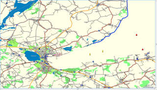
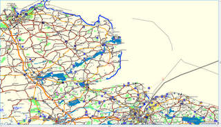
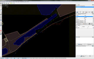
dear developers, i recognized broken coastline errors between the mkgmap verion 1188 and 1398. Please refer to the appended jpegs (my coastline is a little bit thicker ti identify the sea area). Here is the original osm position: http://www.openstreetmap.org/?lat=54.562&lon=9.983&zoom=11&layers=B000FTF You can download all the data from my server: a) version 1188: http://planetearth.informatik.haw-hamburg.de/forMapSource/schleswig-holstein... b) version 1398: http://planetearth.informatik.haw-hamburg.de/error_mkgmap-r1398_forMapSource... c) the build script: http://planetearth.informatik.haw-hamburg.de/scripte/doSchleswigHolstein.bas... d) the build script: http://planetearth.informatik.haw-hamburg.de/error_mkgmap-r1398_forSDcard/sc... It seems, that the error belongs to changes (see last jpeg) in multipolygon behavior of newer mkgmap code. Please check, whether there is a new problem in the code or in the tags from the maps. regards Michael

Michael.TheBlackCat schrieb:
i recognized broken coastline errors between the mkgmap verion 1188 and 1398. Please refer to the appended jpegs (my coastline is a little bit thicker ti identify the sea area).
Hi Michael, I can confirm that this problem exists in the newer versions of mkgmap. Some coastlines are missing in the map. Dunno if this has something to do with the changes in the multipolygon code. On your map http://www.openstreetmap.org/browse/way/38619137 seems to be missing while http://www.openstreetmap.org/browse/way/32230281 is ok. Both having the same tags and beeing member of the same 3 relations. Very strange.... Chris
Chris-Hein Lunkhusen schrieb:
Michael.TheBlackCat schrieb:
i recognized broken coastline errors between the mkgmap verion 1188 and 1398. Please refer to the appended jpegs (my coastline is a little bit thicker ti identify the sea area).
Hi Michael, I can confirm that this problem exists in the newer versions of mkgmap. Some coastlines are missing in the map.
Dunno if this has something to do with the changes in the multipolygon code.
After playing a little bit with the data, I think it is the MP code thats causing the coastline to disappear. It seems that the error occurs, when a coastline is member of to many boundary-multipolygons. In my test the coastline was disappearing when beeing member of more than two boundary-MPs. So as a workaround: I think for boundary-multipolygons the multi-MP handling is not neccecary at all, because boundaries (normally) are rendered as lines and not as areas. Chris
I can confirm that this problem exists in the newer versions of mkgmap. Some coastlines are missing in the map.
After playing a little bit with the data, I think it is the MP code thats causing the coastline to disappear.
It seems that the error occurs, when a coastline is member of to many boundary-multipolygons. In my test the coastline was disappearing when beeing member of more than two boundary-MPs.
So as a workaround: I think for boundary-multipolygons the multi-MP handling is not neccecary at all, because boundaries (normally) are rendered as lines and not as areas.
I hacked a little OSM preprocessor in vb.net (don't speak java) which does the following: change type from multipolygon to boundarypolygon for all MPs with no inner-elements. This eliminates the MP processing for those boundary polygons. If someone want's to get it, -> mail me. Chris
Hi Chris, thanks for your well done work. I tested your script with mkgmap V 1398 and the daily download from http://download.geofabrik.de/osm/europe/germany/schleswig-holstein.osm.bz2 After building, i see the complete coastline as before in version 1188 of mkgmap. Now i don't know what to do in the next step. A nice variant would be a code extension for mkgmap with such behavior. Who of the mean mkgmap developers is able to support such code extension? Or is it a minor functionality/behavior which should never be implemented? cheers Michael Chris-Hein Lunkhusen schrieb:
I can confirm that this problem exists in the newer versions of mkgmap. Some coastlines are missing in the map.
After playing a little bit with the data, I think it is the MP code thats causing the coastline to disappear.
It seems that the error occurs, when a coastline is member of to many boundary-multipolygons. In my test the coastline was disappearing when beeing member of more than two boundary-MPs.
So as a workaround: I think for boundary-multipolygons the multi-MP handling is not neccecary at all, because boundaries (normally) are rendered as lines and not as areas.
I hacked a little OSM preprocessor in vb.net (don't speak java) which does the following:
change type from multipolygon to boundarypolygon for all MPs with no inner-elements. This eliminates the MP processing for those boundary polygons.
If someone want's to get it, -> mail me.
Chris
_______________________________________________ mkgmap-dev mailing list mkgmap-dev@lists.mkgmap.org.uk http://www.mkgmap.org.uk/mailman/listinfo/mkgmap-dev
Chris-Hein Lunkhusen schrieb:
Chris-Hein Lunkhusen schrieb:
Michael.TheBlackCat schrieb:
i recognized broken coastline errors between the mkgmap verion 1188 and 1398. Please refer to the appended jpegs (my coastline is a little bit thicker ti identify the sea area).
Hi Michael, I can confirm that this problem exists in the newer versions of mkgmap. Some coastlines are missing in the map.
Dunno if this has something to do with the changes in the multipolygon code.
After playing a little bit with the data, I think it is the MP code thats causing the coastline to disappear.
It seems that the error occurs, when a coastline is member of to many boundary-multipolygons. In my test the coastline was disappearing when beeing member of more than two boundary-MPs.
So as a workaround: I think for boundary-multipolygons the multi-MP handling is not neccecary at all, because boundaries (normally) are rendered as lines and not as areas.
Chris
Hi Chris, thanks for your help and work. But now, i don't know what make to do. I noticed your last message with the vb script. You can send me the script and i attempt to test it with the latest version of mkgmap, but i use a linux-server for rendering, i hope, it works out. My email address is: Michael.TheBlackCat@googlemail.com Cheers, Michael
_______________________________________________ mkgmap-dev mailing list mkgmap-dev@lists.mkgmap.org.uk http://www.mkgmap.org.uk/mailman/listinfo/mkgmap-dev
participants (2)
-
 Chris-Hein Lunkhusen
 -
 Michael.TheBlackCat