routing error example

Hi, I have made a cut down sample map showing an error in routing as displayed in mapsource. The source is in polish format, and includes the junction where the errors are found, and a portion of a city to the south. If I delete more roads from the city, the error disappears, even though the error itself is apparently north of the city. The routing works correctly in gpsmapedit. The graphic file shows the junction where the errors are happening. The route should be west and south from one waypoint to the other, and instead it jumps about, sometimes following roads, sometimes making straight-line jumps. In another post, I was told there are “short arcs” errors in the polish format input. Could somebody describe exactly what a short arc is, (length between nodes, length between routing nodes or something else, and what is the minimum length arc)? gpsmapedit reports that all nodes are greater than 5m apart in the input. Thanks for any suggestions, Garvan

Hi Garvan,
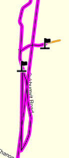
I have made a cut down sample map showing an error in routing as displayed in mapsource. The source is in polish format, and includes the junction where the errors are found, and a portion of a city to the south. If I delete more roads from the city, the error disappears, even though the error itself is apparently north of the city. The routing works correctly in gpsmapedit.
The graphic file shows the junction where the errors are happening. The route should be west and south from one waypoint to the other, and instead it jumps about, sometimes following roads, sometimes making straight-line jumps.
I can't find the point on the map the graphic is showing. What are the coordinates of the junction between the two flags?
In another post, I was told there are “short arcs” errors in the polish format input. Could somebody describe exactly what a short arc is, (length between nodes, length between routing nodes or something else, and what is the minimum length arc)?
A short arc is where two routing nodes are so close together that they are located at the same point. The minimum distance between routing nodes is approx 2.5 metres.
gpsmapedit reports that all nodes are greater than 5m apart in the input.
Good, then it's probably not short arcs that are the issue here. Cheers, Mark
Quoting Mark Burton <markb@ordern.com>:
Hi Garvan,
I have made a cut down sample map showing an error in routing as displayed in mapsource. The source is in polish format, and includes the junction where the errors are found, and a portion of a city to the south. If I delete more roads from the city, the error disappears, even though the error itself is apparently north of the city. The routing works correctly in gpsmapedit.
The graphic file shows the junction where the errors are happening. The route should be west and south from one waypoint to the other, and instead it jumps about, sometimes following roads, sometimes making straight-line jumps.
I can't find the point on the map the graphic is showing. What are the coordinates of the junction between the two flags?
Sorry , the junction is near N13.10330 E100.91647 Garvan
garvan.maew@online.com.kh wrote:
Quoting Mark Burton <markb@ordern.com>:
Hi Garvan,
I have made a cut down sample map showing an error in routing as displayed in mapsource. The source is in polish format, and includes the junction where the errors are found, and a portion of a city to the south. If I delete more roads from the city, the error disappears, even though the error itself is apparently north of the city. The routing works correctly in gpsmapedit.
The graphic file shows the junction where the errors are happening. The route should be west and south from one waypoint to the other, and instead it jumps about, sometimes following roads, sometimes making straight-line jumps.
I can't find the point on the map the graphic is showing. What are the coordinates of the junction between the two flags?
Sorry , the junction is near
N13.10330 E100.91647
Garvan
_______________________________________________ mkgmap-dev mailing list mkgmap-dev@lists.mkgmap.org.uk http://www.mkgmap.org.uk/mailman/listinfo/mkgmap-dev
I converted the polish format file to osm format, and I still get the same problem. However it look s like I can work around it by splitting long roads (it worked in my small test file)? I will keep testing. Garvan
participants (3)
-
 Garvan & maew
 -
garvan.maew@online.com.kh
-
 Mark Burton