Commit: r1449: Provide an alternative to using a multipolygon when generating the sea.

Version 1449 was commited by markb on 2009-12-31 12:00:01 +0000 (Thu, 31 Dec 2009) Provide an alternative to using a multipolygon when generating the sea. The --generate-sea option can now take a comma separated list of values: multipolygon - generate the sea using a multipolygon (the default behaviour so this really doesn't need to be specified). polygons | no-mp - don't generate the sea using a multipolygon - instead, generate a background sea polygon plus individual land polygons with tag natural=land. This requires a suitable land polygon type to be defined in the style file (suggested type is 0x010100) and the polygon must be defined in the TYP file as having a higher drawing level than the sea polygon type. no-sea-sectors - disable the generation of "sea sectors" when the coastline fails to reach the tile's boundary. An unrecognised option value or the value "help" will cause some help blurb to be printed. For backwards compatibility, with no values specified, the --generate-sea option should behave as it did before.

On 31.12.2009 13:00, svn commit wrote:
Version 1449 was commited by markb on 2009-12-31 12:00:01 +0000 (Thu, 31 Dec 2009)
Provide an alternative to using a multipolygon when generating the sea.
The --generate-sea option can now take a comma separated list of values:
multipolygon - generate the sea using a multipolygon (the default behaviour so this really doesn't need to be specified).
polygons | no-mp - don't generate the sea using a multipolygon - instead, generate a background sea polygon plus individual land polygons with tag natural=land. This requires a suitable land polygon type to be defined in the style file (suggested type is 0x010100) and the polygon must be defined in the TYP file as having a higher drawing level than the sea polygon type.
no-sea-sectors - disable the generation of "sea sectors" when the coastline fails to reach the tile's boundary.
An unrecognised option value or the value "help" will cause some help blurb to be printed.
For backwards compatibility, with no values specified, the --generate-sea option should behave as it did before. _______________________________________________ mkgmap-dev mailing list mkgmap-dev@lists.mkgmap.org.uk http://www.mkgmap.org.uk/mailman/listinfo/mkgmap-dev
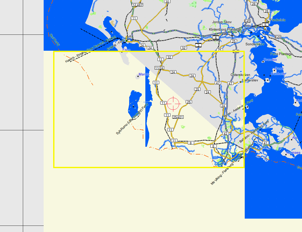
Even though I do think that this is similar to v3 patch I'll answer here. I just tried compiling Denmark from geofabrik to see how well this new --generate-sea=polygons works. It worked in 12/13 tiles. See below the broken tile where no 0x10f1d polygon for the sea (as defined in polygons file) got created at all, furthermore 1 island is flooded (in the center of the tile). I used grey as backround color so one can easily spot mistakes.

Hi Felix,
It worked in 12/13 tiles. See below the broken tile where no 0x10f1d polygon for the sea (as defined in polygons file) got created at all, furthermore 1 island is flooded (in the center of the tile). I used grey as backround color so one can easily spot mistakes.
From my meagre understanding of how the sea poly generation works, I think you will always have issues if the coastline doesn't reach the tile boundary (for non-islands). Your example shows the coastline stopping short of the tile boundary, so it's not going to work. I can't see how the sea poly generation code can work around this - it's not psychic. Cheers, Mark
PS - try no-sea-sectors - e.g. --generate-sea=polygons,no-sea-sectors
On 31.12.2009 15:28, Mark Burton wrote:
PS - try no-sea-sectors - e.g. --generate-sea=polygons,no-sea-sectors
Well if I use that option then I get the whole tile flooded. The good thing is, the --generate-sea option only adds about 7-8% of generation time. So it is not so slow anymore.
_______________________________________________ mkgmap-dev mailing list mkgmap-dev@lists.mkgmap.org.uk http://www.mkgmap.org.uk/mailman/listinfo/mkgmap-dev
Felix,
PS - try no-sea-sectors - e.g. --generate-sea=polygons,no-sea-sectors
Well if I use that option then I get the whole tile flooded.
As I said before: "If you don't clip the coast, expect toast!"
The good thing is, the --generate-sea option only adds about 7-8% of generation time. So it is not so slow anymore.
Yes, that's a nice side effect of using this method of sea generation. Mark
On 31.12.2009 15:43, Mark Burton wrote:
Felix,
PS - try no-sea-sectors - e.g. --generate-sea=polygons,no-sea-sectors
Well if I use that option then I get the whole tile flooded.
As I said before: "If you don't clip the coast, expect toast!"
The good thing is, the --generate-sea option only adds about 7-8% of generation time. So it is not so slow anymore.
Yes, that's a nice side effect of using this method of sea generation.
Okay, so manual coastlines are probably still needed except for very large extracts or islands. BTW it would be better to have mkgmap=land or similar, instead of natural=land because natural=land does exist and is used. I would prefer to have a different color for real natural=land vs mkgmap land background.
Mark _______________________________________________ mkgmap-dev mailing list mkgmap-dev@lists.mkgmap.org.uk http://www.mkgmap.org.uk/mailman/listinfo/mkgmap-dev
Felix,
Okay, so manual coastlines are probably still needed except for very large extracts or islands.
Don't know what you mean by "manual coastlines" - the whole map is "manual", isn't it?
BTW it would be better to have mkgmap=land or similar, instead of natural=land because natural=land does exist and is used. I would prefer to have a different color for real natural=land vs mkgmap land background.
Well, according to the wiki (I know, who gives a flying fuck about the wiki) it says about natural=land: "Land that exists within another area, such as a lake. (i.e an island)." Spot on, I'd say. No one in their right mind would think that natural=land wasn't appropriate for island and other land masses. So I prefer to keep the default as natural=land. I like it. But just for you Felix, I have put in an option so you can specify the tag to use. Be creative. Mark
participants (3)
-
 Felix Hartmann
 -
 Mark Burton
 -
 svn commit