
Hello, I use the following line in my points style file : natural=peak {name '${name}'} [0x661d resolution 20] I have the appropriate 0x661d icon in my .TYP file. The icon is well displayed on my Garmin, but not the name of the peak. The osm file has the right information in it : <node id="423283143" lat="45.1969885" lon="3.724827" version="3" changeset="1631916" user="persei" uid="117980" visible="true" timestamp="2009-06-26T04:57:46Z"> <tag k="name" v="Mont Bar"/> <tag k="natural" v="peak"/> <tag k="ele" v="1168"/> </node> I thought the name of that peak would have been displayed on the map. Is it right ? I use a Garmin Oregon 400T Second question : Is it possible to have the elevation displayed on the map too ? What do I have to write in my points file to succeed ? Something like : natural=peak { name '${name} ${ele}' | '${name}' | '${ele}' } [0x661d resolution 20] ?? Thank you. Francois --

0> In article <4A464D60.6090707@free.fr>, 0> frmas <URL:mailto:frmas@free.fr> ("Frmas") wrote: Frmas> I use the following line in my points style file : Frmas> natural=peak {name '${name}'} [0x661d resolution 20] Frmas> Frmas> I have the appropriate 0x661d icon in my .TYP file. Frmas> Frmas> The icon is well displayed on my Garmin, but not the name of the Frmas> peak. Works for me on my ETrex (though I use the builtin TYP of 0x6616). Have you double-checked that your TYP file has the appropriate label attributes? Do you get the name when you select the peak on the device? Frmas> Second question : Is it possible to have the elevation displayed Frmas> on the map too ? What do I have to write in my points file to Frmas> succeed ? Something like : Frmas> Frmas> natural=peak { name '${name} ${ele}' | '${name}' | '${ele}' } Frmas> [0x661d resolution 20] Find the patch I submitted a couple of months ago (in the list archive - I think it's called the "highway symbols" patch); with that patch applied, then my 'points' style looks like /-------- | natural=peak {name '${name|def:}${ele|height:m=>ft|def:}' } [0x6616 resolution 18] \-------- Without the patch, then what you have written is the next best thing (but won't take account of changing the height units in your device's settings).
Toby Speight a écrit :
Frmas> The icon is well displayed on my Garmin, but not the name of the Frmas> peak.
Works for me on my ETrex (though I use the builtin TYP of 0x6616). Have you double-checked that your TYP file has the appropriate label attributes?
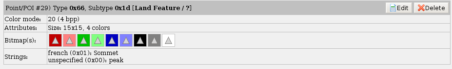
Hmm, this is what that entry looks like. See file attached
Do you get the name when you select the peak on the device?
Yes, one click on the peak gives me its name.
Frmas> Second question : Is it possible to have the elevation displayed Frmas> on the map too ? What do I have to write in my points file to Frmas> succeed ? Something like : Frmas> Frmas> natural=peak { name '${name} ${ele}' | '${name}' | '${ele}' } Frmas> [0x661d resolution 20]
Find the patch I submitted a couple of months ago (in the list archive - I
OK, thank you. I'm gonna look at it. Could have been useful to commit it no? Francois
participants (2)
-
 frmas
frmas -
 Toby Speight