
Hi all, does anyone have an idea, why osmconvert64 seems to do not work anymore ? I have used this to build bounds files on my one (if the input file ist small enough) but today with a fresh loaded pbf file from "http://download.geofabrik.de/" this line "c:\Program Files (x86)\KartenTools\osmconvert64.exe" .\input\nordrhein-westfalen-latest.osm.pbf -o=.\input\nordrhein-westfalen-latest.o5m only produces an empty output ? Did i miss something ? Some month ago it was working .... -- Mit freundlichen Grüßen ##################################################### Manfred Haiduk, Zum Fischbach 9, 52393 Hürtgenwald e-mail mhaiduk@t-online.de #####################################################

Hi Manfred, I don't see those problems with osmcovert 0.8.6, curent version is 0.8.8. Maybe you use an older version which cannot cope with the reduced meta data? See also the text in the green box at http://download.geofabrik.de/europe/germany/nordrhein-westfalen.html Gerd ________________________________________ Von: mkgmap-dev <mkgmap-dev-bounces@lists.mkgmap.org.uk> im Auftrag von Manfred Haiduk <mhaiduk@t-online.de> Gesendet: Dienstag, 15. Mai 2018 23:28:21 An: Development list for mkgmap Betreff: [mkgmap-dev] osmconvert64 Hi all, does anyone have an idea, why osmconvert64 seems to do not work anymore ? I have used this to build bounds files on my one (if the input file ist small enough) but today with a fresh loaded pbf file from "http://download.geofabrik.de/" this line "c:\Program Files (x86)\KartenTools\osmconvert64.exe" .\input\nordrhein-westfalen-latest.osm.pbf -o=.\input\nordrhein-westfalen-latest.o5m only produces an empty output ? Did i miss something ? Some month ago it was working .... -- Mit freundlichen Grüßen ##################################################### Manfred Haiduk, Zum Fischbach 9, 52393 Hürtgenwald e-mail mhaiduk@t-online.de ##################################################### _______________________________________________ mkgmap-dev mailing list mkgmap-dev@lists.mkgmap.org.uk http://www.mkgmap.org.uk/mailman/listinfo/mkgmap-dev
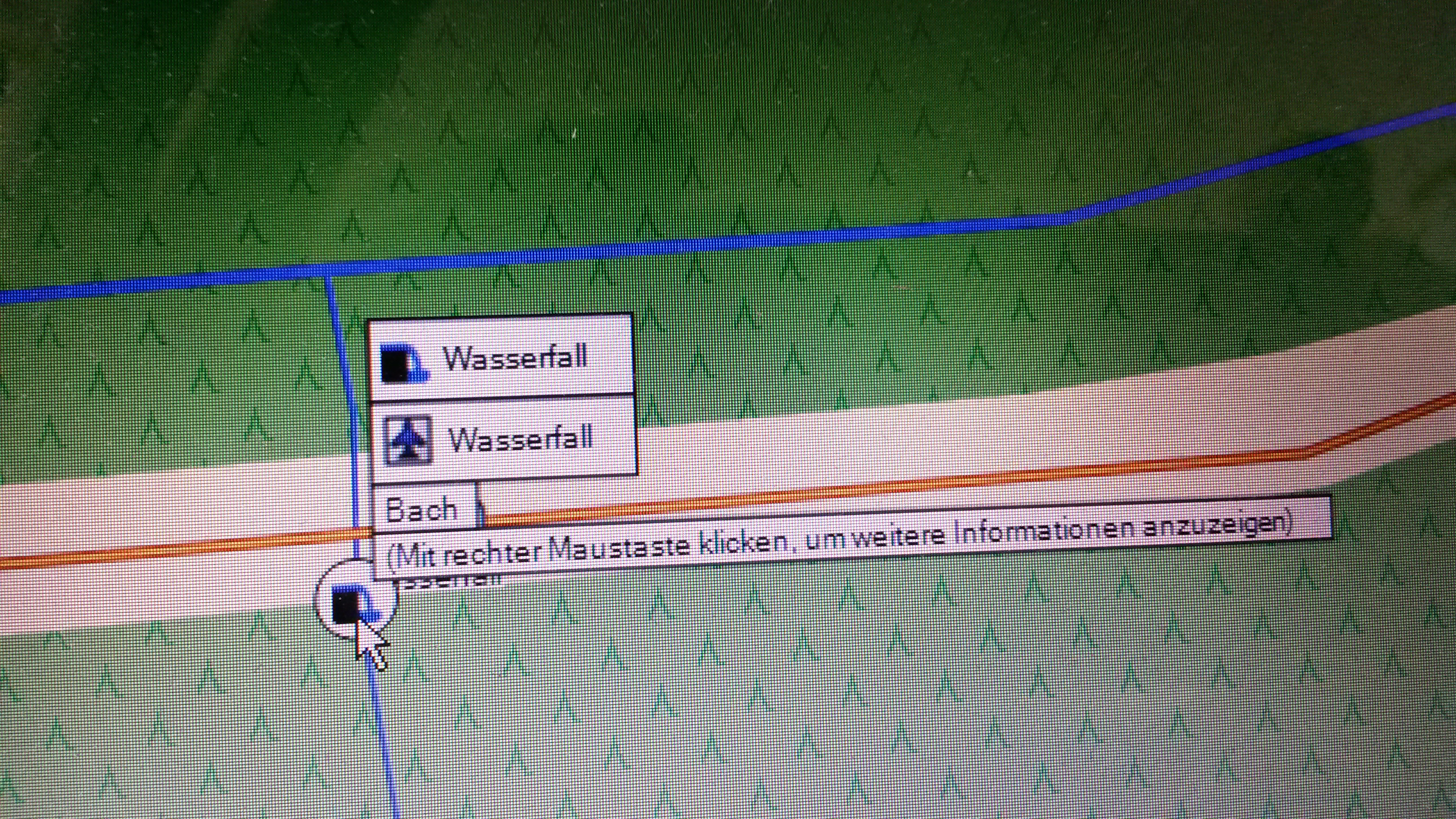
Thank you for the answer, sometimes it's worth to do an update :-). I've played again with my map creation because i discovered a new phenomenom (only at map source or base camp, not on my GPSMAP276Cx). At the attached picture you see two icons at the place of a waterfall, the right one and curiosly an aircraft symbol. To find out whats happening, i deleted the aircraft symbol from my style and all requests in the style files to disply this icon. But mapsource and base camp do still display the wrong aircraft icon.Any thoughts, where i can search ? Am 16.05.2018 um 07:10 schrieb Gerd Petermann:
Hi Manfred,
I don't see those problems with osmcovert 0.8.6, curent version is 0.8.8. Maybe you use an older version which cannot cope with the reduced meta data? See also the text in the green box at http://download.geofabrik.de/europe/germany/nordrhein-westfalen.html
Gerd
________________________________________ Von: mkgmap-dev <mkgmap-dev-bounces@lists.mkgmap.org.uk> im Auftrag von Manfred Haiduk <mhaiduk@t-online.de> Gesendet: Dienstag, 15. Mai 2018 23:28:21 An: Development list for mkgmap Betreff: [mkgmap-dev] osmconvert64
Hi all,
does anyone have an idea, why osmconvert64 seems to do not work anymore ? I have used this to build bounds files on my one (if the input file ist small enough) but today with a fresh loaded pbf file from "http://download.geofabrik.de/" this line
"c:\Program Files (x86)\KartenTools\osmconvert64.exe" .\input\nordrhein-westfalen-latest.osm.pbf -o=.\input\nordrhein-westfalen-latest.o5m
only produces an empty output ? Did i miss something ? Some month ago it was working ....
--
Mit freundlichen Grüßen
##################################################### Manfred Haiduk, Zum Fischbach 9, 52393 Hürtgenwald e-mail mhaiduk@t-online.de #####################################################
_______________________________________________ mkgmap-dev mailing list mkgmap-dev@lists.mkgmap.org.uk http://www.mkgmap.org.uk/mailman/listinfo/mkgmap-dev
-- Mit freundlichen Grüßen ##################################################### Manfred Haiduk, Zum Fischbach 9, 52393 Hürtgenwald e-mail mhaiduk@t-online.de #####################################################

El 17/05/18 a las 14:35, Manfred Haiduk escribió:
I've played again with my map creation because i discovered a new phenomenom (only at map source or base camp, not on my GPSMAP276Cx). At the attached picture you see two icons at the place of a waterfall, the right one and curiosly an aircraft symbol. To find out whats happening, i deleted the aircraft symbol from my style and all requests in the style files to disply this icon. But mapsource and base camp do still display the wrong aircraft icon.Any thoughts, where i can search ? I'm suffering a similar problem since a couple of months or more. Estrange icons are displayed on MapSource, even icons I do not have in my TYP. I thought it could be related to using MapSource under wine on Linux, but now I see I'm not the only one with this issue

I am also having troubles with OSMCONVERT64 (latest version 0.8.8). When converting Belgium-latest.osm.pdf ( 2018-05-17) with osmconvert64 to *.o5m, no styles, mkgmap-r4191, I get a lot of straight lines crossing (roads?) all over the map. Using OSMconvert (32-bit), there are no problems. I also tried it with Luxembourg, and here no problems with osmconvert64. Guy -- Sent from: http://gis.19327.n8.nabble.com/Mkgmap-Development-f5324443.html
Latest Belgium-latest.osm.pbf seems to work now with osmconvert64. Guy -- Sent from: http://gis.19327.n8.nabble.com/Mkgmap-Development-f5324443.html
participants (4)
-
 Carlos Dávila
 -
 Gerd Petermann
 -
 Guy
Guy -
 Manfred Haiduk