
One user of my maps reports that his Etrex 30 displays Spain topo map [1] with a black background instead of white as it should be according to the TYP. Could someone with an Etrex 30 test the map and confirm that behavior? May it be another peculiarity of this model? Map is generated with the following commands: *OSM base map: mkgmap.jar --output-dir=../mapas/españa --max-jobs --generate-sea=multipolygon,extend-sea-sectors --route --latin1 --code-page=1252 --tdbfile --country-name=ESPAÑA --country-abbr=ESP --area-name=España --family-name="OpenStreetMap España" --family-id=14 --product-id=1 --series-name="OSM-España" --overview-mapname=55140000 --overview-mapnumber=55140000 --index --road-name-pois=0x640a --ignore-maxspeeds --remove-short-arcs --merge-lines --add-pois-to-areas --adjust-turn-headings --report-similar-arcs --link-pois-to-ways --location-autofill=bounds,is_in --drive-on-right --check-roundabouts --check-roundabout-flares --style=mio -c spain.args *Contour tiles: mkgmap.jar --output-dir=../mapas/curvas/ --family-id=214 --product-id=1 --family-name="Curvas nivel España" --series-name="SRTM España" --tdbfile --overview-mapname=65140000 --transparent --draw-priority=28 --code-page=1252 --latin1 6514*.pbf *Join OSM+contours: mkgmap.jar --family-id=114 --product-id=1 --family-name="Curvas nivel España" 651400*.img --show-profiles=1 --gmapsupp --code-page=1252 --latin1 --series-name="OSM+SRTM España" --family-id=314 --product-id=1 --family-name="OpenStreetMap España" --description="OpenStreetMap-España" --area-name="España" --index --overview-mapname=65140000 5514*.img ESP-314.TYP [1] http://mapas.alternativaslibres.es/gmapsupp_spain_srtm.zip
El 11/04/12 11:45, Minko escribió:
David, could be the night display that is turned on?
No, I already thought about that, but the reporter says other maps from [1] look ok. If night mode were on it would affect all maps, wouldn't it? [1] http://www.gpsfiledepot.com/maps/state/all
El 11/04/12 13:19, Carlos Dávila escribió:
El 11/04/12 11:45, Minko escribió:
David, could be the night display that is turned on?
No, I already thought about that, but the reporter says other maps from [1] look ok. If night mode were on it would affect all maps, wouldn't it?
Well, that's supposing those other maps have a different background for day and night mode. I'll ask reporter to check it again.
[1] http://www.gpsfiledepot.com/maps/state/all _______________________________________________ mkgmap-dev mailing list mkgmap-dev@lists.mkgmap.org.uk http://www.mkgmap.org.uk/mailman/listinfo/mkgmap-dev
-- Por favor, no me envíe documentos con extensiones .doc, .docx, .xls, .xlsx, .ppt, .pptx, .mdb, mdbx Instale LibreOffice desde http://es.libreoffice.org/descarga/ LibreOffice es libre: se puede copiar, modificar y redistribuir libremente. Gratis y totalmente legal. LibreOffice está en continuo desarrollo y no tendrá que pagar por las nuevas versiones.
El 11/04/12 13:32, Carlos Dávila escribió:
El 11/04/12 13:19, Carlos Dávila escribió:
El 11/04/12 11:45, Minko escribió:
David, could be the night display that is turned on?
No, I already thought about that, but the reporter says other maps from [1] look ok. If night mode were on it would affect all maps, wouldn't it?
Well, that's supposing those other maps have a different background for day and night mode. I'll ask reporter to check it again.
Both auto and daylight modes show black background :-(

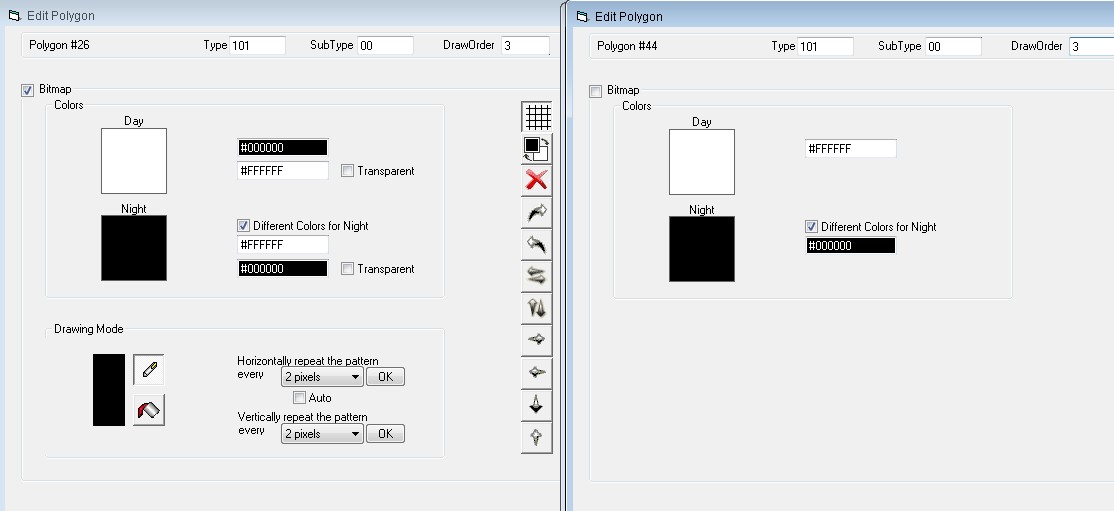
Carlos, Maybe you can try to change the background in your typ file into this: [_polygon] Type=0x10100 String1=0x08,Terreno String2=0x04,Land String3=0x02,Land String4=0x01,Terrain ExtendedLabels=N Xpm="0 0 2 0" "1 c #FFFFFF" "2 c #000000" [end] See attachment (Typviewer screenshot). Left is yours, right is something like my maps (no problems reported with etrex 30 users)
El 11/04/12 18:34, Minko escribió:
Carlos, Maybe you can try to change the background in your typ file into this:
[_polygon] Type=0x10100 String1=0x08,Terreno String2=0x04,Land String3=0x02,Land String4=0x01,Terrain ExtendedLabels=N Xpm="0 0 2 0" "1 c #FFFFFF" "2 c #000000" [end]
See attachment (Typviewer screenshot). Left is yours, right is something like my maps (no problems reported with etrex 30 users) Seems quite reasonable, in fact I don't know why I was using a bitmap for background. I'll try it and report.

I don't know why I was using a bitmap for background.
Because you will not succeed in changing the yellow background colour on the older eTrex series (Legend etc.), unless you use a bitmap. See http://www.mkgmap.org.uk/pipermail/mkgmap-dev/2010q1/006929.html
My example works for the older Etrex (white background) as well. Adrain wrote: Because you will not succeed in changing the yellow background colour on the older eTrex series (Legend etc.), unless you use a bitmap. See http://www.mkgmap.org.uk/pipermail/mkgmap-dev/2010q1/006929.html
El 11/04/12 19:10, Carlos Dávila escribió:
El 11/04/12 18:34, Minko escribió:
Carlos, Maybe you can try to change the background in your typ file into this:
[_polygon] Type=0x10100 String1=0x08,Terreno String2=0x04,Land String3=0x02,Land String4=0x01,Terrain ExtendedLabels=N Xpm="0 0 2 0" "1 c #FFFFFF" "2 c #000000" [end]
See attachment (Typviewer screenshot). Left is yours, right is something like my maps (no problems reported with etrex 30 users)
Seems quite reasonable, in fact I don't know why I was using a bitmap for background. I'll try it and report. It seems it didn't work either :-( . Any Etrex 30 owner out there tried it?
participants (3)
-
 Adrian
 -
 Carlos Dávila
 -
 Minko
Minko