gaps in road and other issues with r3875

Hi, Users of my OFM map have reported gaps in the roads (mainly non routable lines used for highways that are forbidden for cyclists). I've found out this is worse in the latest mkgmap releases 3875, 3880. See the screenshot, the location is https://www.openstreetmap.org/?mlat=51.59253&mlon=5.33765#map=19/51.59253/5.... I have also compiled it with r3847, no gaps. There are other issues. With the default style I cannot even get a working map from the osm file. Something with the overview map is blocking it all? Really strange, if I open the img with gpsmapedit I can see it contains all the data, so something must be wrong with the index or overview files too. I have found out it makes sense if I leave the %typfile% option out or not (see java command below). With no typefile specified, mkgmap r3875 does not show a map. With some typfile behind %argsfile%, everything works as expected (default style does not show a gap). I also noticed this mkgmap version crashed on the license file, something has changed there too? It contained a ©mark. Only after replacing it with (c) mkgmap could finish the job. java -Xmx4000m -jar %MKGMAP% --product-version=%version% --output-dir=%date% --family-id=%FID% --overview-mapname=OFM_%mapname% --series-name="OFM (%mapname%v%date%)" --family-name="OFM (%mapname%)" --area-name="OFM_%mapname%(%date%)" -c %argsfile% %typfile%

Hi Minko, most changes since r3487 were for the index, 3877 fixed a routing problem. No change regarding RGN or handling of license file, esp. no change that would explain the gap. Don't know how to reproduce that problem. Is it related to OSM data or only to options / contents of other input files ? Please provide a link to a small set of input files + script and let me know what you expect and what you get. Gerd ________________________________________ Von: mkgmap-dev <mkgmap-dev-bounces@lists.mkgmap.org.uk> im Auftrag von lig fietser <ligfietser@hotmail.com> Gesendet: Sonntag, 9. April 2017 10:07:49 An: mkgmap-dev Betreff: [mkgmap-dev] gaps in road and other issues with r3875 Hi, Users of my OFM map have reported gaps in the roads (mainly non routable lines used for highways that are forbidden for cyclists). I've found out this is worse in the latest mkgmap releases 3875, 3880. See the screenshot, the location is https://www.openstreetmap.org/?mlat=51.59253&mlon=5.33765#map=19/51.59253/5.... I have also compiled it with r3847, no gaps. There are other issues. With the default style I cannot even get a working map from the osm file. Something with the overview map is blocking it all? Really strange, if I open the img with gpsmapedit I can see it contains all the data, so something must be wrong with the index or overview files too. I have found out it makes sense if I leave the %typfile% option out or not (see java command below). With no typefile specified, mkgmap r3875 does not show a map. With some typfile behind %argsfile%, everything works as expected (default style does not show a gap). I also noticed this mkgmap version crashed on the license file, something has changed there too? It contained a ©mark. Only after replacing it with (c) mkgmap could finish the job. java -Xmx4000m -jar %MKGMAP% --product-version=%version% --output-dir=%date% --family-id=%FID% --overview-mapname=OFM_%mapname% --series-name="OFM (%mapname%v%date%)" --family-name="OFM (%mapname%)" --area-name="OFM_%mapname%(%date%)" -c %argsfile% %typfile%
Hi Minko, okay, tried with that small area and no options beside --nsis and yes, MapSource doesn't show a map. With older version it works. No idea why, I have to compare the img files. Gerd ________________________________________ Von: mkgmap-dev <mkgmap-dev-bounces@lists.mkgmap.org.uk> im Auftrag von Gerd Petermann <GPetermann_muenchen@hotmail.com> Gesendet: Sonntag, 9. April 2017 10:36:55 An: Development list for mkgmap Betreff: Re: [mkgmap-dev] gaps in road and other issues with r3875 Hi Minko, most changes since r3487 were for the index, 3877 fixed a routing problem. No change regarding RGN or handling of license file, esp. no change that would explain the gap. Don't know how to reproduce that problem. Is it related to OSM data or only to options / contents of other input files ? Please provide a link to a small set of input files + script and let me know what you expect and what you get. Gerd ________________________________________ Von: mkgmap-dev <mkgmap-dev-bounces@lists.mkgmap.org.uk> im Auftrag von lig fietser <ligfietser@hotmail.com> Gesendet: Sonntag, 9. April 2017 10:07:49 An: mkgmap-dev Betreff: [mkgmap-dev] gaps in road and other issues with r3875 Hi, Users of my OFM map have reported gaps in the roads (mainly non routable lines used for highways that are forbidden for cyclists). I've found out this is worse in the latest mkgmap releases 3875, 3880. See the screenshot, the location is https://www.openstreetmap.org/?mlat=51.59253&mlon=5.33765#map=19/51.59253/5.... I have also compiled it with r3847, no gaps. There are other issues. With the default style I cannot even get a working map from the osm file. Something with the overview map is blocking it all? Really strange, if I open the img with gpsmapedit I can see it contains all the data, so something must be wrong with the index or overview files too. I have found out it makes sense if I leave the %typfile% option out or not (see java command below). With no typefile specified, mkgmap r3875 does not show a map. With some typfile behind %argsfile%, everything works as expected (default style does not show a gap). I also noticed this mkgmap version crashed on the license file, something has changed there too? It contained a ©mark. Only after replacing it with (c) mkgmap could finish the job. java -Xmx4000m -jar %MKGMAP% --product-version=%version% --output-dir=%date% --family-id=%FID% --overview-mapname=OFM_%mapname% --series-name="OFM (%mapname%v%date%)" --family-name="OFM (%mapname%)" --area-name="OFM_%mapname%(%date%)" -c %argsfile% %typfile% _______________________________________________ mkgmap-dev mailing list mkgmap-dev@lists.mkgmap.org.uk http://www.mkgmap.org.uk/mailman/listinfo/mkgmap-dev
Hi Gerd, First a minor problem, license2.txt crashes with 3880 but not with mkgmap-r3660, (3847 crashes too) Error reading license file licentie2.txt java.nio.charset.MalformedInputException: Input length = 1 In my args file I have license-file: licentie2.txt It has nothing to do with the gaps. ________________________________ Van: mkgmap-dev <mkgmap-dev-bounces@lists.mkgmap.org.uk> namens Gerd Petermann <GPetermann_muenchen@hotmail.com> Verzonden: zondag 9 april 2017 01:36:55 Aan: Development list for mkgmap Onderwerp: Re: [mkgmap-dev] gaps in road and other issues with r3875 Hi Minko, most changes since r3487 were for the index, 3877 fixed a routing problem. No change regarding RGN or handling of license file, esp. no change that would explain the gap. Don't know how to reproduce that problem. Is it related to OSM data or only to options / contents of other input files ? Please provide a link to a small set of input files + script and let me know what you expect and what you get. Gerd ________________________________________ Von: mkgmap-dev <mkgmap-dev-bounces@lists.mkgmap.org.uk> im Auftrag von lig fietser <ligfietser@hotmail.com> Gesendet: Sonntag, 9. April 2017 10:07:49 An: mkgmap-dev Betreff: [mkgmap-dev] gaps in road and other issues with r3875 Hi, Users of my OFM map have reported gaps in the roads (mainly non routable lines used for highways that are forbidden for cyclists). I've found out this is worse in the latest mkgmap releases 3875, 3880. See the screenshot, the location is https://www.openstreetmap.org/?mlat=51.59253&mlon=5.33765#map=19/51.59253/5.... I have also compiled it with r3847, no gaps. There are other issues. With the default style I cannot even get a working map from the osm file. Something with the overview map is blocking it all? Really strange, if I open the img with gpsmapedit I can see it contains all the data, so something must be wrong with the index or overview files too. I have found out it makes sense if I leave the %typfile% option out or not (see java command below). With no typefile specified, mkgmap r3875 does not show a map. With some typfile behind %argsfile%, everything works as expected (default style does not show a gap). I also noticed this mkgmap version crashed on the license file, something has changed there too? It contained a ©mark. Only after replacing it with (c) mkgmap could finish the job. java -Xmx4000m -jar %MKGMAP% --product-version=%version% --output-dir=%date% --family-id=%FID% --overview-mapname=OFM_%mapname% --series-name="OFM (%mapname%v%date%)" --family-name="OFM (%mapname%)" --area-name="OFM_%mapname%(%date%)" -c %argsfile% %typfile% _______________________________________________ mkgmap-dev mailing list mkgmap-dev@lists.mkgmap.org.uk http://www.mkgmap.org.uk/mailman/listinfo/mkgmap-dev
Hi Minko, okay, that is probably a problem of utf8 enocoding. Your file is not utf8. Gerd ________________________________________ Von: mkgmap-dev <mkgmap-dev-bounces@lists.mkgmap.org.uk> im Auftrag von lig fietser <ligfietser@hotmail.com> Gesendet: Sonntag, 9. April 2017 11:08:30 An: Development list for mkgmap Betreff: Re: [mkgmap-dev] gaps in road and other issues with r3875 Hi Gerd, First a minor problem, license2.txt crashes with 3880 but not with mkgmap-r3660, (3847 crashes too) Error reading license file licentie2.txt java.nio.charset.MalformedInputException: Input length = 1 In my args file I have license-file: licentie2.txt It has nothing to do with the gaps. ________________________________ Van: mkgmap-dev <mkgmap-dev-bounces@lists.mkgmap.org.uk> namens Gerd Petermann <GPetermann_muenchen@hotmail.com> Verzonden: zondag 9 april 2017 01:36:55 Aan: Development list for mkgmap Onderwerp: Re: [mkgmap-dev] gaps in road and other issues with r3875 Hi Minko, most changes since r3487 were for the index, 3877 fixed a routing problem. No change regarding RGN or handling of license file, esp. no change that would explain the gap. Don't know how to reproduce that problem. Is it related to OSM data or only to options / contents of other input files ? Please provide a link to a small set of input files + script and let me know what you expect and what you get. Gerd ________________________________________ Von: mkgmap-dev <mkgmap-dev-bounces@lists.mkgmap.org.uk> im Auftrag von lig fietser <ligfietser@hotmail.com> Gesendet: Sonntag, 9. April 2017 10:07:49 An: mkgmap-dev Betreff: [mkgmap-dev] gaps in road and other issues with r3875 Hi, Users of my OFM map have reported gaps in the roads (mainly non routable lines used for highways that are forbidden for cyclists). I've found out this is worse in the latest mkgmap releases 3875, 3880. See the screenshot, the location is https://www.openstreetmap.org/?mlat=51.59253&mlon=5.33765#map=19/51.59253/5.... I have also compiled it with r3847, no gaps. There are other issues. With the default style I cannot even get a working map from the osm file. Something with the overview map is blocking it all? Really strange, if I open the img with gpsmapedit I can see it contains all the data, so something must be wrong with the index or overview files too. I have found out it makes sense if I leave the %typfile% option out or not (see java command below). With no typefile specified, mkgmap r3875 does not show a map. With some typfile behind %argsfile%, everything works as expected (default style does not show a gap). I also noticed this mkgmap version crashed on the license file, something has changed there too? It contained a ©mark. Only after replacing it with (c) mkgmap could finish the job. java -Xmx4000m -jar %MKGMAP% --product-version=%version% --output-dir=%date% --family-id=%FID% --overview-mapname=OFM_%mapname% --series-name="OFM (%mapname%v%date%)" --family-name="OFM (%mapname%)" --area-name="OFM_%mapname%(%date%)" -c %argsfile% %typfile% _______________________________________________ mkgmap-dev mailing list mkgmap-dev@lists.mkgmap.org.uk http://www.mkgmap.org.uk/mailman/listinfo/mkgmap-dev
Thanks, encoded it with UTF8 and it is now working, r3660 accepted ANSI coding but later releases not anymore? ________________________________ Van: mkgmap-dev <mkgmap-dev-bounces@lists.mkgmap.org.uk> namens Gerd Petermann <GPetermann_muenchen@hotmail.com> Verzonden: zondag 9 april 2017 02:13:47 Aan: Development list for mkgmap Onderwerp: Re: [mkgmap-dev] gaps in road and other issues with r3875 Hi Minko, okay, that is probably a problem of utf8 enocoding. Your file is not utf8. Gerd ________________________________________ Von: mkgmap-dev <mkgmap-dev-bounces@lists.mkgmap.org.uk> im Auftrag von lig fietser <ligfietser@hotmail.com> Gesendet: Sonntag, 9. April 2017 11:08:30 An: Development list for mkgmap Betreff: Re: [mkgmap-dev] gaps in road and other issues with r3875 Hi Gerd, First a minor problem, license2.txt crashes with 3880 but not with mkgmap-r3660, (3847 crashes too) Error reading license file licentie2.txt java.nio.charset.MalformedInputException: Input length = 1 In my args file I have license-file: licentie2.txt It has nothing to do with the gaps. ________________________________ Van: mkgmap-dev <mkgmap-dev-bounces@lists.mkgmap.org.uk> namens Gerd Petermann <GPetermann_muenchen@hotmail.com> Verzonden: zondag 9 april 2017 01:36:55 Aan: Development list for mkgmap Onderwerp: Re: [mkgmap-dev] gaps in road and other issues with r3875 Hi Minko, most changes since r3487 were for the index, 3877 fixed a routing problem. No change regarding RGN or handling of license file, esp. no change that would explain the gap. Don't know how to reproduce that problem. Is it related to OSM data or only to options / contents of other input files ? Please provide a link to a small set of input files + script and let me know what you expect and what you get. Gerd ________________________________________ Von: mkgmap-dev <mkgmap-dev-bounces@lists.mkgmap.org.uk> im Auftrag von lig fietser <ligfietser@hotmail.com> Gesendet: Sonntag, 9. April 2017 10:07:49 An: mkgmap-dev Betreff: [mkgmap-dev] gaps in road and other issues with r3875 Hi, Users of my OFM map have reported gaps in the roads (mainly non routable lines used for highways that are forbidden for cyclists). I've found out this is worse in the latest mkgmap releases 3875, 3880. See the screenshot, the location is https://www.openstreetmap.org/?mlat=51.59253&mlon=5.33765#map=19/51.59253/5.... I have also compiled it with r3847, no gaps. There are other issues. With the default style I cannot even get a working map from the osm file. Something with the overview map is blocking it all? Really strange, if I open the img with gpsmapedit I can see it contains all the data, so something must be wrong with the index or overview files too. I have found out it makes sense if I leave the %typfile% option out or not (see java command below). With no typefile specified, mkgmap r3875 does not show a map. With some typfile behind %argsfile%, everything works as expected (default style does not show a gap). I also noticed this mkgmap version crashed on the license file, something has changed there too? It contained a ©mark. Only after replacing it with (c) mkgmap could finish the job. java -Xmx4000m -jar %MKGMAP% --product-version=%version% --output-dir=%date% --family-id=%FID% --overview-mapname=OFM_%mapname% --series-name="OFM (%mapname%v%date%)" --family-name="OFM (%mapname%)" --area-name="OFM_%mapname%(%date%)" -c %argsfile% %typfile% _______________________________________________ mkgmap-dev mailing list mkgmap-dev@lists.mkgmap.org.uk http://www.mkgmap.org.uk/mailman/listinfo/mkgmap-dev _______________________________________________ mkgmap-dev mailing list mkgmap-dev@lists.mkgmap.org.uk http://www.mkgmap.org.uk/mailman/listinfo/mkgmap-dev
Hi Minko, I think the problem was introduced with r3857. I've reverted those changes in r3889. Please check if it also solves the problem with the gap. Gerd ________________________________________ Von: mkgmap-dev <mkgmap-dev-bounces@lists.mkgmap.org.uk> im Auftrag von lig fietser <ligfietser@hotmail.com> Gesendet: Sonntag, 9. April 2017 11:21:14 An: Development list for mkgmap Betreff: Re: [mkgmap-dev] gaps in road and other issues with r3875 Thanks, encoded it with UTF8 and it is now working, r3660 accepted ANSI coding but later releases not anymore? ________________________________ Van: mkgmap-dev <mkgmap-dev-bounces@lists.mkgmap.org.uk> namens Gerd Petermann <GPetermann_muenchen@hotmail.com> Verzonden: zondag 9 april 2017 02:13:47 Aan: Development list for mkgmap Onderwerp: Re: [mkgmap-dev] gaps in road and other issues with r3875 Hi Minko, okay, that is probably a problem of utf8 enocoding. Your file is not utf8. Gerd ________________________________________ Von: mkgmap-dev <mkgmap-dev-bounces@lists.mkgmap.org.uk> im Auftrag von lig fietser <ligfietser@hotmail.com> Gesendet: Sonntag, 9. April 2017 11:08:30 An: Development list for mkgmap Betreff: Re: [mkgmap-dev] gaps in road and other issues with r3875 Hi Gerd, First a minor problem, license2.txt crashes with 3880 but not with mkgmap-r3660, (3847 crashes too) Error reading license file licentie2.txt java.nio.charset.MalformedInputException: Input length = 1 In my args file I have license-file: licentie2.txt It has nothing to do with the gaps. ________________________________ Van: mkgmap-dev <mkgmap-dev-bounces@lists.mkgmap.org.uk> namens Gerd Petermann <GPetermann_muenchen@hotmail.com> Verzonden: zondag 9 april 2017 01:36:55 Aan: Development list for mkgmap Onderwerp: Re: [mkgmap-dev] gaps in road and other issues with r3875 Hi Minko, most changes since r3487 were for the index, 3877 fixed a routing problem. No change regarding RGN or handling of license file, esp. no change that would explain the gap. Don't know how to reproduce that problem. Is it related to OSM data or only to options / contents of other input files ? Please provide a link to a small set of input files + script and let me know what you expect and what you get. Gerd ________________________________________ Von: mkgmap-dev <mkgmap-dev-bounces@lists.mkgmap.org.uk> im Auftrag von lig fietser <ligfietser@hotmail.com> Gesendet: Sonntag, 9. April 2017 10:07:49 An: mkgmap-dev Betreff: [mkgmap-dev] gaps in road and other issues with r3875 Hi, Users of my OFM map have reported gaps in the roads (mainly non routable lines used for highways that are forbidden for cyclists). I've found out this is worse in the latest mkgmap releases 3875, 3880. See the screenshot, the location is https://www.openstreetmap.org/?mlat=51.59253&mlon=5.33765#map=19/51.59253/5.... I have also compiled it with r3847, no gaps. There are other issues. With the default style I cannot even get a working map from the osm file. Something with the overview map is blocking it all? Really strange, if I open the img with gpsmapedit I can see it contains all the data, so something must be wrong with the index or overview files too. I have found out it makes sense if I leave the %typfile% option out or not (see java command below). With no typefile specified, mkgmap r3875 does not show a map. With some typfile behind %argsfile%, everything works as expected (default style does not show a gap). I also noticed this mkgmap version crashed on the license file, something has changed there too? It contained a ©mark. Only after replacing it with (c) mkgmap could finish the job. java -Xmx4000m -jar %MKGMAP% --product-version=%version% --output-dir=%date% --family-id=%FID% --overview-mapname=OFM_%mapname% --series-name="OFM (%mapname%v%date%)" --family-name="OFM (%mapname%)" --area-name="OFM_%mapname%(%date%)" -c %argsfile% %typfile% _______________________________________________ mkgmap-dev mailing list mkgmap-dev@lists.mkgmap.org.uk http://www.mkgmap.org.uk/mailman/listinfo/mkgmap-dev _______________________________________________ mkgmap-dev mailing list mkgmap-dev@lists.mkgmap.org.uk http://www.mkgmap.org.uk/mailman/listinfo/mkgmap-dev
Thanks Gerd, mkgmap-r3890 solved all issues, gap is gone and the small map with the default style is visisble again. ________________________________ Hi Minko, I think the problem was introduced with r3857. I've reverted those changes in r3889. Please check if it also solves the problem with the gap. Gerd

Hi all, i have testet a few mkgmap-release, included the new r-3890. But the wrong polygons comes with all releases. What i did.: in stylefile polygons is the line : /place=village | landuse= residential [0x03 resolution 18]. / It is the defaultstyle. and in lines : /boundary=administrative & admin_level=8 [0x1c resolution 18] /It is the defaultstyle. / /I have looked in the OSM-source with JOSM and see , that all polygons landuse=residential are proper configured. But the output of mkgmap create a malformed polygon 0x3 in some cases. The 0x3 boundaries are not identical with OSM -sourcedata, but the are following the Line boundary=administrative & admin_level=8 [0x1c ]. This is my testequipment: Osm-sourcedata : www.img2ms.de/bilder/Neukirchen.osm.pbf . Have a look at id=13689494 landuse=forest ... nearby is the line 51529384 boundary=administrative. after mkgamp has compiled the osm.pbf to 60000706.img (www.img2ms.de/bilder/compiled_img.jpg and img2ms.de/bilder/60000706.img) there is a big area 0x3 (residential) as layer and overlapping under the wood. the borders of this wrong 0x3 follow the line 0x1c. To see this in a grafical way, i have wrote in oldfashion VB6 a small tool www.img2ms.de/bilder/Elemente Selektieren.exe (for mp-files only). And open the created 60000706_extract.mp using GPSMapedit. the output in GPSMapedit shows me, that the outline of polygon 0x3 follows the line 0x1c.( www.img2ms.de/bilder/60000706_extract.mp ) I assume, the stylefile has a bug ? or bug in mkgmap? What can i do ? Thomas
Hi Thomas, what do you mean with "it is the default style" ? I don't see the line place=village | landuse= residential [0x03 resolution 18] in the default style that is shipped with r3890. That uses 0x10 for landuse=residential and 0x03 for place=village So, I assume it is a modified version of a default style which may contain other changes as well. Maybe you use type 0x03 for more polygons or the ShapeMerger merges them because they have no name? If that doesn't help already please post a link to your style and options. Gerd ________________________________________ Von: mkgmap-dev <mkgmap-dev-bounces@lists.mkgmap.org.uk> im Auftrag von Thomas Morgenstern <webmaster@img2ms.de> Gesendet: Sonntag, 9. April 2017 14:52:25 An: Development list for mkgmap Betreff: [mkgmap-dev] tag landuse=residential produced false areas Hi all, i have testet a few mkgmap-release, included the new r-3890. But the wrong polygons comes with all releases. What i did.: in stylefile polygons is the line : place=village | landuse= residential [0x03 resolution 18]. It is the defaultstyle. and in lines : boundary=administrative & admin_level=8 [0x1c resolution 18] It is the defaultstyle. I have looked in the OSM-source with JOSM and see , that all polygons landuse=residential are proper configured. But the output of mkgmap create a malformed polygon 0x3 in some cases. The 0x3 boundaries are not identical with OSM -sourcedata, but the are following the Line boundary=administrative & admin_level=8 [0x1c ]. This is my testequipment: Osm-sourcedata : www.img2ms.de/bilder/Neukirchen.osm.pbf<http://www.img2ms.de/bilder/Neukirchen.osm.pbf> . Have a look at id=13689494 landuse=forest ... nearby is the line 51529384 boundary=administrative. after mkgamp has compiled the osm.pbf to 60000706.img (www.img2ms.de/bilder/compiled_img.jpg<http://www.img2ms.de/bilder/compiled_img.jpg> and img2ms.de/bilder/60000706.img) there is a big area 0x3 (residential) as layer and overlapping under the wood. the borders of this wrong 0x3 follow the line 0x1c. To see this in a grafical way, i have wrote in oldfashion VB6 a small tool www.img2ms.de/bilder/Elemente<http://www.img2ms.de/bilder/Elemente> Selektieren.exe (for mp-files only). And open the created 60000706_extract.mp using GPSMapedit. the output in GPSMapedit shows me, that the outline of polygon 0x3 follows the line 0x1c.( www.img2ms.de/bilder/60000706_extract.mp<http://www.img2ms.de/bilder/60000706_extract.mp> ) I assume, the stylefile has a bug ? or bug in mkgmap? What can i do ? Thomas
I use for test the 'buildin-style'. But it makes no differenzes, if I use my own style. Own style is based on defaultstyle older relase mkgmap. Only small differenzes. But is is the 0x3 . See img2ms.de/bilder/Mapedit_0x3.jpg. My .args -file and the java mkgmap-call : img2ms.de/bilder/mkgmap_args+bat.rar thomas Am 09.04.2017 um 17:12 schrieb Gerd Petermann:
Hi Thomas,
what do you mean with "it is the default style" ? I don't see the line place=village | landuse= residential [0x03 resolution 18] in the default style that is shipped with r3890. That uses 0x10 for landuse=residential and 0x03 for place=village So, I assume it is a modified version of a default style which may contain other changes as well. Maybe you use type 0x03 for more polygons or the ShapeMerger merges them because they have no name? If that doesn't help already please post a link to your style and options.
Gerd ________________________________________ Von: mkgmap-dev <mkgmap-dev-bounces@lists.mkgmap.org.uk> im Auftrag von Thomas Morgenstern <webmaster@img2ms.de> Gesendet: Sonntag, 9. April 2017 14:52:25 An: Development list for mkgmap Betreff: [mkgmap-dev] tag landuse=residential produced false areas
Hi all, i have testet a few mkgmap-release, included the new r-3890. But the wrong polygons comes with all releases. What i did.: in stylefile polygons is the line : place=village | landuse= residential [0x03 resolution 18]. It is the defaultstyle. and in lines : boundary=administrative & admin_level=8 [0x1c resolution 18] It is the defaultstyle.
I have looked in the OSM-source with JOSM and see , that all polygons landuse=residential are proper configured.
But the output of mkgmap create a malformed polygon 0x3 in some cases. The 0x3 boundaries are not identical with OSM -sourcedata, but the are following the Line boundary=administrative & admin_level=8 [0x1c ]. This is my testequipment: Osm-sourcedata : www.img2ms.de/bilder/Neukirchen.osm.pbf<http://www.img2ms.de/bilder/Neukirchen.osm.pbf> . Have a look at id=13689494 landuse=forest ... nearby is the line 51529384 boundary=administrative. after mkgamp has compiled the osm.pbf to 60000706.img (www.img2ms.de/bilder/compiled_img.jpg<http://www.img2ms.de/bilder/compiled_img.jpg> and img2ms.de/bilder/60000706.img) there is a big area 0x3 (residential) as layer and overlapping under the wood. the borders of this wrong 0x3 follow the line 0x1c. To see this in a grafical way, i have wrote in oldfashion VB6 a small tool www.img2ms.de/bilder/Elemente<http://www.img2ms.de/bilder/Elemente> Selektieren.exe (for mp-files only). And open the created 60000706_extract.mp using GPSMapedit. the output in GPSMapedit shows me, that the outline of polygon 0x3 follows the line 0x1c.( www.img2ms.de/bilder/60000706_extract.mp<http://www.img2ms.de/bilder/60000706_extract.mp> ) I assume, the stylefile has a bug ? or bug in mkgmap? What can i do ? Thomas
_______________________________________________ mkgmap-dev mailing list mkgmap-dev@lists.mkgmap.org.uk http://www.mkgmap.org.uk/mailman/listinfo/mkgmap-dev
Hi Thomas, I've changed the default style to contain echotags like this: place=village {echotags "p=v"} [0x03 resolution 19] and used your input file. The output is JoinedWay generated from 87213118 [admin_level=9, boundary=administrative, mkgmap:cache_area_size=2224558.0389404297, mkgmap:label:1=47 Klaffenbach, mkgmap:mp_created=true, mkgmap:stylefilter=polygon, name=Klaffenbach, place=village, ref=47] p=v The message is a bit missleading, the source is the type=boundary relation 414890 which also has the tag place=village. This is treated like a type=multipolygon relation. I am not 100% sure but I think all is correct. Gerd ________________________________________ Von: mkgmap-dev <mkgmap-dev-bounces@lists.mkgmap.org.uk> im Auftrag von Thomas Morgenstern <webmaster@img2ms.de> Gesendet: Sonntag, 9. April 2017 17:57:30 An: Development list for mkgmap Betreff: Re: [mkgmap-dev] tag landuse=residential produced false areas I use for test the 'buildin-style'. But it makes no differenzes, if I use my own style. Own style is based on defaultstyle older relase mkgmap. Only small differenzes. But is is the 0x3 . See img2ms.de/bilder/Mapedit_0x3.jpg. My .args -file and the java mkgmap-call : img2ms.de/bilder/mkgmap_args+bat.rar thomas Am 09.04.2017 um 17:12 schrieb Gerd Petermann:
Hi Thomas,
what do you mean with "it is the default style" ? I don't see the line place=village | landuse= residential [0x03 resolution 18] in the default style that is shipped with r3890. That uses 0x10 for landuse=residential and 0x03 for place=village So, I assume it is a modified version of a default style which may contain other changes as well. Maybe you use type 0x03 for more polygons or the ShapeMerger merges them because they have no name? If that doesn't help already please post a link to your style and options.
Gerd ________________________________________ Von: mkgmap-dev <mkgmap-dev-bounces@lists.mkgmap.org.uk> im Auftrag von Thomas Morgenstern <webmaster@img2ms.de> Gesendet: Sonntag, 9. April 2017 14:52:25 An: Development list for mkgmap Betreff: [mkgmap-dev] tag landuse=residential produced false areas
Hi all, i have testet a few mkgmap-release, included the new r-3890. But the wrong polygons comes with all releases. What i did.: in stylefile polygons is the line : place=village | landuse= residential [0x03 resolution 18]. It is the defaultstyle. and in lines : boundary=administrative & admin_level=8 [0x1c resolution 18] It is the defaultstyle.
I have looked in the OSM-source with JOSM and see , that all polygons landuse=residential are proper configured.
But the output of mkgmap create a malformed polygon 0x3 in some cases. The 0x3 boundaries are not identical with OSM -sourcedata, but the are following the Line boundary=administrative & admin_level=8 [0x1c ]. This is my testequipment: Osm-sourcedata : www.img2ms.de/bilder/Neukirchen.osm.pbf<http://www.img2ms.de/bilder/Neukirchen.osm.pbf> . Have a look at id=13689494 landuse=forest ... nearby is the line 51529384 boundary=administrative. after mkgamp has compiled the osm.pbf to 60000706.img (www.img2ms.de/bilder/compiled_img.jpg<http://www.img2ms.de/bilder/compiled_img.jpg> and img2ms.de/bilder/60000706.img) there is a big area 0x3 (residential) as layer and overlapping under the wood. the borders of this wrong 0x3 follow the line 0x1c. To see this in a grafical way, i have wrote in oldfashion VB6 a small tool www.img2ms.de/bilder/Elemente<http://www.img2ms.de/bilder/Elemente> Selektieren.exe (for mp-files only). And open the created 60000706_extract.mp using GPSMapedit. the output in GPSMapedit shows me, that the outline of polygon 0x3 follows the line 0x1c.( www.img2ms.de/bilder/60000706_extract.mp<http://www.img2ms.de/bilder/60000706_extract.mp> ) I assume, the stylefile has a bug ? or bug in mkgmap? What can i do ? Thomas
_______________________________________________ mkgmap-dev mailing list mkgmap-dev@lists.mkgmap.org.uk http://www.mkgmap.org.uk/mailman/listinfo/mkgmap-dev
_______________________________________________ mkgmap-dev mailing list mkgmap-dev@lists.mkgmap.org.uk http://www.mkgmap.org.uk/mailman/listinfo/mkgmap-dev
Danke, da muss ich mir was einfallen lassen im Stylefile, wie ich die Kombination aus admin_level und place=village entferne. Muss noch mal nachdenken, was da sinnvoll ist. Die Ursache ist ja jetzt klar. Habe auch die Relation in JOSM gefunden. mfg thomas Am 09.04.2017 um 19:40 schrieb Gerd Petermann:
Hi Thomas,
I've changed the default style to contain echotags like this: place=village {echotags "p=v"} [0x03 resolution 19]
and used your input file. The output is JoinedWay generated from 87213118 [admin_level=9, boundary=administrative, mkgmap:cache_area_size=2224558.0389404297, mkgmap:label:1=47 Klaffenbach, mkgmap:mp_created=true, mkgmap:stylefilter=polygon, name=Klaffenbach, place=village, ref=47] p=v
The message is a bit missleading, the source is the type=boundary relation 414890 which also has the tag place=village. This is treated like a type=multipolygon relation.
I am not 100% sure but I think all is correct. Gerd ________________________________________ Von: mkgmap-dev <mkgmap-dev-bounces@lists.mkgmap.org.uk> im Auftrag von Thomas Morgenstern <webmaster@img2ms.de> Gesendet: Sonntag, 9. April 2017 17:57:30 An: Development list for mkgmap Betreff: Re: [mkgmap-dev] tag landuse=residential produced false areas
I use for test the 'buildin-style'. But it makes no differenzes, if I use my own style. Own style is based on defaultstyle older relase mkgmap. Only small differenzes. But is is the 0x3 . See img2ms.de/bilder/Mapedit_0x3.jpg. My .args -file and the java mkgmap-call : img2ms.de/bilder/mkgmap_args+bat.rar
thomas
Am 09.04.2017 um 17:12 schrieb Gerd Petermann:
Hi Thomas,
what do you mean with "it is the default style" ? I don't see the line place=village | landuse= residential [0x03 resolution 18] in the default style that is shipped with r3890. That uses 0x10 for landuse=residential and 0x03 for place=village So, I assume it is a modified version of a default style which may contain other changes as well. Maybe you use type 0x03 for more polygons or the ShapeMerger merges them because they have no name? If that doesn't help already please post a link to your style and options.
Gerd ________________________________________ Von: mkgmap-dev <mkgmap-dev-bounces@lists.mkgmap.org.uk> im Auftrag von Thomas Morgenstern <webmaster@img2ms.de> Gesendet: Sonntag, 9. April 2017 14:52:25 An: Development list for mkgmap Betreff: [mkgmap-dev] tag landuse=residential produced false areas
Hi all, i have testet a few mkgmap-release, included the new r-3890. But the wrong polygons comes with all releases. What i did.: in stylefile polygons is the line : place=village | landuse= residential [0x03 resolution 18]. It is the defaultstyle. and in lines : boundary=administrative & admin_level=8 [0x1c resolution 18] It is the defaultstyle.
I have looked in the OSM-source with JOSM and see , that all polygons landuse=residential are proper configured.
But the output of mkgmap create a malformed polygon 0x3 in some cases. The 0x3 boundaries are not identical with OSM -sourcedata, but the are following the Line boundary=administrative & admin_level=8 [0x1c ]. This is my testequipment: Osm-sourcedata : www.img2ms.de/bilder/Neukirchen.osm.pbf<http://www.img2ms.de/bilder/Neukirchen.osm.pbf> . Have a look at id=13689494 landuse=forest ... nearby is the line 51529384 boundary=administrative. after mkgamp has compiled the osm.pbf to 60000706.img (www.img2ms.de/bilder/compiled_img.jpg<http://www.img2ms.de/bilder/compiled_img.jpg> and img2ms.de/bilder/60000706.img) there is a big area 0x3 (residential) as layer and overlapping under the wood. the borders of this wrong 0x3 follow the line 0x1c. To see this in a grafical way, i have wrote in oldfashion VB6 a small tool www.img2ms.de/bilder/Elemente<http://www.img2ms.de/bilder/Elemente> Selektieren.exe (for mp-files only). And open the created 60000706_extract.mp using GPSMapedit. the output in GPSMapedit shows me, that the outline of polygon 0x3 follows the line 0x1c.( www.img2ms.de/bilder/60000706_extract.mp<http://www.img2ms.de/bilder/60000706_extract.mp> ) I assume, the stylefile has a bug ? or bug in mkgmap? What can i do ? Thomas
_______________________________________________ mkgmap-dev mailing list mkgmap-dev@lists.mkgmap.org.uk http://www.mkgmap.org.uk/mailman/listinfo/mkgmap-dev
_______________________________________________ mkgmap-dev mailing list mkgmap-dev@lists.mkgmap.org.uk http://www.mkgmap.org.uk/mailman/listinfo/mkgmap-dev _______________________________________________ mkgmap-dev mailing list mkgmap-dev@lists.mkgmap.org.uk http://www.mkgmap.org.uk/mailman/listinfo/mkgmap-dev
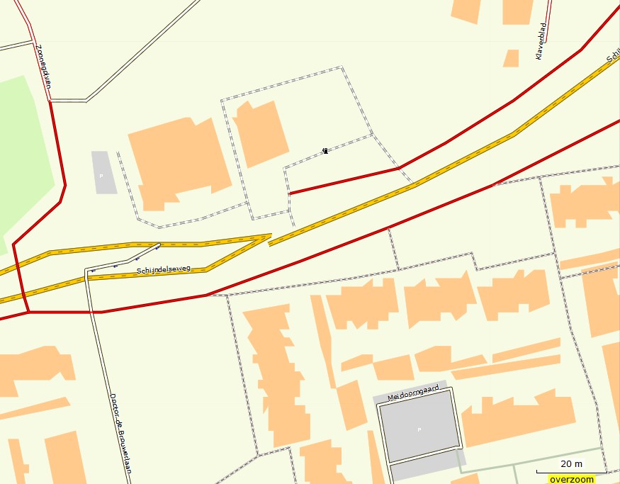
Next issue is the gap. The gap is only visisble with my OFM styles. Other map styles are ok. It appears with r3875 and later. Does not appear with r3847. The hole is exactly at the junction from the Schijndelseweg where two lanes merge, I think mkgmap throws away a connection node? Nothing severe for routing because I dont use those roads for routing (non routable lines). Test file is here: https://drive.google.com/open?id=0B2FG7SFUssGqQVFJUEV4a3NsZ1k <https://drive.google.com/open?id=0B2FG7SFUssGqQVFJUEV4a3NsZ1k> ________________________________ Van: mkgmap-dev <mkgmap-dev-bounces@lists.mkgmap.org.uk> namens lig fietser <ligfietser@hotmail.com> Verzonden: zondag 9 april 2017 02:08:30 Aan: Development list for mkgmap Onderwerp: Re: [mkgmap-dev] gaps in road and other issues with r3875 Hi Gerd, First a minor problem, license2.txt crashes with 3880 but not with mkgmap-r3660, (3847 crashes too) Error reading license file licentie2.txt java.nio.charset.MalformedInputException: Input length = 1 In my args file I have license-file: licentie2.txt It has nothing to do with the gaps. ________________________________ Van: mkgmap-dev <mkgmap-dev-bounces@lists.mkgmap.org.uk> namens Gerd Petermann <GPetermann_muenchen@hotmail.com> Verzonden: zondag 9 april 2017 01:36:55 Aan: Development list for mkgmap Onderwerp: Re: [mkgmap-dev] gaps in road and other issues with r3875 Hi Minko, most changes since r3487 were for the index, 3877 fixed a routing problem. No change regarding RGN or handling of license file, esp. no change that would explain the gap. Don't know how to reproduce that problem. Is it related to OSM data or only to options / contents of other input files ? Please provide a link to a small set of input files + script and let me know what you expect and what you get. Gerd ________________________________________ Von: mkgmap-dev <mkgmap-dev-bounces@lists.mkgmap.org.uk> im Auftrag von lig fietser <ligfietser@hotmail.com> Gesendet: Sonntag, 9. April 2017 10:07:49 An: mkgmap-dev Betreff: [mkgmap-dev] gaps in road and other issues with r3875 Hi, Users of my OFM map have reported gaps in the roads (mainly non routable lines used for highways that are forbidden for cyclists). I've found out this is worse in the latest mkgmap releases 3875, 3880. See the screenshot, the location is https://www.openstreetmap.org/?mlat=51.59253&mlon=5.33765#map=19/51.59253/5.... I have also compiled it with r3847, no gaps. There are other issues. With the default style I cannot even get a working map from the osm file. Something with the overview map is blocking it all? Really strange, if I open the img with gpsmapedit I can see it contains all the data, so something must be wrong with the index or overview files too. I have found out it makes sense if I leave the %typfile% option out or not (see java command below). With no typefile specified, mkgmap r3875 does not show a map. With some typfile behind %argsfile%, everything works as expected (default style does not show a gap). I also noticed this mkgmap version crashed on the license file, something has changed there too? It contained a ©mark. Only after replacing it with (c) mkgmap could finish the job. java -Xmx4000m -jar %MKGMAP% --product-version=%version% --output-dir=%date% --family-id=%FID% --overview-mapname=OFM_%mapname% --series-name="OFM (%mapname%v%date%)" --family-name="OFM (%mapname%)" --area-name="OFM_%mapname%(%date%)" -c %argsfile% %typfile% _______________________________________________ mkgmap-dev mailing list mkgmap-dev@lists.mkgmap.org.uk http://www.mkgmap.org.uk/mailman/listinfo/mkgmap-dev
participants (3)
-
 Gerd Petermann
 -
 lig fietser
 -
 Thomas Morgenstern