Commit: r1497: Merge the mp branch to trunk.

Version 1497 was commited by steve on 2010-01-18 22:36:58 +0000 (Mon, 18 Jan 2010) Merge the mp branch to trunk. Patches were written by WanMil. See ^/branches/mp@1496

Hi I have a map of the UK with sea (using --generate-sea=extend-sea-sectors) This is much better than the last time I tried as it was faster and there is no flooded land. I do get a lot of horizontal and vertical artefacts when zoomed out that go away when I zoom in. I assumed that Mark's patch would be the cure for that, but it doesn't appear to make any difference. Is that right or am I missing something? ..Steve

Hi Steve,
Hi
I have a map of the UK with sea (using --generate-sea=extend-sea-sectors)
This is much better than the last time I tried as it was faster and there is no flooded land.
I do get a lot of horizontal and vertical artefacts when zoomed out that go away when I zoom in.
I assumed that Mark's patch would be the cure for that, but it doesn't appear to make any difference.
Is that right or am I missing something?
..Steve
My patch doesn't fix the H & V artifacts - I believe those are caused by mapsource (they also appear in maps made with cgpsmapper). Sometimes they go away just by panning (without zooming). What my patch does do is remove the "slim triangles" that occur at the junction of polygons. Using the new mp code, I have just made the Baltic map both with and without my patch and I can assure you it is effective in reducing the number of artifacts. It's a shame that the artifacts are so visible in the sea. Although I think the new mp code is a great step forward, I shall keep using generate-sea=polygons simply because the H & V artifacts are less visible (as they are now on the land and not the sea and with a light background colour, they are not so noticeable). Also, when using polygons, the lines at the tile boundaries are covered up. Mark
Also, if you compare our sea with, say, the NZ open GPS map (built using cgpsmapper), there's a lot more artifacts in the NZ map than there is now in our maps (either using polygons or multipolygon). And in response to what Felix has just posted, the NZ maps support routing across multiple tiles in mapsource. I was intrigued to know if our packaging (overview map, tdb, etc.) was causing our maps to fail to route across multiple tiles so I built a map using mkgmap that used the tiles from the NZ map. And guess what, mapsource could route just dandy. So it's not our overview map or tdb that's stopping the multi-tile routing in mapsource, it's something in the tiles (.img) files that's wrong. Mark

On 19.01.2010 00:50, Mark Burton wrote:
Also, if you compare our sea with, say, the NZ open GPS map (built using cgpsmapper), there's a lot more artifacts in the NZ map than there is now in our maps (either using polygons or multipolygon).
And in response to what Felix has just posted, the NZ maps support routing across multiple tiles in mapsource. I was intrigued to know if our packaging (overview map, tdb, etc.) was causing our maps to fail to route across multiple tiles so I built a map using mkgmap that used the tiles from the NZ map. And guess what, mapsource could route just dandy. So it's not our overview map or tdb that's stopping the multi-tile routing in mapsource, it's something in the tiles (.img) files that's wrong.
Sorry for not being very clear. I think the routable overview map would only be used for very long distance routing. So route from tile onto overview map (motorways/trunk_roads/primaries/ferries only) to destination, continue on normal map. I think the overview map is only used if Mapsource cannot route using the normal tiles (e.g. setting avoid highways with City Navigator maps and trying to route from Poland to Portugual ). The main reason for overview map with roads would be to have faster map panning when zoomed out in Mapsource. I hope that once we have no more overlap, map redraw speed also increases (and less flashing up in Mapsource when zoomed out far - if you know what I mean). Well I'm open for testing if new patches come....
Mark _______________________________________________ mkgmap-dev mailing list mkgmap-dev@lists.mkgmap.org.uk http://www.mkgmap.org.uk/mailman/listinfo/mkgmap-dev
Hi Mark
My patch doesn't fix the H& V artifacts - I believe those are caused by mapsource (they also appear in maps made with cgpsmapper).
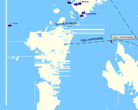
Oh OK, I've attached a picture of the worst bit - that is expected then? I took another look at the NZ maps on your suggestion and there are indeed a few artefacts there which look similar. Interesting. If there is no obvious reason, then reducing the number of sea polygons would be a good idea I suppose. ..Steve
I have never seen it so bad. The lines should ONLY appear on tile boundaries. Now please don't tell me those are all tile boundaries ??? I'll send a screenshot of how the whole Oceania extract looks on my PC in around 15-20 minutes (just kicked in the compiler, last compile was still without sea). On 19.01.2010 00:59, Steve Ratcliffe wrote:
Hi Mark
My patch doesn't fix the H& V artifacts - I believe those are caused by mapsource (they also appear in maps made with cgpsmapper).
Oh OK, I've attached a picture of the worst bit - that is expected then?
I took another look at the NZ maps on your suggestion and there are indeed a few artefacts there which look similar. Interesting. If there is no obvious reason, then reducing the number of sea polygons would be a good idea I suppose.
..Steve
_______________________________________________ mkgmap-dev mailing list mkgmap-dev@lists.mkgmap.org.uk http://www.mkgmap.org.uk/mailman/listinfo/mkgmap-dev
Hi Felix
I have never seen it so bad. The lines should ONLY appear on tile boundaries. Now please don't tell me those are all tile boundaries ???
No they are not tile boundaries, they are boundaries between sea polygons. It is the worst area, most of the map is much better than that. ..Steve
On 19.01.2010 01:05, Steve Ratcliffe wrote:
Hi Felix
I have never seen it so bad. The lines should ONLY appear on tile boundaries. Now please don't tell me those are all tile boundaries ???
No they are not tile boundaries, they are boundaries between sea polygons.
It is the worst area, most of the map is much better than that.
..Steve
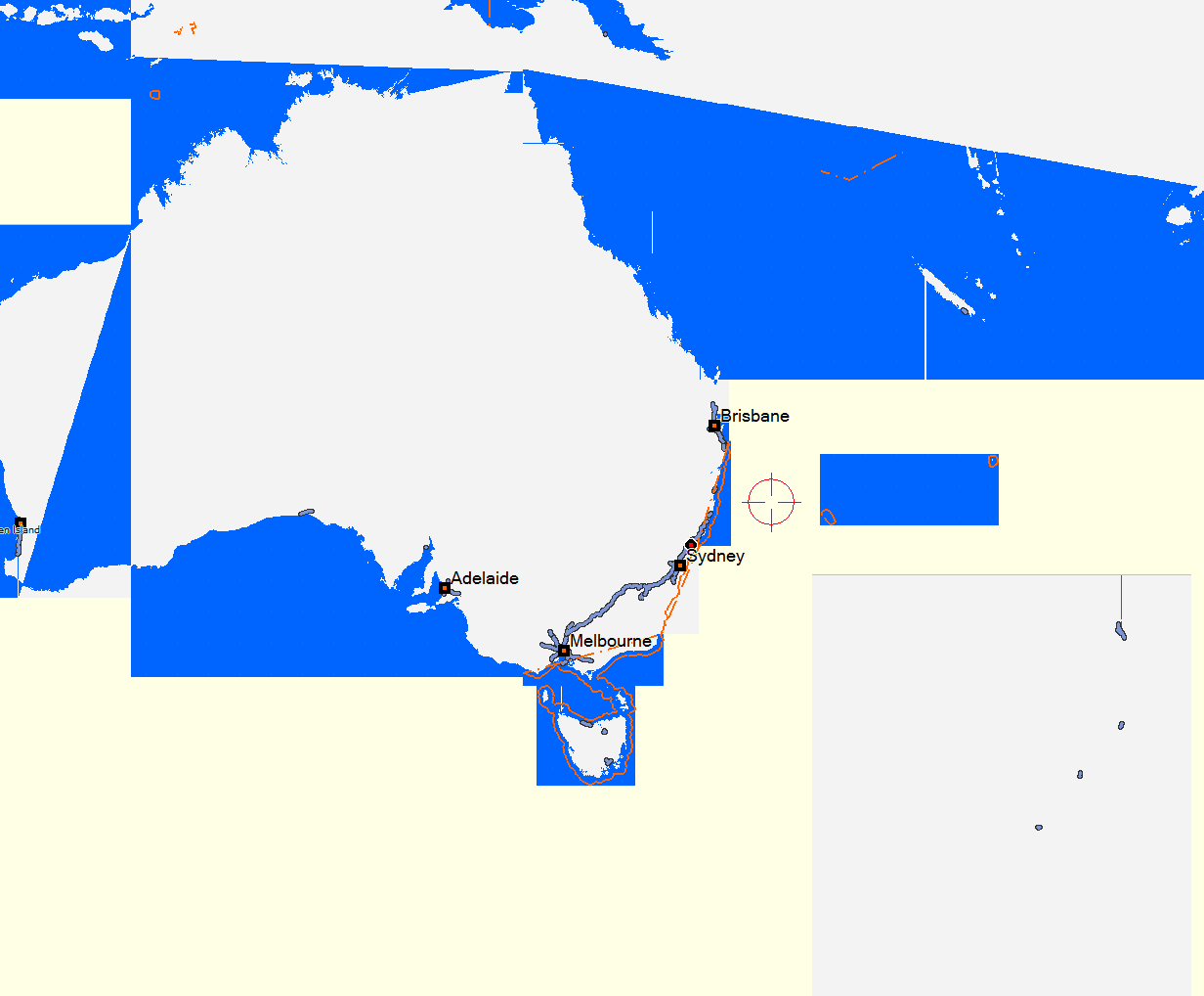
Never seen such errors, on the other hand I just tried --generate-sea,polygons,extend-sea on australia-oceania and the result is more or less no sea at all. I believe the problem here is however, that NZ is too far away from Ozi. Therefore the map gets splitted badly. I have attached a pic (sorry that it is so big but this is already using "highes" detail in Mapsource, still only 21 KB)
On 19.01.2010 00:59, Steve Ratcliffe wrote:
Hi Mark
My patch doesn't fix the H& V artifacts - I believe those are caused by mapsource (they also appear in maps made with cgpsmapper).
Oh OK, I've attached a picture of the worst bit - that is expected then?
I took another look at the NZ maps on your suggestion and there are indeed a few artefacts there which look similar. Interesting. If there is no obvious reason, then reducing the number of sea polygons would be a good idea I suppose.
..Steve
Well first without sea (1500km scale) - these are the only lines that are noticeable on my map compile (no matter how close I zoom in, they won't multiply), you seem to have a completely different problem.
Steve,
Oh OK, I've attached a picture of the worst bit - that is expected then?
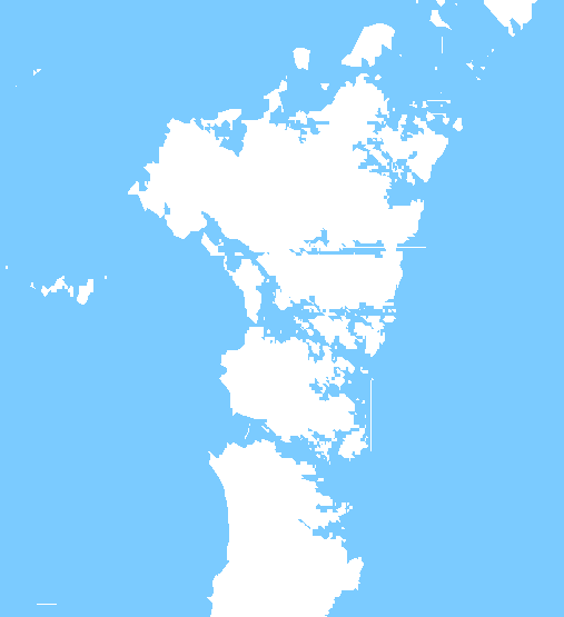
Hmm, that's particularly bad, attached is what I get when using multipolygon (and my h v patch). As you can see, not bad at all. Zooming in and out doesn't make it change very much.
I took another look at the NZ maps on your suggestion and there are indeed a few artefacts there which look similar. Interesting. If there is no obvious reason, then reducing the number of sea polygons would be a good idea I suppose.
Perhaps, but when there is a lot of islands, you are always going to get a lot of sea polygons. That is one definite advantage of using generate-sea=polygons because then you only get one polygon per island and one sea polygon per-tile (obviously, these may be split if they are large). Mark
Actually, I'm really impressed that the mp code can handle that tile at all in a reasonable time. It's interesting to look at it in mapedit. You can see exactly how the sea has been split to fit around the islands. FYI mapedit reports over 16000 sea polys for that tile. By comparison, if I use generate-sea=polygons, it reports around 9000 land polygons. Mark
Hi Mark
Hmm, that's particularly bad, attached is what I get when using multipolygon (and my h v patch). As you can see, not bad at all. Zooming in and out doesn't make it change very much.
All (or almost all at least) of the lines I see go away when I zoom in. In gpsmapedit, I don't notice any gaps between the polygons at any level. I'll take a closer look tomorrow.
Perhaps, but when there is a lot of islands, you are always going to get a lot of sea polygons. That is one definite advantage of using
On Garmin maps there are not that many polygons as they surround the islands. ..Steve
All (or almost all at least) of the lines I see go away when I zoom in. In gpsmapedit, I don't notice any gaps between the polygons at any level. I'll take a closer look tomorrow.
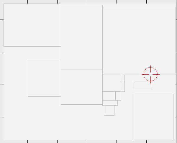
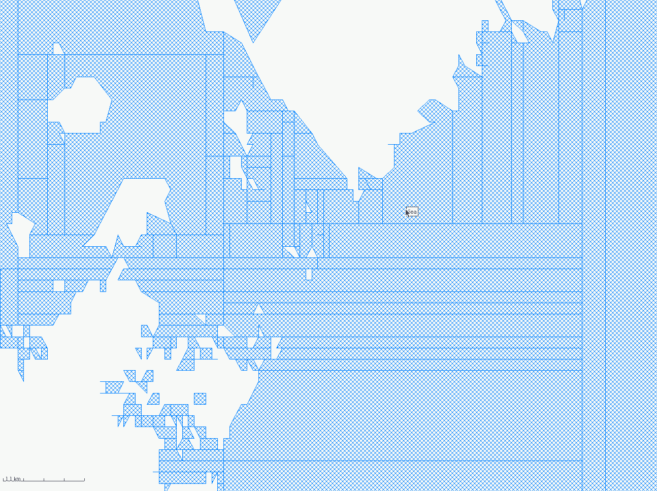
OK here is an image of the sea polygons as seen in mapedit. This is at level 4 (most zoomed out). Does this splitting happen at the generate sea stage or is it being mangled later on? ..Steve

All (or almost all at least) of the lines I see go away when I zoom in. In gpsmapedit, I don't notice any gaps between the polygons at any level. I'll take a closer look tomorrow.
OK here is an image of the sea polygons as seen in mapedit. This is at level 4 (most zoomed out).
Does this splitting happen at the generate sea stage or is it being mangled later on?
..Steve
I don't think that the artefacts are from the new mp code. Why? mp takes the outer polygon po and the for each inner polygon pi it creates the subtraction po-pi and divides po' at half of the largest edge of pi. This creates 2 or more singular polygons from which the rest of the inner polygons are subtracted using the same algorithm. In the end an artefact created by the mp code should always divide an inner polygon at its half. For some islands this is true but there are several islands and lines for which this rule does not match. WanMil
On 19.01.2010 00:26, Steve Ratcliffe wrote:
Hi
I have a map of the UK with sea (using --generate-sea=extend-sea-sectors)
This is much better than the last time I tried as it was faster and there is no flooded land.
I do get a lot of horizontal and vertical artefacts when zoomed out that go away when I zoom in.
I assumed that Mark's patch would be the cure for that, but it doesn't appear to make any difference.
Is that right or am I missing something?
No, I think there is simply still some work missing. I would use --generate-sea=polygons,extend-sea-sectors, I think it gives better performance in Mapsource or GPS (please speak up stranger if you had time to really compare and tell if it is advisable to use or not). IMHO the main problem is here that mkgmap still has no decent overview map (ideally we would have a non empty overview map). My top3 of what mkgmap still is missing or doing wrong: 1. Address Search only working in Mapsource (or inside active tile on "old generation" GPS) 2. Overview map empty and a bit incorrect 3. Routing over tile boundaries in Mapsource -if solved the overlap should not be needed (size decrease). Once 1-3 are implemented, mkgmap has no more disadvantages at all compared to cgpsmapper pro (costing big $$$$), and many many advantages. It really shows how successful open source is. BTW - I would have guessed that sea polygons will still take ages until correctly implemented (on the other hand I thought 2-3 month ago it will only be a matter of days until address search works not only in Mapsource but also on GPS correctly). In my opinion less important/major things to get right: # transliterations (there seems to be some good work according to the osm forum mkgmap section) # coping better with contourline maps (e.g. some possibility to get rid of those long straight lines that happen on data holes) # using units. most importantly make it possible to calculate from miles to kilometers, from feet to meters... (would be enough if one could have multiplication with factors in style-file). # I'll certainly have more ideas/wishes once the above is implemented.
Hi Felix Some comments on the items in your list that I am planning to look at or have comments on:
1. Address Search only working in Mapsource (or inside active tile on "old generation" GPS)
Is a Legend Cx old generation? On mine I can find addresses in different tiles, but not always, some addresses work and some don't. Unfortunately this is blocked as I have no idea what the problem is.
2. Overview map empty and a bit incorrect
I will probably start working on that soon.
In my opinion less important/major things to get right: # transliterations (there seems to be some good work according to the osm forum mkgmap section)
I will send a message tommorow about the translit branch. It will not be as good as the work on the forum, but probably better than question marks, at least in some countries. I'd like to integrate the work by the forum's greencaps if that is possible, but no code is available yet and I therefore have no idea what is involved. ..Steve
participants (5)
-
 Felix Hartmann
 -
 Mark Burton
 -
 Steve Ratcliffe
 -
 svn commit
 -
 WanMil