link-pois-to-ways tags

Hi all, a few weeks ago we discussed the tags which should trigger the link-pois-to-ways option. The current implementation works like this: Each node with a tag access=*, barrier=*, or highway=* is handled as a POI (before style processing). Ways with such a node are tagged with mkgmap:way-has-pois=true. If the style assigns mkgmap:road-class=* or mkgmap:road-speed=* or one of the access tags (mkgmap:bicycle,mkgmap:foot,...,mkgmap:delivery) the node may change routing. WanMil suggested to remove access=* from the list of triggers, as it is too likely to be something like amenity=parking, access=private . This was forgotten during the merge of the mergeroads branch, so I've done it now with r3115. Gerd

Question about those access tags. Is there an easy way to display on the map all tags that a node has, for instance if you point with your mouse on a bollard it would list: barrier=bollard access=designated bicycle=yes foot=yes motorcar=no etc?
Hi Minko, I am not sure about the limits in the Garmin format, but it should be easy to write a method like echotags that returns the string instead of writing it to stderr. Gerd
Date: Tue, 18 Mar 2014 09:57:43 +0100 From: ligfietser@online.nl To: mkgmap-dev@lists.mkgmap.org.uk Subject: Re: [mkgmap-dev] link-pois-to-ways tags
Question about those access tags. Is there an easy way to display on the map all tags that a node has, for instance if you point with your mouse on a bollard it would list:
barrier=bollard access=designated bicycle=yes foot=yes motorcar=no etc? _______________________________________________ mkgmap-dev mailing list mkgmap-dev@lists.mkgmap.org.uk http://www.mkgmap.org.uk/mailman/listinfo/mkgmap-dev
Great, looking forward for this. Don't know if GPS or Mapsource/Basecamp will show everything but we'll see. At the moment I misuse addr:street tags etc to show some information of barriers but this is a bad workaround.
I am not sure about the limits in the Garmin format, but it should be easy to write a method like echotags that returns the string instead of writing it to stderr.
Gerd
Hi Minko, well, I don't know where to put the string, I just say that it is easy to calculate it ;-) Gerd
Date: Tue, 18 Mar 2014 10:58:17 +0100 From: ligfietser@online.nl To: mkgmap-dev@lists.mkgmap.org.uk Subject: Re: [mkgmap-dev] link-pois-to-ways tags
Great, looking forward for this. Don't know if GPS or Mapsource/Basecamp will show everything but we'll see. At the moment I misuse addr:street tags etc to show some information of barriers but this is a bad workaround.
I am not sure about the limits in the Garmin format, but it should be easy to write a method like echotags that returns the string instead of writing it to stderr.
Gerd
mkgmap-dev mailing list mkgmap-dev@lists.mkgmap.org.uk http://www.mkgmap.org.uk/mailman/listinfo/mkgmap-dev
I understand I'll still have to use some hacks like { add mkgmap:housenumber='(${barrier})' ; add mkgmap:street='bicycle:${bicycle}' ; add mkgmap:postal_code='open: ${opening_hours}' ; } But anyway, it will be made more easier to retrieve all tags instead of guessing which tag to print, like 'bicycle:${bicycle}' or 'motorcar:${motorcar}' etc
well, I don't know where to put the string, I just say that it is easy to calculate it ;-)
Gerd
Hi Minko, attached is a patch that provides the all_tags() function which returns all tags of an element (in no particular order). Complied binary based on r3116 is here: http://files.mkgmap.org.uk/download/184/mkgmap.jar I did not test it, but I hope that's what you need. Gerd
Date: Tue, 18 Mar 2014 11:23:37 +0100 From: ligfietser@online.nl To: mkgmap-dev@lists.mkgmap.org.uk Subject: Re: [mkgmap-dev] link-pois-to-ways tags
I understand I'll still have to use some hacks like { add mkgmap:housenumber='(${barrier})' ; add mkgmap:street='bicycle:${bicycle}' ; add mkgmap:postal_code='open: ${opening_hours}' ; }
But anyway, it will be made more easier to retrieve all tags instead of guessing which tag to print, like 'bicycle:${bicycle}' or 'motorcar:${motorcar}' etc
well, I don't know where to put the string, I just say that it is easy to calculate it ;-)
Gerd
mkgmap-dev mailing list mkgmap-dev@lists.mkgmap.org.uk http://www.mkgmap.org.uk/mailman/listinfo/mkgmap-dev
Thanks Gerd, But how do I get all_tags() in for instance the name field?
attached is a patch that provides the all_tags() function which returns all tags of an element (in no particular order).
Complied binary based on r3116 is here: http://files.mkgmap.org.uk/download/184/mkgmap.jar
I did not test it, but I hope that's what you need.
Gerd
Hi Minko, I really don't know. Can't you use the set command? Gerd
Date: Wed, 19 Mar 2014 17:29:50 +0100 From: ligfietser@online.nl To: mkgmap-dev@lists.mkgmap.org.uk Subject: Re: [mkgmap-dev] link-pois-to-ways tags
Thanks Gerd, But how do I get all_tags() in for instance the name field?
attached is a patch that provides the all_tags() function which returns all tags of an element (in no particular order).
Complied binary based on r3116 is here: http://files.mkgmap.org.uk/download/184/mkgmap.jar
I did not test it, but I hope that's what you need.
Gerd
mkgmap-dev mailing list mkgmap-dev@lists.mkgmap.org.uk http://www.mkgmap.org.uk/mailman/listinfo/mkgmap-dev
Hi Minko, can't try it now, but I'd say it should be barrier=* {set name = all_tags()} [0x1108 resolution 23] I don't see any example where the return value of a function is used to set a variable, so maybe this doesn't work at all? Gerd ligfietser wrote
Hi Gerd, I tried barrier=* {set name='${all_tags}'} [0x1108 resolution 23] or { name '${all_tags()}'} but this doesnt show anything
I really don't know. Can't you use the set command?
Gerd
Thanks Gerd, But how do I get all_tags() in for instance the name field?
mkgmap-dev mailing list
mkgmap-dev@.org
-- View this message in context: http://gis.19327.n5.nabble.com/link-pois-to-ways-tags-tp5800124p5800338.html Sent from the Mkgmap Development mailing list archive at Nabble.com.
Gerd wrote:
can't try it now, but I'd say it should be barrier=* {set name = all_tags()} [0x1108 resolution 23]
This sets the name to "all_tags" ;-)
I don't see any example where the return value of a function is used to set a variable, so maybe this doesn't work at all?
I guess so. Nevermind, it's not so important so don't spend too much time on this.

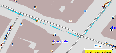
Hi Gerd, is there any hard-coded processing of points "highway=crossing"? I can get ride of deformation of roads at these points. I have tried: highway=crossing {delete highway} and compilation without link-pois-to-ways option. I use mkgmap r3116, I always get roads like on attached picture. -- Best regards, Andrzej
Hi Andrzej, I see no hardcoded handling of highway=crossing. Do you see this problem also with the default style? If yes, please post the id of the node. Gerd popej wrote
Hi Gerd,
is there any hard-coded processing of points "highway=crossing"? I can get ride of deformation of roads at these points. I have tried:
highway=crossing {delete highway}
and compilation without link-pois-to-ways option. I use mkgmap r3116, I always get roads like on attached picture.
-- Best regards, Andrzej
_______________________________________________ mkgmap-dev mailing list
mkgmap-dev@.org
http://www.mkgmap.org.uk/mailman/listinfo/mkgmap-dev
crossing.png (14K) <http://gis.19327.n5.nabble.com/attachment/5800562/0/crossing.png>;
-- View this message in context: http://gis.19327.n5.nabble.com/link-pois-to-ways-tags-tp5800124p5800564.html Sent from the Mkgmap Development mailing list archive at Nabble.com.
Hi Gerd,
I see no hardcoded handling of highway=crossing.
My bad, wrong guess and wrong thread. Problem is due to option make-opposite-cycleway. When used, way gets additional nodes, which accidentally happen to be crossing. Without crossing tag, mkgmap behave the same. See attached sample and node: http://www.openstreetmap.org/node/2650495576 Compilation with simple command: mkgmap --route --make-opposite-cycleways crossing.osm -- Best regards, Andrzej
Hi Andrzej, ah, yes, that one shows the problem. The additional cycle way is added with a different (OSM) id (osm id incremented by CYCLEWAY_ID_OFFSET (0x10000000)). Therefore all points of the original way appear on two different roads, all highway counts are incremented and thus the obsolete point is no longer considered obsolete. I see two simple fixes: 1) don't increment the id 2) consider two way ids as identical when they differ by CYCLEWAY_ID_OFFSET and follow each other. I don't know why the offset was added, so I don't dare to remove it. Attached is a patch for the 2nd approach. @Steve: svn blame says the code with the CYCLEWAY_ID_OFFSET was added by you. Please check if that is (still) needed, I think it was just added to be able to identify these special ways when debugging? Gerd Date: Fri, 21 Mar 2014 20:23:48 +0100 From: popej@poczta.onet.pl To: mkgmap-dev@lists.mkgmap.org.uk Subject: Re: [mkgmap-dev] link-pois-to-ways tags Hi Gerd,
I see no hardcoded handling of highway=crossing.
My bad, wrong guess and wrong thread. Problem is due to option make-opposite-cycleway. When used, way gets additional nodes, which accidentally happen to be crossing. Without crossing tag, mkgmap behave the same. See attached sample and node: http://www.openstreetmap.org/node/2650495576 Compilation with simple command: mkgmap --route --make-opposite-cycleways crossing.osm -- Best regards, Andrzej _______________________________________________ mkgmap-dev mailing list mkgmap-dev@lists.mkgmap.org.uk http://www.mkgmap.org.uk/mailman/listinfo/mkgmap-dev

On 21/03/14 20:10, Gerd Petermann wrote:
@Steve: svn blame says the code with the CYCLEWAY_ID_OFFSET was added by you. Please check if that is (still) needed, I think it was just added to be able to identify these special ways when debugging?
It was really added to Osm5XmlHandler in r1044. So I've no opinion on what it is for. Probably just to help debugging as you say. Change it as you see fit. ..Steve
Hi Gerd,
Attached is a patch for the 2nd approach.
Unfortunately it doesn't solve the problem. See for example this node in previously provided sample: http://www.openstreetmap.org/node/2650495573 If I use whole tile from my map, then even the node, which is removed in sample, still remains. -- Best regards, Andrzej
Hi Andrzej, fine :-) The previous patch worked for me as well, but r3117 is the cleaner solution, as it is closer to the alternative that uses continue in the style to create additional ways. Gerd
Date: Fri, 21 Mar 2014 23:33:47 +0100 From: popej@poczta.onet.pl To: mkgmap-dev@lists.mkgmap.org.uk Subject: Re: [mkgmap-dev] link-pois-to-ways tags
Hi Gerd,
release r3117 seems to be correct, thanks!
-- Best regards, Andrzej _______________________________________________ mkgmap-dev mailing list mkgmap-dev@lists.mkgmap.org.uk http://www.mkgmap.org.uk/mailman/listinfo/mkgmap-dev
participants (5)
-
 Andrzej Popowski
 -
 Gerd Petermann
 -
GerdP
-
 Minko
Minko -
 Steve Ratcliffe