
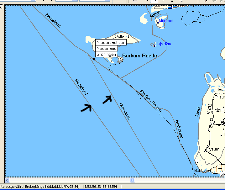
Hi, I see in Mapsource many boundary lines which are not existing in the OSM data. See attached screen shot. Are these lines coming from the multipolygon processing? Data is from the geofabrik germany extract. Chris

Chris-Hein Lunkhusen schrieb am 27.03.2010 20:44:
I see in Mapsource many boundary lines which are not existing in the OSM data. See attached screen shot.
Are these lines coming from the multipolygon processing?
Probably yes. On 17.02. WanMil provided a patch, that allowed the distinction between the original (source) ways of a multipolygon and the artifical (generated) ways from the mkgmap multipolygon processing. But to make use of this patch you must adapt your style file, so it was never commited to the trunk. Gruss Torstebn
Torsten Leistikow schrieb:
I see in Mapsource many boundary lines which are not existing in the OSM data. See attached screen shot.
Are these lines coming from the multipolygon processing?
Probably yes.
On 17.02. WanMil provided a patch, that allowed the distinction between the original (source) ways of a multipolygon and the artifical (generated) ways from the mkgmap multipolygon processing. But to make use of this patch you must adapt your style file, so it was never commited to the trunk.
I don't know how the MP code works, but it should not copy tags like boundary=* to the multipolygon cutting lines. Chris
Chris-Hein Lunkhusen schrieb am 28.03.2010 14:22:
I don't know how the MP code works, but it should not copy tags like boundary=* to the multipolygon cutting lines.
They should stop putting the boundaries into multipolygons. The problem is, that the boundaries are tagged as areas (thats the meaning of using multipolygons), but they are drawn on the maps as lines around the border of the area. The boundary multipolygons are handled the same way as all multipolygons. If a multipolygon is cut into smaller pieces, all pieces are tagged in the same way as the original multipolygon. Gruss Torsten

On Sun, Mar 28, 2010 at 03:34:58PM +0200, Torsten Leistikow wrote:
Chris-Hein Lunkhusen schrieb am 28.03.2010 14:22:
I don't know how the MP code works, but it should not copy tags like boundary=* to the multipolygon cutting lines.
They should stop putting the boundaries into multipolygons.
Would it be possible to control the MultiPolygon handler from the relations style file, something like this: type=multipolygon & boundary!=* { set mkgmap:multipolygon=1 } Something like this would allow one to create multipolygons for administrative areas that are not tagged as type=multipolygon. Examples: highlighting Russia+Kaliningrad, or highlighting the province around a city differently from the city.
The problem is, that the boundaries are tagged as areas (thats the meaning of using multipolygons), but they are drawn on the maps as lines around the border of the area.
Another problem is (as far as I understand) that it is not possible to distinguish multipolygon cutting lines from original multipolygon role=* lines. The output of the MultiPolygon handler is really areas, not lines. Marko
participants (3)
-
 Chris-Hein Lunkhusen
 -
 Marko Mäkelä
 -
 Torsten Leistikow