
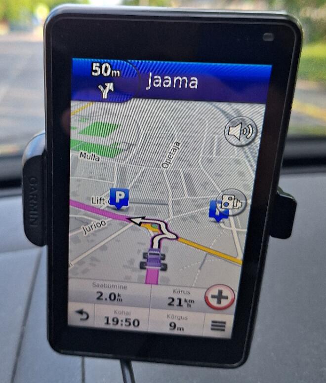
Hello, I compiled my first gmapsupp.img and on test drive garmin offered an obviously wrong route on a roundabout (garmin.jpg). On OpenStreetMap i get the same wrong route with algorithm Car (Valhalla), but Bicycle (Valhalla) and other routing algorithms will give the correct route. https://www.openstreetmap.org/directions?engine=fossgis_valhalla_car&route=5... I followed the instructions from https://wiki.openstreetmap.org/wiki/Mkgmap/help/How_to_create_a_map mkgmap \ --route \ --add-pois-to-areas \ --bounds=bounds \ --index \ --gmapsupp \ 6324*.osm.pbf Have I missed an important option? Is it possible to fix the problem in compilation phase or is it something confusing for Garmin algorithm in OpenStreetMap data? If it helps, then I have uploaded the gmapsupp.img for possible inspection to the address https://0x0.st/XNpC.img/gmapsupp.img Any helpful insights are welcome. Oskar Ohakas

Hi, when i look at the routing and the map that you provided via the link, it looks like the road section leading into the roundabout is wrongly connected, hence the routing goes wrong. I dont know the location as i am not from there, but checking satellite and google street view made me update the map and the entrances to the roundabout. I think it may still need some update, but hope fully it should work better now. Try online first, data to download may be updated only daily. Car grashopper and OSRM works. Regards Karl On torsdag 30 maj 2024 06:52:10 CEST Oskar Ohakas wrote:
Hello,
I compiled my first gmapsupp.img and on test drive garmin offered an obviously wrong route on a roundabout (garmin.jpg). On OpenStreetMap i get the same wrong route with algorithm Car (Valhalla), but Bicycle (Valhalla) and other routing algorithms will give the correct route. https://www.openstreetmap.org/directions?engine=fossgis_valhalla_car&route= 58.93979%2C23.53421%3B58.93934%2C23.53611#map=19/58.93949/23.53509
I followed the instructions from https://wiki.openstreetmap.org/wiki/Mkgmap/help/How_to_create_a_map
mkgmap \ --route \ --add-pois-to-areas \ --bounds=bounds \ --index \ --gmapsupp \ 6324*.osm.pbf
Have I missed an important option? Is it possible to fix the problem in compilation phase or is it something confusing for Garmin algorithm in OpenStreetMap data? If it helps, then I have uploaded the gmapsupp.img for possible inspection to the address https://0x0.st/XNpC.img/gmapsupp.img
Any helpful insights are welcome.
Oskar Ohakas

Hi Oskar, I think the mapping of the roundabout is part of the problem. It's diameter is a bit too small and therefore the connection of the way https://www.openstreetmap.org/way/78515591 is not on the roundabout but on https://www.openstreetmap.org/way/78515465 I think the roundabout should be enlarged and way 78515591 should be connected to it. I also wonder why this short part of the road doesn't have the name=Kalda tag. The router Valhalla is rather new, maybe you should report the issue to its developers. Anyhow, I don't see the wrong results with a small Garmin map compiled for that area (tested with MapSource and Basecamp), also not with your map loaded into Basecamp. I get the expected route similar to that from Graphhopper. You may want to add --link-pois-to-ways to your options, but that is not important here. Maybe you have a special configuration on your device? ciao, Gerd P.S. Karl modifed the OSM data while I was writing my reply, so some comments may no longer make sense, but I hope you get the idea. ________________________________________ Von: mkgmap-dev <mkgmap-dev-bounces@lists.mkgmap.org.uk> im Auftrag von Oskar Ohakas <oskar.ohakas@proton.me> Gesendet: Donnerstag, 30. Mai 2024 06:52 An: mkgmap-dev@lists.mkgmap.org.uk Betreff: [mkgmap-dev] Wrong route on roundabout Hello, I compiled my first gmapsupp.img and on test drive garmin offered an obviously wrong route on a roundabout (garmin.jpg). On OpenStreetMap i get the same wrong route with algorithm Car (Valhalla), but Bicycle (Valhalla) and other routing algorithms will give the correct route. https://www.openstreetmap.org/directions?engine=fossgis_valhalla_car&route=5... I followed the instructions from https://wiki.openstreetmap.org/wiki/Mkgmap/help/How_to_create_a_map mkgmap \ --route \ --add-pois-to-areas \ --bounds=bounds \ --index \ --gmapsupp \ 6324*.osm.pbf Have I missed an important option? Is it possible to fix the problem in compilation phase or is it something confusing for Garmin algorithm in OpenStreetMap data? If it helps, then I have uploaded the gmapsupp.img for possible inspection to the address https://0x0.st/XNpC.img/gmapsupp.img Any helpful insights are welcome. Oskar Ohakas
participants (3)
-
 7770
7770 -
 Gerd Petermann
 -
 Oskar Ohakas