Limit the number of highway shields in basecamp and gps

Hello Is there a way to limit the number (or extend the distance) of highway shields in basecamp? On some zoomlevels the usage of ${ref | highway-symbol:hbox}' generates so many boxes, making the map difficult to read. Thx Joris

Hi Joris, the ony switch that I know is the "map detail (level)" (ranges from lowest to highest). No idea if that helps. If not, please provide the location of such an area. Gerd ________________________________________ Von: mkgmap-dev <mkgmap-dev-bounces@lists.mkgmap.org.uk> im Auftrag von Joris Bo <jorisbo@hotmail.com> Gesendet: Montag, 12. März 2018 09:17:36 An: Development list for mkgmap Betreff: [mkgmap-dev] Limit the number of highway shields in basecamp and gps Hello Is there a way to limit the number (or extend the distance) of highway shields in basecamp? On some zoomlevels the usage of ${ref | highway-symbol:hbox}' generates so many boxes, making the map difficult to read. Thx Joris _______________________________________________ mkgmap-dev mailing list mkgmap-dev@lists.mkgmap.org.uk http://www.mkgmap.org.uk/mailman/listinfo/mkgmap-dev
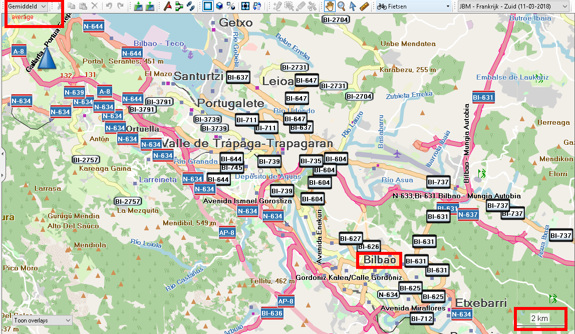
Hallo Gerd Changing the detailed-level in basecamp does help but has also impacts on the rest. It's actually shifting the 'problem' to a different zoomlevel. Basecamp or my Oregon decides where to show such shields but no idea which mechanism is used to calculate such and if its possible to influence that behaviour when building the map.. Example Screenshot shows city of Bilbao (N43° 17.489' W3° 00.430') in northern Spain at basecamp level 'Average' Motorway, Trunks and primary all have different highway shield s For example: Having 2 to 4 shields of N-634 would be enough. highway = motorway {name '${ref | highway-symbol:hbox} ${name}' | '${ref | highway-symbol:hbox}' | '${name}'} highway = motorway {name '${ref | highway-symbol:hbox} ${name}' | '${ref | highway-symbol:hbox}' | '${name}'} highway = trunk {name '${ref|highway-symbol:hbox} ${name}' | '${ref|highway-symbol:hbox}' | '${name}'; addlabel '${name} (${ref})'} highway = trunk {name '${ref|highway-symbol:hbox} ${name}' | '${ref|highway-symbol:hbox}' | '${name}'; addlabel '${name} (${ref})'} highway = primary {name '${ref|highway-symbol:box} ${name}' | '${ref|highway-symbol:box}' | '${name}'; addlabel '${name} (${ref})'} highway = primary {name '${ref|highway-symbol:box} ${name}' | '${ref|highway-symbol:box}' | '${name}'; addlabel '${name} (${ref})'} highway = secondary | highway = tertiary {name '${ref|highway-symbol:oval} ${name}' | '${ref|highway-symbol:oval}' | '${name}'; addlabel '${name} (${ref})'} highway = secondary | highway = tertiary {name '${ref|highway-symbol:oval} ${name}' | '${ref|highway-symbol:oval}' | '${name}'; addlabel '${name} (${ref})'} [cid:image001.png@01D3B9E7.8A3A3210] -----Oorspronkelijk bericht----- Van: mkgmap-dev <mkgmap-dev-bounces@lists.mkgmap.org.uk> Namens Gerd Petermann Verzonden: maandag 12 maart 2018 09:24 Aan: Development list for mkgmap <mkgmap-dev@lists.mkgmap.org.uk> Onderwerp: Re: [mkgmap-dev] Limit the number of highway shields in basecamp and gps Hi Joris, the ony switch that I know is the "map detail (level)" (ranges from lowest to highest). No idea if that helps. If not, please provide the location of such an area. Gerd ________________________________________ Von: mkgmap-dev <mkgmap-dev-bounces@lists.mkgmap.org.uk<mailto:mkgmap-dev-bounces@lists.mkgmap.org.uk>> im Auftrag von Joris Bo <jorisbo@hotmail.com<mailto:jorisbo@hotmail.com>> Gesendet: Montag, 12. März 2018 09:17:36 An: Development list for mkgmap Betreff: [mkgmap-dev] Limit the number of highway shields in basecamp and gps Hello Is there a way to limit the number (or extend the distance) of highway shields in basecamp? On some zoomlevels the usage of ${ref | highway-symbol:hbox}' generates so many boxes, making the map difficult to read. Thx Joris _______________________________________________ mkgmap-dev mailing list mkgmap-dev@lists.mkgmap.org.uk<mailto:mkgmap-dev@lists.mkgmap.org.uk> http://www.mkgmap.org.uk/mailman/listinfo/mkgmap-dev _______________________________________________ mkgmap-dev mailing list mkgmap-dev@lists.mkgmap.org.uk<mailto:mkgmap-dev@lists.mkgmap.org.uk> http://www.mkgmap.org.uk/mailman/listinfo/mkgmap-dev
Hi Joris, sorry, don't understand this. Do you use these rules in your style or do you propose to use them ? They seem to duplicate the highway shields. Please compare with the rules in the default style: # Display highway shield for mayor roads if they have a ref and make them searchable by their name (highway=motorway | highway=trunk) & ref=* { name '${ref|highway-symbol:hbox}'; addlabel '${name}' } highway=primary & ref=* { name '${ref|highway-symbol:box}'; addlabel '${name}' } (highway=secondary | highway=tertiary) & ref=* { name '${ref|highway-symbol:oval}'; addlabel '${name}' } Gerd ________________________________________ Von: mkgmap-dev <mkgmap-dev-bounces@lists.mkgmap.org.uk> im Auftrag von Joris Bo <jorisbo@hotmail.com> Gesendet: Montag, 12. März 2018 09:54:19 An: Development list for mkgmap Betreff: Re: [mkgmap-dev] Limit the number of highway shields in basecamp and gps Hallo Gerd Changing the detailed-level in basecamp does help but has also impacts on the rest. It's actually shifting the ‘problem’ to a different zoomlevel. Basecamp or my Oregon decides where to show such shields but no idea which mechanism is used to calculate such and if its possible to influence that behaviour when building the map.. Example Screenshot shows city of Bilbao (N43° 17.489' W3° 00.430') in northern Spain at basecamp level ‘Average’ Motorway, Trunks and primary all have different highway shield s For example: Having 2 to 4 shields of N-634 would be enough. highway = motorway {name '${ref | highway-symbol:hbox} ${name}' | '${ref | highway-symbol:hbox}' | '${name}'} highway = motorway {name '${ref | highway-symbol:hbox} ${name}' | '${ref | highway-symbol:hbox}' | '${name}'} highway = trunk {name '${ref|highway-symbol:hbox} ${name}' | '${ref|highway-symbol:hbox}' | '${name}'; addlabel '${name} (${ref})'} highway = trunk {name '${ref|highway-symbol:hbox} ${name}' | '${ref|highway-symbol:hbox}' | '${name}'; addlabel '${name} (${ref})'} highway = primary {name '${ref|highway-symbol:box} ${name}' | '${ref|highway-symbol:box}' | '${name}'; addlabel '${name} (${ref})'} highway = primary {name '${ref|highway-symbol:box} ${name}' | '${ref|highway-symbol:box}' | '${name}'; addlabel '${name} (${ref})'} highway = secondary | highway = tertiary {name '${ref|highway-symbol:oval} ${name}' | '${ref|highway-symbol:oval}' | '${name}'; addlabel '${name} (${ref})'} highway = secondary | highway = tertiary {name '${ref|highway-symbol:oval} ${name}' | '${ref|highway-symbol:oval}' | '${name}'; addlabel '${name} (${ref})'} [cid:image001.png@01D3B9E7.8A3A3210] -----Oorspronkelijk bericht----- Van: mkgmap-dev <mkgmap-dev-bounces@lists.mkgmap.org.uk> Namens Gerd Petermann Verzonden: maandag 12 maart 2018 09:24 Aan: Development list for mkgmap <mkgmap-dev@lists.mkgmap.org.uk> Onderwerp: Re: [mkgmap-dev] Limit the number of highway shields in basecamp and gps Hi Joris, the ony switch that I know is the "map detail (level)" (ranges from lowest to highest). No idea if that helps. If not, please provide the location of such an area. Gerd ________________________________________ Von: mkgmap-dev <mkgmap-dev-bounces@lists.mkgmap.org.uk<mailto:mkgmap-dev-bounces@lists.mkgmap.org.uk>> im Auftrag von Joris Bo <jorisbo@hotmail.com<mailto:jorisbo@hotmail.com>> Gesendet: Montag, 12. März 2018 09:17:36 An: Development list for mkgmap Betreff: [mkgmap-dev] Limit the number of highway shields in basecamp and gps Hello Is there a way to limit the number (or extend the distance) of highway shields in basecamp? On some zoomlevels the usage of ${ref | highway-symbol:hbox}' generates so many boxes, making the map difficult to read. Thx Joris _______________________________________________ mkgmap-dev mailing list mkgmap-dev@lists.mkgmap.org.uk<mailto:mkgmap-dev@lists.mkgmap.org.uk> http://www.mkgmap.org.uk/mailman/listinfo/mkgmap-dev _______________________________________________ mkgmap-dev mailing list mkgmap-dev@lists.mkgmap.org.uk<mailto:mkgmap-dev@lists.mkgmap.org.uk> http://www.mkgmap.org.uk/mailman/listinfo/mkgmap-dev
Hello Gerd, Sorry for the confusion I was sloppy pasting the lines form my search window instead of the style file its self That's why there are 4 times 2 of the same lines They also where different from the default, (can't remember me changing it) So first í'll reverse them back to the default and test again also with @Arndt suggestion of the basecamp slider under options. Then see what happens on the Oregon gps Thx again Gr Joris Bovens @Development list for mkgmap -----Oorspronkelijk bericht----- Van: mkgmap-dev <mkgmap-dev-bounces@lists.mkgmap.org.uk> Namens Gerd Petermann Verzonden: maandag 12 maart 2018 11:21 Aan: Development list for mkgmap <mkgmap-dev@lists.mkgmap.org.uk> Onderwerp: Re: [mkgmap-dev] Limit the number of highway shields in basecamp and gps Hi Joris, sorry, don't understand this. Do you use these rules in your style or do you propose to use them ? They seem to duplicate the highway shields. Please compare with the rules in the default style: # Display highway shield for mayor roads if they have a ref and make them searchable by their name (highway=motorway | highway=trunk) & ref=* { name '${ref|highway-symbol:hbox}'; addlabel '${name}' } highway=primary & ref=* { name '${ref|highway-symbol:box}'; addlabel '${name}' } (highway=secondary | highway=tertiary) & ref=* { name '${ref|highway-symbol:oval}'; addlabel '${name}' } Gerd ________________________________________ Von: mkgmap-dev <mkgmap-dev-bounces@lists.mkgmap.org.uk> im Auftrag von Joris Bo <jorisbo@hotmail.com> Gesendet: Montag, 12. März 2018 09:54:19 An: Development list for mkgmap Betreff: Re: [mkgmap-dev] Limit the number of highway shields in basecamp and gps Hallo Gerd Changing the detailed-level in basecamp does help but has also impacts on the rest. It's actually shifting the 'problem' to a different zoomlevel. Basecamp or my Oregon decides where to show such shields but no idea which mechanism is used to calculate such and if its possible to influence that behaviour when building the map.. Example Screenshot shows city of Bilbao (N43° 17.489' W3° 00.430') in northern Spain at basecamp level 'Average' Motorway, Trunks and primary all have different highway shield s For example: Having 2 to 4 shields of N-634 would be enough. highway = motorway {name '${ref | highway-symbol:hbox} ${name}' | '${ref | highway-symbol:hbox}' | '${name}'} highway = motorway {name '${ref | highway-symbol:hbox} ${name}' | '${ref | highway-symbol:hbox}' | '${name}'} highway = trunk {name '${ref|highway-symbol:hbox} ${name}' | '${ref|highway-symbol:hbox}' | '${name}'; addlabel '${name} (${ref})'} highway = trunk {name '${ref|highway-symbol:hbox} ${name}' | '${ref|highway-symbol:hbox}' | '${name}'; addlabel '${name} (${ref})'} highway = primary {name '${ref|highway-symbol:box} ${name}' | '${ref|highway-symbol:box}' | '${name}'; addlabel '${name} (${ref})'} highway = primary {name '${ref|highway-symbol:box} ${name}' | '${ref|highway-symbol:box}' | '${name}'; addlabel '${name} (${ref})'} highway = secondary | highway = tertiary {name '${ref|highway-symbol:oval} ${name}' | '${ref|highway-symbol:oval}' | '${name}'; addlabel '${name} (${ref})'} highway = secondary | highway = tertiary {name '${ref|highway-symbol:oval} ${name}' | '${ref|highway-symbol:oval}' | '${name}'; addlabel '${name} (${ref})'} [cid:image001.png@01D3B9E7.8A3A3210] -----Oorspronkelijk bericht----- Van: mkgmap-dev <mkgmap-dev-bounces@lists.mkgmap.org.uk> Namens Gerd Petermann Verzonden: maandag 12 maart 2018 09:24 Aan: Development list for mkgmap <mkgmap-dev@lists.mkgmap.org.uk> Onderwerp: Re: [mkgmap-dev] Limit the number of highway shields in basecamp and gps Hi Joris, the ony switch that I know is the "map detail (level)" (ranges from lowest to highest). No idea if that helps. If not, please provide the location of such an area. Gerd ________________________________________ Von: mkgmap-dev <mkgmap-dev-bounces@lists.mkgmap.org.uk<mailto:mkgmap-dev-bounces@lists.mkgmap.org.uk>> im Auftrag von Joris Bo <jorisbo@hotmail.com<mailto:jorisbo@hotmail.com>> Gesendet: Montag, 12. März 2018 09:17:36 An: Development list for mkgmap Betreff: [mkgmap-dev] Limit the number of highway shields in basecamp and gps Hello Is there a way to limit the number (or extend the distance) of highway shields in basecamp? On some zoomlevels the usage of ${ref | highway-symbol:hbox}' generates so many boxes, making the map difficult to read. Thx Joris _______________________________________________ mkgmap-dev mailing list mkgmap-dev@lists.mkgmap.org.uk<mailto:mkgmap-dev@lists.mkgmap.org.uk> http://www.mkgmap.org.uk/mailman/listinfo/mkgmap-dev _______________________________________________ mkgmap-dev mailing list mkgmap-dev@lists.mkgmap.org.uk<mailto:mkgmap-dev@lists.mkgmap.org.uk> http://www.mkgmap.org.uk/mailman/listinfo/mkgmap-dev
Hello Gerd, Thx a lot, problem solved I recompiled with the rules from the default style and shields are displayed reasonable again. Some months ago I copied this part from 'Generic New Style on garmin.openstreetmap.nl' Gr Joris , -----Oorspronkelijk bericht----- Van: mkgmap-dev <mkgmap-dev-bounces@lists.mkgmap.org.uk> Namens Gerd Petermann Verzonden: maandag 12 maart 2018 11:21 Aan: Development list for mkgmap <mkgmap-dev@lists.mkgmap.org.uk> Onderwerp: Re: [mkgmap-dev] Limit the number of highway shields in basecamp and gps Hi Joris, sorry, don't understand this. Do you use these rules in your style or do you propose to use them ? They seem to duplicate the highway shields. Please compare with the rules in the default style: # Display highway shield for mayor roads if they have a ref and make them searchable by their name (highway=motorway | highway=trunk) & ref=* { name '${ref|highway-symbol:hbox}'; addlabel '${name}' } highway=primary & ref=* { name '${ref|highway-symbol:box}'; addlabel '${name}' } (highway=secondary | highway=tertiary) & ref=* { name '${ref|highway-symbol:oval}'; addlabel '${name}' } Gerd ________________________________________ Von: mkgmap-dev <mkgmap-dev-bounces@lists.mkgmap.org.uk> im Auftrag von Joris Bo <jorisbo@hotmail.com> Gesendet: Montag, 12. März 2018 09:54:19 An: Development list for mkgmap Betreff: Re: [mkgmap-dev] Limit the number of highway shields in basecamp and gps Hallo Gerd Changing the detailed-level in basecamp does help but has also impacts on the rest. It's actually shifting the 'problem' to a different zoomlevel. Basecamp or my Oregon decides where to show such shields but no idea which mechanism is used to calculate such and if its possible to influence that behaviour when building the map.. Example Screenshot shows city of Bilbao (N43° 17.489' W3° 00.430') in northern Spain at basecamp level 'Average' Motorway, Trunks and primary all have different highway shield s For example: Having 2 to 4 shields of N-634 would be enough. highway = motorway {name '${ref | highway-symbol:hbox} ${name}' | '${ref | highway-symbol:hbox}' | '${name}'} highway = motorway {name '${ref | highway-symbol:hbox} ${name}' | '${ref | highway-symbol:hbox}' | '${name}'} highway = trunk {name '${ref|highway-symbol:hbox} ${name}' | '${ref|highway-symbol:hbox}' | '${name}'; addlabel '${name} (${ref})'} highway = trunk {name '${ref|highway-symbol:hbox} ${name}' | '${ref|highway-symbol:hbox}' | '${name}'; addlabel '${name} (${ref})'} highway = primary {name '${ref|highway-symbol:box} ${name}' | '${ref|highway-symbol:box}' | '${name}'; addlabel '${name} (${ref})'} highway = primary {name '${ref|highway-symbol:box} ${name}' | '${ref|highway-symbol:box}' | '${name}'; addlabel '${name} (${ref})'} highway = secondary | highway = tertiary {name '${ref|highway-symbol:oval} ${name}' | '${ref|highway-symbol:oval}' | '${name}'; addlabel '${name} (${ref})'} highway = secondary | highway = tertiary {name '${ref|highway-symbol:oval} ${name}' | '${ref|highway-symbol:oval}' | '${name}'; addlabel '${name} (${ref})'} [cid:image001.png@01D3B9E7.8A3A3210] -----Oorspronkelijk bericht----- Van: mkgmap-dev <mkgmap-dev-bounces@lists.mkgmap.org.uk> Namens Gerd Petermann Verzonden: maandag 12 maart 2018 09:24 Aan: Development list for mkgmap <mkgmap-dev@lists.mkgmap.org.uk> Onderwerp: Re: [mkgmap-dev] Limit the number of highway shields in basecamp and gps Hi Joris, the ony switch that I know is the "map detail (level)" (ranges from lowest to highest). No idea if that helps. If not, please provide the location of such an area. Gerd ________________________________________ Von: mkgmap-dev <mkgmap-dev-bounces@lists.mkgmap.org.uk<mailto:mkgmap-dev-bounces@lists.mkgmap.org.uk>> im Auftrag von Joris Bo <jorisbo@hotmail.com<mailto:jorisbo@hotmail.com>> Gesendet: Montag, 12. März 2018 09:17:36 An: Development list for mkgmap Betreff: [mkgmap-dev] Limit the number of highway shields in basecamp and gps Hello Is there a way to limit the number (or extend the distance) of highway shields in basecamp? On some zoomlevels the usage of ${ref | highway-symbol:hbox}' generates so many boxes, making the map difficult to read. Thx Joris _______________________________________________ mkgmap-dev mailing list mkgmap-dev@lists.mkgmap.org.uk<mailto:mkgmap-dev@lists.mkgmap.org.uk> http://www.mkgmap.org.uk/mailman/listinfo/mkgmap-dev _______________________________________________ mkgmap-dev mailing list mkgmap-dev@lists.mkgmap.org.uk<mailto:mkgmap-dev@lists.mkgmap.org.uk> http://www.mkgmap.org.uk/mailman/listinfo/mkgmap-dev

Hi Gerd, Maybe it helps for brainstorming to understand how the Garmin-container is working. So far I understand we take osm-way, shifting each osm-node to closest Garmin-node, this then is written somehow to the map. But how all these information are stored. Is the way-geometry stored once and the linked to routing-data and drawing-data, or are they independent? Basically I'm thinking, if rendering-ways can be merged while routing-way is splitted more detailed. I think this might improve the rendering of labels. So far I know Garmin-Software later just place the labels per way. So if we have a lot of small ways, there will be too many labels. Henning

Hi Henning I think you are right - I have in the past been guilty of forcing labels on certain long distance walking routes by cutting the highway ! I wonder , Gerd, if it is possible to only add a shield if highway's length > a length defined by the user? Nick On 12/03/2018 11:52, Henning Scholland wrote:
Hi Gerd, Maybe it helps for brainstorming to understand how the Garmin-container is working.
So far I understand we take osm-way, shifting each osm-node to closest Garmin-node, this then is written somehow to the map. But how all these information are stored. Is the way-geometry stored once and the linked to routing-data and drawing-data, or are they independent?
Basically I'm thinking, if rendering-ways can be merged while routing-way is splitted more detailed. I think this might improve the rendering of labels. So far I know Garmin-Software later just place the labels per way. So if we have a lot of small ways, there will be too many labels.
Henning _______________________________________________ mkgmap-dev mailing list mkgmap-dev@lists.mkgmap.org.uk http://www.mkgmap.org.uk/mailman/listinfo/mkgmap-dev
Hi all, I think the Garmin renderer only uses the information from the RGN file. This contains the geometry of the points, lines and shapes, the type and pointer(s) to the labels. No idea how the renderer decides where to render a highway shield. I also cannot reproduce the problem with the default style. I assume the style used by Joris adds multiple ways for one OSM way, maybe with different labels ? Gerd ________________________________________ Von: mkgmap-dev <mkgmap-dev-bounces@lists.mkgmap.org.uk> im Auftrag von osm@pinns <osm@pinns.co.uk> Gesendet: Montag, 12. März 2018 13:12:32 An: mkgmap-dev@lists.mkgmap.org.uk Betreff: Re: [mkgmap-dev] Limit the number of highway shields in basecamp and gps Hi Henning I think you are right - I have in the past been guilty of forcing labels on certain long distance walking routes by cutting the highway ! I wonder , Gerd, if it is possible to only add a shield if highway's length > a length defined by the user? Nick On 12/03/2018 11:52, Henning Scholland wrote:
Hi Gerd, Maybe it helps for brainstorming to understand how the Garmin-container is working.
So far I understand we take osm-way, shifting each osm-node to closest Garmin-node, this then is written somehow to the map. But how all these information are stored. Is the way-geometry stored once and the linked to routing-data and drawing-data, or are they independent?
Basically I'm thinking, if rendering-ways can be merged while routing-way is splitted more detailed. I think this might improve the rendering of labels. So far I know Garmin-Software later just place the labels per way. So if we have a lot of small ways, there will be too many labels.
Henning _______________________________________________ mkgmap-dev mailing list mkgmap-dev@lists.mkgmap.org.uk http://www.mkgmap.org.uk/mailman/listinfo/mkgmap-dev
_______________________________________________ mkgmap-dev mailing list mkgmap-dev@lists.mkgmap.org.uk http://www.mkgmap.org.uk/mailman/listinfo/mkgmap-dev

participants (5)
-
 Andrzej Popowski
 -
 Gerd Petermann
 -
 Henning Scholland
 -
 Joris Bo
 -
 osm@pinns