
I am trying to make a map that uses the English names for provinces in SE Asia. The province shown on my Zumo for POIs in Bangkok is a "Latinized" กรุงเทพมหานคร rather than "Bangkok" from the name:en tag. The relation in question (92277/6) is tagged name=กรุงเทพมหานคร and name:en=Bangkok. I use the --latin option when I compile the map. I extract boundaries with: bin\Osmosis.bat --rb asia.osm.pbf --tf accept-ways boundary=administrative --tf accept-relations boundary=administrative --used-node --write-pbf boundaries.osm.pbf omitmetadata=true I compile boundaries with: java -ea -Xmx1000m -jar mkgmap/mkgmap.jar --createboundsfile=boundaries.osm.pbf --location-autofill=bounds name-tag-list=name:en,name What am I doing wrong? Do the tags on the boundaries play a role or are only the tags on the relations used? What would be the way to check all admin4 boundaries' tags in SE Asia? The boundaries seem to be tagged inconsistent.

Hi Nils,
I am trying to make a map that uses the English names for provinces in SE Asia. The province shown on my Zumo for POIs in Bangkok is a "Latinized" กรุงเทพมหานคร rather than "Bangkok" from the name:en tag. The relation in question (92277/6) is tagged name=กรุงเทพมหานคร and name:en=Bangkok. I use the --latin option when I compile the map. I extract boundaries with: bin\Osmosis.bat --rb asia.osm.pbf --tf accept-ways boundary=administrative --tf accept-relations boundary=administrative --used-node --write-pbf boundaries.osm.pbf omitmetadata=true
I am not sure but I think your osmosis call is not 100% correct. I keeps only relations tagged with boundary=administrative and the ways tagged with boundary=administrative. If a relation contains a way not tagged with boundary=administrative it is thrown away. Please have a look at http://wiki.openstreetmap.org/wiki/Mkgmap/help/options#Using_precompiled_bou... where the correct osmosis call is documented (you can omit the postal_code things).
I compile boundaries with: java -ea -Xmx1000m -jar mkgmap/mkgmap.jar --createboundsfile=boundaries.osm.pbf --location-autofill=bounds name-tag-list=name:en,name What am I doing wrong?
Looks good to me.
Do the tags on the boundaries play a role or are only the tags on the relations used?
If the relation is tagged only the tags on the relation are used.
What would be the way to check all admin4 boundaries' tags in SE Asia? The boundaries seem to be tagged inconsistent.
You can create a tag listing of all boundaries contained in the precompiled bounds: java -jar mkgmap.jar uk.me.parabola.mkgmap.reader.osm.boundary.BoundaryLister <boundsdir> WanMil
Thanks for your answer WanMil, it had loads of good info. I extract boundaries with: bin\Osmosis.bat ^ --read-pbf file=asia.osm.pbf outPipe.0=1 ^ --tee 2 inPipe.0=1 outPipe.0=2 outPipe.1=3 ^ --buffer inPipe.0=3 outPipe.0=4 ^ --buffer inPipe.0=2 outPipe.0=5 ^ --tag-filter accept-relations boundary=administrative inPipe.0=4 outPipe.0=6 ^ --used-way inPipe.0=6 outPipe.0=7 ^ --tag-filter reject-relations inPipe.0=5 outPipe.0=8 ^ --tag-filter accept-ways boundary=administrative inPipe.0=8 outPipe.0=9 ^ --used-node inPipe.0=9 outPipe.0=10 ^ --used-node inPipe.0=7 outPipe.0=11 ^ --merge inPipe.0=10 inPipe.1=11 outPipe.0=12 ^ --write-pbf file=boundaries.osm.pbf omitmetadata=true compress=deflate inPipe.0=12 Compile boundaries with: java -ea -Xmx1000m -jar mkgmap/mkgmap.jar --createboundsfile=boundaries.osm.pbf --location-autofill=bounds name-tag-list=name:en,name Compile map with: java -ea -Xmx1000m -jar mkgmap/mkgmap.jar --location-autofill=bounds --index --family-name="OSM" --description="SE Asia" --family-id=20001 --route --add-pois-to-areas --pois-to-areas-placement=entrance=main;entrance=yes;building=entrance;barrier=entrance --remove-short-arcs --generate-sea=floodblocker --coastlinefile=coastlines.osm.pbf --latin1 --gmapsupp --style-file=MyStyles --style=standard -c template.args In the options style file I got: name-tag-list = int_name, name:en, name I also noted that the relation denoting Bangkok's province was tagged as "city" so I changed that to multipolygon. http://ra.osmsurround.org/analyzeRelation?relationId=92277&_noCache=on# Two adjacent provinces had open ends, http://ra.osmsurround.org/analyzeRelation?relationId=1908816&_noCache=on# and http://ra.osmsurround.org/analyzeRelation?relationId=1908788&_noCache=on#, I closed those and now they work but only because they are tagged wrong with English names in the default 'name' tag were Thai should be, like most provinces in the area. The tool http://ra.osmsurround.org/ is great by the way. The final result is the same, the "name" tag is used rather than the "name:en" tag. Can anyone confirm they can use any other name tag than the default 'name', and if so, what options was used for osmosis and mkgamp? ----- Original Message ----- From: "WanMil" <wmgcnfg@web.de> To: "Development list for mkgmap" <mkgmap-dev@lists.mkgmap.org.uk> Sent: Wednesday, June 20, 2012 10:28 PM Subject: Re: [mkgmap-dev] Province names
Hi Nils,
I am trying to make a map that uses the English names for provinces in SE Asia. The province shown on my Zumo for POIs in Bangkok is a "Latinized" กรุงเทพมหานคร rather than "Bangkok" from the name:en tag. The relation in question (92277/6) is tagged name=กรุงเทพมหานคร and name:en=Bangkok. I use the --latin option when I compile the map. I extract boundaries with: bin\Osmosis.bat --rb asia.osm.pbf --tf accept-ways boundary=administrative --tf accept-relations boundary=administrative --used-node --write-pbf boundaries.osm.pbf omitmetadata=true
I am not sure but I think your osmosis call is not 100% correct. I keeps only relations tagged with boundary=administrative and the ways tagged with boundary=administrative. If a relation contains a way not tagged with boundary=administrative it is thrown away. Please have a look at http://wiki.openstreetmap.org/wiki/Mkgmap/help/options#Using_precompiled_bou... where the correct osmosis call is documented (you can omit the postal_code things).
I compile boundaries with: java -ea -Xmx1000m -jar mkgmap/mkgmap.jar --createboundsfile=boundaries.osm.pbf --location-autofill=bounds name-tag-list=name:en,name What am I doing wrong?
Looks good to me.
Do the tags on the boundaries play a role or are only the tags on the relations used?
If the relation is tagged only the tags on the relation are used.
What would be the way to check all admin4 boundaries' tags in SE Asia? The boundaries seem to be tagged inconsistent.
You can create a tag listing of all boundaries contained in the precompiled bounds: java -jar mkgmap.jar uk.me.parabola.mkgmap.reader.osm.boundary.BoundaryLister <boundsdir>
WanMil _______________________________________________ mkgmap-dev mailing list mkgmap-dev@lists.mkgmap.org.uk http://www.mkgmap.org.uk/mailman/listinfo/mkgmap-dev

About a year ago I reported that the name tag list was not working the way I expected. I think it was not applied to relations, but I made some modifications to my style file to work around the issue. I am not sure if this is related to the problems you are having now, but I looked up the old thread for you to check out. This is the reply to my observations. http://www.mkgmap.org.uk/pipermail/mkgmap-dev/2010q4/009593.html Best regards, Garvan On 24-Jun-12 13:49, Nils Leandersson wrote:
<snip>
The final result is the same, the "name" tag is used rather than the "name:en" tag.
Can anyone confirm they can use any other name tag than the default 'name', and if so, what options was used for osmosis and mkgamp?
Nils, after reading Garvans comment I wonder if I understood your problem correctly. What do you mean that the province name uses that name tag instead of name:en? 1. All POIs within the province use the name tag for the province name? 2. Only the boundary itself is displayed with the name tag instead of name:en? 3. both 1. and 2. If the answer is 1, then I have to try to reproduce the problem. Garvans comment should not be relvant to 1. If the answer is 2, please follow Garvans hints. WanMil
About a year ago I reported that the name tag list was not working the way I expected. I think it was not applied to relations, but I made some modifications to my style file to work around the issue. I am not sure if this is related to the problems you are having now, but I looked up the old thread for you to check out. This is the reply to my observations.
http://www.mkgmap.org.uk/pipermail/mkgmap-dev/2010q4/009593.html
Best regards,
Garvan
On 24-Jun-12 13:49, Nils Leandersson wrote:
<snip>
The final result is the same, the "name" tag is used rather than the "name:en" tag.
Can anyone confirm they can use any other name tag than the default 'name', and if so, what options was used for osmosis and mkgamp?
_______________________________________________ mkgmap-dev mailing list mkgmap-dev@lists.mkgmap.org.uk http://www.mkgmap.org.uk/mailman/listinfo/mkgmap-dev
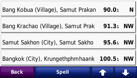
Thanks. I am referring to the province name added to all POI's address information so neither 1 or 2. Hopefully this screen shot from my Zumo explains it better: This is the listing I get when browsing cities. The three first ones are okay because they are located within provinces that have English names in the 'name' tag in the relation outlining the province. The last, Bangkok (city), is within Bangkok province. The relation for Bangkok province is properly tagged with "กรุงเทพมหานคร" in it's 'name' tag and "Bangkok" in it's 'name:en' tag. As you can see, the 'name:en' is not used but rather Thai script "Latinized". Bangkok's relation: http://ra.osmsurround.org/analyzeRelation?relationId=92277&_noCache=on# Samut Sakhon's relation: http://ra.osmsurround.org/analyzeRelation?relationId=1908816&_noCache=on# ----- Original Message ----- From: "WanMil" <wmgcnfg@web.de> To: <garvan.okeeffe.esssuap@moeys.gov.kh>; "Development list for mkgmap" <mkgmap-dev@lists.mkgmap.org.uk> Sent: Monday, June 25, 2012 4:07 PM Subject: Re: [mkgmap-dev] Province names
Nils,
after reading Garvans comment I wonder if I understood your problem correctly.
What do you mean that the province name uses that name tag instead of name:en? 1. All POIs within the province use the name tag for the province name? 2. Only the boundary itself is displayed with the name tag instead of name:en? 3. both 1. and 2.
If the answer is 1, then I have to try to reproduce the problem. Garvans comment should not be relvant to 1.
If the answer is 2, please follow Garvans hints.
WanMil
About a year ago I reported that the name tag list was not working the way I expected. I think it was not applied to relations, but I made some modifications to my style file to work around the issue. I am not sure if this is related to the problems you are having now, but I looked up the old thread for you to check out. This is the reply to my observations.
http://www.mkgmap.org.uk/pipermail/mkgmap-dev/2010q4/009593.html
Best regards,
Garvan
On 24-Jun-12 13:49, Nils Leandersson wrote:
<snip>
The final result is the same, the "name" tag is used rather than the "name:en" tag.
Can anyone confirm they can use any other name tag than the default 'name', and if so, what options was used for osmosis and mkgamp?
_______________________________________________ mkgmap-dev mailing list mkgmap-dev@lists.mkgmap.org.uk http://www.mkgmap.org.uk/mailman/listinfo/mkgmap-dev
_______________________________________________ mkgmap-dev mailing list mkgmap-dev@lists.mkgmap.org.uk http://www.mkgmap.org.uk/mailman/listinfo/mkgmap-dev
Thanks. This is similar and may have the same root cause. My issue is with the POIs within the boundaries however. I don't know what name are set for the boundaries because I don't render them with my lines style sheet. ----- Original Message ----- From: "Garvan & Maew" <garvan.okeeffe.esssuap@moeys.gov.kh> To: <mkgmap-dev@lists.mkgmap.org.uk> Sent: Monday, June 25, 2012 8:29 AM Subject: Re: [mkgmap-dev] Province names
About a year ago I reported that the name tag list was not working the way I expected. I think it was not applied to relations, but I made some modifications to my style file to work around the issue. I am not sure if this is related to the problems you are having now, but I looked up the old thread for you to check out. This is the reply to my observations.
http://www.mkgmap.org.uk/pipermail/mkgmap-dev/2010q4/009593.html
Best regards,
Garvan
On 24-Jun-12 13:49, Nils Leandersson wrote:
<snip>
The final result is the same, the "name" tag is used rather than the "name:en" tag.
Can anyone confirm they can use any other name tag than the default 'name', and if so, what options was used for osmosis and mkgamp?
_______________________________________________ mkgmap-dev mailing list mkgmap-dev@lists.mkgmap.org.uk http://www.mkgmap.org.uk/mailman/listinfo/mkgmap-dev
participants (3)
-
 Garvan & Maew
 -
 Nils Leandersson
 -
 WanMil