[Patch v4] distorted lines with make-opposite-cycleways

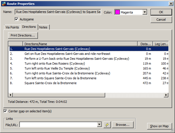
this is version 4 of the patch for this problem: http://gis.19327.n5.nabble.com/link-pois-to-ways-tags-tp5800124p5800575.html It works like version 3, but avoids to save the artificial cycle way with an id that might exist in the input file (although that is very unlikely) I am not sure if this option helps a lot. It seems that both MapSource and Basecamp have problems to find the cycle way. If I enter a route that starts on a cycle way created by this option, I am (sometimes) first forced to go onto the normal road, just to be asked to take a u-turn onto the cycleway again. This happens even if I select the switch "avoid u-turns". The attached files show that. The same problem in Basecamp. I also tried to forbid bicycle routing on ways for which an additional bicycle way is created, but found no difference. Any ideas? Gerd

Hi Gerd,
It seems that both MapSource and Basecamp have problems to find the cycle way.
There are 2 roads at the same place. Maybe img is created that way, that original road is always found first? I have observed similar problems. Then I have tested routes, which starts in a node. This way Mapsource could find cycleway but I haven't succeed in BaseCamp. I have only testes bicycle routing, maybe cycleways will work with other modes? -- Best regards, Andrzej
Hi Andrzej, maybe the order is important, but if that is the case, we would have the same problem for cars if I change the order. I also tested routes starting at normal ways, still sometimes MapSource and Basecamp avoid the cylceway and calculate detours. It would be interesting to know how Garmin maps look like in this region. An alternative to the additional way for bikes would be a route restriction for the wrong direction of the oneway with an exception for bikes and pedestrians, but that would be quite complex. Gerd popej wrote
Hi Gerd,
It seems that both MapSource and Basecamp have problems to find the cycle way.
There are 2 roads at the same place. Maybe img is created that way, that original road is always found first?
I have observed similar problems. Then I have tested routes, which starts in a node. This way Mapsource could find cycleway but I haven't succeed in BaseCamp. I have only testes bicycle routing, maybe cycleways will work with other modes?
-- Best regards, Andrzej _______________________________________________ mkgmap-dev mailing list
mkgmap-dev@.org
-- View this message in context: http://gis.19327.n5.nabble.com/Patch-v4-distorted-lines-with-make-opposite-c... Sent from the Mkgmap Development mailing list archive at Nabble.com.

Maybe you can have a look at the OSM Generic new style maps from garmin.openstreetmap.nl We dont use the option make-opposite-cycleways but process it in the style file: # make opposite cycleways highway=* & ( oneway=yes | oneway=1 | oneway=true ) & ( cycleway=opposite | cycleway=opposite_lane | cycleway=opposite_track | oneway:bicycle=no | bicycle:oneway=no ) {set oneway=no; set access=no; set bicycle=yes; set 2cycleway=1} [0x10 road_speed=1 road_class=1 continue with_actions] highway=* & oneway=-1 & 2cycleway!=1 & ( cycleway=opposite | cycleway=opposite_lane | cycleway=opposite_track | oneway:bicycle=no | bicycle:oneway=no ) {set oneway=no; set access=no; set bicycle=yes; set 2cycleway=-1} [0x10 road_speed=1 road_class=1 continue with_actions] highway=* & 2cycleway=1 {set access=yes; set oneway=1; set bicycle=no} highway=* & 2cycleway=-1 {set access=yes; set oneway=-1; set bicycle=no} Gerd wrote:
maybe the order is important, but if that is the case, we would have the same problem for cars if I change the order. I also tested routes starting at normal ways, still sometimes MapSource and Basecamp avoid the cylceway and calculate detours. It would be interesting to know how Garmin maps look like in this region. An alternative to the additional way for bikes would be a route restriction for the wrong direction of the oneway with an exception for bikes and pedestrians, but that would be quite complex.
Gerd
Hi Minko, okay, I see that the additional cycleway comes first, and that the original road is forbidden for bicycles. I think tried that already, but I'll make sure again. Gerd
Date: Tue, 25 Mar 2014 13:50:33 +0100 From: ligfietser@online.nl To: mkgmap-dev@lists.mkgmap.org.uk Subject: Re: [mkgmap-dev] [Patch v4] distorted lines with make-opposite-cycleways
Maybe you can have a look at the OSM Generic new style maps from garmin.openstreetmap.nl We dont use the option make-opposite-cycleways but process it in the style file:
# make opposite cycleways highway=* & ( oneway=yes | oneway=1 | oneway=true ) & ( cycleway=opposite | cycleway=opposite_lane | cycleway=opposite_track | oneway:bicycle=no | bicycle:oneway=no ) {set oneway=no; set access=no; set bicycle=yes; set 2cycleway=1} [0x10 road_speed=1 road_class=1 continue with_actions] highway=* & oneway=-1 & 2cycleway!=1 & ( cycleway=opposite | cycleway=opposite_lane | cycleway=opposite_track | oneway:bicycle=no | bicycle:oneway=no ) {set oneway=no; set access=no; set bicycle=yes; set 2cycleway=-1} [0x10 road_speed=1 road_class=1 continue with_actions] highway=* & 2cycleway=1 {set access=yes; set oneway=1; set bicycle=no} highway=* & 2cycleway=-1 {set access=yes; set oneway=-1; set bicycle=no}
Gerd wrote:
maybe the order is important, but if that is the case, we would have the same problem for cars if I change the order. I also tested routes starting at normal ways, still sometimes MapSource and Basecamp avoid the cylceway and calculate detours. It would be interesting to know how Garmin maps look like in this region. An alternative to the additional way for bikes would be a route restriction for the wrong direction of the oneway with an exception for bikes and pedestrians, but that would be quite complex.
Gerd
_______________________________________________ mkgmap-dev mailing list mkgmap-dev@lists.mkgmap.org.uk http://www.mkgmap.org.uk/mailman/listinfo/mkgmap-dev
Hi Gerd,
maybe the order is important, but if that is the case, we would have the same problem for cars if I change the order.
Yes, it is device which should resolve this problem. Maybe Garmin never put 2 ways at the same place?
It would be interesting to know how Garmin maps look like in this region.
No opposite cycleways on Garmin maps. Garmin offers only detours. I have tested patch-v4 and a map of Poland in BaseCamp. I have created a longer route, which can include opposite cycleway. This route is correct, it uses cycleway for bicycle and detour for cars. I think that even in bicycle mode, devices use road class and speed. And faster road is preferred over road designated as bicycle only. That makes difficult to create a map with good routing for both: cars and bicycles. Probably opposite cycleway is the best that we can have now. -- Best regards, Andrzej
participants (4)
-
 Andrzej Popowski
 -
 Gerd Petermann
 -
GerdP
-
 Minko
Minko