Commit r4470: genSea.patch by Ticker Berkin

Version mkgmap-r4470 was committed by gerd on Wed, 18 Mar 2020 genSea.patch by Ticker Berkin fixes flooded areas caused by changes in r4392 and other issues with unclosed coastlines http://www.mkgmap.org.uk/websvn/revision.php?repname=mkgmap&rev=4470

Hi Gerd & Ticker, Whilst I was testing Ticker's patch, Gerd's update was committed, so I am slightly behind the times. Both the patch and the committed code have solved almost all my coastline problems. Thanks for your efforts. I now have no tiles that are being filled with sea, but I do have one tile that is now displaying the opposite problem, in that it now displays all land and no sea with both code versions, even though there is a significant amount of sea. Please see the attached screenshot. I would have attached the tile, but it is rather large for emailing. Cheers, Mike -----Original Message----- From: svn commit [mailto:svn@mkgmap.org.uk] Sent: 18 March 2020 18:23 To: mkgmap-svn@lists.mkgmap.org.uk; mkgmap-dev@lists.mkgmap.org.uk Subject: [mkgmap-dev] Commit r4470: genSea.patch by Ticker Berkin Version mkgmap-r4470 was committed by gerd on Wed, 18 Mar 2020 genSea.patch by Ticker Berkin fixes flooded areas caused by changes in r4392 and other issues with unclosed coastlines http://www.mkgmap.org.uk/websvn/revision.php?repname=mkgmap&rev=4470

Hi Mike, please upload the tile to files.mkgmap.org.uk/ and post your generate-sea options. Gerd ________________________________________ Von: mkgmap-dev <mkgmap-dev-bounces@lists.mkgmap.org.uk> im Auftrag von Mike Baggaley <mike@tvage.co.uk> Gesendet: Freitag, 20. März 2020 00:43 An: mkgmap-dev@lists.mkgmap.org.uk Betreff: Re: [mkgmap-dev] Commit r4470: genSea.patch by Ticker Berkin Hi Gerd & Ticker, Whilst I was testing Ticker's patch, Gerd's update was committed, so I am slightly behind the times. Both the patch and the committed code have solved almost all my coastline problems. Thanks for your efforts. I now have no tiles that are being filled with sea, but I do have one tile that is now displaying the opposite problem, in that it now displays all land and no sea with both code versions, even though there is a significant amount of sea. Please see the attached screenshot. I would have attached the tile, but it is rather large for emailing. Cheers, Mike -----Original Message----- From: svn commit [mailto:svn@mkgmap.org.uk] Sent: 18 March 2020 18:23 To: mkgmap-svn@lists.mkgmap.org.uk; mkgmap-dev@lists.mkgmap.org.uk Subject: [mkgmap-dev] Commit r4470: genSea.patch by Ticker Berkin Version mkgmap-r4470 was committed by gerd on Wed, 18 Mar 2020 genSea.patch by Ticker Berkin fixes flooded areas caused by changes in r4392 and other issues with unclosed coastlines http://www.mkgmap.org.uk/websvn/revision.php?repname=mkgmap&rev=4470
Hi Gerd, I have uploaded 66973072.zip. I did not use any other options with generate-sea this time, but as mentioned in my last post, I have used them previously without them having any obvious effect. Cheers, Mike -----Original Message----- From: Gerd Petermann [mailto:gpetermann_muenchen@hotmail.com] Sent: 20 March 2020 05:51 To: mkgmap-dev@lists.mkgmap.org.uk Subject: Re: [mkgmap-dev] Commit r4470: genSea.patch by Ticker Berkin Hi Mike, please upload the tile to files.mkgmap.org.uk/ and post your generate-sea options. Gerd ________________________________________ Von: mkgmap-dev <mkgmap-dev-bounces@lists.mkgmap.org.uk> im Auftrag von Mike Baggaley <mike@tvage.co.uk> Gesendet: Freitag, 20. März 2020 00:43 An: mkgmap-dev@lists.mkgmap.org.uk Betreff: Re: [mkgmap-dev] Commit r4470: genSea.patch by Ticker Berkin Hi Gerd & Ticker, Whilst I was testing Ticker's patch, Gerd's update was committed, so I am slightly behind the times. Both the patch and the committed code have solved almost all my coastline problems. Thanks for your efforts. I now have no tiles that are being filled with sea, but I do have one tile that is now displaying the opposite problem, in that it now displays all land and no sea with both code versions, even though there is a significant amount of sea. Please see the attached screenshot. I would have attached the tile, but it is rather large for emailing. Cheers, Mike -----Original Message----- From: svn commit [mailto:svn@mkgmap.org.uk] Sent: 18 March 2020 18:23 To: mkgmap-svn@lists.mkgmap.org.uk; mkgmap-dev@lists.mkgmap.org.uk Subject: [mkgmap-dev] Commit r4470: genSea.patch by Ticker Berkin Version mkgmap-r4470 was committed by gerd on Wed, 18 Mar 2020 genSea.patch by Ticker Berkin fixes flooded areas caused by changes in r4392 and other issues with unclosed coastlines http://www.mkgmap.org.uk/websvn/revision.php?repname=mkgmap&rev=4470
Just noticed the log file has the following in it: 66973072.o5m: Adjacent coastlines hit tile edge in same direction 3.512082099914551 null 66973072.o5m: Adjacent coastlines hit tile edge in same direction 3.904301643371582 WAY: 4611686018492528634 null(50.39497375488281/-3.603515625) [] This is the offending tile, although there are other tiles showing the same message: 66973028.o5m: Adjacent coastlines hit tile edge in same direction 3.68414306640625 null 66973028.o5m: Adjacent coastlines hit tile edge in same direction 3.6845932006835938 WAY: 4611686018454067807 null(51.540770530700684/0.5712890625) [] 66973031.o5m: Adjacent coastlines hit tile edge in same direction 1.3157111273871527 null 66973031.o5m: Adjacent coastlines hit tile edge in same direction 1.5220565795898438 WAY: 4611686018456515937 null(51.62250280380249/0.5712890625) [] 66973063.o5m: Adjacent coastlines hit tile edge in same direction 0.964984130859375 null 66973063.o5m: Adjacent coastlines hit tile edge in same direction 0.968072509765625 WAY: 4611686018481807136 null(50.8447265625/-1.112666130065918) [] 66973064.o5m: Adjacent coastlines hit tile edge in same direction 2.0334129333496094 null 66973064.o5m: Adjacent coastlines hit tile edge in same direction 2.1257583618164064 WAY: 4611686018481855529 null(50.8447265625/-1.1539077758789062) [] 66973071.o5m: Adjacent coastlines hit tile edge in same direction 1.4875097274780273 null 66973071.o5m: Adjacent coastlines hit tile edge in same direction 1.493368148803711 WAY: 4611686018490569733 null(50.534770488739014/-3.603515625) [] 66973216.o5m: Adjacent coastlines hit tile edge in same direction 3.6122945149739585 null 66973216.o5m: Adjacent coastlines hit tile edge in same direction 3.6950721740722656 WAY: 4611686018642067673 null(54.13313627243042/-2.8125) [] 66973233.o5m: Adjacent coastlines hit tile edge in same direction 1.8426347620346966 null 66973233.o5m: Adjacent coastlines hit tile edge in same direction 1.9191019394818474 WAY: 4611686018657352840 null(54.21201467514038/-2.8125) [] Do these messages indicate errors in the coastline data? Regards, Mike -----Original Message----- From: Mike Baggaley [mailto:mike@tvage.co.uk] Sent: 19 March 2020 23:44 To: mkgmap-dev@lists.mkgmap.org.uk Subject: Re: [mkgmap-dev] Commit r4470: genSea.patch by Ticker Berkin Hi Gerd & Ticker, Whilst I was testing Ticker's patch, Gerd's update was committed, so I am slightly behind the times. Both the patch and the committed code have solved almost all my coastline problems. Thanks for your efforts. I now have no tiles that are being filled with sea, but I do have one tile that is now displaying the opposite problem, in that it now displays all land and no sea with both code versions, even though there is a significant amount of sea. Please see the attached screenshot. I would have attached the tile, but it is rather large for emailing. Cheers, Mike -----Original Message----- From: svn commit [mailto:svn@mkgmap.org.uk] Sent: 18 March 2020 18:23 To: mkgmap-svn@lists.mkgmap.org.uk; mkgmap-dev@lists.mkgmap.org.uk Subject: [mkgmap-dev] Commit r4470: genSea.patch by Ticker Berkin Version mkgmap-r4470 was committed by gerd on Wed, 18 Mar 2020 genSea.patch by Ticker Berkin fixes flooded areas caused by changes in r4392 and other issues with unclosed coastlines http://www.mkgmap.org.uk/websvn/revision.php?repname=mkgmap&rev=4470

Hi Mike Errors like are normally because the tile is at the edge of your downloaded area and includes incomplete coastline that doesn't reach the tile edge and/or has gaps where there are estuaries, harbours, etc. If this is not the case then there are either errors in the natural=coastline data or in the logic of SeaGenerator.java Depending on your --generate-sea options, the code tries to resolve this in different manners (sea-sectors, extend-sea-sectors, no-sea -sectors). None of these are guaranteed to work, but I tried to improve it so that it was more likely that sea was land-flooded rather than the other way around. What are you generate-sea options. I've found that: --generate-sea=multipolygon,extend-sea-sectors,close-gaps=500 works well most of the time Ticker On Fri, 2020-03-20 at 07:34 +0000, Mike Baggaley wrote:
Just noticed the log file has the following in it:
66973072.o5m: Adjacent coastlines hit tile edge in same direction 3.512082099914551 null 66973072.o5m: Adjacent coastlines hit tile edge in same direction 3.904301643371582 WAY: 4611686018492528634 null(50.39497375488281/ -3.603515625) []
This is the offending tile, although there are other tiles showing the same message:
66973028.o5m: Adjacent coastlines hit tile edge in same direction 3.68414306640625 null 66973028.o5m: Adjacent coastlines hit tile edge in same direction 3.6845932006835938 WAY: 4611686018454067807 null(51.540770530700684/0.5712890625) [] 66973031.o5m: Adjacent coastlines hit tile edge in same direction 1.3157111273871527 null 66973031.o5m: Adjacent coastlines hit tile edge in same direction 1.5220565795898438 WAY: 4611686018456515937 null(51.62250280380249/0.5712890625) [] 66973063.o5m: Adjacent coastlines hit tile edge in same direction 0.964984130859375 null 66973063.o5m: Adjacent coastlines hit tile edge in same direction 0.968072509765625 WAY: 4611686018481807136 null(50.8447265625/ -1.112666130065918) [] 66973064.o5m: Adjacent coastlines hit tile edge in same direction 2.0334129333496094 null 66973064.o5m: Adjacent coastlines hit tile edge in same direction 2.1257583618164064 WAY: 4611686018481855529 null(50.8447265625/ -1.1539077758789062) [] 66973071.o5m: Adjacent coastlines hit tile edge in same direction 1.4875097274780273 null 66973071.o5m: Adjacent coastlines hit tile edge in same direction 1.493368148803711 WAY: 4611686018490569733 null(50.534770488739014/ -3.603515625) [] 66973216.o5m: Adjacent coastlines hit tile edge in same direction 3.6122945149739585 null 66973216.o5m: Adjacent coastlines hit tile edge in same direction 3.6950721740722656 WAY: 4611686018642067673 null(54.13313627243042/ -2.8125) [] 66973233.o5m: Adjacent coastlines hit tile edge in same direction 1.8426347620346966 null 66973233.o5m: Adjacent coastlines hit tile edge in same direction 1.9191019394818474 WAY: 4611686018657352840 null(54.21201467514038/ -2.8125) []
Do these messages indicate errors in the coastline data?
Regards, Mike
-----Original Message----- From: Mike Baggaley [mailto:mike@tvage.co.uk] Sent: 19 March 2020 23:44 To: mkgmap-dev@lists.mkgmap.org.uk Subject: Re: [mkgmap-dev] Commit r4470: genSea.patch by Ticker Berkin
Hi Gerd & Ticker,
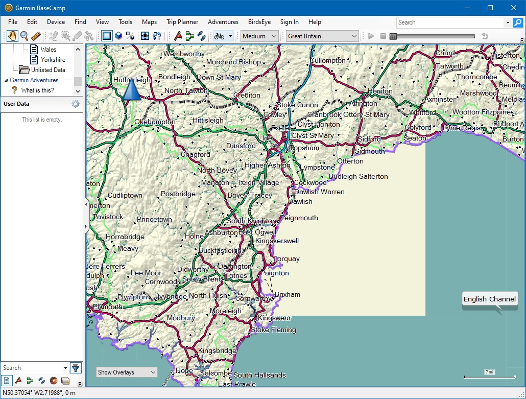
Whilst I was testing Ticker's patch, Gerd's update was committed, so I am slightly behind the times. Both the patch and the committed code have solved almost all my coastline problems. Thanks for your efforts. I now have no tiles that are being filled with sea, but I do have one tile that is now displaying the opposite problem, in that it now displays all land and no sea with both code versions, even though there is a significant amount of sea. Please see the attached screenshot. I would have attached the tile, but it is rather large for emailing.
Cheers, Mike
-----Original Message----- From: svn commit [mailto:svn@mkgmap.org.uk] Sent: 18 March 2020 18:23 To: mkgmap-svn@lists.mkgmap.org.uk; mkgmap-dev@lists.mkgmap.org.uk Subject: [mkgmap-dev] Commit r4470: genSea.patch by Ticker Berkin
Version mkgmap-r4470 was committed by gerd on Wed, 18 Mar 2020
genSea.patch by Ticker Berkin fixes flooded areas caused by changes in r4392 and other issues with unclosed coastlines
http://www.mkgmap.org.uk/websvn/revision.php?repname=mkgmap&rev=4470
_______________________________________________ mkgmap-dev mailing list mkgmap-dev@lists.mkgmap.org.uk http://www.mkgmap.org.uk/mailman/listinfo/mkgmap-dev
Hi Mike Another question: Was the image attached to the first mail a single tile? Ticker On Fri, 2020-03-20 at 09:39 +0000, Ticker Berkin wrote:
Hi Mike
Errors like are normally because the tile is at the edge of your downloaded area and includes incomplete coastline that doesn't reach the tile edge and/or has gaps where there are estuaries, harbours, etc.
If this is not the case then there are either errors in the natural=coastline data or in the logic of SeaGenerator.java
Depending on your --generate-sea options, the code tries to resolve this in different manners (sea-sectors, extend-sea-sectors, no-sea -sectors). None of these are guaranteed to work, but I tried to improve it so that it was more likely that sea was land-flooded rather than the other way around.
What are you generate-sea options. I've found that: --generate-sea=multipolygon,extend-sea-sectors,close-gaps=500 works well most of the time
Ticker
On Fri, 2020-03-20 at 07:34 +0000, Mike Baggaley wrote:
Just noticed the log file has the following in it:
66973072.o5m: Adjacent coastlines hit tile edge in same direction 3.512082099914551 null 66973072.o5m: Adjacent coastlines hit tile edge in same direction 3.904301643371582 WAY: 4611686018492528634 null(50.39497375488281/ -3.603515625) []
This is the offending tile, although there are other tiles showing the same message:
66973028.o5m: Adjacent coastlines hit tile edge in same direction 3.68414306640625 null 66973028.o5m: Adjacent coastlines hit tile edge in same direction 3.6845932006835938 WAY: 4611686018454067807 null(51.540770530700684/0.5712890625) [] 66973031.o5m: Adjacent coastlines hit tile edge in same direction 1.3157111273871527 null 66973031.o5m: Adjacent coastlines hit tile edge in same direction 1.5220565795898438 WAY: 4611686018456515937 null(51.62250280380249/0.5712890625) [] 66973063.o5m: Adjacent coastlines hit tile edge in same direction 0.964984130859375 null 66973063.o5m: Adjacent coastlines hit tile edge in same direction 0.968072509765625 WAY: 4611686018481807136 null(50.8447265625/ -1.112666130065918) [] 66973064.o5m: Adjacent coastlines hit tile edge in same direction 2.0334129333496094 null 66973064.o5m: Adjacent coastlines hit tile edge in same direction 2.1257583618164064 WAY: 4611686018481855529 null(50.8447265625/ -1.1539077758789062) [] 66973071.o5m: Adjacent coastlines hit tile edge in same direction 1.4875097274780273 null 66973071.o5m: Adjacent coastlines hit tile edge in same direction 1.493368148803711 WAY: 4611686018490569733 null(50.534770488739014/ -3.603515625) [] 66973216.o5m: Adjacent coastlines hit tile edge in same direction 3.6122945149739585 null 66973216.o5m: Adjacent coastlines hit tile edge in same direction 3.6950721740722656 WAY: 4611686018642067673 null(54.13313627243042/ -2.8125) [] 66973233.o5m: Adjacent coastlines hit tile edge in same direction 1.8426347620346966 null 66973233.o5m: Adjacent coastlines hit tile edge in same direction 1.9191019394818474 WAY: 4611686018657352840 null(54.21201467514038/ -2.8125) []
Do these messages indicate errors in the coastline data?
Regards, Mike
-----Original Message----- From: Mike Baggaley [mailto:mike@tvage.co.uk] Sent: 19 March 2020 23:44 To: mkgmap-dev@lists.mkgmap.org.uk Subject: Re: [mkgmap-dev] Commit r4470: genSea.patch by Ticker Berkin
Hi Gerd & Ticker,
Whilst I was testing Ticker's patch, Gerd's update was committed, so I am slightly behind the times. Both the patch and the committed code have solved almost all my coastline problems. Thanks for your efforts. I now have no tiles that are being filled with sea, but I do have one tile that is now displaying the opposite problem, in that it now displays all land and no sea with both code versions, even though there is a significant amount of sea. Please see the attached screenshot. I would have attached the tile, but it is rather large for emailing.
Cheers, Mike
-----Original Message----- From: svn commit [mailto:svn@mkgmap.org.uk] Sent: 18 March 2020 18:23 To: mkgmap-svn@lists.mkgmap.org.uk; mkgmap-dev@lists.mkgmap.org.uk Subject: [mkgmap-dev] Commit r4470: genSea.patch by Ticker Berkin
Version mkgmap-r4470 was committed by gerd on Wed, 18 Mar 2020
genSea.patch by Ticker Berkin fixes flooded areas caused by changes in r4392 and other issues with unclosed coastlines
http://www.mkgmap.org.uk/websvn/revision.php?repname=mkgmap&rev=447 0
_______________________________________________ mkgmap-dev mailing list mkgmap-dev@lists.mkgmap.org.uk http://www.mkgmap.org.uk/mailman/listinfo/mkgmap-dev
mkgmap-dev mailing list mkgmap-dev@lists.mkgmap.org.uk http://www.mkgmap.org.uk/mailman/listinfo/mkgmap-dev
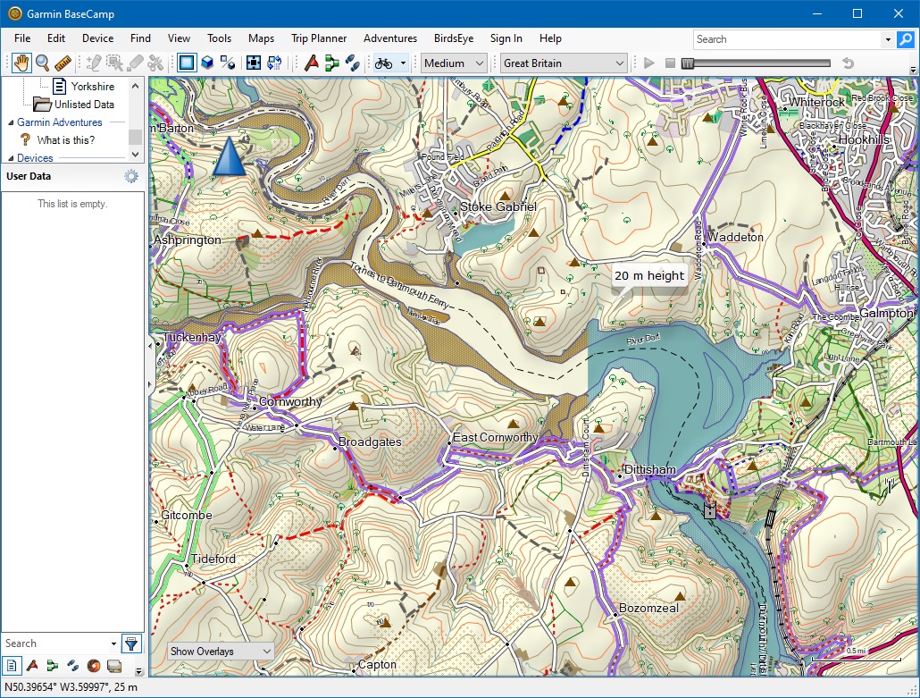
Hi Ticker, The image was contained more than a single tile - the tile I was referring to was a rectangle of which the white area was the bottom right corner. The second image shows the border between that tile (on the right) and the adjacent tile on the left. The original tile did in fact contain some sea correctly rendered in an inlet originating at Kingswear which is just on the edge of the white area. I used just generate-sea without any of the other options this time, but have used extend-sea-vectors and close-gaps without any obvious effect. I suspect that the problem with my outline is not that there are gaps, but that there may be loops where the coastline crosses itself. Regards, Mike -----Original Message----- From: Ticker Berkin [mailto:rwb-mkgmap@jagit.co.uk] Sent: 20 March 2020 09:45 To: Development list for mkgmap <mkgmap-dev@lists.mkgmap.org.uk> Subject: Re: [mkgmap-dev] Commit r4470: genSea.patch by Ticker Berkin Hi Mike Another question: Was the image attached to the first mail a single tile? Ticker On Fri, 2020-03-20 at 09:39 +0000, Ticker Berkin wrote:
Hi Mike
Errors like are normally because the tile is at the edge of your downloaded area and includes incomplete coastline that doesn't reach the tile edge and/or has gaps where there are estuaries, harbours, etc.
If this is not the case then there are either errors in the natural=coastline data or in the logic of SeaGenerator.java
Depending on your --generate-sea options, the code tries to resolve this in different manners (sea-sectors, extend-sea-sectors, no-sea -sectors). None of these are guaranteed to work, but I tried to improve it so that it was more likely that sea was land-flooded rather than the other way around.
What are you generate-sea options. I've found that: --generate-sea=multipolygon,extend-sea-sectors,close-gaps=500 works well most of the time
Ticker
On Fri, 2020-03-20 at 07:34 +0000, Mike Baggaley wrote:
Just noticed the log file has the following in it:
66973072.o5m: Adjacent coastlines hit tile edge in same direction 3.512082099914551 null 66973072.o5m: Adjacent coastlines hit tile edge in same direction 3.904301643371582 WAY: 4611686018492528634 null(50.39497375488281/ -3.603515625) []
This is the offending tile, although there are other tiles showing the same message:
66973028.o5m: Adjacent coastlines hit tile edge in same direction 3.68414306640625 null 66973028.o5m: Adjacent coastlines hit tile edge in same direction 3.6845932006835938 WAY: 4611686018454067807 null(51.540770530700684/0.5712890625) [] 66973031.o5m: Adjacent coastlines hit tile edge in same direction 1.3157111273871527 null 66973031.o5m: Adjacent coastlines hit tile edge in same direction 1.5220565795898438 WAY: 4611686018456515937 null(51.62250280380249/0.5712890625) [] 66973063.o5m: Adjacent coastlines hit tile edge in same direction 0.964984130859375 null 66973063.o5m: Adjacent coastlines hit tile edge in same direction 0.968072509765625 WAY: 4611686018481807136 null(50.8447265625/ -1.112666130065918) [] 66973064.o5m: Adjacent coastlines hit tile edge in same direction 2.0334129333496094 null 66973064.o5m: Adjacent coastlines hit tile edge in same direction 2.1257583618164064 WAY: 4611686018481855529 null(50.8447265625/ -1.1539077758789062) [] 66973071.o5m: Adjacent coastlines hit tile edge in same direction 1.4875097274780273 null 66973071.o5m: Adjacent coastlines hit tile edge in same direction 1.493368148803711 WAY: 4611686018490569733 null(50.534770488739014/ -3.603515625) [] 66973216.o5m: Adjacent coastlines hit tile edge in same direction 3.6122945149739585 null 66973216.o5m: Adjacent coastlines hit tile edge in same direction 3.6950721740722656 WAY: 4611686018642067673 null(54.13313627243042/ -2.8125) [] 66973233.o5m: Adjacent coastlines hit tile edge in same direction 1.8426347620346966 null 66973233.o5m: Adjacent coastlines hit tile edge in same direction 1.9191019394818474 WAY: 4611686018657352840 null(54.21201467514038/ -2.8125) []
Do these messages indicate errors in the coastline data?
Regards, Mike
-----Original Message----- From: Mike Baggaley [mailto:mike@tvage.co.uk] Sent: 19 March 2020 23:44 To: mkgmap-dev@lists.mkgmap.org.uk Subject: Re: [mkgmap-dev] Commit r4470: genSea.patch by Ticker Berkin
Hi Gerd & Ticker,
Whilst I was testing Ticker's patch, Gerd's update was committed, so I am slightly behind the times. Both the patch and the committed code have solved almost all my coastline problems. Thanks for your efforts. I now have no tiles that are being filled with sea, but I do have one tile that is now displaying the opposite problem, in that it now displays all land and no sea with both code versions, even though there is a significant amount of sea. Please see the attached screenshot. I would have attached the tile, but it is rather large for emailing.
Cheers, Mike
-----Original Message----- From: svn commit [mailto:svn@mkgmap.org.uk] Sent: 18 March 2020 18:23 To: mkgmap-svn@lists.mkgmap.org.uk; mkgmap-dev@lists.mkgmap.org.uk Subject: [mkgmap-dev] Commit r4470: genSea.patch by Ticker Berkin
Version mkgmap-r4470 was committed by gerd on Wed, 18 Mar 2020
genSea.patch by Ticker Berkin fixes flooded areas caused by changes in r4392 and other issues with unclosed coastlines
http://www.mkgmap.org.uk/websvn/revision.php?repname=mkgmap&rev=447 0
_______________________________________________ mkgmap-dev mailing list mkgmap-dev@lists.mkgmap.org.uk http://www.mkgmap.org.uk/mailman/listinfo/mkgmap-dev
mkgmap-dev mailing list mkgmap-dev@lists.mkgmap.org.uk http://www.mkgmap.org.uk/mailman/listinfo/mkgmap-dev
Close inspection shows a very small coast outline of an outcrop at N50.45154 W3.55078 that may not be a valid polygon, another at N50.40129 W3.49404, and another at 50.39544 W3.51977, also, possible loops in the main coastline at N50.34285 W3.56060, N50.36633 W3.57717, N50.36740 W 3.57671, N50.37806 W 3.58133, N50.34436 W3.57435 and N50.33140 W3.56933. Also, what looks like a spur at N50.70210 W3.50376. The problem seems to depend on where the tile borders are - If I delete everything except the coastline data and process that through splitter and mkgmap, there are far fewer tiles and the result looks pretty well perfect as far as I can see. Regards, Mike -----Original Message----- From: Mike Baggaley [mailto:mike@tvage.co.uk] Sent: 20 March 2020 21:35 To: 'Development list for mkgmap' <mkgmap-dev@lists.mkgmap.org.uk> Subject: RE: [mkgmap-dev] Commit r4470: genSea.patch by Ticker Berkin Hi Ticker, The image was contained more than a single tile - the tile I was referring to was a rectangle of which the white area was the bottom right corner. The second image shows the border between that tile (on the right) and the adjacent tile on the left. The original tile did in fact contain some sea correctly rendered in an inlet originating at Kingswear which is just on the edge of the white area. I used just generate-sea without any of the other options this time, but have used extend-sea-vectors and close-gaps without any obvious effect. I suspect that the problem with my outline is not that there are gaps, but that there may be loops where the coastline crosses itself. Regards, Mike -----Original Message----- From: Ticker Berkin [mailto:rwb-mkgmap@jagit.co.uk] Sent: 20 March 2020 09:45 To: Development list for mkgmap <mkgmap-dev@lists.mkgmap.org.uk> Subject: Re: [mkgmap-dev] Commit r4470: genSea.patch by Ticker Berkin Hi Mike Another question: Was the image attached to the first mail a single tile? Ticker On Fri, 2020-03-20 at 09:39 +0000, Ticker Berkin wrote:
Hi Mike
Errors like are normally because the tile is at the edge of your downloaded area and includes incomplete coastline that doesn't reach the tile edge and/or has gaps where there are estuaries, harbours, etc.
If this is not the case then there are either errors in the natural=coastline data or in the logic of SeaGenerator.java
Depending on your --generate-sea options, the code tries to resolve this in different manners (sea-sectors, extend-sea-sectors, no-sea -sectors). None of these are guaranteed to work, but I tried to improve it so that it was more likely that sea was land-flooded rather than the other way around.
What are you generate-sea options. I've found that: --generate-sea=multipolygon,extend-sea-sectors,close-gaps=500 works well most of the time
Ticker
On Fri, 2020-03-20 at 07:34 +0000, Mike Baggaley wrote:
Just noticed the log file has the following in it:
66973072.o5m: Adjacent coastlines hit tile edge in same direction 3.512082099914551 null 66973072.o5m: Adjacent coastlines hit tile edge in same direction 3.904301643371582 WAY: 4611686018492528634 null(50.39497375488281/ -3.603515625) []
This is the offending tile, although there are other tiles showing the same message:
66973028.o5m: Adjacent coastlines hit tile edge in same direction 3.68414306640625 null 66973028.o5m: Adjacent coastlines hit tile edge in same direction 3.6845932006835938 WAY: 4611686018454067807 null(51.540770530700684/0.5712890625) [] 66973031.o5m: Adjacent coastlines hit tile edge in same direction 1.3157111273871527 null 66973031.o5m: Adjacent coastlines hit tile edge in same direction 1.5220565795898438 WAY: 4611686018456515937 null(51.62250280380249/0.5712890625) [] 66973063.o5m: Adjacent coastlines hit tile edge in same direction 0.964984130859375 null 66973063.o5m: Adjacent coastlines hit tile edge in same direction 0.968072509765625 WAY: 4611686018481807136 null(50.8447265625/ -1.112666130065918) [] 66973064.o5m: Adjacent coastlines hit tile edge in same direction 2.0334129333496094 null 66973064.o5m: Adjacent coastlines hit tile edge in same direction 2.1257583618164064 WAY: 4611686018481855529 null(50.8447265625/ -1.1539077758789062) [] 66973071.o5m: Adjacent coastlines hit tile edge in same direction 1.4875097274780273 null 66973071.o5m: Adjacent coastlines hit tile edge in same direction 1.493368148803711 WAY: 4611686018490569733 null(50.534770488739014/ -3.603515625) [] 66973216.o5m: Adjacent coastlines hit tile edge in same direction 3.6122945149739585 null 66973216.o5m: Adjacent coastlines hit tile edge in same direction 3.6950721740722656 WAY: 4611686018642067673 null(54.13313627243042/ -2.8125) [] 66973233.o5m: Adjacent coastlines hit tile edge in same direction 1.8426347620346966 null 66973233.o5m: Adjacent coastlines hit tile edge in same direction 1.9191019394818474 WAY: 4611686018657352840 null(54.21201467514038/ -2.8125) []
Do these messages indicate errors in the coastline data?
Regards, Mike
-----Original Message----- From: Mike Baggaley [mailto:mike@tvage.co.uk] Sent: 19 March 2020 23:44 To: mkgmap-dev@lists.mkgmap.org.uk Subject: Re: [mkgmap-dev] Commit r4470: genSea.patch by Ticker Berkin
Hi Gerd & Ticker,
Whilst I was testing Ticker's patch, Gerd's update was committed, so I am slightly behind the times. Both the patch and the committed code have solved almost all my coastline problems. Thanks for your efforts. I now have no tiles that are being filled with sea, but I do have one tile that is now displaying the opposite problem, in that it now displays all land and no sea with both code versions, even though there is a significant amount of sea. Please see the attached screenshot. I would have attached the tile, but it is rather large for emailing.
Cheers, Mike
-----Original Message----- From: svn commit [mailto:svn@mkgmap.org.uk] Sent: 18 March 2020 18:23 To: mkgmap-svn@lists.mkgmap.org.uk; mkgmap-dev@lists.mkgmap.org.uk Subject: [mkgmap-dev] Commit r4470: genSea.patch by Ticker Berkin
Version mkgmap-r4470 was committed by gerd on Wed, 18 Mar 2020
genSea.patch by Ticker Berkin fixes flooded areas caused by changes in r4392 and other issues with unclosed coastlines
http://www.mkgmap.org.uk/websvn/revision.php?repname=mkgmap&rev=447 0
_______________________________________________ mkgmap-dev mailing list mkgmap-dev@lists.mkgmap.org.uk http://www.mkgmap.org.uk/mailman/listinfo/mkgmap-dev
mkgmap-dev mailing list mkgmap-dev@lists.mkgmap.org.uk http://www.mkgmap.org.uk/mailman/listinfo/mkgmap-dev
Hi Mike, I cannot reproduce the problem with r4473 and your file and option --generate-sea=multipolygon. I can reproduce it with option --generate-sea=polygon, but that option is not recommended AFAIK. Gerd ________________________________________ Von: mkgmap-dev <mkgmap-dev-bounces@lists.mkgmap.org.uk> im Auftrag von Mike Baggaley <mike@tvage.co.uk> Gesendet: Freitag, 20. März 2020 23:18 An: 'Development list for mkgmap' Betreff: Re: [mkgmap-dev] Commit r4470: genSea.patch by Ticker Berkin Close inspection shows a very small coast outline of an outcrop at N50.45154 W3.55078 that may not be a valid polygon, another at N50.40129 W3.49404, and another at 50.39544 W3.51977, also, possible loops in the main coastline at N50.34285 W3.56060, N50.36633 W3.57717, N50.36740 W 3.57671, N50.37806 W 3.58133, N50.34436 W3.57435 and N50.33140 W3.56933. Also, what looks like a spur at N50.70210 W3.50376. The problem seems to depend on where the tile borders are - If I delete everything except the coastline data and process that through splitter and mkgmap, there are far fewer tiles and the result looks pretty well perfect as far as I can see. Regards, Mike -----Original Message----- From: Mike Baggaley [mailto:mike@tvage.co.uk] Sent: 20 March 2020 21:35 To: 'Development list for mkgmap' <mkgmap-dev@lists.mkgmap.org.uk> Subject: RE: [mkgmap-dev] Commit r4470: genSea.patch by Ticker Berkin Hi Ticker, The image was contained more than a single tile - the tile I was referring to was a rectangle of which the white area was the bottom right corner. The second image shows the border between that tile (on the right) and the adjacent tile on the left. The original tile did in fact contain some sea correctly rendered in an inlet originating at Kingswear which is just on the edge of the white area. I used just generate-sea without any of the other options this time, but have used extend-sea-vectors and close-gaps without any obvious effect. I suspect that the problem with my outline is not that there are gaps, but that there may be loops where the coastline crosses itself. Regards, Mike -----Original Message----- From: Ticker Berkin [mailto:rwb-mkgmap@jagit.co.uk] Sent: 20 March 2020 09:45 To: Development list for mkgmap <mkgmap-dev@lists.mkgmap.org.uk> Subject: Re: [mkgmap-dev] Commit r4470: genSea.patch by Ticker Berkin Hi Mike Another question: Was the image attached to the first mail a single tile? Ticker On Fri, 2020-03-20 at 09:39 +0000, Ticker Berkin wrote:
Hi Mike
Errors like are normally because the tile is at the edge of your downloaded area and includes incomplete coastline that doesn't reach the tile edge and/or has gaps where there are estuaries, harbours, etc.
If this is not the case then there are either errors in the natural=coastline data or in the logic of SeaGenerator.java
Depending on your --generate-sea options, the code tries to resolve this in different manners (sea-sectors, extend-sea-sectors, no-sea -sectors). None of these are guaranteed to work, but I tried to improve it so that it was more likely that sea was land-flooded rather than the other way around.
What are you generate-sea options. I've found that: --generate-sea=multipolygon,extend-sea-sectors,close-gaps=500 works well most of the time
Ticker
On Fri, 2020-03-20 at 07:34 +0000, Mike Baggaley wrote:
Just noticed the log file has the following in it:
66973072.o5m: Adjacent coastlines hit tile edge in same direction 3.512082099914551 null 66973072.o5m: Adjacent coastlines hit tile edge in same direction 3.904301643371582 WAY: 4611686018492528634 null(50.39497375488281/ -3.603515625) []
This is the offending tile, although there are other tiles showing the same message:
66973028.o5m: Adjacent coastlines hit tile edge in same direction 3.68414306640625 null 66973028.o5m: Adjacent coastlines hit tile edge in same direction 3.6845932006835938 WAY: 4611686018454067807 null(51.540770530700684/0.5712890625) [] 66973031.o5m: Adjacent coastlines hit tile edge in same direction 1.3157111273871527 null 66973031.o5m: Adjacent coastlines hit tile edge in same direction 1.5220565795898438 WAY: 4611686018456515937 null(51.62250280380249/0.5712890625) [] 66973063.o5m: Adjacent coastlines hit tile edge in same direction 0.964984130859375 null 66973063.o5m: Adjacent coastlines hit tile edge in same direction 0.968072509765625 WAY: 4611686018481807136 null(50.8447265625/ -1.112666130065918) [] 66973064.o5m: Adjacent coastlines hit tile edge in same direction 2.0334129333496094 null 66973064.o5m: Adjacent coastlines hit tile edge in same direction 2.1257583618164064 WAY: 4611686018481855529 null(50.8447265625/ -1.1539077758789062) [] 66973071.o5m: Adjacent coastlines hit tile edge in same direction 1.4875097274780273 null 66973071.o5m: Adjacent coastlines hit tile edge in same direction 1.493368148803711 WAY: 4611686018490569733 null(50.534770488739014/ -3.603515625) [] 66973216.o5m: Adjacent coastlines hit tile edge in same direction 3.6122945149739585 null 66973216.o5m: Adjacent coastlines hit tile edge in same direction 3.6950721740722656 WAY: 4611686018642067673 null(54.13313627243042/ -2.8125) [] 66973233.o5m: Adjacent coastlines hit tile edge in same direction 1.8426347620346966 null 66973233.o5m: Adjacent coastlines hit tile edge in same direction 1.9191019394818474 WAY: 4611686018657352840 null(54.21201467514038/ -2.8125) []
Do these messages indicate errors in the coastline data?
Regards, Mike
-----Original Message----- From: Mike Baggaley [mailto:mike@tvage.co.uk] Sent: 19 March 2020 23:44 To: mkgmap-dev@lists.mkgmap.org.uk Subject: Re: [mkgmap-dev] Commit r4470: genSea.patch by Ticker Berkin
Hi Gerd & Ticker,
Whilst I was testing Ticker's patch, Gerd's update was committed, so I am slightly behind the times. Both the patch and the committed code have solved almost all my coastline problems. Thanks for your efforts. I now have no tiles that are being filled with sea, but I do have one tile that is now displaying the opposite problem, in that it now displays all land and no sea with both code versions, even though there is a significant amount of sea. Please see the attached screenshot. I would have attached the tile, but it is rather large for emailing.
Cheers, Mike
-----Original Message----- From: svn commit [mailto:svn@mkgmap.org.uk] Sent: 18 March 2020 18:23 To: mkgmap-svn@lists.mkgmap.org.uk; mkgmap-dev@lists.mkgmap.org.uk Subject: [mkgmap-dev] Commit r4470: genSea.patch by Ticker Berkin
Version mkgmap-r4470 was committed by gerd on Wed, 18 Mar 2020
genSea.patch by Ticker Berkin fixes flooded areas caused by changes in r4392 and other issues with unclosed coastlines
http://www.mkgmap.org.uk/websvn/revision.php?repname=mkgmap&rev=447 0
_______________________________________________ mkgmap-dev mailing list mkgmap-dev@lists.mkgmap.org.uk http://www.mkgmap.org.uk/mailman/listinfo/mkgmap-dev
mkgmap-dev mailing list mkgmap-dev@lists.mkgmap.org.uk http://www.mkgmap.org.uk/mailman/listinfo/mkgmap-dev
_______________________________________________ mkgmap-dev mailing list mkgmap-dev@lists.mkgmap.org.uk http://www.mkgmap.org.uk/mailman/listinfo/mkgmap-dev
Hi Mike, Gerd I've also built 66973072.o5m from http://files.mkgmap.org.uk/download/463/66973072.zip and don't get any of the messages about the coastline hitting tile edge in the same direction. With --generate-sea=multipolygon it look correct. With --generate-sea=polygon it requires more in the style and .typ fileto get the land to show over the sea because this mode generates a polygon tagged natural=sea covering the full tile and then, for each but of land, a polygon tagged with --land-tag (default natural=land) Ticker On Sat, 2020-03-21 at 08:44 +0000, Gerd Petermann wrote:
Hi Mike,
I cannot reproduce the problem with r4473 and your file and option - -generate-sea=multipolygon. I can reproduce it with option --generate-sea=polygon, but that option is not recommended AFAIK.
Gerd
________________________________________ Von: mkgmap-dev <mkgmap-dev-bounces@lists.mkgmap.org.uk> im Auftrag von Mike Baggaley <mike@tvage.co.uk> Gesendet: Freitag, 20. März 2020 23:18 An: 'Development list for mkgmap' Betreff: Re: [mkgmap-dev] Commit r4470: genSea.patch by Ticker Berkin
Close inspection shows a very small coast outline of an outcrop at N50.45154 W3.55078 that may not be a valid polygon, another at N50.40129 W3.49404, and another at 50.39544 W3.51977, also, possible loops in the main coastline at N50.34285 W3.56060, N50.36633 W3.57717, N50.36740 W 3.57671, N50.37806 W 3.58133, N50.34436 W3.57435 and N50.33140 W3.56933. Also, what looks like a spur at N50.70210 W3.50376. The problem seems to depend on where the tile borders are - If I delete everything except the coastline data and process that through splitter and mkgmap, there are far fewer tiles and the result looks pretty well perfect as far as I can see.
Regards, Mike
-----Original Message----- From: Mike Baggaley [mailto:mike@tvage.co.uk] Sent: 20 March 2020 21:35 To: 'Development list for mkgmap' <mkgmap-dev@lists.mkgmap.org.uk> Subject: RE: [mkgmap-dev] Commit r4470: genSea.patch by Ticker Berkin
Hi Ticker,
The image was contained more than a single tile - the tile I was referring to was a rectangle of which the white area was the bottom right corner. The second image shows the border between that tile (on the right) and the adjacent tile on the left. The original tile did in fact contain some sea correctly rendered in an inlet originating at Kingswear which is just on the edge of the white area.
I used just generate-sea without any of the other options this time, but have used extend-sea-vectors and close-gaps without any obvious effect. I suspect that the problem with my outline is not that there are gaps, but that there may be loops where the coastline crosses itself.
Regards, Mike
-----Original Message----- From: Ticker Berkin [mailto:rwb-mkgmap@jagit.co.uk] Sent: 20 March 2020 09:45 To: Development list for mkgmap <mkgmap-dev@lists.mkgmap.org.uk> Subject: Re: [mkgmap-dev] Commit r4470: genSea.patch by Ticker Berkin
Hi Mike
Another question:
Was the image attached to the first mail a single tile?
Ticker
On Fri, 2020-03-20 at 09:39 +0000, Ticker Berkin wrote:
Hi Mike
Errors like are normally because the tile is at the edge of your downloaded area and includes incomplete coastline that doesn't reach the tile edge and/or has gaps where there are estuaries, harbours, etc.
If this is not the case then there are either errors in the natural=coastline data or in the logic of SeaGenerator.java
Depending on your --generate-sea options, the code tries to resolve this in different manners (sea-sectors, extend-sea-sectors, no-sea -sectors). None of these are guaranteed to work, but I tried to improve it so that it was more likely that sea was land-flooded rather than the other way around.
What are you generate-sea options. I've found that: --generate-sea=multipolygon,extend-sea-sectors,close-gaps=500 works well most of the time
Ticker
On Fri, 2020-03-20 at 07:34 +0000, Mike Baggaley wrote:
Just noticed the log file has the following in it:
66973072.o5m: Adjacent coastlines hit tile edge in same direction 3.512082099914551 null 66973072.o5m: Adjacent coastlines hit tile edge in same direction 3.904301643371582 WAY: 4611686018492528634 null(50.39497375488281/ -3.603515625) []
This is the offending tile, although there are other tiles showing the same message:
66973028.o5m: Adjacent coastlines hit tile edge in same direction 3.68414306640625 null 66973028.o5m: Adjacent coastlines hit tile edge in same direction 3.6845932006835938 WAY: 4611686018454067807 null(51.540770530700684/0.5712890625) [] 66973031.o5m: Adjacent coastlines hit tile edge in same direction 1.3157111273871527 null 66973031.o5m: Adjacent coastlines hit tile edge in same direction 1.5220565795898438 WAY: 4611686018456515937 null(51.62250280380249/0.5712890625) [] 66973063.o5m: Adjacent coastlines hit tile edge in same direction 0.964984130859375 null 66973063.o5m: Adjacent coastlines hit tile edge in same direction 0.968072509765625 WAY: 4611686018481807136 null(50.8447265625/ -1.112666130065918) [] 66973064.o5m: Adjacent coastlines hit tile edge in same direction 2.0334129333496094 null 66973064.o5m: Adjacent coastlines hit tile edge in same direction 2.1257583618164064 WAY: 4611686018481855529 null(50.8447265625/ -1.1539077758789062) [] 66973071.o5m: Adjacent coastlines hit tile edge in same direction 1.4875097274780273 null 66973071.o5m: Adjacent coastlines hit tile edge in same direction 1.493368148803711 WAY: 4611686018490569733 null(50.534770488739014/ -3.603515625) [] 66973216.o5m: Adjacent coastlines hit tile edge in same direction 3.6122945149739585 null 66973216.o5m: Adjacent coastlines hit tile edge in same direction 3.6950721740722656 WAY: 4611686018642067673 null(54.13313627243042/ -2.8125) [] 66973233.o5m: Adjacent coastlines hit tile edge in same direction 1.8426347620346966 null 66973233.o5m: Adjacent coastlines hit tile edge in same direction 1.9191019394818474 WAY: 4611686018657352840 null(54.21201467514038/ -2.8125) []
Do these messages indicate errors in the coastline data?
Regards, Mike
-----Original Message----- From: Mike Baggaley [mailto:mike@tvage.co.uk] Sent: 19 March 2020 23:44 To: mkgmap-dev@lists.mkgmap.org.uk Subject: Re: [mkgmap-dev] Commit r4470: genSea.patch by Ticker Berkin
Hi Gerd & Ticker,
Whilst I was testing Ticker's patch, Gerd's update was committed, so I am slightly behind the times. Both the patch and the committed code have solved almost all my coastline problems. Thanks for your efforts. I now have no tiles that are being filled with sea, but I do have one tile that is now displaying the opposite problem, in that it now displays all land and no sea with both code versions, even though there is a significant amount of sea. Please see the attached screenshot. I would have attached the tile, but it is rather large for emailing.
Cheers, Mike
-----Original Message----- From: svn commit [mailto:svn@mkgmap.org.uk] Sent: 18 March 2020 18:23 To: mkgmap-svn@lists.mkgmap.org.uk; mkgmap-dev@lists.mkgmap.org.uk Subject: [mkgmap-dev] Commit r4470: genSea.patch by Ticker Berkin
Version mkgmap-r4470 was committed by gerd on Wed, 18 Mar 2020
genSea.patch by Ticker Berkin fixes flooded areas caused by changes in r4392 and other issues with unclosed coastlines
http://www.mkgmap.org.uk/websvn/revision.php?repname=mkgmap&rev=4 47 0
_______________________________________________ mkgmap-dev mailing list mkgmap-dev@lists.mkgmap.org.uk http://www.mkgmap.org.uk/mailman/listinfo/mkgmap-dev
mkgmap-dev mailing list mkgmap-dev@lists.mkgmap.org.uk http://www.mkgmap.org.uk/mailman/listinfo/mkgmap-dev
_______________________________________________ mkgmap-dev mailing list mkgmap-dev@lists.mkgmap.org.uk http://www.mkgmap.org.uk/mailman/listinfo/mkgmap-dev _______________________________________________ mkgmap-dev mailing list mkgmap-dev@lists.mkgmap.org.uk http://www.mkgmap.org.uk/mailman/listinfo/mkgmap-dev
Hi Gerd & Ticker, Please accept my apologies - I forgot that the coastline data I was using would not be in the tile data because I have a --coastlinefile option in my command arguments. I have uploaded the coastline file now. Regards, Mike -----Original Message----- From: Gerd Petermann [mailto:gpetermann_muenchen@hotmail.com] Sent: 21 March 2020 08:45 To: 'Development list for mkgmap' <mkgmap-dev@lists.mkgmap.org.uk> Subject: Re: [mkgmap-dev] Commit r4470: genSea.patch by Ticker Berkin Hi Mike, I cannot reproduce the problem with r4473 and your file and option --generate-sea=multipolygon. I can reproduce it with option --generate-sea=polygon, but that option is not recommended AFAIK. Gerd ________________________________________ Von: mkgmap-dev <mkgmap-dev-bounces@lists.mkgmap.org.uk> im Auftrag von Mike Baggaley <mike@tvage.co.uk> Gesendet: Freitag, 20. März 2020 23:18 An: 'Development list for mkgmap' Betreff: Re: [mkgmap-dev] Commit r4470: genSea.patch by Ticker Berkin Close inspection shows a very small coast outline of an outcrop at N50.45154 W3.55078 that may not be a valid polygon, another at N50.40129 W3.49404, and another at 50.39544 W3.51977, also, possible loops in the main coastline at N50.34285 W3.56060, N50.36633 W3.57717, N50.36740 W 3.57671, N50.37806 W 3.58133, N50.34436 W3.57435 and N50.33140 W3.56933. Also, what looks like a spur at N50.70210 W3.50376. The problem seems to depend on where the tile borders are - If I delete everything except the coastline data and process that through splitter and mkgmap, there are far fewer tiles and the result looks pretty well perfect as far as I can see. Regards, Mike -----Original Message----- From: Mike Baggaley [mailto:mike@tvage.co.uk] Sent: 20 March 2020 21:35 To: 'Development list for mkgmap' <mkgmap-dev@lists.mkgmap.org.uk> Subject: RE: [mkgmap-dev] Commit r4470: genSea.patch by Ticker Berkin Hi Ticker, The image was contained more than a single tile - the tile I was referring to was a rectangle of which the white area was the bottom right corner. The second image shows the border between that tile (on the right) and the adjacent tile on the left. The original tile did in fact contain some sea correctly rendered in an inlet originating at Kingswear which is just on the edge of the white area. I used just generate-sea without any of the other options this time, but have used extend-sea-vectors and close-gaps without any obvious effect. I suspect that the problem with my outline is not that there are gaps, but that there may be loops where the coastline crosses itself. Regards, Mike -----Original Message----- From: Ticker Berkin [mailto:rwb-mkgmap@jagit.co.uk] Sent: 20 March 2020 09:45 To: Development list for mkgmap <mkgmap-dev@lists.mkgmap.org.uk> Subject: Re: [mkgmap-dev] Commit r4470: genSea.patch by Ticker Berkin Hi Mike Another question: Was the image attached to the first mail a single tile? Ticker On Fri, 2020-03-20 at 09:39 +0000, Ticker Berkin wrote:
Hi Mike
Errors like are normally because the tile is at the edge of your downloaded area and includes incomplete coastline that doesn't reach the tile edge and/or has gaps where there are estuaries, harbours, etc.
If this is not the case then there are either errors in the natural=coastline data or in the logic of SeaGenerator.java
Depending on your --generate-sea options, the code tries to resolve this in different manners (sea-sectors, extend-sea-sectors, no-sea -sectors). None of these are guaranteed to work, but I tried to improve it so that it was more likely that sea was land-flooded rather than the other way around.
What are you generate-sea options. I've found that: --generate-sea=multipolygon,extend-sea-sectors,close-gaps=500 works well most of the time
Ticker
On Fri, 2020-03-20 at 07:34 +0000, Mike Baggaley wrote:
Just noticed the log file has the following in it:
66973072.o5m: Adjacent coastlines hit tile edge in same direction 3.512082099914551 null 66973072.o5m: Adjacent coastlines hit tile edge in same direction 3.904301643371582 WAY: 4611686018492528634 null(50.39497375488281/ -3.603515625) []
This is the offending tile, although there are other tiles showing the same message:
66973028.o5m: Adjacent coastlines hit tile edge in same direction 3.68414306640625 null 66973028.o5m: Adjacent coastlines hit tile edge in same direction 3.6845932006835938 WAY: 4611686018454067807 null(51.540770530700684/0.5712890625) [] 66973031.o5m: Adjacent coastlines hit tile edge in same direction 1.3157111273871527 null 66973031.o5m: Adjacent coastlines hit tile edge in same direction 1.5220565795898438 WAY: 4611686018456515937 null(51.62250280380249/0.5712890625) [] 66973063.o5m: Adjacent coastlines hit tile edge in same direction 0.964984130859375 null 66973063.o5m: Adjacent coastlines hit tile edge in same direction 0.968072509765625 WAY: 4611686018481807136 null(50.8447265625/ -1.112666130065918) [] 66973064.o5m: Adjacent coastlines hit tile edge in same direction 2.0334129333496094 null 66973064.o5m: Adjacent coastlines hit tile edge in same direction 2.1257583618164064 WAY: 4611686018481855529 null(50.8447265625/ -1.1539077758789062) [] 66973071.o5m: Adjacent coastlines hit tile edge in same direction 1.4875097274780273 null 66973071.o5m: Adjacent coastlines hit tile edge in same direction 1.493368148803711 WAY: 4611686018490569733 null(50.534770488739014/ -3.603515625) [] 66973216.o5m: Adjacent coastlines hit tile edge in same direction 3.6122945149739585 null 66973216.o5m: Adjacent coastlines hit tile edge in same direction 3.6950721740722656 WAY: 4611686018642067673 null(54.13313627243042/ -2.8125) [] 66973233.o5m: Adjacent coastlines hit tile edge in same direction 1.8426347620346966 null 66973233.o5m: Adjacent coastlines hit tile edge in same direction 1.9191019394818474 WAY: 4611686018657352840 null(54.21201467514038/ -2.8125) []
Do these messages indicate errors in the coastline data?
Regards, Mike
-----Original Message----- From: Mike Baggaley [mailto:mike@tvage.co.uk] Sent: 19 March 2020 23:44 To: mkgmap-dev@lists.mkgmap.org.uk Subject: Re: [mkgmap-dev] Commit r4470: genSea.patch by Ticker Berkin
Hi Gerd & Ticker,
Whilst I was testing Ticker's patch, Gerd's update was committed, so I am slightly behind the times. Both the patch and the committed code have solved almost all my coastline problems. Thanks for your efforts. I now have no tiles that are being filled with sea, but I do have one tile that is now displaying the opposite problem, in that it now displays all land and no sea with both code versions, even though there is a significant amount of sea. Please see the attached screenshot. I would have attached the tile, but it is rather large for emailing.
Cheers, Mike
-----Original Message----- From: svn commit [mailto:svn@mkgmap.org.uk] Sent: 18 March 2020 18:23 To: mkgmap-svn@lists.mkgmap.org.uk; mkgmap-dev@lists.mkgmap.org.uk Subject: [mkgmap-dev] Commit r4470: genSea.patch by Ticker Berkin
Version mkgmap-r4470 was committed by gerd on Wed, 18 Mar 2020
genSea.patch by Ticker Berkin fixes flooded areas caused by changes in r4392 and other issues with unclosed coastlines
http://www.mkgmap.org.uk/websvn/revision.php?repname=mkgmap&rev=447 0
_______________________________________________ mkgmap-dev mailing list mkgmap-dev@lists.mkgmap.org.uk http://www.mkgmap.org.uk/mailman/listinfo/mkgmap-dev
mkgmap-dev mailing list mkgmap-dev@lists.mkgmap.org.uk http://www.mkgmap.org.uk/mailman/listinfo/mkgmap-dev
_______________________________________________ mkgmap-dev mailing list mkgmap-dev@lists.mkgmap.org.uk http://www.mkgmap.org.uk/mailman/listinfo/mkgmap-dev
Hi Mike, took me a while to load the file into JOSM. The file contains lots of errors, how is it produced? I doubt that the real coastline data is as bad as this. JOSM validator finds lots of duplicated nodes, 1673 ways with "Reversed coastline: land not on left side", and 859 "Crossing ways". Gerd ________________________________________ Von: mkgmap-dev <mkgmap-dev-bounces@lists.mkgmap.org.uk> im Auftrag von Mike Baggaley <mike@tvage.co.uk> Gesendet: Samstag, 21. März 2020 23:13 An: 'Development list for mkgmap' Betreff: Re: [mkgmap-dev] Commit r4470: genSea.patch by Ticker Berkin Hi Gerd & Ticker, Please accept my apologies - I forgot that the coastline data I was using would not be in the tile data because I have a --coastlinefile option in my command arguments. I have uploaded the coastline file now. Regards, Mike -----Original Message----- From: Gerd Petermann [mailto:gpetermann_muenchen@hotmail.com] Sent: 21 March 2020 08:45 To: 'Development list for mkgmap' <mkgmap-dev@lists.mkgmap.org.uk> Subject: Re: [mkgmap-dev] Commit r4470: genSea.patch by Ticker Berkin Hi Mike, I cannot reproduce the problem with r4473 and your file and option --generate-sea=multipolygon. I can reproduce it with option --generate-sea=polygon, but that option is not recommended AFAIK. Gerd ________________________________________ Von: mkgmap-dev <mkgmap-dev-bounces@lists.mkgmap.org.uk> im Auftrag von Mike Baggaley <mike@tvage.co.uk> Gesendet: Freitag, 20. März 2020 23:18 An: 'Development list for mkgmap' Betreff: Re: [mkgmap-dev] Commit r4470: genSea.patch by Ticker Berkin Close inspection shows a very small coast outline of an outcrop at N50.45154 W3.55078 that may not be a valid polygon, another at N50.40129 W3.49404, and another at 50.39544 W3.51977, also, possible loops in the main coastline at N50.34285 W3.56060, N50.36633 W3.57717, N50.36740 W 3.57671, N50.37806 W 3.58133, N50.34436 W3.57435 and N50.33140 W3.56933. Also, what looks like a spur at N50.70210 W3.50376. The problem seems to depend on where the tile borders are - If I delete everything except the coastline data and process that through splitter and mkgmap, there are far fewer tiles and the result looks pretty well perfect as far as I can see. Regards, Mike -----Original Message----- From: Mike Baggaley [mailto:mike@tvage.co.uk] Sent: 20 March 2020 21:35 To: 'Development list for mkgmap' <mkgmap-dev@lists.mkgmap.org.uk> Subject: RE: [mkgmap-dev] Commit r4470: genSea.patch by Ticker Berkin Hi Ticker, The image was contained more than a single tile - the tile I was referring to was a rectangle of which the white area was the bottom right corner. The second image shows the border between that tile (on the right) and the adjacent tile on the left. The original tile did in fact contain some sea correctly rendered in an inlet originating at Kingswear which is just on the edge of the white area. I used just generate-sea without any of the other options this time, but have used extend-sea-vectors and close-gaps without any obvious effect. I suspect that the problem with my outline is not that there are gaps, but that there may be loops where the coastline crosses itself. Regards, Mike -----Original Message----- From: Ticker Berkin [mailto:rwb-mkgmap@jagit.co.uk] Sent: 20 March 2020 09:45 To: Development list for mkgmap <mkgmap-dev@lists.mkgmap.org.uk> Subject: Re: [mkgmap-dev] Commit r4470: genSea.patch by Ticker Berkin Hi Mike Another question: Was the image attached to the first mail a single tile? Ticker On Fri, 2020-03-20 at 09:39 +0000, Ticker Berkin wrote:
Hi Mike
Errors like are normally because the tile is at the edge of your downloaded area and includes incomplete coastline that doesn't reach the tile edge and/or has gaps where there are estuaries, harbours, etc.
If this is not the case then there are either errors in the natural=coastline data or in the logic of SeaGenerator.java
Depending on your --generate-sea options, the code tries to resolve this in different manners (sea-sectors, extend-sea-sectors, no-sea -sectors). None of these are guaranteed to work, but I tried to improve it so that it was more likely that sea was land-flooded rather than the other way around.
What are you generate-sea options. I've found that: --generate-sea=multipolygon,extend-sea-sectors,close-gaps=500 works well most of the time
Ticker
On Fri, 2020-03-20 at 07:34 +0000, Mike Baggaley wrote:
Just noticed the log file has the following in it:
66973072.o5m: Adjacent coastlines hit tile edge in same direction 3.512082099914551 null 66973072.o5m: Adjacent coastlines hit tile edge in same direction 3.904301643371582 WAY: 4611686018492528634 null(50.39497375488281/ -3.603515625) []
This is the offending tile, although there are other tiles showing the same message:
66973028.o5m: Adjacent coastlines hit tile edge in same direction 3.68414306640625 null 66973028.o5m: Adjacent coastlines hit tile edge in same direction 3.6845932006835938 WAY: 4611686018454067807 null(51.540770530700684/0.5712890625) [] 66973031.o5m: Adjacent coastlines hit tile edge in same direction 1.3157111273871527 null 66973031.o5m: Adjacent coastlines hit tile edge in same direction 1.5220565795898438 WAY: 4611686018456515937 null(51.62250280380249/0.5712890625) [] 66973063.o5m: Adjacent coastlines hit tile edge in same direction 0.964984130859375 null 66973063.o5m: Adjacent coastlines hit tile edge in same direction 0.968072509765625 WAY: 4611686018481807136 null(50.8447265625/ -1.112666130065918) [] 66973064.o5m: Adjacent coastlines hit tile edge in same direction 2.0334129333496094 null 66973064.o5m: Adjacent coastlines hit tile edge in same direction 2.1257583618164064 WAY: 4611686018481855529 null(50.8447265625/ -1.1539077758789062) [] 66973071.o5m: Adjacent coastlines hit tile edge in same direction 1.4875097274780273 null 66973071.o5m: Adjacent coastlines hit tile edge in same direction 1.493368148803711 WAY: 4611686018490569733 null(50.534770488739014/ -3.603515625) [] 66973216.o5m: Adjacent coastlines hit tile edge in same direction 3.6122945149739585 null 66973216.o5m: Adjacent coastlines hit tile edge in same direction 3.6950721740722656 WAY: 4611686018642067673 null(54.13313627243042/ -2.8125) [] 66973233.o5m: Adjacent coastlines hit tile edge in same direction 1.8426347620346966 null 66973233.o5m: Adjacent coastlines hit tile edge in same direction 1.9191019394818474 WAY: 4611686018657352840 null(54.21201467514038/ -2.8125) []
Do these messages indicate errors in the coastline data?
Regards, Mike
-----Original Message----- From: Mike Baggaley [mailto:mike@tvage.co.uk] Sent: 19 March 2020 23:44 To: mkgmap-dev@lists.mkgmap.org.uk Subject: Re: [mkgmap-dev] Commit r4470: genSea.patch by Ticker Berkin
Hi Gerd & Ticker,
Whilst I was testing Ticker's patch, Gerd's update was committed, so I am slightly behind the times. Both the patch and the committed code have solved almost all my coastline problems. Thanks for your efforts. I now have no tiles that are being filled with sea, but I do have one tile that is now displaying the opposite problem, in that it now displays all land and no sea with both code versions, even though there is a significant amount of sea. Please see the attached screenshot. I would have attached the tile, but it is rather large for emailing.
Cheers, Mike
-----Original Message----- From: svn commit [mailto:svn@mkgmap.org.uk] Sent: 18 March 2020 18:23 To: mkgmap-svn@lists.mkgmap.org.uk; mkgmap-dev@lists.mkgmap.org.uk Subject: [mkgmap-dev] Commit r4470: genSea.patch by Ticker Berkin
Version mkgmap-r4470 was committed by gerd on Wed, 18 Mar 2020
genSea.patch by Ticker Berkin fixes flooded areas caused by changes in r4392 and other issues with unclosed coastlines
http://www.mkgmap.org.uk/websvn/revision.php?repname=mkgmap&rev=447 0
_______________________________________________ mkgmap-dev mailing list mkgmap-dev@lists.mkgmap.org.uk http://www.mkgmap.org.uk/mailman/listinfo/mkgmap-dev
mkgmap-dev mailing list mkgmap-dev@lists.mkgmap.org.uk http://www.mkgmap.org.uk/mailman/listinfo/mkgmap-dev
_______________________________________________ mkgmap-dev mailing list mkgmap-dev@lists.mkgmap.org.uk http://www.mkgmap.org.uk/mailman/listinfo/mkgmap-dev _______________________________________________ mkgmap-dev mailing list mkgmap-dev@lists.mkgmap.org.uk http://www.mkgmap.org.uk/mailman/listinfo/mkgmap-dev
Hi Mike Also, why are you using this? If --generate-sea=... (without --coastlinefile) is having problems around your map edge because of incomplete coastlines, the better solution is to use --precomp-sea=sea.zip instead; where sea.zip is downloaded from link on the mkgmap site. whatever the source of the data for generate-sea, it the tile edge cuts through a loop or crossing coastlines, or a bit of coastline goes in the wrong direction, it might produce errors like: "Adjacent coastlines hit tile edge in same direction" and flood the land or drain the sea. Incomplete coastlines because they are outside the downloaded area, but included in a tile might be impossible for --generate-sea to resolve, but the options close-gaps, sea-sectors and extend-sea-sectors might give a reasonable of the land/sea Ticker On Sun, 2020-03-22 at 09:52 +0000, Gerd Petermann wrote:
Hi Mike,
took me a while to load the file into JOSM. The file contains lots of errors, how is it produced? I doubt that the real coastline data is as bad as this. JOSM validator finds lots of duplicated nodes, 1673 ways with "Reversed coastline: land not on left side", and 859 "Crossing ways".
Gerd
________________________________________ Von: mkgmap-dev <mkgmap-dev-bounces@lists.mkgmap.org.uk> im Auftrag von Mike Baggaley <mike@tvage.co.uk> Gesendet: Samstag, 21. März 2020 23:13 An: 'Development list for mkgmap' Betreff: Re: [mkgmap-dev] Commit r4470: genSea.patch by Ticker Berkin
Hi Gerd & Ticker,
Please accept my apologies - I forgot that the coastline data I was using would not be in the tile data because I have a --coastlinefile option in my command arguments. I have uploaded the coastline file now.
Regards, Mike
-----Original Message----- From: Gerd Petermann [mailto:gpetermann_muenchen@hotmail.com] Sent: 21 March 2020 08:45 To: 'Development list for mkgmap' <mkgmap-dev@lists.mkgmap.org.uk> Subject: Re: [mkgmap-dev] Commit r4470: genSea.patch by Ticker Berkin
Hi Mike,
I cannot reproduce the problem with r4473 and your file and option --generate-sea=multipolygon. I can reproduce it with option --generate-sea=polygon, but that option is not recommended AFAIK.
Gerd
________________________________________ Von: mkgmap-dev <mkgmap-dev-bounces@lists.mkgmap.org.uk> im Auftrag von Mike Baggaley <mike@tvage.co.uk> Gesendet: Freitag, 20. März 2020 23:18 An: 'Development list for mkgmap' Betreff: Re: [mkgmap-dev] Commit r4470: genSea.patch by Ticker Berkin
Close inspection shows a very small coast outline of an outcrop at N50.45154 W3.55078 that may not be a valid polygon, another at N50.40129 W3.49404, and another at 50.39544 W3.51977, also, possible loops in the main coastline at N50.34285 W3.56060, N50.36633 W3.57717, N50.36740 W 3.57671, N50.37806 W 3.58133, N50.34436 W3.57435 and N50.33140 W3.56933. Also, what looks like a spur at N50.70210 W3.50376. The problem seems to depend on where the tile borders are - If I delete everything except the coastline data and process that through splitter and mkgmap, there are far fewer tiles and the result looks pretty well perfect as far as I can see.
Regards, Mike
-----Original Message----- From: Mike Baggaley [mailto:mike@tvage.co.uk] Sent: 20 March 2020 21:35 To: 'Development list for mkgmap' <mkgmap-dev@lists.mkgmap.org.uk> Subject: RE: [mkgmap-dev] Commit r4470: genSea.patch by Ticker Berkin
Hi Ticker,
The image was contained more than a single tile - the tile I was referring to was a rectangle of which the white area was the bottom right corner. The second image shows the border between that tile (on the right) and the adjacent tile on the left. The original tile did in fact contain some sea correctly rendered in an inlet originating at Kingswear which is just on the edge of the white area.
I used just generate-sea without any of the other options this time, but have used extend-sea-vectors and close-gaps without any obvious effect. I suspect that the problem with my outline is not that there are gaps, but that there may be loops where the coastline crosses itself.
Regards, Mike
-----Original Message----- From: Ticker Berkin [mailto:rwb-mkgmap@jagit.co.uk] Sent: 20 March 2020 09:45 To: Development list for mkgmap <mkgmap-dev@lists.mkgmap.org.uk> Subject: Re: [mkgmap-dev] Commit r4470: genSea.patch by Ticker Berkin
Hi Mike
Another question:
Was the image attached to the first mail a single tile?
Ticker
On Fri, 2020-03-20 at 09:39 +0000, Ticker Berkin wrote:
Hi Mike
Errors like are normally because the tile is at the edge of your downloaded area and includes incomplete coastline that doesn't reach the tile edge and/or has gaps where there are estuaries, harbours, etc.
If this is not the case then there are either errors in the natural=coastline data or in the logic of SeaGenerator.java
Depending on your --generate-sea options, the code tries to resolve this in different manners (sea-sectors, extend-sea-sectors, no-sea -sectors). None of these are guaranteed to work, but I tried to improve it so that it was more likely that sea was land-flooded rather than the other way around.
What are you generate-sea options. I've found that: --generate-sea=multipolygon,extend-sea-sectors,close-gaps=500 works well most of the time
Ticker
On Fri, 2020-03-20 at 07:34 +0000, Mike Baggaley wrote:
Just noticed the log file has the following in it:
66973072.o5m: Adjacent coastlines hit tile edge in same direction 3.512082099914551 null 66973072.o5m: Adjacent coastlines hit tile edge in same direction 3.904301643371582 WAY: 4611686018492528634 null(50.39497375488281/ -3.603515625) []
This is the offending tile, although there are other tiles showing the same message:
66973028.o5m: Adjacent coastlines hit tile edge in same direction 3.68414306640625 null 66973028.o5m: Adjacent coastlines hit tile edge in same direction 3.6845932006835938 WAY: 4611686018454067807 null(51.540770530700684/0.5712890625) [] 66973031.o5m: Adjacent coastlines hit tile edge in same direction 1.3157111273871527 null 66973031.o5m: Adjacent coastlines hit tile edge in same direction 1.5220565795898438 WAY: 4611686018456515937 null(51.62250280380249/0.5712890625) [] 66973063.o5m: Adjacent coastlines hit tile edge in same direction 0.964984130859375 null 66973063.o5m: Adjacent coastlines hit tile edge in same direction 0.968072509765625 WAY: 4611686018481807136 null(50.8447265625/ -1.112666130065918) [] 66973064.o5m: Adjacent coastlines hit tile edge in same direction 2.0334129333496094 null 66973064.o5m: Adjacent coastlines hit tile edge in same direction 2.1257583618164064 WAY: 4611686018481855529 null(50.8447265625/ -1.1539077758789062) [] 66973071.o5m: Adjacent coastlines hit tile edge in same direction 1.4875097274780273 null 66973071.o5m: Adjacent coastlines hit tile edge in same direction 1.493368148803711 WAY: 4611686018490569733 null(50.534770488739014/ -3.603515625) [] 66973216.o5m: Adjacent coastlines hit tile edge in same direction 3.6122945149739585 null 66973216.o5m: Adjacent coastlines hit tile edge in same direction 3.6950721740722656 WAY: 4611686018642067673 null(54.13313627243042/ -2.8125) [] 66973233.o5m: Adjacent coastlines hit tile edge in same direction 1.8426347620346966 null 66973233.o5m: Adjacent coastlines hit tile edge in same direction 1.9191019394818474 WAY: 4611686018657352840 null(54.21201467514038/ -2.8125) []
Do these messages indicate errors in the coastline data?
Regards, Mike
-----Original Message----- From: Mike Baggaley [mailto:mike@tvage.co.uk] Sent: 19 March 2020 23:44 To: mkgmap-dev@lists.mkgmap.org.uk Subject: Re: [mkgmap-dev] Commit r4470: genSea.patch by Ticker Berkin
Hi Gerd & Ticker,
Whilst I was testing Ticker's patch, Gerd's update was committed, so I am slightly behind the times. Both the patch and the committed code have solved almost all my coastline problems. Thanks for your efforts. I now have no tiles that are being filled with sea, but I do have one tile that is now displaying the opposite problem, in that it now displays all land and no sea with both code versions, even though there is a significant amount of sea. Please see the attached screenshot. I would have attached the tile, but it is rather large for emailing.
Cheers, Mike
-----Original Message----- From: svn commit [mailto:svn@mkgmap.org.uk] Sent: 18 March 2020 18:23 To: mkgmap-svn@lists.mkgmap.org.uk; mkgmap-dev@lists.mkgmap.org.uk Subject: [mkgmap-dev] Commit r4470: genSea.patch by Ticker Berkin
Version mkgmap-r4470 was committed by gerd on Wed, 18 Mar 2020
genSea.patch by Ticker Berkin fixes flooded areas caused by changes in r4392 and other issues with unclosed coastlines
http://www.mkgmap.org.uk/websvn/revision.php?repname=mkgmap&rev=4 47 0
_______________________________________________ mkgmap-dev mailing list mkgmap-dev@lists.mkgmap.org.uk http://www.mkgmap.org.uk/mailman/listinfo/mkgmap-dev
mkgmap-dev mailing list mkgmap-dev@lists.mkgmap.org.uk http://www.mkgmap.org.uk/mailman/listinfo/mkgmap-dev
_______________________________________________ mkgmap-dev mailing list mkgmap-dev@lists.mkgmap.org.uk http://www.mkgmap.org.uk/mailman/listinfo/mkgmap-dev
_______________________________________________ mkgmap-dev mailing list mkgmap-dev@lists.mkgmap.org.uk http://www.mkgmap.org.uk/mailman/listinfo/mkgmap-dev _______________________________________________ mkgmap-dev mailing list mkgmap-dev@lists.mkgmap.org.uk http://www.mkgmap.org.uk/mailman/listinfo/mkgmap-dev
Have realised that the other tiles displaying error message also are not showing the sea correctly. The other tiles have narrow tidal inlets that are not being identified as sea - see attached. -----Original Message----- From: Mike Baggaley [mailto:mike@tvage.co.uk] Sent: 20 March 2020 07:35 To: 'mkgmap-dev@lists.mkgmap.org.uk' <mkgmap-dev@lists.mkgmap.org.uk> Subject: RE: [mkgmap-dev] Commit r4470: genSea.patch by Ticker Berkin Just noticed the log file has the following in it: 66973072.o5m: Adjacent coastlines hit tile edge in same direction 3.512082099914551 null 66973072.o5m: Adjacent coastlines hit tile edge in same direction 3.904301643371582 WAY: 4611686018492528634 null(50.39497375488281/-3.603515625) [] This is the offending tile, although there are other tiles showing the same message: 66973028.o5m: Adjacent coastlines hit tile edge in same direction 3.68414306640625 null 66973028.o5m: Adjacent coastlines hit tile edge in same direction 3.6845932006835938 WAY: 4611686018454067807 null(51.540770530700684/0.5712890625) [] 66973031.o5m: Adjacent coastlines hit tile edge in same direction 1.3157111273871527 null 66973031.o5m: Adjacent coastlines hit tile edge in same direction 1.5220565795898438 WAY: 4611686018456515937 null(51.62250280380249/0.5712890625) [] 66973063.o5m: Adjacent coastlines hit tile edge in same direction 0.964984130859375 null 66973063.o5m: Adjacent coastlines hit tile edge in same direction 0.968072509765625 WAY: 4611686018481807136 null(50.8447265625/-1.112666130065918) [] 66973064.o5m: Adjacent coastlines hit tile edge in same direction 2.0334129333496094 null 66973064.o5m: Adjacent coastlines hit tile edge in same direction 2.1257583618164064 WAY: 4611686018481855529 null(50.8447265625/-1.1539077758789062) [] 66973071.o5m: Adjacent coastlines hit tile edge in same direction 1.4875097274780273 null 66973071.o5m: Adjacent coastlines hit tile edge in same direction 1.493368148803711 WAY: 4611686018490569733 null(50.534770488739014/-3.603515625) [] 66973216.o5m: Adjacent coastlines hit tile edge in same direction 3.6122945149739585 null 66973216.o5m: Adjacent coastlines hit tile edge in same direction 3.6950721740722656 WAY: 4611686018642067673 null(54.13313627243042/-2.8125) [] 66973233.o5m: Adjacent coastlines hit tile edge in same direction 1.8426347620346966 null 66973233.o5m: Adjacent coastlines hit tile edge in same direction 1.9191019394818474 WAY: 4611686018657352840 null(54.21201467514038/-2.8125) [] Do these messages indicate errors in the coastline data? Regards, Mike -----Original Message----- From: Mike Baggaley [mailto:mike@tvage.co.uk] Sent: 19 March 2020 23:44 To: mkgmap-dev@lists.mkgmap.org.uk Subject: Re: [mkgmap-dev] Commit r4470: genSea.patch by Ticker Berkin Hi Gerd & Ticker, Whilst I was testing Ticker's patch, Gerd's update was committed, so I am slightly behind the times. Both the patch and the committed code have solved almost all my coastline problems. Thanks for your efforts. I now have no tiles that are being filled with sea, but I do have one tile that is now displaying the opposite problem, in that it now displays all land and no sea with both code versions, even though there is a significant amount of sea. Please see the attached screenshot. I would have attached the tile, but it is rather large for emailing. Cheers, Mike -----Original Message----- From: svn commit [mailto:svn@mkgmap.org.uk] Sent: 18 March 2020 18:23 To: mkgmap-svn@lists.mkgmap.org.uk; mkgmap-dev@lists.mkgmap.org.uk Subject: [mkgmap-dev] Commit r4470: genSea.patch by Ticker Berkin Version mkgmap-r4470 was committed by gerd on Wed, 18 Mar 2020 genSea.patch by Ticker Berkin fixes flooded areas caused by changes in r4392 and other issues with unclosed coastlines http://www.mkgmap.org.uk/websvn/revision.php?repname=mkgmap&rev=4470
Hi Mike, if you used the coastline file for this tile I think it is a case of garbage in -> garbage out Gerd ________________________________________ Von: mkgmap-dev <mkgmap-dev-bounces@lists.mkgmap.org.uk> im Auftrag von Mike Baggaley <mike@tvage.co.uk> Gesendet: Freitag, 20. März 2020 08:48 An: mkgmap-dev@lists.mkgmap.org.uk Betreff: Re: [mkgmap-dev] Commit r4470: genSea.patch by Ticker Berkin Have realised that the other tiles displaying error message also are not showing the sea correctly. The other tiles have narrow tidal inlets that are not being identified as sea - see attached. -----Original Message----- From: Mike Baggaley [mailto:mike@tvage.co.uk] Sent: 20 March 2020 07:35 To: 'mkgmap-dev@lists.mkgmap.org.uk' <mkgmap-dev@lists.mkgmap.org.uk> Subject: RE: [mkgmap-dev] Commit r4470: genSea.patch by Ticker Berkin Just noticed the log file has the following in it: 66973072.o5m: Adjacent coastlines hit tile edge in same direction 3.512082099914551 null 66973072.o5m: Adjacent coastlines hit tile edge in same direction 3.904301643371582 WAY: 4611686018492528634 null(50.39497375488281/-3.603515625) [] This is the offending tile, although there are other tiles showing the same message: 66973028.o5m: Adjacent coastlines hit tile edge in same direction 3.68414306640625 null 66973028.o5m: Adjacent coastlines hit tile edge in same direction 3.6845932006835938 WAY: 4611686018454067807 null(51.540770530700684/0.5712890625) [] 66973031.o5m: Adjacent coastlines hit tile edge in same direction 1.3157111273871527 null 66973031.o5m: Adjacent coastlines hit tile edge in same direction 1.5220565795898438 WAY: 4611686018456515937 null(51.62250280380249/0.5712890625) [] 66973063.o5m: Adjacent coastlines hit tile edge in same direction 0.964984130859375 null 66973063.o5m: Adjacent coastlines hit tile edge in same direction 0.968072509765625 WAY: 4611686018481807136 null(50.8447265625/-1.112666130065918) [] 66973064.o5m: Adjacent coastlines hit tile edge in same direction 2.0334129333496094 null 66973064.o5m: Adjacent coastlines hit tile edge in same direction 2.1257583618164064 WAY: 4611686018481855529 null(50.8447265625/-1.1539077758789062) [] 66973071.o5m: Adjacent coastlines hit tile edge in same direction 1.4875097274780273 null 66973071.o5m: Adjacent coastlines hit tile edge in same direction 1.493368148803711 WAY: 4611686018490569733 null(50.534770488739014/-3.603515625) [] 66973216.o5m: Adjacent coastlines hit tile edge in same direction 3.6122945149739585 null 66973216.o5m: Adjacent coastlines hit tile edge in same direction 3.6950721740722656 WAY: 4611686018642067673 null(54.13313627243042/-2.8125) [] 66973233.o5m: Adjacent coastlines hit tile edge in same direction 1.8426347620346966 null 66973233.o5m: Adjacent coastlines hit tile edge in same direction 1.9191019394818474 WAY: 4611686018657352840 null(54.21201467514038/-2.8125) [] Do these messages indicate errors in the coastline data? Regards, Mike -----Original Message----- From: Mike Baggaley [mailto:mike@tvage.co.uk] Sent: 19 March 2020 23:44 To: mkgmap-dev@lists.mkgmap.org.uk Subject: Re: [mkgmap-dev] Commit r4470: genSea.patch by Ticker Berkin Hi Gerd & Ticker, Whilst I was testing Ticker's patch, Gerd's update was committed, so I am slightly behind the times. Both the patch and the committed code have solved almost all my coastline problems. Thanks for your efforts. I now have no tiles that are being filled with sea, but I do have one tile that is now displaying the opposite problem, in that it now displays all land and no sea with both code versions, even though there is a significant amount of sea. Please see the attached screenshot. I would have attached the tile, but it is rather large for emailing. Cheers, Mike -----Original Message----- From: svn commit [mailto:svn@mkgmap.org.uk] Sent: 18 March 2020 18:23 To: mkgmap-svn@lists.mkgmap.org.uk; mkgmap-dev@lists.mkgmap.org.uk Subject: [mkgmap-dev] Commit r4470: genSea.patch by Ticker Berkin Version mkgmap-r4470 was committed by gerd on Wed, 18 Mar 2020 genSea.patch by Ticker Berkin fixes flooded areas caused by changes in r4392 and other issues with unclosed coastlines http://www.mkgmap.org.uk/websvn/revision.php?repname=mkgmap&rev=4470
participants (4)
-
 Gerd Petermann
 -
 Mike Baggaley
 -
 svn commit
 -
 Ticker Berkin