Re: Lower case option & special codes

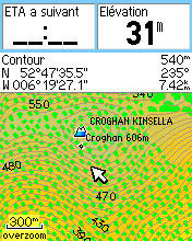
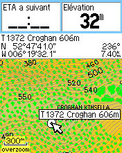
Hello Steve, Lower case letters are used by Etrex Vista HCx when you focuse an object with the cursor and Mapsource renders map with lower case letters when they are defined. I also confirm Etrex Vista HCx is able to display names in lower case letters on some POI types. Upper case letters seem to be vectorial letters for polylines. Does the option work with latin1 and codepage 1252 ? See lower case letters in action on the attached screen captures. On the capture "POI-lowercase-name", "Croghan 606m" is a pillar POI defined with the first part of name hidden (special code ~[0x1e]). You can see the full name on capture "POI-focus". Regards, David

Hi David
Lower case letters are used by Etrex Vista HCx when you focuse an object with the cursor and Mapsource renders map with lower case letters when they are defined. I also confirm Etrex Vista HCx is able to display names in lower case letters on some POI types. Upper case letters seem to be vectorial letters for polylines. Does the option work with latin1 and codepage 1252 ?
Yes it is only used when a codepage is defined (and in the latest code latin1 is equivalent to setting a codepage, but that is new, previously it would not have recognised lower-case with latin1).
See lower case letters in action on the attached screen captures.
There are situations where uppercase letters in the map are displayed in lowercase by mapsource and perhaps the GPS. But on my Legend Cx at least if there are lower case letters in the map, then they are displayed as tiny little squiggles. You have a later GPS, so it may be different. ..Steve

On Mon, May 11, 2009 at 10:39:12PM +0100, Steve Ratcliffe wrote:
There are situations where uppercase letters in the map are displayed in lowercase by mapsource and perhaps the GPS. But on my Legend Cx at least if there are lower case letters in the map, then they are displayed as tiny little squiggles.
I suspect that the Garmin Edge 705 displays names with "initial caps" in the tool tips. For instance, if a road is named "Kehä III" (the 3rd ring road around Helsinki), the tool tip next to the pointer arrow will say "Kehä Iii (E)" (E apparently meaning the eastbound lane). By the way, the proper Unicode char would be Ⅲ (U+2162 Roman numeral three). Are there any plans to implement translitteration for non-ASCII output? For instance, the mathematical symbols in the U+2100 do not exist in the 8-bit code pages that I am familiar with. I'd be happy to supply patches if the infrastructure is there. Marko
participants (3)
-
 David
David -
 Marko Mäkelä
 -
 Steve Ratcliffe