Problem routing over very short roads

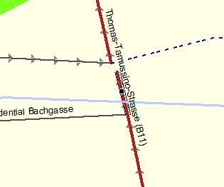
1. See here: http://www.openstreetmap.org/edit?lat=48.084294&lon=16.296498&zoom=18 Have a look at the street running paralell to the railwaylines (name Thomas-Tamussino-Straße, ref B11). Mappers have nicely and correctly entered the bridge. The section after the bridge is only about 3m long, because after the next intersection the street name changes. On compiling, these 3m get dropped and are missing. What's even worse, because the section is so short, Any autorouting wanting to go over that place, crashes in Mapsource (at least it does not crash Mapsource however, only route calculation stops with error). Here is a small screenshot of how it looks like on 20m zoom in Mapsource: I'm more than sure that there are several other places were we face the same problem, which at first look seem like mappers made mistake and did not connect road, but in reality it's one of those road segments shorter than 3.4m getting dropped.

(resent with smaller image, first message blocked by mailing list server) Hi Felix,
1. See here: http://www.openstreetmap.org/edit?lat=48.084294&lon=16.296498&zoom=18
Have a look at the street running paralell to the railwaylines (name Thomas-Tamussino-Straße, ref B11). Mappers have nicely and correctly entered the bridge. The section after the bridge is only about 3m long, because after the next intersection the street name changes.
On compiling, these 3m get dropped and are missing. What's even worse, because the section is so short, Any autorouting wanting to go over that place, crashes in Mapsource (at least it does not crash Mapsource however, only route calculation stops with error). Here is a small screenshot of how it looks like on 20m zoom in Mapsource:
I'm more than sure that there are several other places were we face the same problem, which at first look seem like mappers made mistake and did not connect road, but in reality it's one of those road segments shorter than 3.4m getting dropped.
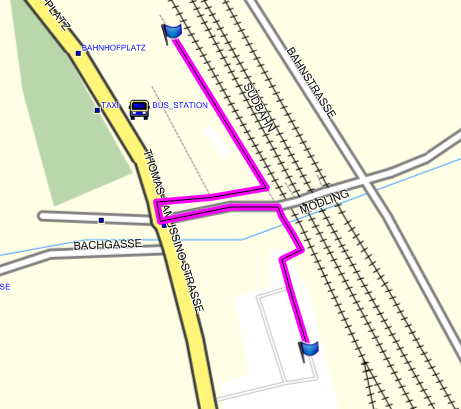
Err, I don't know what your problem is but this is what I get when I download that region and display in mapsource. Routing appears to work fine. Cheers, Mark
Err- I corrected it. Have a look at the street, not the path (which I just added - also to in case circumvent the critical road). Felix Did you see my image where the street was broken? Mark Burton wrote:
(resent with smaller image, first message blocked by mailing list server)
Hi Felix,
1. See here: http://www.openstreetmap.org/edit?lat=48.084294&lon=16.296498&zoom=18
Have a look at the street running paralell to the railwaylines (name Thomas-Tamussino-Straße, ref B11). Mappers have nicely and correctly entered the bridge. The section after the bridge is only about 3m long, because after the next intersection the street name changes.
On compiling, these 3m get dropped and are missing. What's even worse, because the section is so short, Any autorouting wanting to go over that place, crashes in Mapsource (at least it does not crash Mapsource however, only route calculation stops with error). Here is a small screenshot of how it looks like on 20m zoom in Mapsource:
I'm more than sure that there are several other places were we face the same problem, which at first look seem like mappers made mistake and did not connect road, but in reality it's one of those road segments shorter than 3.4m getting dropped.
Err, I don't know what your problem is but this is what I get when I download that region and display in mapsource. Routing appears to work fine.
Cheers,
Mark
------------------------------------------------------------------------
------------------------------------------------------------------------
_______________________________________________ mkgmap-dev mailing list mkgmap-dev@lists.mkgmap.org.uk http://www.mkgmap.org.uk/mailman/listinfo/mkgmap-dev
Just discovered a weirdness in that map. The short segment at the northern end of the bridge is actually two ways (one on top of the other). Using the middle mouse button in josm you can see that. Perhaps, this is the cause of your problems. Cheers, Mark
okay, that might be the problem. In potlatch I could not discover this. I did touch the node however already, deleting and and re-adding it to make sure it's connected, maybe It's now longer than 3.4m. It was just around 3m before. I have just uploaded my source data, try your calculation on it, I think it will fail too for you as well. http://openmtbmap.x-nation.de/maps/Debug/63660008.osm.gz Mark Burton wrote:
Just discovered a weirdness in that map.
The short segment at the northern end of the bridge is actually two ways (one on top of the other). Using the middle mouse button in josm you can see that. Perhaps, this is the cause of your problems.
Cheers,
Mark _______________________________________________ mkgmap-dev mailing list mkgmap-dev@lists.mkgmap.org.uk http://www.mkgmap.org.uk/mailman/listinfo/mkgmap-dev
Hi Felix,
I have just uploaded my source data, try your calculation on it, I think it will fail too for you as well.
That's more like it. With that map, the little segment at the N of the bridge weirds out. If you check the diagnostic output, you will see that mkgmap is not deleting that way so the end points have not resolved to the same coordinates (to make it zero length) but maybe mapsource doesn't like ways that short and is barfing on it. Cheers, Mark
Do you see any solution to this problem? I think if a way is shorter than 3.4m we get the problem. I don't think it is because of the duplicate ways. Could we maybe have a filter that joins such tiny roads to the ones it is connected too? Felix Mark Burton wrote:
Hi Felix,
I have just uploaded my source data, try your calculation on it, I think it will fail too for you as well.
That's more like it. With that map, the little segment at the N of the bridge weirds out. If you check the diagnostic output, you will see that mkgmap is not deleting that way so the end points have not resolved to the same coordinates (to make it zero length) but maybe mapsource doesn't like ways that short and is barfing on it.
Cheers,
Mark _______________________________________________ mkgmap-dev mailing list mkgmap-dev@lists.mkgmap.org.uk http://www.mkgmap.org.uk/mailman/listinfo/mkgmap-dev
Hi Felix,
Do you see any solution to this problem?
Sorry, I don't have a plan at this time.
I think if a way is shorter than 3.4m we get the problem. I don't think it is because of the duplicate ways.
It's more subtle than that because I could make a small map (just a few 100ms height and width) that included that way and mapsource was quite happy with it but when I processed your big file, it didn't like it - so either the problem is related to the density of stuff around or the size of the area being processed or something...
Could we maybe have a filter that joins such tiny roads to the ones it is connected too?
Well, if it becomes zero length that will happen anyway because that's what the new remove-short-arcs option does. What I could do is extend that code to allow the min distance to be specified so you could say --remove-short-arcs=3.5 and it would zap all arcs under than length but without the distance, i.e. just --remove-short-arcs would only zap zero length arcs. I will produce a patch to do that, should be quick to do. Cheers, Mark
Mark Burton wrote:
Hi Felix,
Do you see any solution to this problem?
Sorry, I don't have a plan at this time.
I think if a way is shorter than 3.4m we get the problem. I don't think it is because of the duplicate ways.
It's more subtle than that because I could make a small map (just a few 100ms height and width) that included that way and mapsource was quite happy with it but when I processed your big file, it didn't like it - so either the problem is related to the density of stuff around or the size of the area being processed or something...
Could we maybe have a filter that joins such tiny roads to the ones it is connected too?
Well, if it becomes zero length that will happen anyway because that's what the new remove-short-arcs option does. What I could do is extend that code to allow the min distance to be specified so you could say --remove-short-arcs=3.5 and it would zap all arcs under than length but without the distance, i.e. just --remove-short-arcs would only zap zero length arcs. I will produce a patch to do that, should be quick to do.
Would that connect all notes that are closer than 3.5m together, or only nodes that are connected to each other? My thinking is that if in case a road crosses another on a bridge, and now on the top road a node lies within 3.5m of the distance of the road below the brige, and then they are joined, this patch would only be good for experimenting, but not for really usable maps. If it only deletes nodes that are connected anyhow than I think maps will be quite usable. I suspect the same error to be actually taking place quite often (about say every 10. route calculation of aerial distance 30-40km ). Though I would have to closely watch autorouting routes more often. Felix
Cheers,
Mark _______________________________________________ mkgmap-dev mailing list mkgmap-dev@lists.mkgmap.org.uk http://www.mkgmap.org.uk/mailman/listinfo/mkgmap-dev

okay, that might be the problem. In potlatch I could not discover this.
It's a common mistake. I had some problems myself with these multiple copies of ways. This could help: http://wiki.openstreetmap.org/wiki/Stammtisch_Hannover_Tipps#Doppelte_Wege_f... (German) http://wiki.openstreetmap.org/wiki/Potlatch/Keyboard_shortcuts (English, look for '/' key description) Markus
I did touch the node however already, deleting and and re-adding it to make sure it's connected, maybe It's now longer than 3.4m. It was just around 3m before. I have just uploaded my source data, try your calculation on it, I think it will fail too for you as well.
http://openmtbmap.x-nation.de/maps/Debug/63660008.osm.gz
Mark Burton wrote:
Just discovered a weirdness in that map.
The short segment at the northern end of the bridge is actually two ways (one on top of the other). Using the middle mouse button in josm you can see that. Perhaps, this is the cause of your problems.
Cheers,
Mark _______________________________________________ mkgmap-dev mailing list mkgmap-dev@lists.mkgmap.org.uk http://www.mkgmap.org.uk/mailman/listinfo/mkgmap-dev
_______________________________________________ mkgmap-dev mailing list mkgmap-dev@lists.mkgmap.org.uk http://www.mkgmap.org.uk/mailman/listinfo/mkgmap-dev
participants (3)
-
 Felix Hartmann
 -
 gypakk@gmx.eu
 -
 Mark Burton