
How are street/highway/POI labels controlled, level and font size? How can I change them?

About levels, you can specify resolution or level in your style files For example tourism=hotel [0x2b01 resolution 24] 24 means that a hotel appears only in the highest zoom level If you specify 20 it appears from zoom 20 or higher. If you specify 20-22 it appears only in that range, so not on the highest zoom level 24 https://wiki.openstreetmap.org/wiki/Mkgmap/help/custom Font size can only be specified in the typ file, I use an editor like typviewer. You can choose an invisible, small, default or large font style. But bear in mind that on most Garmins units font size can be controlled only if it is set to default in the typ file. Brad wrote: How are street/highway/POI labels controlled, level and font size? How can I change them?


Hi, I think it depends on the selected map detail level what labels are rendered. Gerd ________________________________________ Von: mkgmap-dev <mkgmap-dev-bounces@lists.mkgmap.org.uk> im Auftrag von Arndt Röhrig <arndt@speichenkarte.de> Gesendet: Samstag, 1. Dezember 2018 11:34 An: Development list for mkgmap; lig fietser; brad Betreff: Re: [mkgmap-dev] label rendering Hi all, My observation is, that ome POIs are hard-wired in BaseCamp. They care little about "resolution." On an Oregon and certainly other Garmins, there is an option to zoom scales. If you place there 200m all POIs uses this value. Greetz Arndt lig fietser <ligfietser@hotmail.com> hat am 1. Dezember 2018 um 09:28 geschrieben: About levels, you can specify resolution or level in your style files For example tourism=hotel [0x2b01 resolution 24] 24 means that a hotel appears only in the highest zoom level If you specify 20 it appears from zoom 20 or higher. If you specify 20-22 it appears only in that range, so not on the highest zoom level 24 https://wiki.openstreetmap.org/wiki/Mkgmap/help/custom Font size can only be specified in the typ file, I use an editor like typviewer. You can choose an invisible, small, default or large font style. But bear in mind that on most Garmins units font size can be controlled only if it is set to default in the typ file. Brad wrote: How are street/highway/POI labels controlled, level and font size? How can I change them? _______________________________________________ mkgmap-dev mailing list mkgmap-dev@lists.mkgmap.org.uk http://www.mkgmap.org.uk/mailman/listinfo/mkgmap-dev
Yes, what Arndt writes is correct, for most pois Basecamp decides when it shows up. But there are some pois that Basecamp does not control, so you can use mkgmap to set those levels. I don't have a list of which pois are controlled by Basecamp, it is always a matter of trial and error. Complicated factor is that it also depends on the device; it is totally non consistent, sometimes a big mess what Garmin has made. And the rendering in Mapsource is also different, but it is more compatible with mkgmap than Basecamp. ________________________________ Van: mkgmap-dev <mkgmap-dev-bounces@lists.mkgmap.org.uk> namens Arndt Röhrig <arndt@speichenkarte.de> Verzonden: zaterdag 1 december 2018 03:41 Aan: Development list for mkgmap Onderwerp: Re: [mkgmap-dev] label rendering With hardwired I mean next: For exampel: amenity=fuel [0x2f01 resolution 22] and detail level "middle". The gas stations disapper at 70m. But the switch between resolution 24 and 23 is at 300m and between 23 and 22 at 500m. Sure, a higher detail level and the station will disappear later, but not at the scale like other elements.
thx, I got it figured out for towns/villages to show at a lower resolution. Road labels still have me puzzled. I know how to control the level/resolution for the road, but how can I get labels at a lower resolution, or more labels? I don't use Basecamp, I use QMapshack and a Garmin Montana. On 12/1/18 5:28 AM, lig fietser wrote:
Yes, what Arndt writes is correct, for most pois Basecamp decides when it shows up. But there are some pois that Basecamp does not control, so you can use mkgmap to set those levels. I don't have a list of which pois are controlled by Basecamp, it is always a matter of trial and error. Complicated factor is that it also depends on the device; it is totally non consistent, sometimes a big mess what Garmin has made. And the rendering in Mapsource is also different, but it is more compatible with mkgmap than Basecamp.
------------------------------------------------------------------------ *Van:* mkgmap-dev <mkgmap-dev-bounces@lists.mkgmap.org.uk> namens Arndt Röhrig <arndt@speichenkarte.de> *Verzonden:* zaterdag 1 december 2018 03:41 *Aan:* Development list for mkgmap *Onderwerp:* Re: [mkgmap-dev] label rendering With hardwired I mean next:
For exampel:
amenity=fuel [0x2f01 resolution 22] and detail level "middle".
The gas stations disapper at 70m. But the switch between resolution 24 and 23 is at 300m and between 23 and 22 at 500m.
Sure, a higher detail level and the station will disappear later, but not at the scale like other elements.
_______________________________________________ mkgmap-dev mailing list mkgmap-dev@lists.mkgmap.org.uk http://www.mkgmap.org.uk/mailman/listinfo/mkgmap-dev
The road labels only show up with the most detailed level or resolution. On 12/1/18 1:43 PM, brad wrote:
thx, I got it figured out for towns/villages to show at a lower resolution. Road labels still have me puzzled. I know how to control the level/resolution for the road, but how can I get labels at a lower resolution, or more labels? I don't use Basecamp, I use QMapshack and a Garmin Montana.
On 12/1/18 5:28 AM, lig fietser wrote:
Yes, what Arndt writes is correct, for most pois Basecamp decides when it shows up. But there are some pois that Basecamp does not control, so you can use mkgmap to set those levels. I don't have a list of which pois are controlled by Basecamp, it is always a matter of trial and error. Complicated factor is that it also depends on the device; it is totally non consistent, sometimes a big mess what Garmin has made. And the rendering in Mapsource is also different, but it is more compatible with mkgmap than Basecamp.
------------------------------------------------------------------------ *Van:* mkgmap-dev <mkgmap-dev-bounces@lists.mkgmap.org.uk> namens Arndt Röhrig <arndt@speichenkarte.de> *Verzonden:* zaterdag 1 december 2018 03:41 *Aan:* Development list for mkgmap *Onderwerp:* Re: [mkgmap-dev] label rendering With hardwired I mean next:
For exampel:
amenity=fuel [0x2f01 resolution 22] and detail level "middle".
The gas stations disapper at 70m. But the switch between resolution 24 and 23 is at 300m and between 23 and 22 at 500m.
Sure, a higher detail level and the station will disappear later, but not at the scale like other elements.
_______________________________________________ mkgmap-dev mailing list mkgmap-dev@lists.mkgmap.org.uk http://www.mkgmap.org.uk/mailman/listinfo/mkgmap-dev
_______________________________________________ mkgmap-dev mailing list mkgmap-dev@lists.mkgmap.org.uk http://www.mkgmap.org.uk/mailman/listinfo/mkgmap-dev

On my Etrex: Map Setup > Advanced Map Setup > Zoom Levels > Auto zoom: on/off Zoom Levels > 4 controls for the resolutions at which following appear Points/Waypoints/Street labels/Land Cover Text Size (Points, Streets, Etc) > 4 controls for Points/Waypoints/Street labels/Land cover Detail > 5 levels of detail I haven't experimented with the effect of all of these - mostly leaving them with the default setting. Does your Montana have similar? Ticker
On my Montana, those settings don't seem to do anything. I am getting better labels than with qmapshack, some primary hwy labels with level 2-6, not much change from 2-6, some additional labels at level 1/res23. I wonder if part of the problem may be that the names are very long, I'll try substituting the 'ref' tag instead 'name' & see if that helps. I've mostly been using QMapShack for my debugging. It's actually worse than the Garmin Montana. I have some primary highway labels showing up at level0/res 24, along with other road labels. It's inconsistent though, 1 of the primary highways labels doesn't show up with any resolution. I get the same results with my downloaded Openfietsmap Lite maps. Is this something that we can't control? On 12/2/18 4:07 AM, Ticker Berkin wrote:
On my Etrex:
Map Setup > Advanced Map Setup > Zoom Levels > Auto zoom: on/off Zoom Levels > 4 controls for the resolutions at which following appear Points/Waypoints/Street labels/Land Cover Text Size (Points, Streets, Etc) > 4 controls for Points/Waypoints/Street labels/Land cover Detail > 5 levels of detail
I haven't experimented with the effect of all of these - mostly leaving them with the default setting. Does your Montana have similar?
Ticker
_______________________________________________ mkgmap-dev mailing list mkgmap-dev@lists.mkgmap.org.uk http://www.mkgmap.org.uk/mailman/listinfo/mkgmap-dev

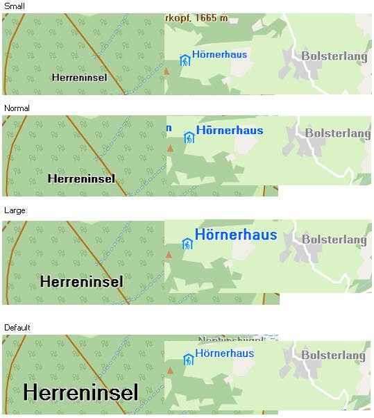
Hi Brad Maybe somebody already addressed it, but in Basecamp and my Oregon label size also depends on whether poi's do or do not have an icon. Especially when specified as ’default-size’ a lable without icon is huge where the lable with icon and ‘default-size’ will be relatively small [cid:image003.jpg@01D48C74.BF2CB460] -----Oorspronkelijk bericht----- Van: mkgmap-dev <mkgmap-dev-bounces@lists.mkgmap.org.uk> Namens brad Verzonden: maandag 3 december 2018 04:45 Aan: mkgmap-dev@lists.mkgmap.org.uk Onderwerp: Re: [mkgmap-dev] label rendering On my Montana, those settings don't seem to do anything. I am getting better labels than with qmapshack, some primary hwy labels with level 2-6, not much change from 2-6, some additional labels at level 1/res23. I wonder if part of the problem may be that the names are very long, I'll try substituting the 'ref' tag instead 'name' & see if that helps. I've mostly been using QMapShack for my debugging. It's actually worse than the Garmin Montana. I have some primary highway labels showing up at level0/res 24, along with other road labels. It's inconsistent though, 1 of the primary highways labels doesn't show up with any resolution. I get the same results with my downloaded Openfietsmap Lite maps. Is this something that we can't control? On 12/2/18 4:07 AM, Ticker Berkin wrote:
On my Etrex:
Map Setup > Advanced Map Setup >
Zoom Levels >
Auto zoom: on/off
Zoom Levels >
4 controls for the resolutions at which following appear
Points/Waypoints/Street labels/Land Cover
Text Size (Points, Streets, Etc) >
4 controls for Points/Waypoints/Street labels/Land cover
Detail > 5 levels of detail
I haven't experimented with the effect of all of these - mostly
leaving them with the default setting. Does your Montana have similar?
Ticker
_______________________________________________
mkgmap-dev mailing list
mkgmap-dev@lists.mkgmap.org.uk<mailto:mkgmap-dev@lists.mkgmap.org.uk>
_______________________________________________ mkgmap-dev mailing list mkgmap-dev@lists.mkgmap.org.uk<mailto:mkgmap-dev@lists.mkgmap.org.uk> http://www.mkgmap.org.uk/mailman/listinfo/mkgmap-dev

Hi Brad, there are many factors: - Style for mkgmap, used for compiling. It defines maximum level of an object and the content of a label. Some markers in label can hide a part of a label, depending on zoom level. - TYP file attached to mapset. It defines graphics of an object, size and colour of a label and label visibility. - Settings in GPS. Some GPS allow to modify maximum zoom levels, label sizes and visibility. - Hardcoded properties of GPS. Some GPS don't allow for settings and these properties are simply hardcoded. Many POI have a hardcoded maximum level, railroads 0x14 usually are limited to most detailed level. -- Best regards, Andrzej
participants (7)
-
 Andrzej Popowski
 -
 Arndt Röhrig
 -
 brad
brad -
 Gerd Petermann
 -
 Joris Bo
 -
 lig fietser
 -
 Ticker Berkin