
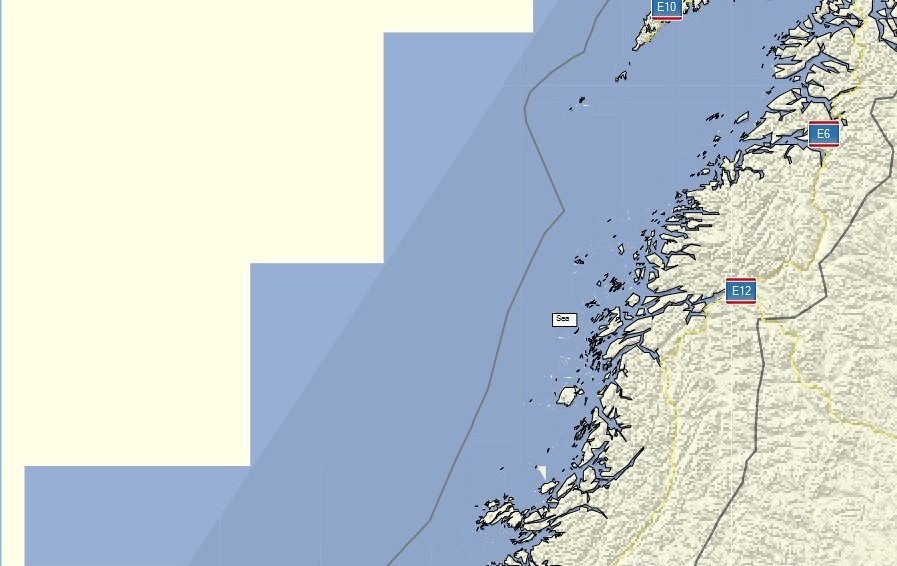
Hi all, I think that the bounding polygon given with option --dem-poly should be also be used in the precomp-sea option, so that mkgmap doesn't generate sea polygons outside of the bounding polygon. With the current code a map of e.g. scandinavia looks strange, see attached picture. In a further step I should try to use that polygon also for the background polygon (0x4B) and other data. In a final step we might be able to use it for routing data so that you can split maps at left-driving / right-driving boundaries, but that needs more thinking. I've not coded anything yet, but I wonder if the option should be changed from dem-poly to e.g. --polygon-file or --bounding-polygon. Gerd

El 10/01/18 a las 09:54, Gerd Petermann escribió:
Hi all,
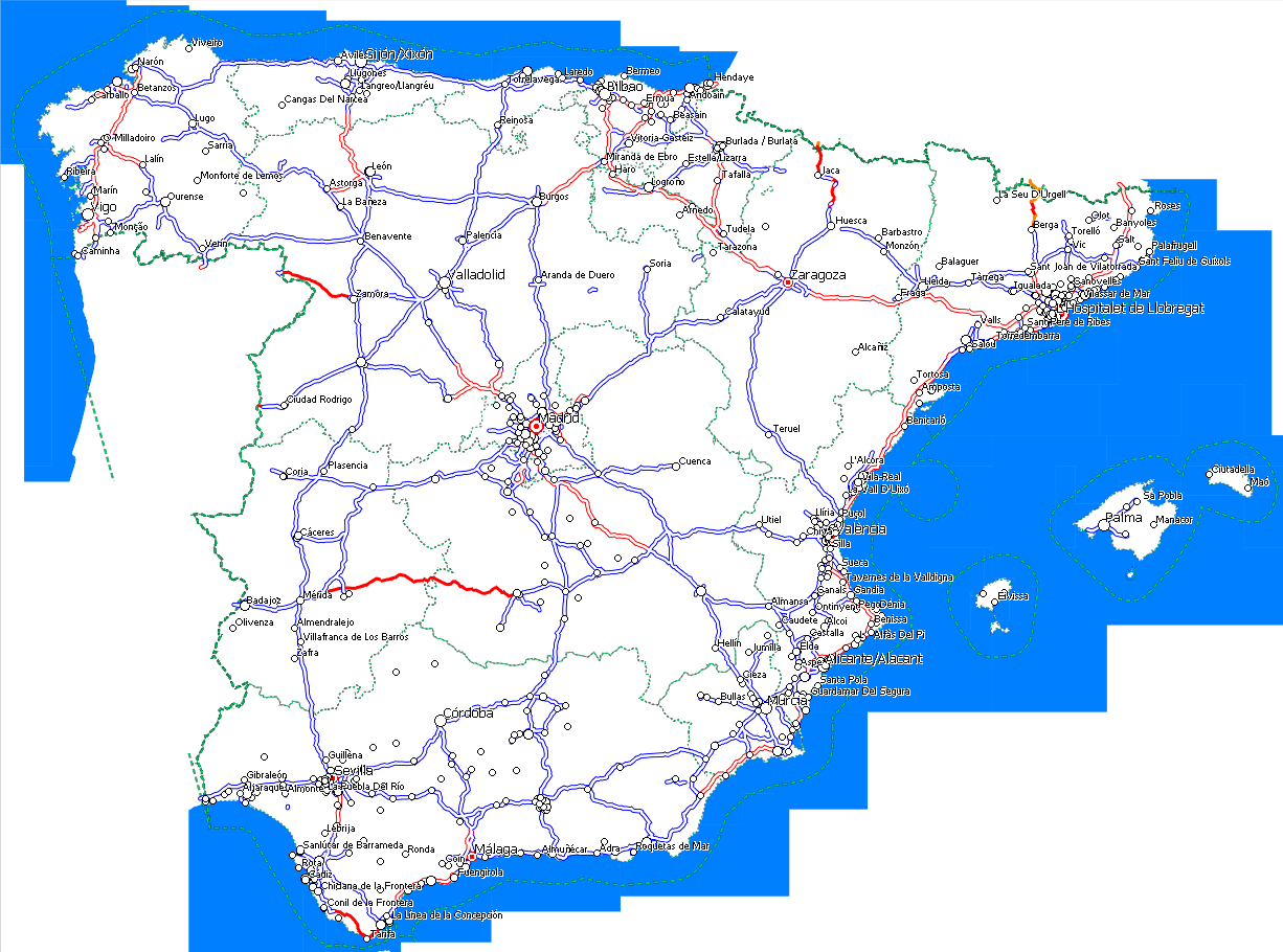
I think that the bounding polygon given with option --dem-poly should be also be used in the precomp-sea option, so that mkgmap doesn't generate sea polygons outside of the bounding polygon. With the current code a map of e.g. scandinavia looks strange, see attached picture. I think that could also lead to stranger results, see attached screenshots, one from JOSM showing my spain.poly and other one from MapSource showing resulting map. I would prefer to show sea as currently rather than cut by spain.poly. Anyway, that could be an option, the same than currently we have --no-trim in splitter to get right the opposite effect.
In a further step I should try to use that polygon also for the background polygon (0x4B) and other data. In a final step we might be able to use it for routing data so that you can split maps at left-driving / right-driving boundaries, but that needs more thinking. Splitting maps at left/right driving boundaries or country boundaries would really be a great improvement.
I've not coded anything yet, but I wonder if the option should be changed from dem-poly to e.g. --polygon-file or --bounding-polygon.
Gerd

Hi Gerd, I like the idea to have somehow a map polygone limiting or extending the 'background'-map (means DEM, sea, background poly). How about --map-polygon? So if I got it right, this develloping will end in non-rectangle shaped map tiles? Henning On 10.01.2018 16:54, Gerd Petermann wrote:
Hi all,
I think that the bounding polygon given with option --dem-poly should be also be used in the precomp-sea option, so that mkgmap doesn't generate sea polygons outside of the bounding polygon. With the current code a map of e.g. scandinavia looks strange, see attached picture.
In a further step I should try to use that polygon also for the background polygon (0x4B) and other data. In a final step we might be able to use it for routing data so that you can split maps at left-driving / right-driving boundaries, but that needs more thinking.
I've not coded anything yet, but I wonder if the option should be changed from dem-poly to e.g. --polygon-file or --bounding-polygon.
Gerd
_______________________________________________ mkgmap-dev mailing list mkgmap-dev@lists.mkgmap.org.uk http://www.mkgmap.org.uk/mailman/listinfo/mkgmap-dev

Hi Gerd, DEM shading is displayed only over background object 4B. If you clip background, than the effect is like clipping DEM too. -- Best regards, Andrzej
Hi Andrzej, yes, and maybe that's also an explanation for the problems with the hill shading. The current implementation in mkgmap fills the values outside of the polygon with "invalid" height. Maybe Garmin only does that for those sub tiles which are completely outside of the polygon. I can verify that because I don't have a map with DEM data and non-rectangular background shape. Gerd ________________________________________ Von: mkgmap-dev <mkgmap-dev-bounces@lists.mkgmap.org.uk> im Auftrag von Andrzej Popowski <popej@poczta.onet.pl> Gesendet: Donnerstag, 11. Januar 2018 17:01:01 An: mkgmap-dev@lists.mkgmap.org.uk Betreff: Re: [mkgmap-dev] dem-poly and precomp-sea Hi Gerd, DEM shading is displayed only over background object 4B. If you clip background, than the effect is like clipping DEM too. -- Best regards, Andrzej _______________________________________________ mkgmap-dev mailing list mkgmap-dev@lists.mkgmap.org.uk http://www.mkgmap.org.uk/mailman/listinfo/mkgmap-dev
Hi Gerd, probably all Garmin's map have irregular background. You can look for example at old Winter Activity Map: https://static.garmincdn.com/shared/de/custom/winter2013/_download/winterkar... It is GMP, but DEM data should be the same. -- Best regards, Andrzej
participants (5)
-
 Andrzej Popowski
 -
 Carlos Dávila
 -
 Gerd Petermann
 -
Gerd Petermann
-
 Henning Scholland