dent in street and bounds problem

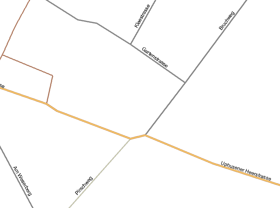
Moin, I have attached an OSM-file, where i have to effects with mkgmap-1562: 1. If I convert the OSM-file without any prior editing, the resulting map in mapsource is empty. If I remove the bounds section first, then I get the expected result. I don't know, wether the bounds are set incorrectly by JOSM (I created the OSM file by downloading and saving the data with JOSM), or whether mkgmap has a problem with such small bounds sections. 2. In the attached screen shot you can see the resulting map created by the attached OSM-file. If you zoom in very closely, there is a dent in the secondary road. If I open the OSM-file in JOSM, there is no such dent visible. Is this a data resolution problem of the Garmin format? In JOSM the intersection with the Pirschweg is more north than the intersection with the Bruchweg, in Mapsource it is inverse. Gruss Torsten

Hello Torsten,
2. In the attached screen shot you can see the resulting map created by the attached OSM-file. If you zoom in very closely, there is a dent in the secondary road. If I open the OSM-file in JOSM, there is no such dent visible. Is this a data resolution problem of the Garmin format?
Yes, as the Garmin map resolution is approx 2.2m, it is understandable for your road to have those dents. Cheers, Mark
Mark Burton schrieb am 14.02.2010 20:05:
Yes, as the Garmin map resolution is approx 2.2m, it is understandable for your road to have those dents.
But the offset of the points look much bigger than 2.2m. And this doesn't explain, why the north-south ordering of the two points is in JOSM inverse to the ordering in Mapsource or on my Nuevi. Gruss Torsten

On 14.02.2010 20:53, Torsten Leistikow wrote:
Mark Burton schrieb am 14.02.2010 20:05:
Yes, as the Garmin map resolution is approx 2.2m, it is understandable for your road to have those dents.
But the offset of the points look much bigger than 2.2m. And this doesn't explain, why the north-south ordering of the two points is in JOSM inverse to the ordering in Mapsource or on my Nuevi.
That is a bug in Mapsource and won't get solved. Use Mapsource 6.13.6 (for x64 systems) or Mapsource 6.13.7 for x32 system.
Gruss Torsten _______________________________________________ mkgmap-dev mailing list mkgmap-dev@lists.mkgmap.org.uk http://www.mkgmap.org.uk/mailman/listinfo/mkgmap-dev
Felix Hartmann schrieb am 14.02.2010 21:10:
That is a bug in Mapsource and won't get solved. Use Mapsource 6.13.6 (for x64 systems) or Mapsource 6.13.7 for x32 system.
This might help, I am using a 6.11 version of Mapsource. Unfortunately my Nuevi displays it in the same way Gruss Torsten
Hello Torsten,
Mark Burton schrieb am 14.02.2010 20:05:
Yes, as the Garmin map resolution is approx 2.2m, it is understandable for your road to have those dents.
But the offset of the points look much bigger than 2.2m. And this doesn't explain, why the north-south ordering of the two points is in JOSM inverse to the ordering in Mapsource or on my Nuevi.
How about: the RHS of the dent is S of the junction with Bruchweg because the small footway has been completely removed by the remove-short-arcs option and so the node at the N end of that footway has been merged into the node at the S end of the footway which is why the way ends up kinked to the S. Mark
Mark Burton schrieb am 14.02.2010 23:15:
How about: the RHS of the dent is S of the junction with Bruchweg because the small footway has been completely removed by the remove-short-arcs option and so the node at the N end of that footway has been merged into the node at the S end of the footway which is why the way ends up kinked to the S.
I haven't noticed this, but your right: The footway is misisng in the garmin map. But is this not a much bigger problem? Now in the Garmin map two roads are connected, which are not connected in the OSM data. I think the remove-short-arcs option mustn't remove complete elements, because the routing is now broken. And such a case is not so exceptional: Here it is quite common, that an end of a road is closed for vehicle traffic or declared as oneway for reducing the traffic in residential areas. Gruss Torsten
Hello Torsten,
Mark Burton schrieb am 14.02.2010 23:15:
How about: the RHS of the dent is S of the junction with Bruchweg because the small footway has been completely removed by the remove-short-arcs option and so the node at the N end of that footway has been merged into the node at the S end of the footway which is why the way ends up kinked to the S.
I haven't noticed this, but your right: The footway is misisng in the garmin map.
But is this not a much bigger problem? Now in the Garmin map two roads are connected, which are not connected in the OSM data. I think the remove-short-arcs option mustn't remove complete elements, because the routing is now broken. And such a case is not so exceptional: Here it is quite common, that an end of a road is closed for vehicle traffic or declared as oneway for reducing the traffic in residential areas.
Yes, that's not ideal is it. I will add it to the list of bugs that I need to fix. Cheers, Mark
participants (3)
-
 Felix Hartmann
 -
 Mark Burton
 -
 Torsten Leistikow