Some bounderies shown as river

Hi, I have in my card no boundaries selected. Since mkgmap-r1707 some boundaries are shown as riverin QLandkarte GT. I have created some tracks which show this behaviour. Mkgmap-r1625 is o.k. You can download the tracks from here: http://www.dateihosting.de/file/details/172603/Pseudofluesse.gpx Greetings Josef
Hi, one of the river (tracks Rhein) where the boundaries, shown as river, starts has two ways. One with tag boundary and waterway=river, the other only with waterway=river. The other one (tracks Mosel) has one way with tag boundary and waterway=river. In the first case I removed the tag waterway=river from the way with tag boundary. This resolves the problem for this river. Therefore you can see the false behaviour only at the tracks Mosel. Greetings Josef Am 04.10.2010 17:55, schrieb Josef Latt:
Hi,
I have in my card no boundaries selected. Since mkgmap-r1707 some boundaries are shown as riverin QLandkarte GT. I have created some tracks which show this behaviour. Mkgmap-r1625 is o.k.
You can download the tracks from here:
http://www.dateihosting.de/file/details/172603/Pseudofluesse.gpx
Greetings Josef _______________________________________________ mkgmap-dev mailing list mkgmap-dev@lists.mkgmap.org.uk http://www.mkgmap.org.uk/mailman/listinfo/mkgmap-dev
Screenshot attached. Am 07.10.2010 11:23, schrieb Josef Latt:
Hi,
one of the river (tracks Rhein) where the boundaries, shown as river, starts has two ways. One with tag boundary and waterway=river, the other only with waterway=river. The other one (tracks Mosel) has one way with tag boundary and waterway=river.
In the first case I removed the tag waterway=river from the way with tag boundary. This resolves the problem for this river. Therefore you can see the false behaviour only at the tracks Mosel.
Greetings Josef
Am 04.10.2010 17:55, schrieb Josef Latt:
Hi,
I have in my card no boundaries selected. Since mkgmap-r1707 some boundaries are shown as riverin QLandkarte GT. I have created some tracks which show this behaviour. Mkgmap-r1625 is o.k.
You can download the tracks from here:
http://www.dateihosting.de/file/details/172603/Pseudofluesse.gpx
Greetings Josef _______________________________________________ mkgmap-dev mailing list mkgmap-dev@lists.mkgmap.org.uk http://www.mkgmap.org.uk/mailman/listinfo/mkgmap-dev
_______________________________________________ mkgmap-dev mailing list mkgmap-dev@lists.mkgmap.org.uk http://www.mkgmap.org.uk/mailman/listinfo/mkgmap-dev

Josef Latt schrieb am 07.10.2010 11:23:
one of the river (tracks Rhein) where the boundaries, shown as river, starts has two ways. One with tag boundary and waterway=river, the other only with waterway=river.
I don't understand your problem. When the way ist tagged as boundary and as river at the same time, you shouldn't be surprised, when this is displayed as a river. So right now this sounds to me like a mapping error and not like a mkgmap problem. Gruss Torsten
Am 07.10.2010 18:08, schrieb Torsten Leistikow:
Josef Latt schrieb am 07.10.2010 11:23:
one of the river (tracks Rhein) where the boundaries, shown as river, starts has two ways. One with tag boundary and waterway=river, the other only with waterway=river.
I don't understand your problem. When the way ist tagged as boundary and as river at the same time, you shouldn't be surprised, when this is displayed as a river. So right now this sounds to me like a mapping error and not like a mkgmap problem.
That means that a tagging like this is false? <?xml version="1.0"?> <osm generator="Merkaartor 0.16" version="0.6"> <node version="1" lon="7.43785560" lat="50.22632410" timestamp="2010-04-07T20:32:23Z" user="bundesrainer" id="687862342" actor="2"/> <way version="2" timestamp="2010-06-22T11:26:11Z" user="Geogast" id="54643300" actor="2"> <nd ref="687862342"/> <nd ref="298275173"/> <nd ref="301913638"/> <tag k="admin_level" v="8"/> <tag k="boundary" v="administrative"/> <tag k="history" v="Retrieved from v8"/> <tag k="name" v="Mosel"/> <tag k="name:de" v="Mosel"/> <tag k="name:es" v="Mosela"/> <tag k="name:fr" v="Moselle"/> <tag k="note" v="MapFeatures suggest to have waterway=river in additon to waterway=riverbank, this is why its here"/> <tag k="waterway" v="river"/> </way> <node version="16" lon="7.44285940" lat="50.22731440" timestamp="2009-03-05T17:08:14Z" user="KK-O" id="298275173" actor="2"/> <node version="14" lon="7.44647270" lat="50.22997290" timestamp="2009-03-05T17:08:14Z" user="KK-O" id="301913638" actor="2"/> <bound box="50.226324,7.437856,50.229973,7.446473" origin="http://www.openstreetmap.org/api/0.6"/> </osm> But, why mkgmap-r1625 doesn't have this bug and why show other similar tags down the Mosel no boundaries as river? Greetings Josef
Josef Latt schrieb am 07.10.2010 20:03:
That means that a tagging like this is false? ...
<tag k="boundary" v="administrative"/>
...
<tag k="waterway" v="river"/>
If the river itself is the boundary, then this tagging is ok. But in such a case, you can't complain, that the boundary is shown as a river, because the displayed element is a river as well as a boundary. So it is just a matter of display priority.
From your screenshot I can now guess, what you mean: There are also other ways in the map, which are dislpayed as river, although they are only tagged as boundary AND NOT as river at the same time?
If this is the case, I would guess, that the complete boundary is made up out of a multipolygon. In this case the multipolygon tagging seems to be faulty. Either all outer ways must be tagged the same (this can not be, since one part is tagged as a river, while other parts shouldn't be rivers), or the tag values for the multipolygon must be placed on the relation instead of the outer ways (this is also not done in the example, since the boundary tag is on the way and not on the relation). Gruss Torsten
Am 07.10.2010 21:37, schrieb Torsten Leistikow:
Josef Latt schrieb am 07.10.2010 20:03:
That means that a tagging like this is false? ...
<tag k="boundary" v="administrative"/>
...
<tag k="waterway" v="river"/>
If the river itself is the boundary, then this tagging is ok.
But in such a case, you can't complain, that the boundary is shown as a river, because the displayed element is a river as well as a boundary. So it is just a matter of display priority.
From your screenshot I can now guess, what you mean: There are also other ways in the map, which are dislpayed as river, although they are only tagged as boundary AND NOT as river at the same time?
If this is the case, I would guess, that the complete boundary is made up out of a multipolygon.
In this case the multipolygon tagging seems to be faulty. Either all outer ways must be tagged the same (this can not be, since one part is tagged as a river, while other parts shouldn't be rivers), or the tag values for the multipolygon must be placed on the relation instead of the outer ways (this is also not done in the example, since the boundary tag is on the way and not on the relation).
That is to high for me, as I'm relativ new in tagging. But I can't see any difference to other boundaries with IMHO same tagging. E.g. http://www.openstreetmap.org/?lat=50.2275&lon=7.4450&zoom=15. It's rel_546624. Greetings Josef
Other boundaries shown as river: http://www.openstreetmap.org/?lat=50.7548&lon=7.3343&zoom=12 -> Relation 'Hennef (Sieg) rel_36042' Greetings Josef Am 08.10.2010 07:37, schrieb Josef Latt:
Am 07.10.2010 21:37, schrieb Torsten Leistikow:
Josef Latt schrieb am 07.10.2010 20:03:
That means that a tagging like this is false? ...
<tag k="boundary" v="administrative"/>
...
<tag k="waterway" v="river"/>
If the river itself is the boundary, then this tagging is ok.
But in such a case, you can't complain, that the boundary is shown as a river, because the displayed element is a river as well as a boundary. So it is just a matter of display priority.
From your screenshot I can now guess, what you mean: There are also other ways in the map, which are dislpayed as river, although they are only tagged as boundary AND NOT as river at the same time?
If this is the case, I would guess, that the complete boundary is made up out of a multipolygon.
In this case the multipolygon tagging seems to be faulty. Either all outer ways must be tagged the same (this can not be, since one part is tagged as a river, while other parts shouldn't be rivers), or the tag values for the multipolygon must be placed on the relation instead of the outer ways (this is also not done in the example, since the boundary tag is on the way and not on the relation).
That is to high for me, as I'm relativ new in tagging. But I can't see any difference to other boundaries with IMHO same tagging. E.g. http://www.openstreetmap.org/?lat=50.2275&lon=7.4450&zoom=15. It's rel_546624.
Greetings Josef _______________________________________________ mkgmap-dev mailing list mkgmap-dev@lists.mkgmap.org.uk http://www.mkgmap.org.uk/mailman/listinfo/mkgmap-dev
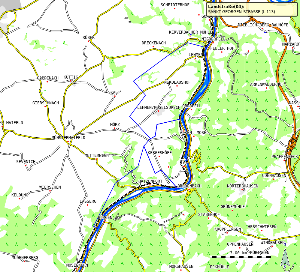
I forgot to list again the old ones: http://www.openstreetmap.org/?lat=50.2509&lon=7.4284&zoom=12 -> Gemeinde Hatzenport rel_546634 -> Gemeinde Löf rel_546642 -> Gemeinde Lehmen rel_546640 Am 08.10.2010 16:07, schrieb Josef Latt:
Other boundaries shown as river:
http://www.openstreetmap.org/?lat=50.7548&lon=7.3343&zoom=12 -> Relation 'Hennef (Sieg) rel_36042'
Greetings Josef
Am 08.10.2010 07:37, schrieb Josef Latt:
Am 07.10.2010 21:37, schrieb Torsten Leistikow:
Josef Latt schrieb am 07.10.2010 20:03:
That means that a tagging like this is false? ...
<tag k="boundary" v="administrative"/>
...
<tag k="waterway" v="river"/>
If the river itself is the boundary, then this tagging is ok.
But in such a case, you can't complain, that the boundary is shown as a river, because the displayed element is a river as well as a boundary. So it is just a matter of display priority.
From your screenshot I can now guess, what you mean: There are also other ways in the map, which are dislpayed as river, although they are only tagged as boundary AND NOT as river at the same time?
If this is the case, I would guess, that the complete boundary is made up out of a multipolygon.
In this case the multipolygon tagging seems to be faulty. Either all outer ways must be tagged the same (this can not be, since one part is tagged as a river, while other parts shouldn't be rivers), or the tag values for the multipolygon must be placed on the relation instead of the outer ways (this is also not done in the example, since the boundary tag is on the way and not on the relation).
That is to high for me, as I'm relativ new in tagging. But I can't see any difference to other boundaries with IMHO same tagging. E.g. http://www.openstreetmap.org/?lat=50.2275&lon=7.4450&zoom=15. It's rel_546624.
Greetings Josef _______________________________________________ mkgmap-dev mailing list mkgmap-dev@lists.mkgmap.org.uk http://www.mkgmap.org.uk/mailman/listinfo/mkgmap-dev
_______________________________________________ mkgmap-dev mailing list mkgmap-dev@lists.mkgmap.org.uk http://www.mkgmap.org.uk/mailman/listinfo/mkgmap-dev
The posted links work only in merkaartor, as I noticed afterwards. I use merkaartor at 99.9 %. Sorry Am 08.10.2010 16:23, schrieb Josef Latt:
I forgot to list again the old ones:
http://www.openstreetmap.org/?lat=50.2509&lon=7.4284&zoom=12 -> Gemeinde Hatzenport rel_546634 -> Gemeinde Löf rel_546642 -> Gemeinde Lehmen rel_546640
Am 08.10.2010 16:07, schrieb Josef Latt:
Other boundaries shown as river:
http://www.openstreetmap.org/?lat=50.7548&lon=7.3343&zoom=12 -> Relation 'Hennef (Sieg) rel_36042'
Greetings Josef
Am 08.10.2010 07:37, schrieb Josef Latt:
Am 07.10.2010 21:37, schrieb Torsten Leistikow:
Josef Latt schrieb am 07.10.2010 20:03:
That means that a tagging like this is false? ...
<tag k="boundary" v="administrative"/>
...
<tag k="waterway" v="river"/>
If the river itself is the boundary, then this tagging is ok.
But in such a case, you can't complain, that the boundary is shown as a river, because the displayed element is a river as well as a boundary. So it is just a matter of display priority.
From your screenshot I can now guess, what you mean: There are also other ways in the map, which are dislpayed as river, although they are only tagged as boundary AND NOT as river at the same time?
If this is the case, I would guess, that the complete boundary is made up out of a multipolygon.
In this case the multipolygon tagging seems to be faulty. Either all outer ways must be tagged the same (this can not be, since one part is tagged as a river, while other parts shouldn't be rivers), or the tag values for the multipolygon must be placed on the relation instead of the outer ways (this is also not done in the example, since the boundary tag is on the way and not on the relation).
That is to high for me, as I'm relativ new in tagging. But I can't see any difference to other boundaries with IMHO same tagging. E.g. http://www.openstreetmap.org/?lat=50.2275&lon=7.4450&zoom=15. It's rel_546624.
Greetings Josef _______________________________________________ mkgmap-dev mailing list mkgmap-dev@lists.mkgmap.org.uk http://www.mkgmap.org.uk/mailman/listinfo/mkgmap-dev
_______________________________________________ mkgmap-dev mailing list mkgmap-dev@lists.mkgmap.org.uk http://www.mkgmap.org.uk/mailman/listinfo/mkgmap-dev
_______________________________________________ mkgmap-dev mailing list mkgmap-dev@lists.mkgmap.org.uk http://www.mkgmap.org.uk/mailman/listinfo/mkgmap-dev
participants (2)
-
 Josef Latt
 -
 Torsten Leistikow