
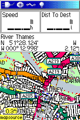
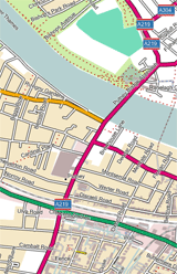
Hi all, Many people have created TYP files that define lines to have borders, to make them look more like paper maps (e.g. the UK's OS series). This looks fine in Mapsource, but in the GPS unit things go horribly wrong (see screencap). In effect, the GPS draws the border *perpendicular* to the way in question every time it encounters the end of a wayed segment. Given that in OSM ways are usually composed of multiple segments joined together, this means that ways on the GPS are a horrible collection of little "worms" all joined together. The resulting effect is unusable. But as I say, this doesn't happen at all in MapSource (second screenshot). Is this a known problem with TYPs, line definitions with borders and (certain?) Garmin GPS units or am I doing something silly? -- Charlie