
2 Mar
2010
2 Mar
'10
10:14 p.m.
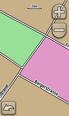
Hello, i have attached a screenshot of my Oregon to explain the problem. As you can see, the streets are not "connected" correct. I have made the map with a self made typ file and an extracted OSM file. Is there a special attribute i must set, when i compile the IMG file, or how can i solve the problem? Greetz, Tim