
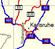
Attached is alpha coding which enables graphical highway symbols in the map. See the attached screen shot for an idea of how this looks in mapsource (the symbols A5, B36, etc. now appear on the respective highways). Display looks similar on my e-trex. - The patch works only if the label file is written in 8-bit mode (use option --latin1 with mkgmap). As I am neither a Java programmer, nor familiar with Garmin's img format, the code is pretty rough. It consists of two parts: 1. An addition to the lines style file, which inserts the special code before the highway reference (hex 0x04 for motorways, 0x05 for major highways, 0x06 for minor highways). I had to use a hex editor to insert these symbols. 2. A hack in Element.java, which removes a space if it is the second character of the highway name. This is needed because only characters up to the first space will be displayed in the graphic symbol. That is, "A 5" would be displayed as only "A" in the highway symbol, so I change "A 5" to "A5" to get a reasonable symbol. The hack is obviously a poor solution, but it serves as a proof of concept. A clever regex would be much better here, as it should catch cases such as "SS 125", etc. Sorry for the poor quality of the code, but I did not have an Internet connection when I did this; I could not look up the proper way to do things in Java (such as regexes, string comparisons, constants, etc.). I would appreciate your comments. At least the patch makes the map look cool. ;-) Cheers.