
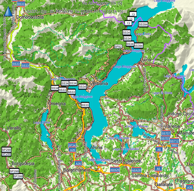
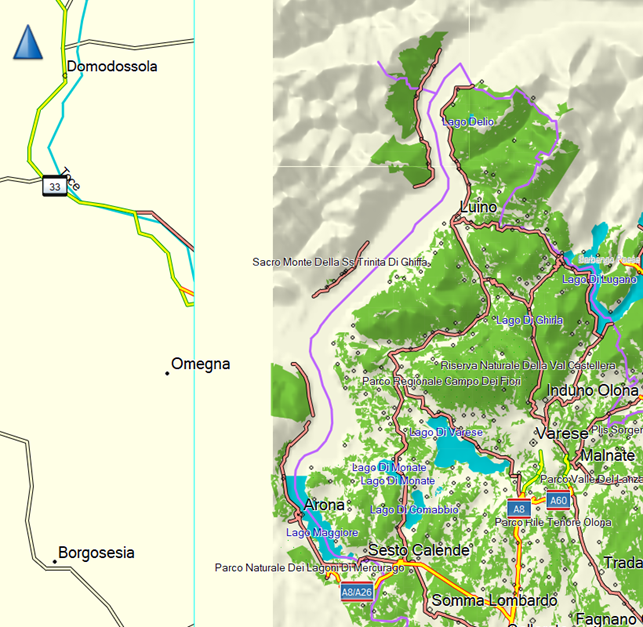
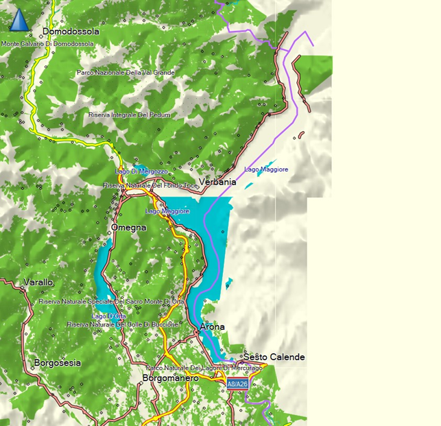
Hi Diego, the problem is not in OSM but in your extract of the OSM data which you use as input for splitter. This data doesn't contain the needed members of the multipolygon for the lake. So, you have to find the error in the method that extracts the OSM data for the region. Gerd ________________________________________ Von: mkgmap-dev <mkgmap-dev-bounces@lists.mkgmap.org.uk> im Auftrag von helter skelter <hskelter@hotmail.com> Gesendet: Montag, 13. März 2023 11:04 An: mkgmap-dev@lists.mkgmap.org.uk Betreff: [mkgmap-dev] Problem with lakes and boundary lines Hello guys I have this problem when trying to render the map of separate regions of Italy, instead of the whole country. The problem is when there is a lake across the boundary line (it happens often in Italy). If I process the whole country, the lakes are rendered correctly, like in this picture: [cid:b8ce3c0e-7457-4e1b-9644-5d286af31541] (This is Lago Maggiore, between Piemonte and Lombardia regions, north of Italy) If I render each region separately, the lake is not rendered correctly. For example, rendering Lombardia I get this (picture from Basecamp) : [cid:40bae83a-938b-4afd-bda3-88803461f55d] The left part is not rendered because it’s another region (Piemonte) and this is ok. But also the lake is rendered completely wrong: only the south part has water (near Arona city) and in the north area the water is not rendered. If I create the map of Piemonte, I have the same problem but with different rendering errors. I see no water on the north and water covering a part of the land in center-right: [cid:2dd1d2da-af03-485f-ab6b-e7be0c7fcf28] Data of regions are downloaded from: http://download.openstreetmap.fr/extracts/europe/italy/ This is my SPLITTER configuration: Splitter version 653 compiled 2022-12-27T06:20:39+0000 boundary-tags=use-exclude-list cache= description= geonames-file= handle-element-version=remove ignore-osm-bounds=false keep-complete=true mapid=13224200 max-areas=2048 max-nodes=1600000 max-threads=16 (auto) mixed=false no-trim=false num-tiles= output=o5m output-dir=C:\OSM\splitter\PIEMONTE overlap=auto polygon-desc-file= polygon-file=C:\OSM\areas_poly\regioni\PIEMONTE.poly precomp-sea= problem-file= problem-report= resolution=13 route-rel-values= search-limit=200000 split-file= status-freq=120 stop-after=dist wanted-admin-level=5 write-kml= Elapsed time: 0s Memory: Current 248MB (4MB used, 244MB free) Max 16384MB Time started: Mon Mar 13 10:18:10 CET 2023 Map is being split for resolution 13: - area boundaries are aligned to 0x800 map units (0.0439453125 degrees) - areas are multiples of 0x800 map units wide and high These are some errors I see in Splitter log: Warning: Incomplete multipolygon relation 11758 (Lago Maggiore): using bbox of unclosed polygon to calc tiles, ways: [225950136, 123006579, 1073823032, 1073823028, 190504960, 87660763, 139898093, 87660754, 87660747, 255065025, 255065026, 255065027, 202250553, 202250554, 202252112, 256006208, 256006217, 256006211, 256006196, 202273125, 87660744, 87660769, 265419850, 265419849, 196817044, 202274997, 202274999, 202275000, 202274990, 202274996, 202274993, 196817042, 263324120, 263327661, 263327665, 263324123, 265406984, 265406978, 316366060, 269138792, 269138799, 87660748, 269138796, 269138795, 87660742, 87660761, 198918369, 184747058, 184747048, 87660750, 87660757, 187360834, 87660752, 87660746, 193114167, 187361863, 87660743, 87660756, 87893267, 87893275, 87893277, 814891333, 814891342, 814891332, 814891348] Warning: Incomplete multipolygon relation 11758 (Lago Maggiore): using bbox of unclosed polygon to calc tiles, ways: [339499330, 339499338, 339499332, 339499337, 339499331] Warning: Incomplete multipolygon relation 11758 (Lago Maggiore): using bbox of unclosed polygon to calc tiles, ways: [173660449, 203517579, 203517587, 173660454] Warning: Incomplete multipolygon relation 11758 (Lago Maggiore): using bbox of unclosed polygon to calc tiles, ways: [211154423, 211154912, 366067218, 366067212, 366067214, 366067220, 366067216, 366067222] Warning: Incomplete multipolygon relation 11758 (Lago Maggiore): using bbox of unclosed polygon to calc tiles, ways: [202421534, 202421531] Warning: Incomplete multipolygon relation 11758 (Lago Maggiore): using bbox of unclosed polygon to calc tiles, ways: [202421542, 202421532, 87896545] Warning: Incomplete multipolygon relation 11758 (Lago Maggiore): using bbox of unclosed polygon to calc tiles, ways: [222482940] Warning: Incomplete multipolygon relation 11758 (Lago Maggiore): using bbox of unclosed polygon to calc tiles, ways: [222484904, 87896544, 87894927, 222496706, 222496701, 87894916, 87894926] Warning: Incomplete multipolygon relation 11758 (Lago Maggiore): using bbox of unclosed polygon to calc tiles, ways: [87893287, 186266917, 186266942, 87893262, 814465684] I took a look at OpenStreetMap but I really can’t understand if there is a problem with data and multipolygons. Do you have any idea of how I could solve this problem ? Thank you ! Diego