
Thanks - yep I'm using --precomp-sea with latest sea.zip. Thomas I'll check the typ file but I suspect if there was an issue with water bodies level that would affect all lakes, not just one. Thanks Enrico Il Mar 11 Set 2018, 07:06 Thomas Morgenstern <webmaster@img2ms.de> ha scritto:
At first look in your stylefile polygons and see how natural=water is converted to garmintyp, I prefer 0x3c, resolution 18. Second look in your typfile, if 0x3c is renderd and if the DrawPriority in typfile is high enouf. Maybee 0x3c exist, but in a low layer, which is overwriting with the other layers. thomas
Am 10.09.2018 um 23:18 schrieb Enrico Liboni:
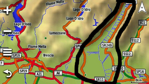
Folks, since sometime Lake Garda in Italy is not rendered correctly. I did not report this a few months ago since I was using an old version of mkgmap but I'm now using very latest one and fresh geofabrik pbf but the problem remains. At a first glance OSM data seems fine: https://www.openstreetmap.org/relation/8569
Any idea? Attached screenshot from my Garmin device, the lake should be inside the ugly black line - note other smaller lakes are rendered correctly. Lake name is also missed. I am using a custom style but I don't think that can be the cause-
Thanks, Enrico
[image: lakeGarda-black.jpg]
_______________________________________________ mkgmap-dev mailing listmkgmap-dev@lists.mkgmap.org.ukhttp://www.mkgmap.org.uk/mailman/listinfo/mkgmap-dev