
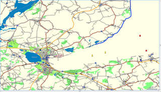
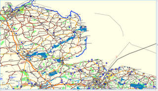
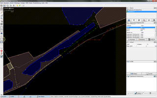
dear developers, i recognized broken coastline errors between the mkgmap verion 1188 and 1398. Please refer to the appended jpegs (my coastline is a little bit thicker ti identify the sea area). Here is the original osm position: http://www.openstreetmap.org/?lat=54.562&lon=9.983&zoom=11&layers=B000FTF You can download all the data from my server: a) version 1188: http://planetearth.informatik.haw-hamburg.de/forMapSource/schleswig-holstein... b) version 1398: http://planetearth.informatik.haw-hamburg.de/error_mkgmap-r1398_forMapSource... c) the build script: http://planetearth.informatik.haw-hamburg.de/scripte/doSchleswigHolstein.bas... d) the build script: http://planetearth.informatik.haw-hamburg.de/error_mkgmap-r1398_forSDcard/sc... It seems, that the error belongs to changes (see last jpeg) in multipolygon behavior of newer mkgmap code. Please check, whether there is a new problem in the code or in the tags from the maps. regards Michael