
29 Mar
2010
29 Mar
'10
5:49 p.m.
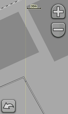
I have attached an interesting screenshot from my Oregon 400t. The map is the All in one map Europe (http://wiki.openstreetmap.org/wiki/All_in_one_Garmin_Map). You see that the light grey industrial area is splitted by a considerable yellow line. But the dark grey buildings do not have it although they are splitted by the tile bounds in the same manner. There is no multipolygon defined in the screenshots area. Maybe the boundary clipper sometimes cuts too much? I have never seen such artefacts on original garmin maps. WanMil