
24 Jul
2018
24 Jul
'18
2:12 p.m.
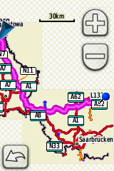
Hi Gerd, In my test, I have used MapInstall to create 3 separate img for GPS. I have run your scripts, then copied 2 created gmapsupp.img to GPS (I have renamed second one as gmapsup1.img). It works correctly for me, both in nuvi and in Dakota. See attached picture form Dakota. I have no idea, what goes wrong in your Oregon. Maybe there is some interaction with basemap? Basemap is routable and sometimes can be used for calculation. -- Best regards, Andrzej